Constraints for Karst Landscape Evolution on Vancouver Island, British Columbia, Canada: Concepts, Research Plans and Outcomes.
Earth Science Department, Vancouver Island University, 900 Fifth St, Nanaimo, British Columbia, Canada, V9R 5S5 1, Honorary Research Associate, Earth Science Department, Vancouver Island University, 900 Fifth St, Nanaimo, British Columbia, Canada, V9R 5S5 2, Cave Management Services/KarstCare, 544 Springbok Road, Campbell River, British Columbia, Canada, V9W 8A2 3
Email: tim.stokes@viu.ca 1, clramsey@shaw.ca 2, pgriff@shaw.ca 3
Abstract
A research project has been initiated to better understand the geologic, geomorphologic and hydrologic processes that have led to the evolution of karst landscapes on Vancouver Island – a mountainous region with a long glacial history and an active tectonic setting. This research aims to explain how bedrock geology, geological structures, recent and past tectonic uplift, glacial and inter-glacial events, sea level change and isostatic rebound may have influenced, constrained and/or promoted karst development in this region. Current research activities will include detailed field work and mapping at a number of carefully selected and representative karst areas on Vancouver Island, collecting information on bedrock geology, geologic structures, surface karst features, glacial materials/cover and hydrology. These surface data will be integrated with known caves that have been previously surveyed and mapped in the selected areas. It is anticipated that this research will lead towards a ‘conceptual model’ for karst development on Vancouver Island, and that results from this project will increase the overall scientific understanding, awareness and appreciation of karst issues and resource values on Vancouver Island.
Introduction
In the past 10-15 years considerable work has been completed on developing guidelines and standards in British Columbia (BC) for the assessment and management of karst landscape (RISC, 2003; BC Ministry of Forests, 2003). A recent publication titled ‘Karst Geomorphology, Hydrology and Management’ covers many of the issues and values that relate to karst in BC, and highlights methodologies for assessing and managing karst landscapes with respect to forestry activities (Stokes et al., 2011). A number of small research projects have also been carried out by the authors and other colleagues examining issues related to sinkhole microclimates, karst springs and karst aquifers (Stokes et al., 2007, 2008, 2011a and Stokes, 2012). However, less research has been done at the broader regional-scale to understand when and how karst landscapes on Vancouver Island have formed and developed over geologic time. Research is now underway to better understand the geologic, geomorphologic and hydrologic processes that have led to the evolution of karst landscapes on Vancouver Island. Through this research we aim to better understand how factors such as bedrock geology, geological structures, tectonic uplift, glacial events, sea level change and isostatic rebound may have influenced, constrained and/or promoted karst development in this region. This paper details what is currently known about karst in the region, outlines the planned research methodology and discusses possible outcomes. Some of the questions that this research will investigate are:
- What geological units and associated structures are likely to be important for karst formation on Vancouver Island?
- How have the various glacial and inter-glacial events affected karst landscape evolution?
- What influence have the past and current rates of tectonic uplift on the BC west coast had on karst development?
- Likewise, what roles have the changes in sea level and isostatic rebound played in the development of the karst?
- What are the likely ages of the surface karst features and subsurface caves/cavities?
- What can the nature and shape of known and mapped caves tell us about the rates and stages of tectonic uplift along the west coast of BC?
- What more can karst landscapes tell us about past geomorphological processes and climate history of Vancouver Island?
Regional Setting for Karst Lands on Vancouver Island
Topographically, Vancouver Island is dominated by the Vancouver Island Mountain Ranges that form the northwest-southeast ‘backbone’ of the island, rising to elevations of 2200 m (Figure 1). The lowlands on the east coast of the island are adjacent to the Salish Sea (formerly the Georgia Strait) –a relatively shallow water body that extends across to the mainland of British Columbia. The more rugged west coast of the island is dominated by fiords, inlets and islands. Vancouver Island has a temperate climate with much of the rainfall (up to 5000 mm/year) falling on the west coast, while the east coast of the island is generally drier in comparison. Most of the island is forested and occurs in the Coastal Western Hemlock biogeoclimatic zone, while the less dominant and drier Douglas Fir biogeoclimatic zone occurs along the southeast coast line.
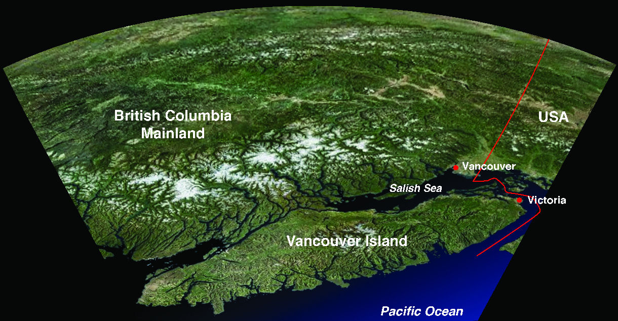
Figure 1 – Satellite image of Vancouver Island viewing towards the east and mainland British Columbia.
In total approximately 4% of Vancouver Island is underlain by limestone, much of which is karstified and occurs within the three units the Mount Mark, Quatsino and Parson Bay Formations (Figure 2). In the north of the island these limestone units occur as long and continuous belts, while in the south of the island these units are less continuous and smaller in size. A number of provincial parks have been established specifically for caves and karst on Vancouver Island, including Horne Lake Caves Park, Clayoquot Plateau Park, Weymer Creek Park, White Ridge Park, and Artlish Caves Park.
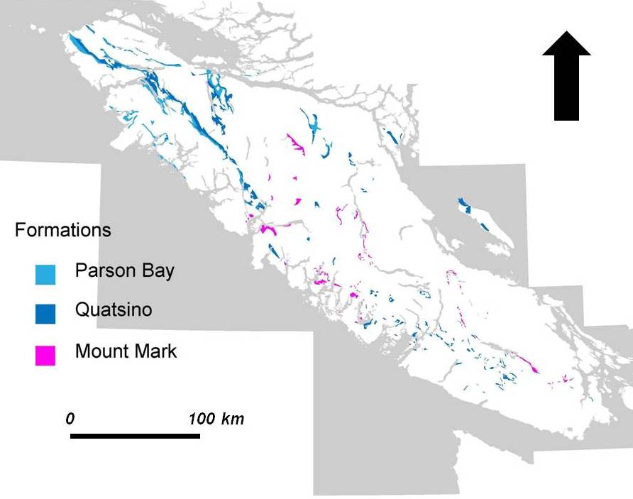
Figure 2 – Distribution of Limestone Formations on Vancouver Island
In comparison to Vancouver Island, carbonate bedrock (limestone and dolomite) underlies approximately 10% of British Columbia, but it is not all karstified. Significant areas of alpine karst occur in the northern and southern Rocky Mountains (Figure 3). Less well-known karst areas occur in northwest British Columbia (e.g., Atlin, Stuart, and Babine Lakes, as well as along the Stikine, Nakina, and Taku Rivers), and in the Interior (such as the Purcell and Pavilion Mountains). Well-developed karst areas also occur on Haida Gwaii (Queen Charlotte Islands), and in smaller areas along the north and mid-Coast, Texada and Quadra Islands, the Sechelt Peninsula, and near Chilliwack (BC Ministry of Forests, 1997).
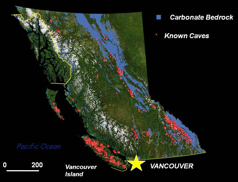
Figure 3 – Distribution of carbonate bedrock, potential karst and known caves in British Columbia
The karst landscapes on Vancouver Island occur in a wide range of geomorphic settings from alpine, mid and lower forested slopes, valley bottoms to the lowland and coast (Figure 4). Classification of these karst areas has not been formalized. A useful first approach is to consider them in terms of the physiographic regions for Vancouver Island (Figure 5), which subdivides the island into mountain ranges, fiord lands, plateaus, highlands, lowlands and basins. Examples of karst areas include White Ridge and Kinman in the northern mountain ranges, Weymer and Clayoquot in the fiord lands, Memekay and Holberg on the plateau areas, and Quadra Island and Horne Lake in the lowlands.
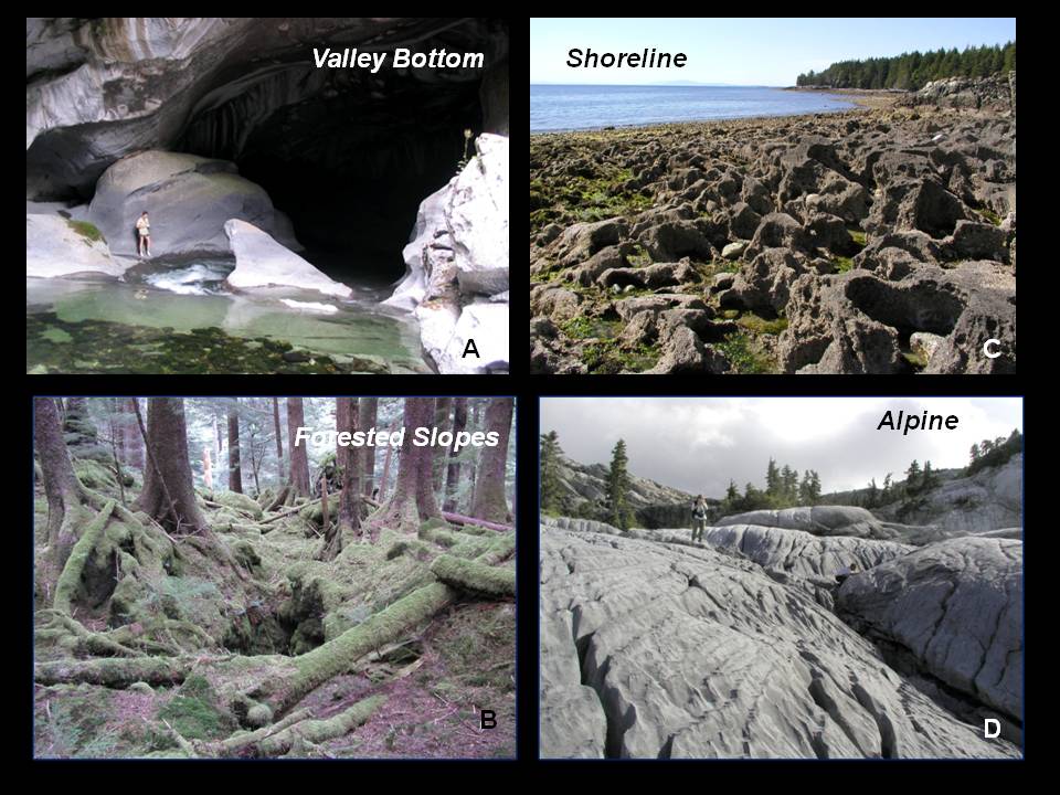
Figure 4 – Geomorphic settings of typical karst landscapes on Vancouver Island. A – Entrance to Little Hustan Cave on Atluck Creek, northern Vancouver Island B – Typical small sinkhole in forest karst. C – Limestone with solutional weathering from shoreline of Texada Island. D – Exposed and solutionally weathered limestone surface in alpine region of Central Vancouver Island.
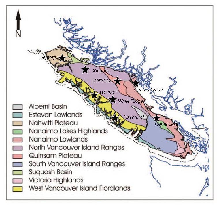
Figure 5 – Physiographic map of Vancouver Island and selected karst areas (Adapted from Yorath, 2005)
Previous Research
Research information specifically on the geology, geomorphology and hydrology of karst landscapes on Vancouver Island is quite varied. A number of theses were completed in the early 1980’s under the direction of Dr Derek Ford – a preeminent karst scientist from McMaster University. Mills (1981) used multiple lines of evidence, including hydrochemical analyses, and examinations of surface and subsurface landforms to better understand groundwater flow patterns and their constraints on karst development in the Benson River Valley and Gibson Plateau areas of Northern Vancouver Island. Ecock (1984) focused on White Ridge, an alpine karst area on the west coast of the island, and examined the hydrological balance between the precipitation/infiltration on the upland karst surface to the spring discharge downslope. Harding (1987) focused on soil loss and timber harvesting activities of karst areas in northern Vancouver Island (Harding and Ford, 1993). A series of earlier studies were also completed at Horne Lake Caves Provincial Park (Ford, 1975; Copland, 1982; Smart, 1986) investigating issues related to hydrology and speleogenesis of the caves. Sediments and mineral formations indicated that cave development in this area possibly spanned the past 140,000 years. This data was supported with U-Th dating in Cascade Cave near Port Alberni, which indicated two periods of cave speleothem formation – 33,000 - 55,000 BP and less than 15,000 BP, both of which were linked to interglacial warming events (Gascoyne, 1981).
A number of other research projects using geochronological and geochemical analysis of speleothems from caves on Vancouver Island have also been completed. Latham et al., (1982) applied paleo-magnetism and U-Th dating to estimate the age of speleothems for a number of caves on the island, but there were some concerns with the accuracy of the results. Marshall et al., (2009) used C and O isotopes and U-Th dating of speleothems from a cave in the Port McNeill area to document climate/temperature changes for the past 12,000 years. A similar climate change study was completed by Zhang et al., (2008), who utilized H and O isotopic analysis of fluid inclusions within speleothems collected from a cave on the west side of Vancouver Island.
In terms of mapping of karst landscapes of Vancouver Island, a series of karst potential maps were developed for both Vancouver Island and the rest of BC, using existing geologic information on bedrock units and regional knowledge of karst and cave features (Stokes, 1999). Another karst potential map was also developed for Vancouver Island, as part of a series of Geomorphic Maps on Vancouver Island (Guthrie, 2005).
Primary Constraints of Karst Landscape Development and Evolution
Karst landscapes on Vancouver Island are primarily due to the dissolution of limestone. In general, this dissolution at upper elevation (alpine) areas is likely dominated by the vertical infiltration of rain and snow (i.e., more holokarst-type), while mid and lower elevations sites are also influenced by allogenic surface streams (i.e., more fluviokarst-type), and the valley bottoms by larger river systems. The rate and amount of dissolution, and the overall development process of these landscapes, is still open to discussion, and dependent on a wide range of chemical and physical factors such as: the nature and type of limestone, the amount and chemistry of the water, the type and thickness of soil-cover/regolith, the type and extent of vegetation cover, the thickness of and/or the presence of interbeds within limestone units, the intensity and orientation of fracturing, localized climatic conditions, and hydraulic head. Other geologic/geomorphic factors that may constrain the development of karst landscapes include: past glaciations, sea level rise and fall, and the rates of landscape uplift and erosion.
Nature & Characteristics of Vancouver Island’s Limestone Units
The Late Permian Mount Mark Formation is the oldest of the three limestone units on Vancouver Island. This unit is generally comprised of a grey, well-bedded crinoidal limestone with minor interbeds of chert and argillite (Fischl, 1992). The type section, found at Horne Lake, is approximately 350 m thick and is characterized by a thick bedded lower unit that grades into thinner bedded and laminated middle unit with interbeds of shale and chert, that is overlain by an upper unit that is more massive and thicker bedded (Yorath et al., 1999). In many cases the Mount Mark Formation limestone is moderately to steeply dipping, and forms small (100-1000s m long and 10-100s m wide) geologic zones that are relatively deformed and generally separated from other rock units by faults.
The Late Triassic Quatsino Formation is proportionally the largest limestone unit on Vancouver Island and is comprised of a light grey to black, massive to thick-bedded and micritic limestone, with a general lack of obvious fossil material (Figure 6). The lower part of this approximately 750 m thick formation is dominated by massive to thick-bedded limestone, while the upper part grades into a dark grey to black and flaggy limestone with intercalations of black shale. These black shale beds gradually become thicker and change into the shale dominated Parson Bay Formation. For the most part the Quatsino Formation forms three belts that are 10s km-long, 100s m wide and occur in the north of the island. One belt can be traced for over 150 km (Fischl, 1992). Generally, the Quatsino Formation is gentler dipping and less deformed than the Mount Mark Formation. This might in part be a function of its younger age, and/or the different style of tectonic deformation in the north of the Island. The Parson Bay Formation conformably overlies the Quatsino Formation and is up to 600 m thick, and is comprised of thinly bedded layers of black argillite, calcareous siltstone and sandstone, and grey to black limestone. Typically, the Parson Bay Formation occurs in close proximity to the Quatsino Formation, however it can also be found as small and isolated bodies (or faulted blocks).
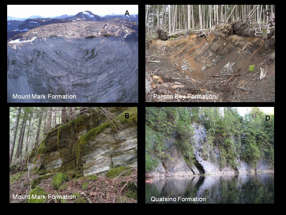
Figure 6 – Field Photographs of the Mount Mark, Quatsino and Parson Bay Formations. A – Aerial view of large synclinal fold in limestone of Mount Mark Formation in Strathcona Park. B – Moderately dipping and slightly foliated limestone beds of the Mount Mark Formation, Port Alberni Area. C – Thin interbedded limestone and black shale beds of the Parson Bay Formation, Holberg Area. D – Moderately dipping and medium to thick beds of Quatsino Formation, Devil's Bath, northern Vancouver Island.
Karst is known to develop in all three of the above formations. However, it is generally better developed and more extensive in the limestone-dominated and calcite-rich (>90% CaCO3) Mount Mark and Quatsino Formations. Karst does develop in the limestone layers of the Parson Bay Formation, but is often inhibited in the clastic and carbonaceous-rich layers, commonly resulting in karst with a more striped appearance.
Geologic History and Tectonic Deformation
The Mount Mark, the Quatsino and the Parson Bay Formations are all part of the Wrangellia Terrane, which is Devonian to Jurassic in age, and primarily comprised of inter-layered volcanic and sedimentary units along with some late stage granitic intrusions (Figure 7). Wrangellia is considered to have formed a significant distance offshore from North America within the ancient Pacific Ocean by a combination of intraplate superplume volcanism and island arc activity (Richards et al., 1991). Over time Wrangellia gradually drifted towards continental North America, and eventually collided with this region approximately 100-120 Ma. Vancouver Island, Haida Gwaii and parts of Southeast Alaska are all now remnants of this terrane. Two smaller terranes, the Pacific Rim and Crescent, collided with the southeast end of Vancouver Island approximately 55 Ma and 42 Ma ago, respectively.
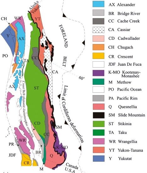
Figure 7 - Geologic terranes of British Columbia and the Yukon. Note, Wrangellia Terrane (lilac) that was accreted onto the west coast of British Columbia and Alaska (Sourced from Ricketts, 2008)
Past tectonic activity, terrane collisions and associated structural deformation have played a major role in developing the landscape of Vancouver Island, resulting in a region dominated by northwest-southeast trending mountain ranges and river valleys. Some of the earliest structures are found in the oldest rocks of Wrangellia – the Devonian Sicker Group – which has been exposed and uplifted, resulting in regional anticlinal structures with northwest-southeast axial traces that can be followed along much of the island’s length (Yorath et al., 1999, Figure 8). These fold structures are likely related to early compressive deformation prior to and/or during the collision of Wrangellia to North America in the Late Jurassic. After and/or during the terrane collision strike-slip faulting became dominant in the north and centre of the Island, as evident from conjugate faults sets with northeast and northwest trends (Jones et al., 2006). Normal faulting then developed in the Mid Cretaceous during a period of extension, and resulted in a major basin forming between Wrangellia and the North American continent. Late Cretaceous and clastic sedimentary rocks of the Nanaimo Group then accumulated within this basin. In the Eocene a fold and thrust belt system developed in the south of the Island due to the collisions of the Pacific Rim and Crescent Terranes (England and Calon, 1991) and resulted in numerous northwest-trending and southwest-verging thrust fault zones (e.g., Cowichan Lake Fault).
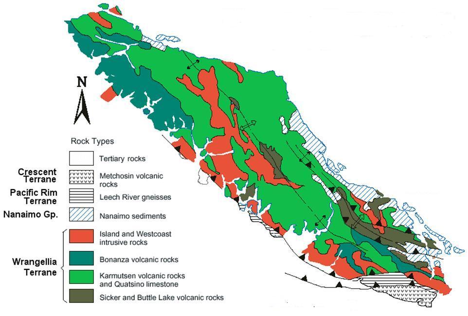
Figure 8 - Geology of Vancouver Island illustrating different rock units and major structures -anticlines and thrust faults. (Sourced from teaching web site of Steve Earle, Vancouver Island University. http://web.viu.ca/earle/geol111/geology-of-vancouver-island.pdf Accessed July 31, 2013)
The Mount Mark Formation underwent some of the early compression and deformation on the island, as evident from major fold structures apparent within this unit. Subsequent strike-slip faulting in the north and central parts of the island were likely responsible for much of the tilting and separation of the Quatsino and Parson Bay Formations into elongated belts. The late Eocene thrust faulting may have also played a role in the deformation and separation of the small limestone zones found in the south of the island. Fracturing would have accompanied all deformational phases and resulted in a wide range of joints that cross-cut and transect bedding within the limestone units. These joints, along with faults and the bedding planes, likely constrain the orientation and shapes of many karst solutional openings present in the limestone units. Mills (1981) also noted that intrusive structure (e.g., dykes) also played a role in constraining the location and shape of subsurface openings.
Vancouver Island remains a tectonically active region, with the subduction of the Juan de Fuca Plate below North American Plate (Figure 9). This subduction started approximately 35-40 Ma ago and has resulted in many of the major volcanic centres that have formed along the west coast of North America (Wood and Kienle, 1990). The configuration and rates of this plate subduction have changed over time, with part of the Juan de Fuca plate splitting off to the north and forming the Explorer Plate 4 Ma ago, and part splitting off to the south forming the Gorda Plate 5-18 Ma ago (Wood and Kienle, 1990). Current rates of subduction convergence are in the order of 40-50 mm/year, while associated rates of uplift on Vancouver Island are 1-4 mm/year (Hyndman and Rogers, 2010). The rates and directions of convergence and uplift have likely varied over time, and have also periodically changed during large, cyclical (300-600 years) subduction earthquakes (Hyndman and Rogers, 2010). Tectonic uplift has resulted in mountain building, which in turn is responsible for a range of factors that could influence karst landscape development, such as changes to hydraulic heads, stream base levels, erosion rates and local climatic conditions. All of these factors are important constraints to consider in the 10,000’s to 100,000’s years time scale of karst landscape evolution on Vancouver Island.
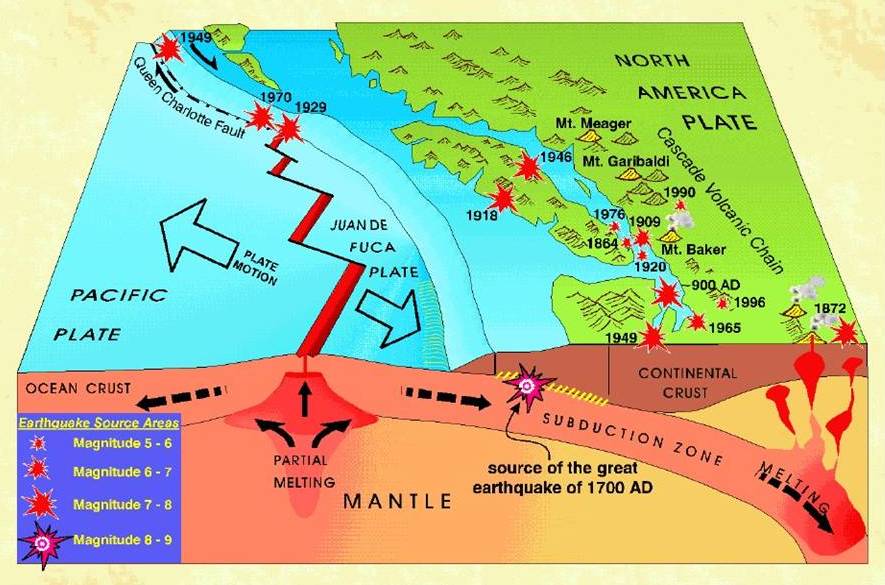
Figure 9 - Current plate tectonic setting of Vancouver Island including recent earthquake activity and volcanic centres on Mainland BC. (Sourced from Natural Resource Canada web site http://www.nrcan.gc.ca/sites/www.nrcan.gc.ca.earth-sciences/files/gif/vancouver/images/earth2_e.gif, July 31, 2013.)
Glacial History
Vancouver Island has undergone extensive glaciations with at least twenty glacial cycles during the last 2.6 Ma of the Quaternary. Many of the earlier glacial events have been masked by later ones, however, evidence for the last 2-3 glacial events are well documented on Vancouver Island and Southwest BC (Yorath, 2005). The Fraser Glaciation is the last and most well documented glacial cycle that started 29,000 years BP, which began to retreat 14,500 years BP and had almost disappeared by 11,500 years BP (Ryder et al., 1991). This glacial event and others are tied to advances and retreats of the Cordilleran Ice Sheet, which developed as a large ice mass extending out from the Coast Mountains and Vancouver Island Ranges, and then met in the Salish Sea and moved southward to the Puget Sound (Figure 10). This km-thick ice sheet would have covered most of Vancouver Island, except for possibly the highest peaks (>2000 m), and some isolated refugium areas on the west coast (e.g., Brooks Peninsula; Hebda et al., 1997). Significant amounts of bedrock would have been scraped from the landscape surface and moved downslope, eventually being deposited as glacial sediments of varying thicknesses on the mid-slopes, lower slopes and valley bottoms.
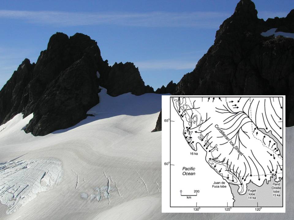
Figure 10 – Glacier from Northwest of Tahsis in Central Vancouver Island, with inset illustrating extent of the Cordilleran Ice Sheet at the peak of the Fraser Glaciation 14,000-16,000 years ago. (Inset sourced from Clague and James, 2002)
Past glacial events would have had a dramatic effect on any existing karst landscapes on Vancouver Island, as the thick ice sheets moved across the surface. The upper (epikarst) layer of any karst landscapes present could easily have been removed, based on an estimate of 4.8 + 2.8 mm/year for bedrock removal due to the ice sheet erosion (Cowton et al., 2011). The exact nature and extent of glacial erosion might also be dependent on the topographic setting of the limestone units – alpine, shoreline, valley bottom, etc. In some cases the slightly softer limestone units (relative to surrounding basaltic and granitic rocks) might be preferentially eroded forming lowlands (e.g., Central Quadra Island). Glaciation will also have a major effect on the karst hydrology (Ford, 1983), hindering karst development by infilling subsurface conduits with sediments, redirecting flows and freezing, or alternatively enhancing karst development with sub-glacial water flow and melt-water floods being directed into sink points. Glacial waters would also move significant amounts of glacial sediment into and/or through karst conduit systems. At the end of glacial cycles, sediment also buried lower elevation karst landscapes, which function hydrologically with water flow in subsurface conduits, but whose presence might only become evident when openings breach the surface – over time and/or following land disturbance. It is therefore evident that glacial events have great potential to remove, disrupt, bury, infill and flush material through karst landscapes (Figure 11). All of the processes may have affected the karst landscapes on Vancouver Island not once, but possibly a number of times.
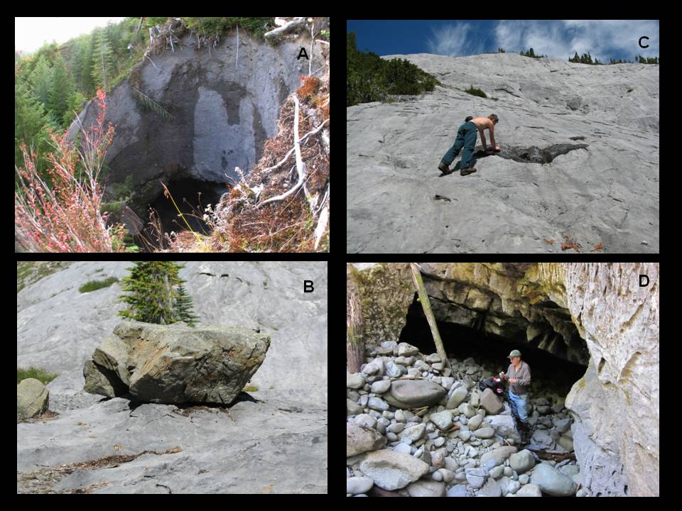
Figure 11 – Glacial effects on karst of Vancouver Island. A – Large collapse feature in glacial till above known cave openings. B – Glacial erratic upon limestone pedestal that has formed since placement of rock. C – Striated limestone pavement in alpine karst setting. D – Rounded glacial and fluvial rock debris infilling cave entrance
Sea Level Change and Isostatic Rebound
Glaciation has also played a major role in sea level change and isostatic rebound of Vancouver Island. The best record for sea level change and isostatic rebound comes from the most recent glacial cycle when during the onset of the Fraser Glaciation sea level is thought to have dropped by up to 150 m and the overlying ice sheet depressed Vancouver Island by up to 300 m (Yorath, 2005). Following glacial retreat 14,500 years ago and removal of the ice mass, rapid isostatic rebound occurred and was faster than sea level rise. This result resulted in a number of raised beaches now found along the coastline of southwest BC (Figure 12, Clague and James, 2002). Eventually sea level reached its current level around 5000 years ago. These changes in sea level rise and associated isostatic rebound would probably have had profound effects on karst landscape development by altering groundwater circulation patterns, stream base levels, hydraulic heads and the exposure of karst landscapes, particularly at lower elevations.
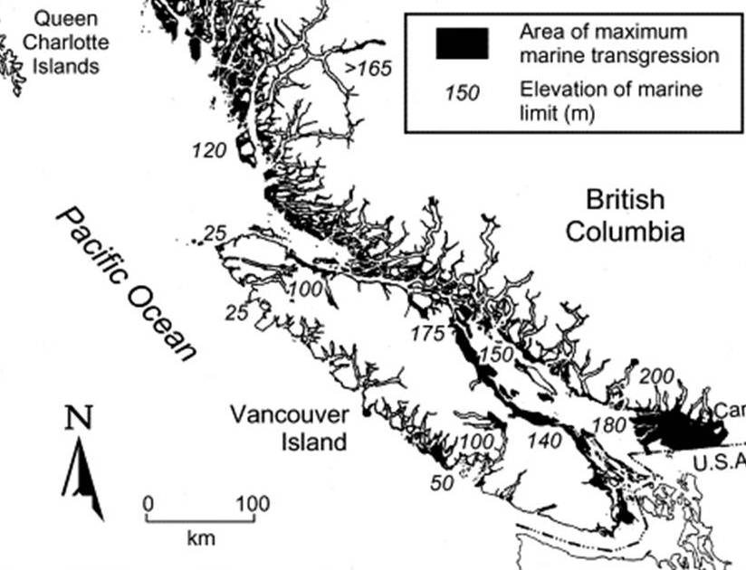
Figure 12 – Raised beaches in British Columbia that developed since the end of the last glacial period 11,000 years ago. (Sourced from Clague and James, 2002)
Research Methodology
Current research activities aim to complete detailed fieldwork at a number of carefully selected and representative karst areas on Vancouver Island. It is anticipated that these areas will include: examples of the three carbonate units on Vancouver Island (Quatsino, Parson Bay and Mount Mark Formations), different geographic locations (north, central and southern Vancouver Island), varied geologic/structural domains, and diverse topographic settings (alpine, mid-slopes, coastal). It is intended that the sites will have close spatial association to known caves that have been previously surveyed and mapped. Possible sites include: Benson River, Kinman Creek and Memekay River areas in the north and central part of Vancouver Island, White Ridge on the west coast, Horne Lake and the Port Alberni area in the southern part of the Island, and Quadra Island. An important part of the project will be to examine some of the available cave maps of the selected areas, and to integrate these into their respective geographic and geologic context. The shape, nature and elevation of cave passages when correlated to the host limestone unit, geologic structures and topography may provide indications as to how, when and why the karst landscape developed. Significant vertical or horizontal passages in caves could also provide clues for rapid landscape uplift or stability, respectively (Piccini et al., 2003). Field work in the selected sites will focus on mapping the boundaries of the host karst units, the types of surface karst features, and distribution of bedrock fractures and geologic structures. Field data will also be collected on host bedrock lithology, glacial/surficial materials and hydrological features. A key part of the data compilation will be to develop detailed geological maps for the selected sites and to incorporate this information into a GIS database. Where possible cave maps will be digitized and incorporated into 3D models, integrating surface and subsurface data.
Anticipated Outcomes and Applications
The main outcome of this research will be to develop a better understanding of how and when karst landscapes have developed on Vancouver Island integrating what is observed on the surface with what is known from the underground. It is anticipated that this research will gradually lead towards a ‘conceptual model’ for karst development on Vancouver Island that will take into account the various constraints discussed above. It is intended that results from this project will increase the overall scientific understanding, awareness and appreciation of karst issues and resource values on Vancouver Island. For example, issues related to the age of the host rocks and timing of karst development are either not included, or are unclear, on interpretative signage at a number of karst recreation sites on the Island (e.g., Alice Lake Loop, Upana Caves, Little Hustan Caves). A better understanding of these issues can be used to enhance the general public’s interest and understanding of these valuable resources. Research will also highlight the importance of karst landscapes to other scientists, and possibly provide additional information on the glacial, climate change and tectonic history of Vancouver Island and Coastal British Columbia. This research will also contribute to the ongoing discussions related to forestry and other land use activities on karst, by providing sound geoscience information for decision makers in terms of the characteristics, nature and functions of this important, but different, landscape.
Conclusion
It is apparent that the geology, tectonic history and past glacial events have been significant in forming the mountainous terrain of Vancouver Island, and that these factors are key constraints for the development of karst landscapes in this region. Recent tectonic uplift, sea level changes and isostatic rebound are also other important constraints to consider. Previous geochronological dating within caves of Vancouver Island has indicated at least two periods of speleothem growth during the last and present interglacial events (55,000 – 33,000 years BP and less than 15,000 years BP, respectively), with some cave morphological evidence suggesting older ages (>100,000 years BP) for subsurface karst development. In many areas the karst features encountered at the surface are likely post-glacial (<14,500 years BP), with any earlier features removed by glacial erosion. However, it is possible that in some areas glaciation may have altered or enhanced surface karst features by channeling of melt waters and other processes, rather than eroding them (Mills, 1981). Current research activities entail mapping selected and representative areas of karst on Vancouver Island, as well as collecting data on landscape characteristics, bedrock structures and surficial geology. Cave morphological information, including the orientation and shape of subsurface passages, will be integrated with the surface bedrock/karst geology and topographic/elevation data. Overall, this research will aim to better understand the geologic and geomorphologic processes that have led to the evolution of these unique and valuable landscapes on Vancouver Island. It is anticipated that this research will eventually lead towards a ‘conceptual model’ for regional karst development on Vancouver Island. Research may also aid in unraveling other aspects of the glacial processes, climate change and tectonic history of Vancouver Island and the west coast of BC.
Acknowledgements
Thanks must be given to Steve Earle (Geology Department, Open Learning, Thompson Rivers University) for his careful review of this document, particularly for the sections related to the glacial and tectonic history of Vancouver Island.
References
BC Ministry of Forests. (1997). Karst in British Columbia: a complex landscape sculpted by water. Information brochure from the Forest Practices Branch. http://www.for.gov.bc.ca/hfp/publications/00192/
BC Ministry of Forests. (2003). Karst Management Handbook for British Columbia. BC Ministry of Forests, Research Branch, Victoria, B.C. http://www.for.gov.bc.ca/hfp/publications/00189/Karst-Mgmt-Handbook-web.pdf
Clague, J. and James, T. (2002). History and isostatic effects of the last ice sheet in southern British Columbia. Quaternary Science Reviews, vol 21, p.71-87
Copland, H. (1982). Geology and genesis of limestone caverns at Horne Lake Provincial Park. Vancouver, BC. Bsc Honours Thesis, Department of Geological Sciences, UBC
Cowton, T., Nienow, P., Bartholomew, I., Sole, A and Mair, D. (2011). Rapid erosion beneath Greenland ice sheet. Geology, v.40, no.4., p 343-346.
Ecock, K. (1984). The hydrology of an alpine karst: White Ridge, Vancouver Island. Unpublished MSc thesis, McMaster University.
England, T. and Calon, T. (1991). The Cowichan fold and thrust system, Vancouver Island, southwestern British Columbia. Geological Society of America Bulletin, v. 103. pp. 336-262.
Fischl, P. (1992). Limestone and dolomite resources in British Columbia. Open File 1992-18. Mineral Resources Division, Geological Survey Branch, BC Ministry of Energy, Mines and Resources.
Ford, D. (1975). Report on the Euclataws-Main Cave System of Horne Lake Caves Provincial Park, Vancouver Island. Unpublished report completed for Parks Branch, Department of Recreation and Conservation, British Columbia.
Ford, D. (1983). Effects of glaciation upon karst aquifers of Canada. Journal of Hydrology, Volume 61, Issues 1–3, p.149–158.
Gascoyne, M. (1981). Late Pleistocene chronology and paleoclimate of Vancouver Island determined from cave deposits. Canadian Journal of Earth Sciences. v.18, p.1643–1652.
Guthrie, R. H., (2005). Geomorphology of Vancouver Island: Research Report No. RR01. Victoria, BC: BC Ministry of Environment.
Harding, K. (1987). Deforestation on limestone slopes of Northern Vancouver Island. Unpublished MSc thesis, McMaster University.
Harding, K. and Ford, D.C. (1993). Impacts of primary deforestation of limestone slopes of Northern Vancouver Island, British Columbia. Environmental Geology, v.21, p.137-143
Hebda, R.J, Howes, D. and Maxwell, B. (1997). Brooks Peninsula: An ice age refugium on Vancouver Island – Chapter 15: Brooks Peninsula as an Ice Age Refugium. Occasional Paper No. 5, Ministry of Environment, Land & Parks.
Hyndman, R. and Rogers, G. (2010). Great earthquakes on Canada’s west coast: a review. Canadian Journal of Earth Science vol. 47, p.801-820.
Jones, S., Berry, R. and Sinclair, B. (2006). Multiple deformation episodes at Myra Falls volcanic hosted massive sulfide camp, central Vancouver Island, British Columbia, Canada. Canadian Journal of Earth Science, v43 p.1711-1732.
Latham, A., Schwarcz, H.P., Ford, D.C. and Pearce, G.W. (1982). The paleomagnetism and U–Th dating of 3 Canadian speleothems: evidence for the westward drift, 5.4–2.1 ka BP. Canadian Journal of Earth Sciences v.19, p. 1985–1995.
Marshall, D., Ghaleb, B., Countess, R. and Gabities, J. (2009). Preliminary paleoclimate reconstruction based on a 12,500 year old speleothem from Vancouver Island, Canada: Stable isotopes and U–Th disequilibrium dating. Quaternary Science Reviews, vol. 28, p.2507-2513.
Mills, W. (1981). Karst development and groundwater flow in the Quatsino Formation, Northern Vancouver Island. Unpublished MSc thesis, McMaster University.
Piccini, L., Drysdale, R. and Heijnis, H. (2003). Karst morphology and cave sediments as indicators of uplift history in the Alpi Apuane (Tuscany, Italy). Quaternary International, v.101-102, p. 219-227
Resources Information Standards Committee (RISC). (2003). Karst Inventory Standards and Vulnerability Assessment Procedures for British Columbia. Version 2. Victoria, B.C. http://ilmbwww.gov.bc.ca/risc/pubs/earthsci/karst_v2/karst_risc.pdf
Richards, M. A., Jones, D. L., Duncan, R. A. and DePaolo, D. J. (1991). A mantle plume initiation model for the Wrangellia flood basalt and other oceanic plateaus. Science 254, p263-267.
Ricketts, B. (2008). Cordilleran Sedimentary Basins of Western Canada Record 180 Million of Terrane Accretion. Sedimentary Basins of the World, vol 5, p.363-394.
Ryder, J., Fulton, R. and Clague, J. (1991). The Cordilleran ice sheet and the glacial geomorphology of Southern and Central British Columbia. Géographie Physique et Quaternaire, v.45, n.3, p 365-377.
Smart, C. (1986). Horne Lake Caves Park Hydrological Study. Unpublished Report completed for Parks and Outdoor Recreation Division, Ministry of Lands, Parks and Housing, British Columbia.
Stokes, T.R. (1999). Reconnaissance Karst Potential Mapping for British Columbia. BC Ministry of Forests, Research Branch. http://ftp.for.gov.bc.ca/hre/external/!publish/karst/
Stokes , T.R. (2012). Aquifer Characteristics and Water Quality Issues from Forested Karst Landscapes of Vancouver Island, British Columbia, Canada. Abstract presented at the International Associated of Hydrogeologists Congress, Niagara Falls, September 2012.
Stokes, T.R., Griffiths, P. and Ramsey, C. (2007). Preliminary microclimate study of forested karst sinkholes, Nimpkish River Area, Northern Vancouver Island, British Columbia, Canada. Poster presented at 17th Australasian Conference on Cave and Karst Management, Buchan, New South Wales.
Stokes, T., Ireland, L. and Cielanga, N. (2008). Forested karst research activities on Quadra Island, British Columbia. Australasian Cave and Karst Management Journal. v73. p. 37–40.
Stokes, T., Griffiths, P. and Ramsey, C. (2011). Geomorphology, Hydrology and Management of Karst Landscapes in British Columbia. Chapter 11 in book titled ‘Compendium of Forest Hydrology and Geomorphology in British Columbia’. Handbook 66 published by BC Ministry of Forests and Range. http://www.for.gov.bc.ca/hfd/pubs/docs/Lmh/Lmh66/Lmh66_ch11.pdf
Stokes, T., Griffiths, P. and Ramsey, C. (2011a). Hydrogeological Investigations and Sinkhole Research on Forested Karst Landscapes of Coastal British Columbia, Canada 2011 International Conference on ‘Karst Hydrogeology and Ecosystems’, Bowling Green, KY, USA, June 2011
Yorath, C.J., Sutherland Brown, A. and Massey, N. (1999). Lithoprobe, Southern Vancouver Island, British Columbia: Geology. Geological Survey of Canada Bulletin 498. 145 p.
Yorath, C.J. (2005). The Geology of Southern Vancouver Island. Harbour Publishing Co. Ltd. 205 p.
Wood, C. and Kienle, J. (1990). Volcanoes of North America: United States and Canada. Published by University of Cambridge Press. 351 p.
Zhang, R., Schwarcz, H., Ford, D., Schroeder, F. and Beddows, P. (2008). An absolute paleotemperature record from 10 to 6 ka inferred from fluid inclusion D/H ratios of a stalagmite from Vancouver Island. Geochemica et Cosmochimica Acta, vol. 72, p1014-1026.