Managing Access to Caves in the Digital Age
1 Department of Environment and Conservation 2 Cavers Leeuwin Inc.
Email: 1 anne.wood@dec.wa.gov.au
Abstract
After an explosion of caving activity in the south west of WA in the 1960s to 1980s controls have been gradually put in place. WA speleological groups initiated the Caves Access Committee to manage access to the more vulnerable sites. This incorporated voluntary restriction of group size and trip frequency as well as gating select sites. Later Government initiatives included the formation of the Caves Management Advisory Committee, the introduction of the Cave and Abseil Permit System, removal of restricted access caves from maps, and the introduction of a Cave Leader Course.
These initiatives have seen a reduction in cave rescues, a reduction in non show cave visitation, and a reduction in visitor impacts.
Several developments in recent years have the potential to reverse much of the progress made in the past two decades. The power of the internet and associated search engines, the development of GPS technology and its infiltration into broader society, and the activity of geocaching are examples of digital technology that can potentially impact on the management of access to caves and increase undesirable visitor impacts.
Introduction
There is no doubt that the age of the internet, web pages and GPS technology have brought massive managerial change to our natural world. In one small but destructive instance demonstrated by the U.S. military blowing Al Quaida operatives out of the remote Tora Bora caves in Afghanistan. But closer to home, the same technologies are having implications in recreational caving in the delicate and irreplaceable environment of the aeolian calcarenite of the Leeuwin-Naturaliste ridge.
The sites we are concerned with in this paper are the non show cave sites in the Leeuwin-Naturaliste National Park, in the extreme south west of Western Australia. They range from sites that may be visible from a public road to an astute observer to sites that are well off the beaten track. They may be difficult to find, in karri forest or dense coastal heath with no path indicating the location. Many of these sites rely on their obscurity as their main protection.
Recent History and Management Initiatives
As background to this paper, we will briefly outline the history of cave access in the Leeuwin-Naturaliste National Park (LNNP). Prior to the 1990’s, access to the caves was pretty much unfettered, self governed quite successfully by caving groups, with the support and blessing of relevant government agencies. Following an explosion of recreational and commercial access in the 1980’s and early 1990’s, with, at some sites, major environmental degradation, a permit system, cave management classification and leader accreditation was introduced. Caving groups and other stakeholders in WA stood at the forefront and took ownership of the whole process, indeed dragging the department that is now the Department of Environment and Conservation (DEC) into cave management. Consequently the over 100 caves with dark zones, and the myriad other karst features in the LNNP are now classified as public access, adventure or restricted access, with a permit and leader accreditation required for access into all caves in the LNNP with the exception of Calgardup Cave and Giants Cave, which are operated as show caves.
|
Classification |
User Group |
Recommended Management |
||||||||||||||||||||||||||||||||||||||||||||||||||||||||||||||||||||||||||||||||||||||||||||||||||||||||||||||||||||||||||||||||||||||||||||||||||||||||||||||||||||||||||||||||||||||||||||||||||||||||||||||||||||||||||||||||||||||||||||||||||||||||||||||||||||||||||||||||||||||||||||||||||||||||||||||||||||||||||||||||||||||||||||||||||||||||||||||||||||||||||||||||||||||||||||||||||||||||||||||||||||||||||||||||||||||||||||||||||||||||||||||||||||||||
|
PUBLIC ACCESS |
TOURIST CAVE (Guided or self-guided) eg. Crystal Cave, Yanchep National Park (YNP); Calgardup Cave, Leeuwin-Naturaliste National Park (LNNP) |
General public |
|
|||||||||||||||||||||||||||||||||||||||||||||||||||||||||||||||||||||||||||||||||||||||||||||||||||||||||||||||||||||||||||||||||||||||||||||||||||||||||||||||||||||||||||||||||||||||||||||||||||||||||||||||||||||||||||||||||||||||||||||||||||||||||||||||||||||||||||||||||||||||||||||||||||||||||||||||||||||||||||||||||||||||||||||||||||||||||||||||||||||||||||||||||||||||||||||||||||||||||||||||||||||||||||||||||||||||||||||||||||||||||||||||||||||||
|
ADVENTURE CAVE –Class 1 eg Tunnel Creek, Kimberley. |
General public |
|
||||||||||||||||||||||||||||||||||||||||||||||||||||||||||||||||||||||||||||||||||||||||||||||||||||||||||||||||||||||||||||||||||||||||||||||||||||||||||||||||||||||||||||||||||||||||||||||||||||||||||||||||||||||||||||||||||||||||||||||||||||||||||||||||||||||||||||||||||||||||||||||||||||||||||||||||||||||||||||||||||||||||||||||||||||||||||||||||||||||||||||||||||||||||||||||||||||||||||||||||||||||||||||||||||||||||||||||||||||||||||||||||||||||||
|
ADVENTURE CAVE - Class 2 (horizontal) eg. Golgotha Cave, Calgardup Window Extension (LNNP) Yonderup Cave, Mambibby Cave (YNP). - Class 3 (Vertical) eg Mill Cave (LNNP) |
Novice groups (general public) lead by an experienced leader, eg. school groups and licensed commercial tour operators. Speleologists. |
|
||||||||||||||||||||||||||||||||||||||||||||||||||||||||||||||||||||||||||||||||||||||||||||||||||||||||||||||||||||||||||||||||||||||||||||||||||||||||||||||||||||||||||||||||||||||||||||||||||||||||||||||||||||||||||||||||||||||||||||||||||||||||||||||||||||||||||||||||||||||||||||||||||||||||||||||||||||||||||||||||||||||||||||||||||||||||||||||||||||||||||||||||||||||||||||||||||||||||||||||||||||||||||||||||||||||||||||||||||||||||||||||||||||||||
|
RESTRICTED ACCESS |
Restricted Access Note: All caves are in this category unless designated otherwise. ref. 2.4.2 |
Experienced and responsible speleologists, scientists. |
|
|||||||||||||||||||||||||||||||||||||||||||||||||||||||||||||||||||||||||||||||||||||||||||||||||||||||||||||||||||||||||||||||||||||||||||||||||||||||||||||||||||||||||||||||||||||||||||||||||||||||||||||||||||||||||||||||||||||||||||||||||||||||||||||||||||||||||||||||||||||||||||||||||||||||||||||||||||||||||||||||||||||||||||||||||||||||||||||||||||||||||||||||||||||||||||||||||||||||||||||||||||||||||||||||||||||||||||||||||||||||||||||||||||||||
DEC CAVE MANAGEMENT CLASSIFICATION SYSTEM (2006)
Results
The management initiatives that have been introduced since 1990 can be expected to have resulted in changes to visitation figures for adventure caves and karst abseil sites, the number of cave rescues, and visitor impacts.
Visitation figures for cave and abseil (karst) permits show a steady decline from 1993 to 2010, reflecting in part the increasing number of hurdles to be jumped to obtain a permit; in chronological order – self registration as a leader, a current first aid certificate, cave leader accreditation, requirement to maintain currency by keeping a log book, registration as a single pitch abseil guide under the National Outdoor Leader Registration Scheme (NOLRS) for vertical entry sites and abseiling. Other factors may be the increasing amount of administrative paperwork required for out of school excursions and the change in the perception of risk and adventure in a society where people spend ever increasing amounts of time in front of a screen. These figures do not include entry into Giants and Calgardup Caves, both managed as unlit self-guide show caves, where visitation is increasing.
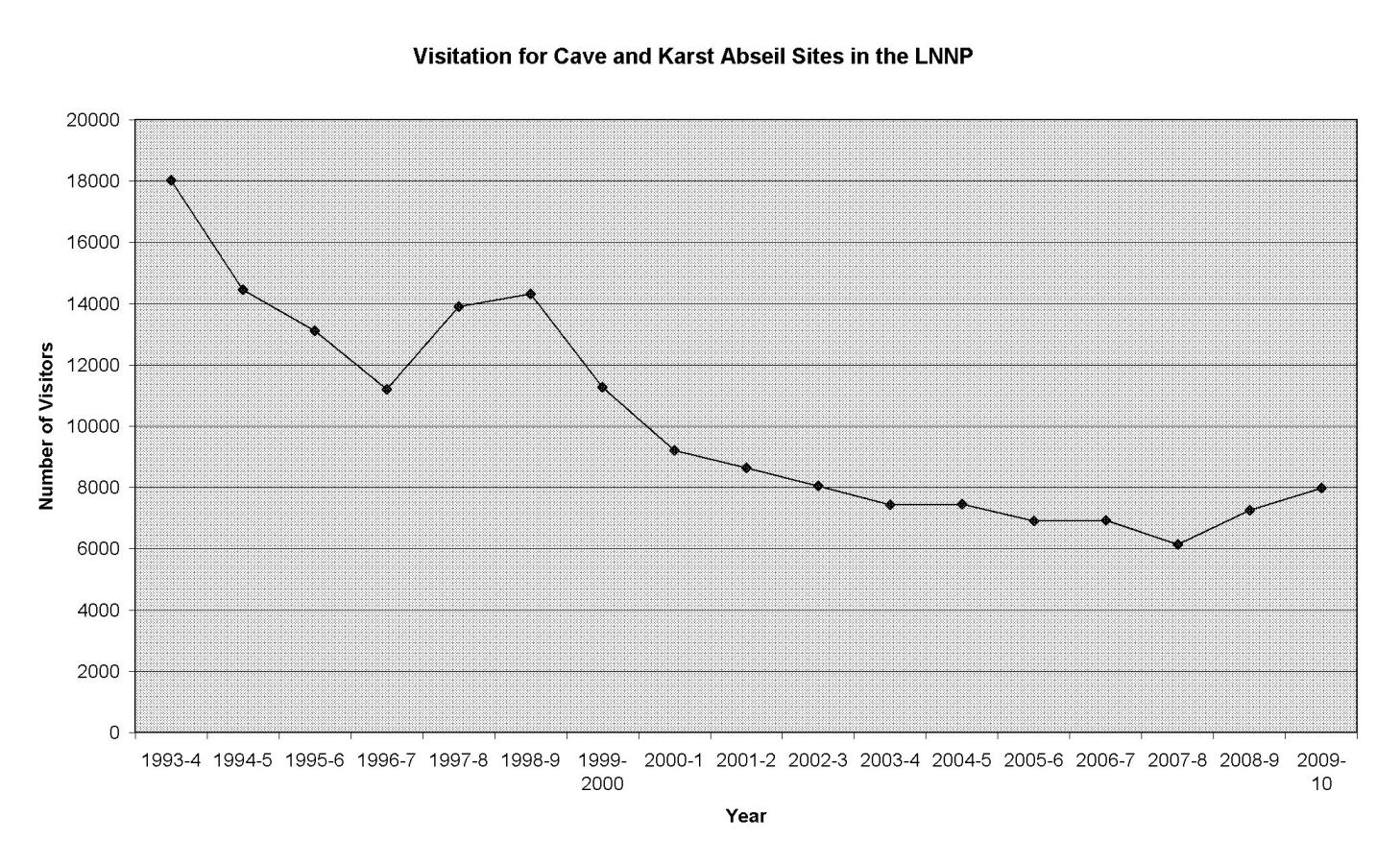
Cave Visitation LNNP (excluding general tourist entry to Calgardup and Giants Caves)
There have been no cave rescues in the last 10 years. The most common sites for rescues in the past were Giants Cave, Bride Cave, and Terry’s Cave. Giants Cave is now track marked, with infrastructure such as stairs and boardwalks through some sections, and people enter under the direction of DEC staff or under the control of an accredited leader. Bride Cave, which is accessed by abseiling, is only available to groups with an accredited leader. Some questionable practices such as star jumping and angel jumping have been banned. Terry’s Cave was popular with commercial adventure tour operators prior to 1992 when the permit system was introduced, but was classified as a restricted access cave and is no longer available for that use.
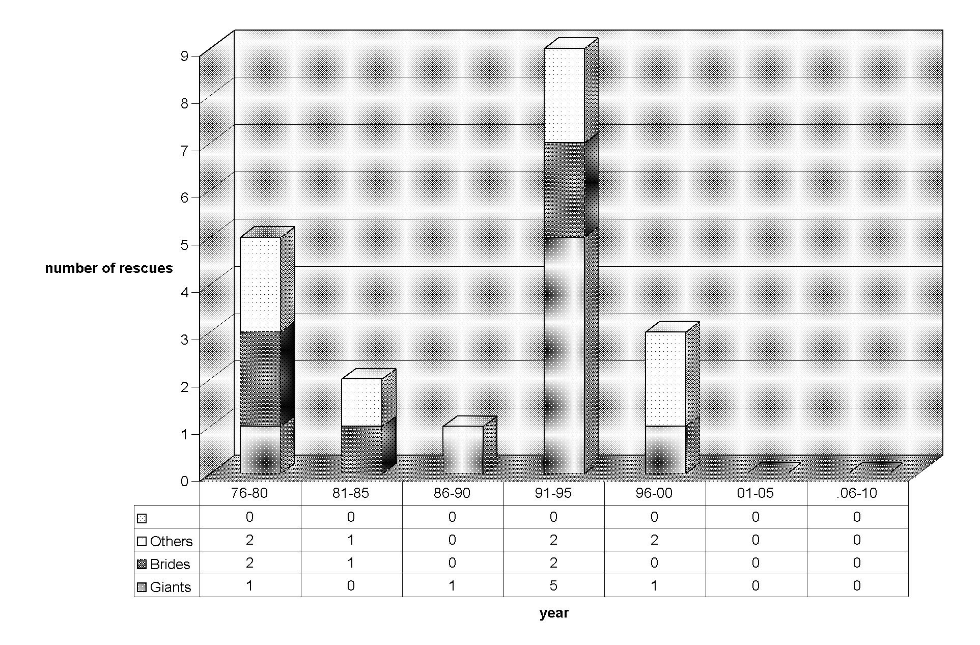
State Emergency Service Cave Rescues (excluding Tourism Association managed show caves). Data from LEMAC of AMR (1999).
On a subjective, qualitative basis it can be claimed that visitor impacts have decreased since the introduction of the Cave and Abseil Permit System and associated initiatives. However there is little quantitative evidence for this. One example is a study of surface vegetation around the entrance of Dingo Cave.
The first time the authors visited Dingo Cave was in the very early 1990’s. After we made our way down from the “pretty” section into the main rock breakdown chamber as we were exiting the cave we encountered about 40 boy scouts. They were swarming like ants over every surface in the chamber and asked if the cave went anywhere else. We replied “no” fairly safe in the belief that they would not find the way on. We made our way up past more scouts and only two adults. After the introduction of the permit system the maximum group size for this cave was set at six people.
|
Compass Bearing |
Extent of Bare Earth (metres) |
||||||||||||||||||||||||||||||||||||||||||||||||||||||||||||||||||||||||||||||||||||||||||||||||||||||||||||||||||||||||||||||||||||||||||||||||||||||||||||||||
|
July 1992 |
April 2011 |
||||||||||||||||||||||||||||||||||||||||||||||||||||||||||||||||||||||||||||||||||||||||||||||||||||||||||||||||||||||||||||||||||||||||||||||||||||||||||||||||
|
0 |
1.7 |
0.0 |
|||||||||||||||||||||||||||||||||||||||||||||||||||||||||||||||||||||||||||||||||||||||||||||||||||||||||||||||||||||||||||||||||||||||||||||||||||||||||||||||
|
88 |
4.0 |
3.0 |
|||||||||||||||||||||||||||||||||||||||||||||||||||||||||||||||||||||||||||||||||||||||||||||||||||||||||||||||||||||||||||||||||||||||||||||||||||||||||||||||
|
90 |
8.5 |
5.0 |
|||||||||||||||||||||||||||||||||||||||||||||||||||||||||||||||||||||||||||||||||||||||||||||||||||||||||||||||||||||||||||||||||||||||||||||||||||||||||||||||
|
115 |
7.4 |
2.8 |
|||||||||||||||||||||||||||||||||||||||||||||||||||||||||||||||||||||||||||||||||||||||||||||||||||||||||||||||||||||||||||||||||||||||||||||||||||||||||||||||
|
120 |
8.8 |
2.7 |
|||||||||||||||||||||||||||||||||||||||||||||||||||||||||||||||||||||||||||||||||||||||||||||||||||||||||||||||||||||||||||||||||||||||||||||||||||||||||||||||
|
140 |
7.5 |
2.4 |
|||||||||||||||||||||||||||||||||||||||||||||||||||||||||||||||||||||||||||||||||||||||||||||||||||||||||||||||||||||||||||||||||||||||||||||||||||||||||||||||
|
180 |
4.2 |
2.0 |
|||||||||||||||||||||||||||||||||||||||||||||||||||||||||||||||||||||||||||||||||||||||||||||||||||||||||||||||||||||||||||||||||||||||||||||||||||||||||||||||
|
210 |
2.8 |
1.9 |
|||||||||||||||||||||||||||||||||||||||||||||||||||||||||||||||||||||||||||||||||||||||||||||||||||||||||||||||||||||||||||||||||||||||||||||||||||||||||||||||
|
250 |
1.8 |
0.0 |
|||||||||||||||||||||||||||||||||||||||||||||||||||||||||||||||||||||||||||||||||||||||||||||||||||||||||||||||||||||||||||||||||||||||||||||||||||||||||||||||
|
325 |
5.6 |
0.0 |
|||||||||||||||||||||||||||||||||||||||||||||||||||||||||||||||||||||||||||||||||||||||||||||||||||||||||||||||||||||||||||||||||||||||||||||||||||||||||||||||
|
350 |
6.0 |
0.0 |
|||||||||||||||||||||||||||||||||||||||||||||||||||||||||||||||||||||||||||||||||||||||||||||||||||||||||||||||||||||||||||||||||||||||||||||||||||||||||||||||
Extent of Bare Earth Surrounding Dingo Cave Entrance
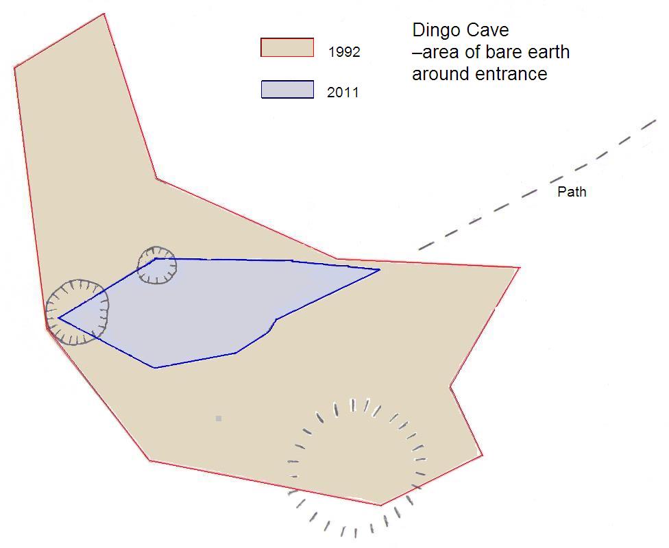
Extent of Bare Earth Surrounding Dingo Cave Entrance
The authors selected this site to carry out a “Limits of change” survey in 1992 (Wood, 1993). Part of this involved measuring the devegetated area around the cave entrance. At this time the bare area surrounding the entrance was extensive. Recent measurements and the accompanying photographs show the vegetation is now quite extensive, covering all but the access path.
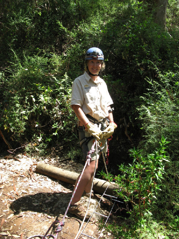
Entrance of Dingo Cave
New Challenges
Given the apparent low rate of non compliance with the permit system over the past few years, the decrease in rescues and the decrease in environmental impacts in many areas it is easy for managers to rest on their laurels.
However many of the emerging generation of cavers were either in nappies or at best primary school when the very hot war regarding access to these cave systems was being debated. Our two decades of an inclusive management culture is seeing the arrival of a generation of computer and internet savvy instant communicators whose initial research into the world of caves involves accessing websites with GPS plugged, ready to download before they pass by their local Anaconda franchise on their way to their latest adventure. The old days of joining a caving group and sitting for 12 months at meetings in awe of those who “held the maps’’ are over.
Allied to this brave new world are the caving groups and the ASF themselves, large portions of whom are promoting and coordinating a national programme, the Karst Information Database or KID, with the object of electronically centralising all cave locations for Trip Leader access. The temporary nature of many individuals affiliation with caving groups is obvious testament of the ability of the whole system to “leak’’.
Many people of course dispute that particular assertion; however the same sort of anecdotal evidence that prompted the initiatives of the early 1990’s is being again witnessed in the LNNP. That is chains at cave gates that have been padlocked being cut with bolt cutters and carefully replaced to appear intact, poorly equipped and untrained groups rigging at vertical sites and the “re-exploring’’ of track marked caves, all in contravention of permit conditions, minimal impact caving codes and other ASF standards. The frequency of such events appears to have increased significantly over recent months. The incident that prompted the topic of this paper occurred in February when four people reported that the gate on a restricted access cave was not locked. These people were not cavers but had a “mate” with a GPS full of cave locations, and they had been visiting several of them. As managers our question is - How many people are wandering around with a GPS full of cave locations and where or from whom do they source this information?
Solutions
So the solutions, which will hopefully be found before we witness any repeat of the random and unacceptable environmental damage of the late 1980’s. The following list of Cave security options is adapted from a table in the DECC NSW Cave Access Policy (2010). Further information on rationale, advantages and disadvantages of each option can be found in that document.
Cave Security Options
- Legislation
- Permit system and/or access policy
- Confidentiality of information (particularly sensitive cave locations)
- Public awareness and education
- Psychological deterrents
- Divert access
- Accompanied access/guided tours
- Isolation/rerouting of tracks
- Installation of remote surveillance/ monitoring
- Camouflage
- Signage
- Built security measures (gates fences and barriers)
Most of the options listed here are in place to varying degrees. The only options not implemented in the LNNP are camouflage and installation of remote surveillance.
Some specific targeted actions include;
- Increase in monitoring. On the premise that knowledge is power we need to get out and find just who is accessing these sites and how they are gaining that knowledge.
- Consultation. On the premise that there may be an organised body of some sort that has contacts with this new generation, or at least some of them. Is it ASF affiliated? Four wheel drive clubs? Geocaching websites? Education Dept? Leaking from commercial groups? After all we are not trying to deny these new lovers of all things karst related any access, we just insist that environmental standards are adhered to and that those standards are seen to be adhered to. We all know that broken calcite and mud deposition is always the result of the previous or next party’s activities.
- Policing. DEC has put regulations in place for fining miscreants in National Parks. Given that there is a system of access and a stream of activity for all levels of activity, and those streams are under near constant review, we must ask; why not apply on the spot fines.
- Increased public education and awareness.
- Digital information. Coming back to our original point. When an information savvy young potential caver enters “Caving south west WA” into a search engine, one option needs to be “Regulatory framework to protect an irreplaceable resource”, with leads onto DEC and other relevant information. All explained clearly and concisely, which is a problem in itself because the system in the LNNP, having been designed to accommodate so many diverse groups, is very convoluted.
On the same subject we personally, and we say personally because it is not any official position taken by DEC or our ASF affiliated caving group, Caver’s Leeuwin [inc], are concerned as to just where the ASF’s drive toward embracing the KID process is taking the rest of us. Please call us old fashioned, it’s a title we sometimes wear with pride, but we thought the system was good, in the security sense, when caving groups zealously guarded cave locations and maps in hard copy. Before every cave location in Australia is divulged to someone who may only be a trip leader or full member of a caving group for 12 months before falling out with that group and walking away with loaded GPS, we should take a good look over the cliff. Although ultimately there’s not much we can do about the information factor in this age, we can deal with the protocols that govern its use. It is ultimately a problem we share with fishermen fighting over fish stocks, miners arguing over mineral deposits, and we could even spare a sympathetic thought for Al Quaida, not to mention the caves and karst features that they were holed up in.
Conclusion
Many of the caves in the LNNP and other karst areas rely on the confidentiality of their location as their prime protection against unauthorised access. In this time of GPS and internet technology it will be a challenge to maintain this protection. The photograph below shows an example of what is at risk.
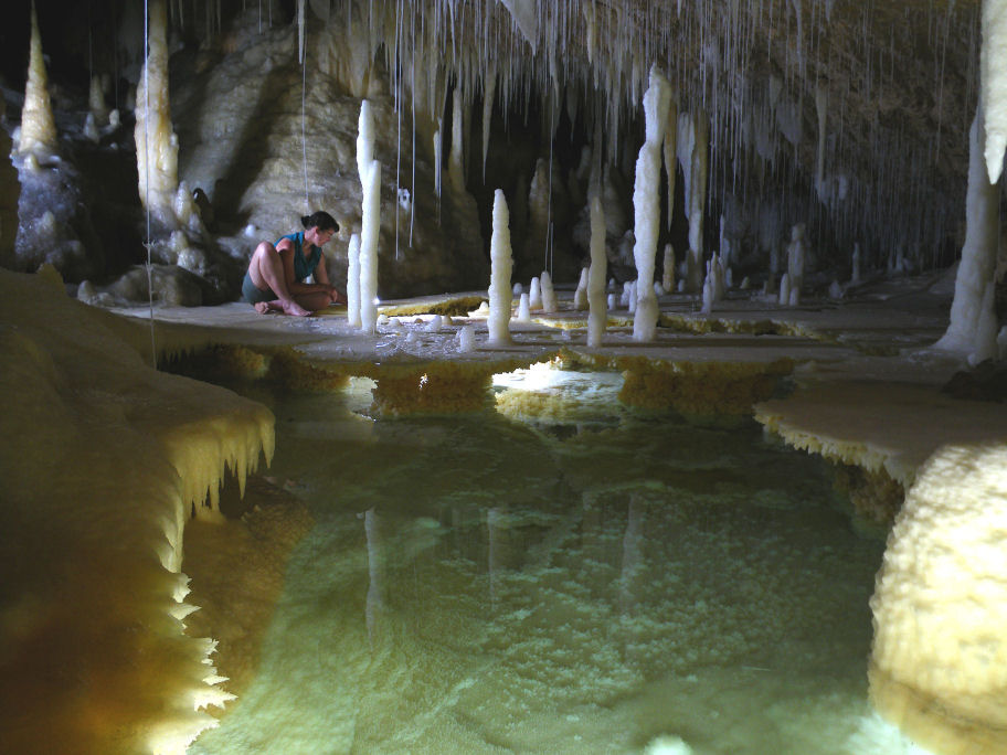
Photo Ross Anderson
Acknowledgements
Ross Anderson provided many of the photographs used in the presentation and figure 5 in this paper
References
DEC (2006). Policy Statement No. 18 – Recreation, tourism and visitor services. Dept of Environment and Conservation, Perth.
DECCW (2010). Cave Access Policy. Dept of Environment, Climate Change & Water NSW, Sydney.
Local Emergency Management Advisory Committee of Augusta Margaret River (1999). Emergency Management Plan: Cave Rescue, 4th Draft (unpublished)
Wood P. (1993) Dingo Cave Limits of Change Survey. In The Western Caver Vol 33. WASG, Nedlands.