Karst in Mid-Proterozoic dolomite, Pungalina Station, Northern Territory, Australia – its significance and management
1Australian Speleological Federation Inc
2Environmental Geoscience, Latrobe University, Bundoora 3068 Australia
Abstract
Extensive karst is reported from several places in Northern Australia in particular Pungalina Station in the Northern Territory. This previously little known dolomite karst area contains significant karst, which has been explored and documented by the Victorian Speleological Association Inc., since 2005. Since the purchase of the property by the Australian Wildlife Conservancy (AWC) in 2008, VSA has continued this work and provides karst knowledge and management advice to AWC.
Introduction
In the published literature, karstification in dolomite (dolostone) is not as well documented as for limestone and as it is less soluble in natural waters than limestone, cave development is generally less. However, extensive karst is reported from several places in the Northern Territory, Australia (White & White, 2009) and the Transvaal, South Africa (Martini et al, 2003). A previously little known karst area, of about 150 km2, in the Mid Proterozoic (Pre Cambrian) stromatolitic and cherty Karns Dolomite on the south-western coast of the Gulf of Carpentaria (N.T.) contains significant karst including caves.
Although the Karns Dolomite was know to geologists, the karst potential had never had any investigation. As a result the karst was not well known until the Pungalina Station owner Owen Davies started operating it as a Safari Operation in partnership with Kirkhope Aviation. Their interest in the caves was as an additional feature to the usual safari activities for tourists. At that stage they knew of one major cave with bats and a few other smaller caves. Since 2005, VSA has undertaken 5 further expeditions to the area, discovering, exploring and mapping a number of caves and karst features.
Access to the area is very dependent on conditions; a heavy summer wet can limit access and movement around the property. VSA trips as a result, have been in June or early July.
Regional Setting
The area is located in the Gulf Coastal bioregion of the Northern Territory (Figure 1) near the Queensland / Northern Territory border and the Savannah Way (Highway 1). The Calvert River flows north through the property and terminates in the Gulf of Carpentaria. The currently known karst is predominantly in the exposed dolostone in the catchment of the Karns Creek, a tributary of the Calvert River.
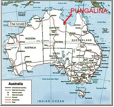
Figure 1. Pungalina location
At about 16°30’ S. latitude, Pungalina has a hot monsoonal climate dominated by distinct wet and dry seasons. The cave temperatures are higher (29-34°C) than the expected yearly average (26.4°C) with cave humidity levels close to 100%. This is possibly due to a combination of summer rain, temperature and the effect of soil heated up by the sun. In some caves, the humidity is such that just moving around causes the moisture to condense as droplets and produce a fog. Some caves flood during the summer monsoonal rains maintaining the high humidity.
The karst areas of the property have a mosaic of open savannah woodland with pandanas and paperbark communities around the creeks and wetlands. Cave entrances often have remnant dry rainforest species not present in the surrounding savannah woodlands. The diverse habitats support a rich fauna.
Geology and Geomorphology
The karst is developed in the Karns Dolomite, a 100-200 m thick cherty dolostone estimated as being between 1.73 to 1.43 billion years i.e. mid Proterozoic (Pre Cambrian) in age. The Karns Dolomite is only intermittently exposed on the surface in this area as it is overlain in some places, by the very late Proterozoic Bukalara Sandstone, isolated outliers of marine Cretaceous sandstone and claystone and Cenozoic sediments and laterite.
The Karns Dolomite was deposited in a shallow marine, tidal environment, characterised by numerous stromatolitic beds dominated by the genus Conophyton (Figure 2). Such shallow, upper tidal environments have a variety of sediments reflecting the variable depositional depths. These include more siliceous and clay rich beds, now evident only either in cave walls or as surface rubble. The dolomite is relatively flat lying and exhibits only shallow dips and small structural deformations. In the upper reaches of Karns Creek, several hills and tabular plateaux are capped with a massive banded chert, brecciated in places and up to 10m thick, which appears to terminate the dolostone sequence which may be a Proterozoic paleosol residual left after the dissolution of cherty carbonates and subsequently cemented together into a massive rock under the effect of diagenesis or very low-grade metamorphism.
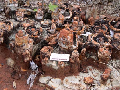
Figure 2. Conophyton stromatolites (S.White)
There is a significant gap in the rock history between the cessation of sedimentation in the late Proterozoic and the Cretaceous when extensive sedimentary deposition of sandstones occurred (~ 400 Million years of record missing). Either the area had no deposition or, as is most likely, any deposition that occurred during the Palaeozoic and early Mesozoic (543 – 146 million years), was minimal and was subsequently completely eroded. There are only small remnants of Cretaceous sediments present, which indicates that the extensive deposition, which occurred, has been subsequently eroded during the Cenozoic. The area has been subjected to more sub-aerial erosion throughout the Cenozoic.
Karst Landscape Development
The geological history indicated that the area was probably covered by sediments in the Cretaceous, but by the end of the Cretaceous, the area was exposed and eroding. Extensive landscape lowering has occurred and remnants of a higher altitude landscape with large streams and high level caves remain on the ridge tops, resulting in a landscape inversion (stream cobbles are found on some ridge tops). Much of the karst has the characteristics of a highly eroded landscape where the present features are the relics of previous conditions.
The major relief of the area is seen in the sandstones outcropping to the south and west of the main karst area. The relative relief of the sandstone areas is high – up to 100 m of incision by the Calvert River in places with striking sandstone cliffs. The relative relief of the Karns Dolomite areas is much lower and flatter. The tops of the ridges are 10- 25 m above the rest of the plain.
At least two periods of karst development on the Karns Dolomite have occurred, and there may have been more. The two karst development periods are an upper/older one, which is preserved as remnants on ridge tops e.g. remnant streams, dolines and caves, and a lower/younger one at the break of slope at the foot of the ridge with currently active caves. Other small karst features include degraded dolines and solutional features.
The upper caves are no longer being actively developed, although minor modification is occurring from surface runoff into the cave and degradation of old speleothems (e.g. the Totem Pole in Totem Pole Cave (PUN 07) (Figure 3) and deposition of newer formation in other parts of the cave. The younger and currently active karst development stage is occurring with the formation and modification of narrow, joint controlled maze like caves lower on the ridges, forming especially where surface runoff drains underground through joints and fractures, at the break of slope near the base of the ridges. These are the main caves in the area and have concentrated areas of decoration and calcite formation, interspersed with extensive areas showing solutional features such as rills. These caves also take extensive water during wet seasons and most have evidence of episodic flooding and active solution. There is extensive evidence in the form of small water sinks and degraded dolines and hollows, that the area was a more impressive karst landscape in the past.
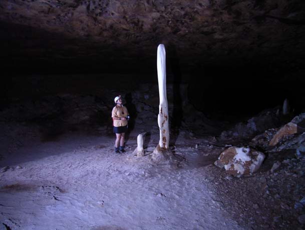
Figure3. Totem Pole Pun 7 (D.Carr)
Preliminary U238/Th234 dates of speleothems from an upper level of a higher level cave, indicate at least two periods of speleothem deposition in the mid Pleistocene and Holocene times (J. Hellstrom, pers. com.). Further work is needed to understand the implications of this.
The surface of the dolostone ridges has extensive karren especially as kamanitzas or pans rather than solutional rills. The stromatolites are often “picked out” by solution.
Modern tufa deposits occur in the bed of a small creek near the present homestead. These indicate that the river is highly saturated in calcium carbonate and at specific places is capable of deposition.
Groundwater outflow points were observed close to Karns Creek and the Calvert River and more must occur during the wet season, as evidence of outflow was found in a few places. The warm ( ~28º C) Bubbling Springs which flow regularly all year round suggest that the ground water flow is slow, buffered by the residual overburden covering the karst as well as by the nature of the wet cave network, which is probably not well integrated.
Caves and karst
Over 50 caves, 20 significant dolines, 2 poljes and several karst springs have been documented. More detailed work is needed.
The caves were initially found from the local knowledge of Owen Davies and subsequently from locations of dolines viewed from the air and from air photos. Since the first expedition, exploration has been by walking to likely places at the break of slope between ridge and plain where there are some discharge caves. On ridges the presence of green vegetation is often associated with sheltered dolines sometimes with caves present.
The caves are generally shallow phreatic, joint and/or bedding plane controlled passage networks. Passage roofs are often flat (Figure 4). Two cave levels can be identified: a dry upper series in the high grounds and residual hills, and an active lower one on the plain and in the valley bottoms. The caves contain aragonite and/or calcite speleothems, sometimes with chert breccia, which show evidence of repeated phases of deposition and re-solution. Chert replacement of the stromatolites has occurred and these are then in relief as the dolostone is dissolved (Figure 5).
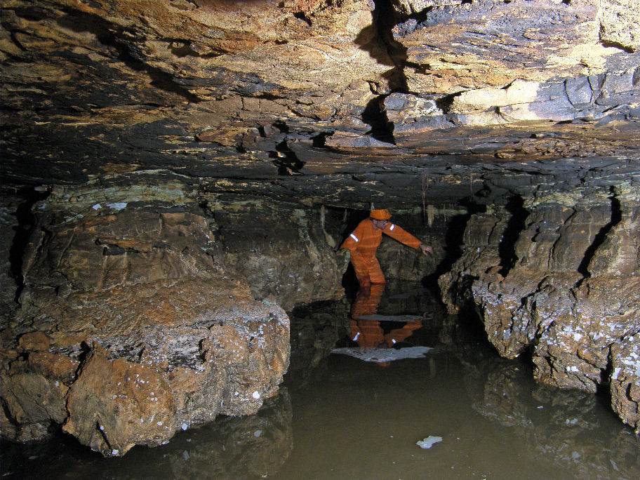
Figure 4. Raft Cave PUN 23 Passage shape (D.Carr)
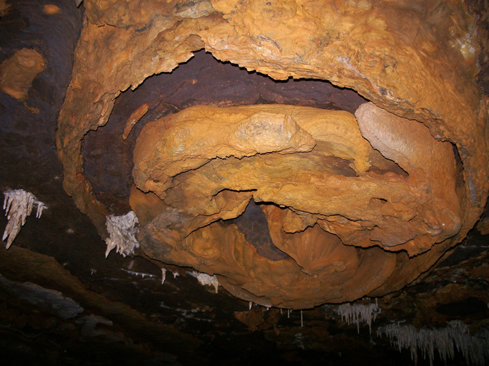
Figure 5. Chert replacement of stromatolite in cave roof, Conyphyton Cave, PUN 36 (D.Carr)
Cave and Karst Values
Extensive solutional karstification is found in dolomite at Pungalina. This is regarded by many karst geomorphologists as unusual, e.g. Ford (2004) states that in dolostone “surface land forms are more limited in type and scale” and that “caves large enough for human entry are quite rare”. This makes the dolomite karst areas of the N.T. such as Pungalina, significant. There is a potentially long time for karst to develop and there is no evidence of intense tectonic activity in this area, although more intense faulting and folding does occur to the west. Some faulting and relatively gently warping has occurred but the dolostones are relatively flat lying. The preliminary information from speleothems indicates that there is significant potential for detailed climatic information to be obtained. This is particularly important as there is a dearth of appropriate sites in the Australian tropics for such work. The presence of a previously unknown colony of Ghost bats (Macroderma gigas) and the presence of large numbers of the rare Orange Leaf-nosed bats (Rhinoncteris aurantius) (Figure 6) indicates important biological values. Initial studies of the invertebrates indicates a predominance of guanophiles (T. Moulds, pers com) but perhaps more work will find other invertebrates. Finally the caves are really spectacular if hot and sticky, but the bubbling karst springs (Bubbling Springs) are a pleasant end to hard caving days.
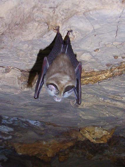
Orange leaf-nosed bat on cave roof, Conyphyton Cave, PUN 36 (D.Carr)
Conclusion
Significant caves and karst have been discovered, explored and documented in a remote area of Australia with difficult access. The whole exercise is an excellent example of how caver initiated exploration and documentation on a series of self funded expeditions can add to the understanding of caves and karst and assist with their management.
Acknowledgements
We acknowledge the help of the following, as without their enthusiasm and contributions this work would not have been possible:
Pungalina Safaris (Kirkhope Aviation & Owen Davies),
Dr J. Helstrom, (University of Melbourne)
Australian Wildlife Conservancy
The Victorian Speleological Association expeditioners 2005 - 2010.
Daryl Carr for photographs
References
Martini J.E.J., Wipplinger P.E., Moen H.F.G. and Keyser A. (2003). Contribution to the speleology of Sterkfontein Cave, Gauteng Province, South Africa. International Journal of Speleology 32(1/4): 43-69
White S. and White N.J. (2009). Bullita Cave, Gregory Karst, N.T. Australia: A Maze Cave in Proterozoic Dolomite. Proceedings of the 15th International Congress of Speleology, Kerrville, Texas, USA August 2009 :1010-1013.
Ford, D. (2004). Carbonate karst. In: Gunn, J. (Ed). Encyclopedia of caves and karst science. Fitzroy Dearborn, New York, London, 184-186.