An Overview of the Mole Creek Karst
1Optimal Karst Management, Denham, Western Australia
2Water Management Branch, Dept. Primary Industries, Parks, Water and Environment, Tasmania
Email: 1 aspate1@bigpond.com 2 Ian.Houshold@dpipwe.tas.gov.au
Abstract
In 1963, Dr J. N. (Joe) Jennings stated to the Australian Heritage Commission that:
Australia as a whole is not well off for karst caves…. The Mole Creek area ranks amongst the most valuable.
It was ultimately listed on the Register of the National Estate in 1983. The Marakoopa section of the Mole Creek Karst National Park was added to the Tasmanian Wilderness World Heritage Area in 1989. It is thus one of the seven Australian World Heritage properties (out of 19 sites) with internationally recognised karst values.
In 2003 the Mole Creek karst was identified by Australia’s leading karst scientists as one of fifteen most significant karst areas in Australia and thus is a candidate for the new Australian National Heritage List.
The Mole Creek karst is also home to a significant population of farmers, foresters and people developing tourism businesses – one of the few parts of Australia where a dynamic karst landscape provides the background to the well-being of the local community. This highly significant place, then, is the host site for the 19th Australasian Conference on Cave and Karst Management.
This paper, which was commissioned by the conference organisers, briefly outlines the values and significance of the Mole Creek karst area, concentrating on the significant surface karst features and on the subterranean systems and their contents. It also touches on the complex cultural features of the Mole Creek karst which include the interests of indigenous people, the development of cave tourism in Australia and the development of scientifically based management.
Introduction
In 1963, Dr J. N. (Joe) Jennings (considered by many as the ‘father’ of Australian karst science) stated to the Australian Heritage Commission that:
Australia as a whole is not well off for karst caves ... The Mole Creek area ranks amongst the most valuable. Indeed it could be argued that it is the most valuable single cave area intrinsically and its comparative nearness to Sydney and Melbourne enhances its value.
It was ultimately listed on the Register of the National Estate in 1983. The Marakoopa section of the Mole Creek Karst National Park was added to the Tasmanian Wilderness World Heritage Area in 1989. It is thus one of the seven Australian World Heritage properties (out of 19 properties) with internationally recognised karst values. The seven are:
- Lord Howe Island;
- Greater Blue Mountains;
- Purnululu;
- Australian Fossil Mammal Sites - Riversleigh/Naracoorte;
- Tasmanian Wilderness;
- Great Barrier Reef; and the
- Ningaloo Coast.
The last, Ningaloo Coast which includes the karst and subterranean biodiversity of Cape Range, has been added since the ACKMA Conference at Ulverstone. This is an important addition to Australia’s World Heritage as the karst and subterranean values are explicitly recognised whilst they are only thought of as components of the other seven.
In 2003 the Mole Creek karst was identified by Australia’s leading karst scientists as one of fifteen most significant karst areas in Australia and thus is a candidate for the new Australian National Heritage List.
The values of the Mole Creek karst comprise components as follows:
- Permian palaeokarst features exposed at the surface and in caves, potential for Tertiary features;
- Glacio-karstic interactions;
- Magnificent calcite, aragonite and gypsum speleothems (Figure 1);
- Comprehensive and well-developed suite of surface karst landforms;
- Complex karst hydrology exhibiting strong structural control;
- Potential warm water and sulphuric acid-driven solution;
- Sub-fossil bone deposits;
- Diverse invertebrate cave fauna;
- Important research record, particularly in geomorphology, hydrology and palaeoclimatic work;
- Highly significant for recreational caving and regional tourism; and
- An important agricultural and timber production area.
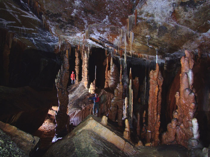
Figure 1. The Forbidden City, Kubla Khan. Photography courtesy of David Wools-Cobb.
Although there has been an extensive history of European use of the caves there appears to be little known about its undoubted importance to the indigenous people of the area. There has been a very large amount of cave exploration and of scientific research. Unfortunately much of the research is reported only in the so-called ‘grey’ literature – that is, not in formally-reviewed scientific literature. Indeed Armstrong Osborne, in a recent review of the origins of caves in the Eastern Highlands of Australia (which, of course, includes Tasmania), stated:
It is noteworthy that the 10 page description by Jennings (1967) of the Mole Creek karst is still the major published account of this important karst area. (Osborne, 2010, p. 293)
Much of the research has been aimed at better understanding the karst hydrology of the area and has been much focused towards better management of this area of mixed tenures and land uses.
Location
The Mole Creek karst is a relatively large area of Ordovician limestone, approximately 45 km in length, between five and ten kilometres wide, located 70 km west of Launceston in northern Tasmania. The karst supports a wide variety of land uses and tenures, including dairying, sheep and cattle grazing, native timber harvesting, tree plantations, and reserves for nature conservation and recreation. The small urban settlements of Liena, Mole Creek, Chudleigh and Meander are located within the limestone area.
Natural Diversity
Geology
The Mole Creek karst is developed in hard, dense and well jointed Ordovician limestone. The rock has been moderately to intensively folded into a series of synclines and anticlines, which generally trend in a NW-SE to EW direction. Similar to the Florentine valley, the limestone immediately overlies hard siliceous sediments, locally called the Moina Group, and is conformably overlain by sandstones and mudstones attributed to the Eldon Group.
Unconformably overlying the limestone to the south are flat-lying Permo-Triassic sediments, which have been intruded by massive Jurassic dolerite sills and dykes. Permian palaeokarst features are common in the vicinity of this contact, extending into caves in some areas.
Tertiary basalts and associated sub-basaltic gravels overlie the limestone on valley floors at Mersey Hill and outcrop discontinuously eastwards to the vicinity of Meander. At Liena, limestone clasts form a breccia within these lavas, indicating an eruptive centre.
Thick deposits of Pleistocene fluvio-glacial gravels overlie the limestone across a large area, becoming progressively thicker towards the east, where limestone outcrops are very limited in the vicinity of Meander.
Surface Geomorphology
The karst landscape consists of broad, solutionally planated valley floors, generally oriented perpendicular to major drainage lines. This illustrates the dominance of solutional rather than mechanical erosion processes in large scale landform development. These east-west trending basins are bounded to the south by stepped topography of the Great Western Tiers, rising to elevations approaching 1400 m at Western Bluff, reflecting the underlying structure of horizontally bedded Mesozoic rocks. Distinctive cliff-lines have developed in columnar-jointed dolerite at the escarpment of the Central Plateau.
The central parts of the karst are divided by an east-west trending anticlinal ridge of Moina Group sandstone, which has remained proud of the overlying limestone as solution reduced base levels. In the west this feature is known as Standard Hill. Towards the east it is known as Long Ridge. A spectacular gorge of superimposition (Sensation Gorge) cuts northwards through this ridge, intermittently draining the Mayberry polje during floods (Figure 2). Further east, dry gaps mark previous courses of Western Creek and the Meander River, displaced by both basalt flows and alluvial fan processes.
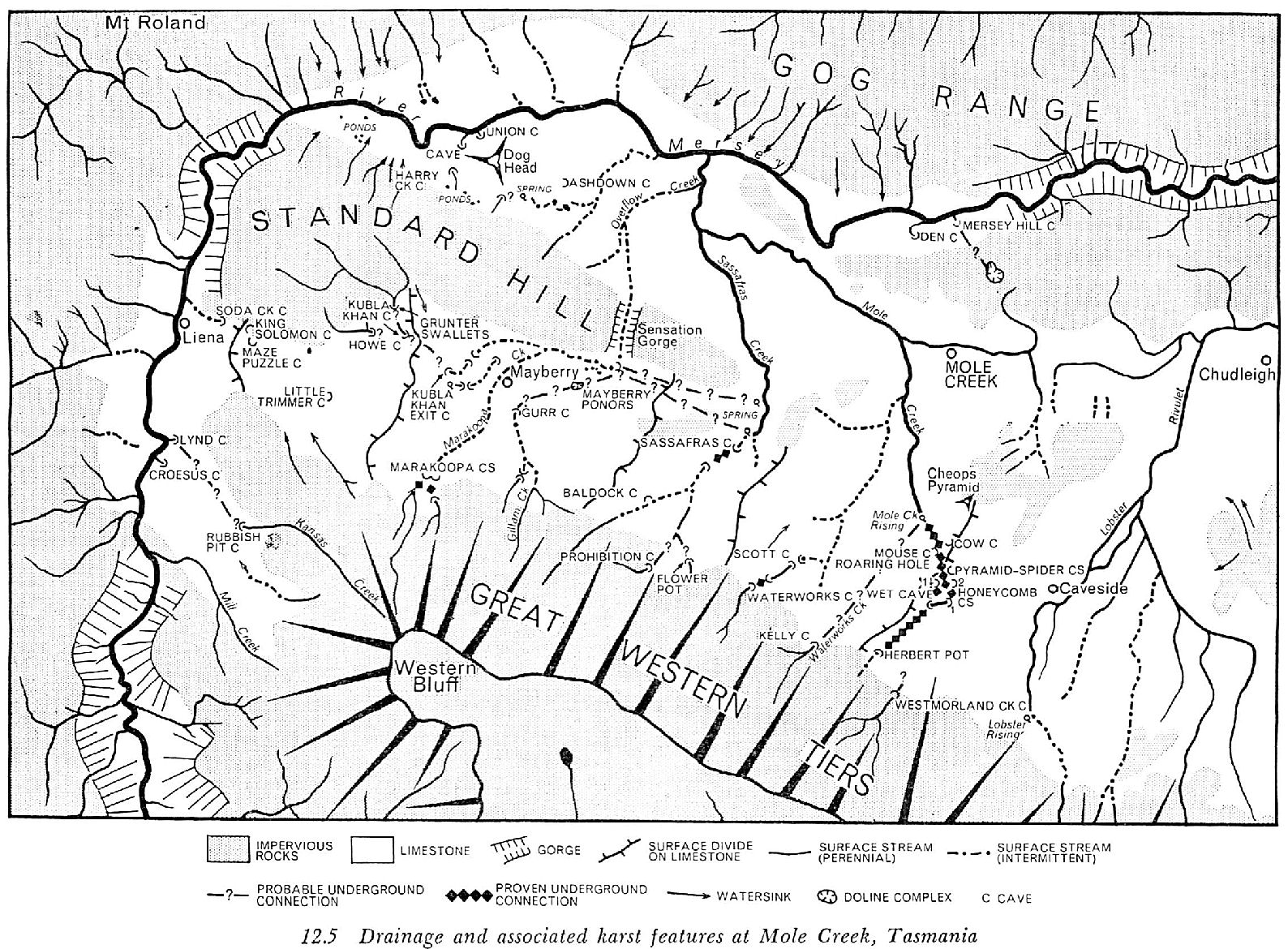
Figure 2. Joe Jennings’ appreciation of the karst at Mole Creek (Jennings, 1967).
Glacial ice has overridden much of the Mole Creek karst in the Pleistocene. High level tills at Liena are found at approximately the same level as King Solomons Cave, which also contains dolerite fragments, potentially derived from meltwater. A high level till deposit at Mersey Hill suggests that, if Plio-Pleistocene in age, the area around Mole Creek township itself was inundated by ice. However it is not certain that this deposit does not underlie Miocene basalts. If this is the case, Tertiary aged glacial deposits and outwash may be present in some of the nearby cave systems. A fascinating study by Treble suggests that the water which deposited speleothems of last glacial age in Marakoopa Cave was most likely derived by seepage from glacial meltwaters (Treble, 2003). Significantly, this is not evident in the current surface topography of the area.
Because of its comparatively large size (in comparison with other impounded karsts of Australia’s Eastern Highlands) the Mole Creek karst contains a wide range of significant surface karst features. Some of the more important features include:
- Large Hums, (residual karst hills) - Dogs Head Hill and Cheops Pyramid.
- Karst margin poljes - the Mayberry and Loatta basins.
- The subjacent karst uvala at Mersey Hill.
- Polygonal karst on the Mayberry/Sassafras divide.
- A wide variety of dolines (closed depressions) including solution, subsidence and collapse features in many areas (Figure 3).
- Blind and semiblind valleys – e.g. Kansas Creek, Marakoopa Creek.
- Dry valleys such as that below Marakoopa 2 Cave entrance and below Westmorland Cave.
- Many distinct streamsinks, generally located at the Permian unconformity - e.g. Devils Pot, Westmorland Cave, Kelly Pot.
- Steepheads - e.g. at Batchelors Spring and Mersey Hill Cave.
- Karst wells (cenotes?) on the plains south of Union Bridge.
- Karst windows such as the unroofed cave between Wet Cave and Honeycomb Cave.
Small-scale surface solution features are comparatively well developed for Tasmania, resulting in part from exposure to direct precipitation in the open woodland or grassland vegetation surrounding exposed rock outcrops. Significant rillenkarren are found on The Grunter, Dogs Head Hill and on north facing slopes at The Den on the Mersey River. Rundkarren are well exposed on the Mole-Lobster divide and in the vicinity of Shooting Star Cave.
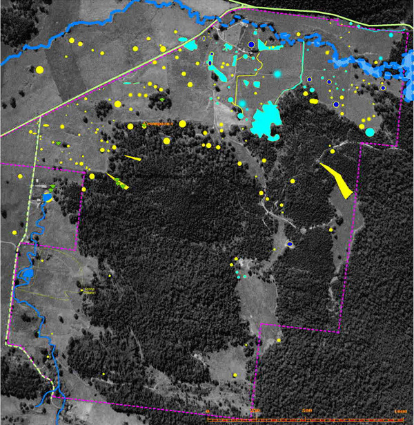
Figure 3. Sinkholes in the north western part of the Mayberry Depression on Circular Ponds property. Yellow = dry sinkhole. Light Blue = Fills with water in winter. Dark Blue = Retains water year round. From: http://www.greatwesterntiers.com.au/ponds/index.htm
Caves and cave contents
Approximately 360 caves have been described from this area. The following is a brief list of the major systems:
- The Mole-Lobster system (Kellys Pot/Westmorland Cave/Herberts Pot/Wet Cave/Honeycomb Cave/Cow-Pyramid Cave).
- The Sassafras system (Prohibition Cave/Baldocks Cave/My Cave/Cyclops Cave/Sassafras Cave).
- The Marakoopa system (Marakoopa 1, Marakoopa 2/Devils Pot/Snailspace Cave).
- The Kubla Khan system (Kubla Khan/Genghis Khan/Kubla Khan efflux).
- The Mill-Kansas system (Hidden Cave/Tatana Magra/Shooting Star Cave/Croesus Cave/Rubbish Heap Cave/Lynds Cave/Rathole/Mill-Tailender Cave).
- The King Solomons system (Execution Pot/Little Trimmer/Lime Pit/Kohinoor/Maze Puzzle/Diamond/King Solomons Cave/Soda Creek Cave).
- Dogs Head-Union Cave system.
- Mersey Hill-Den Cave system.
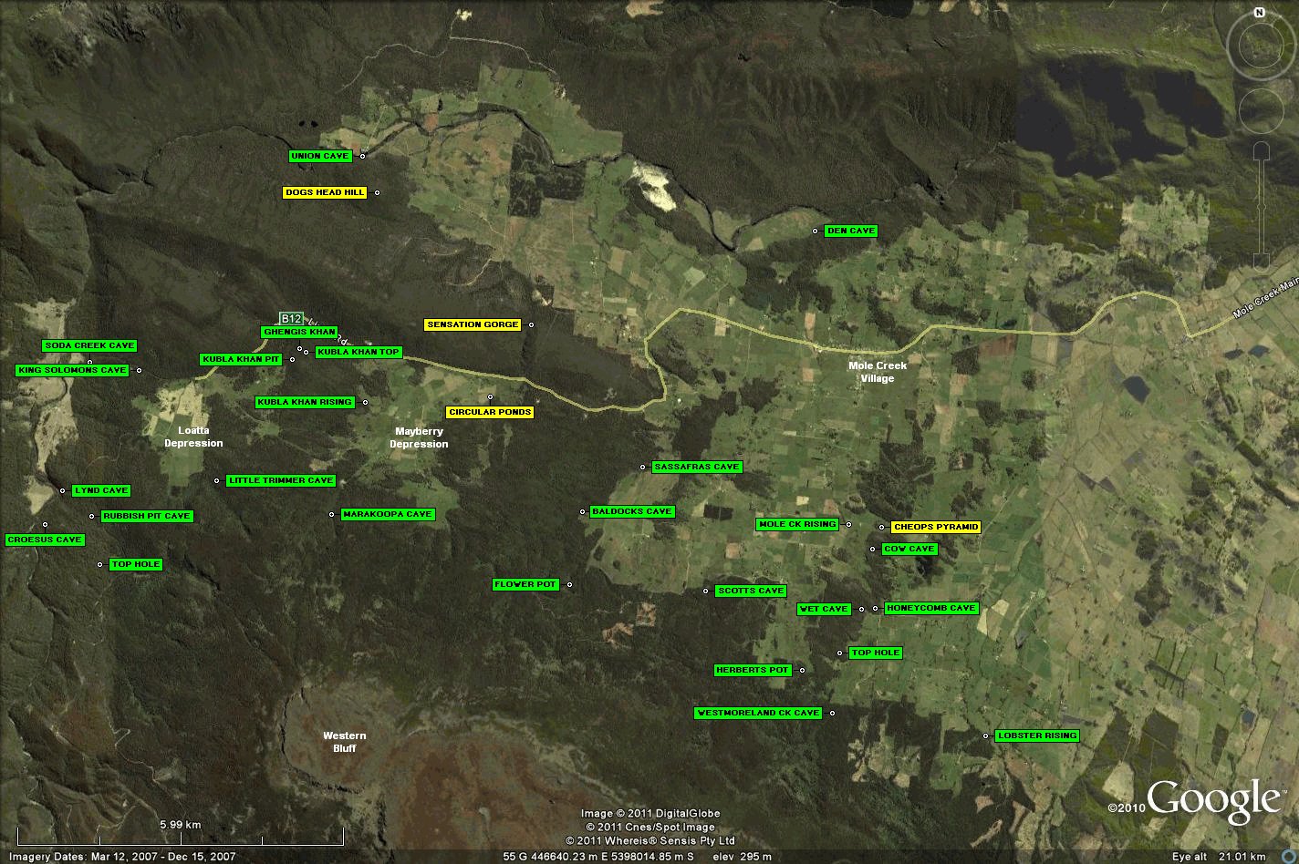
Figure 4. Distribution of the major caves at Mole Creek.
Many caves contain large stream passages developed primarily through vadose solution, including the major Mole/Lobster caves, Croesus, Lynds, Marakoopa, Sassafras and Prohibition caves. Other systems show multiphase development, with distinctive epiphreatic and bathyphreatic forms. Development of many of these forms would require rising water under hydrostatic pressure, and slow-moving, nothephreatic speleogens (Jennings, 1985) are notoriously difficult to separate from speleogens resulting from convectional upwelling of warm waters. The upper levels of Marakoopa Cave exhibit cupolas, vertical shafts terminating in domes, and a massive solutional chamber (the Cathedral) which may potentially have resulted from solution by deep-sourced, warm water. However, they may equally have developed in slow moving, deep nothephreatic systems sourced from meteoric groundwater. Solution by sulphuric acid may be responsible for massive chambers (Xanadu in Kubla Khan, and Stargazer Chamber in Shooting Star) where sulphide-rich palaeokarst sediments are found. Once drained, salt wedging (gypsum) processes in both of these caves has continued stoping roofs and walls.
The Mole Creek caves are internationally famous for their spectacular speleothems, comprising many different forms of calcite, aragonite and gypsum. Kubla Khan, Croesus, Marakoopa, King Solomons and Shooting Star Caves, Herberts Pot, Mersey Hill and Shish Kebab Cave contain the most diverse and well developed suite of speleothems in Tasmania and potentially in Australia. Kubla Khan (including Ghengis Khan) is renowned for its range of calcite, aragonite and gypsum forms, both in scale and extent (Figure 5). Croesus Cave contains a spectacular set of gours, almost one kilometre in length, along its main streamway. These gours contain large masses of nodular concretions, similar to cave pearls but far more coarsely crystalline. Shooting Star Cave contains massive aragonite flowers, extensive frostwork and extensive deposits of gypsum hair and flowers. Gypsum is also spectacularly displayed in Herberts Pot and Mersey Hill Cave, with spectacular aragonite in Shish Kebab Cave.
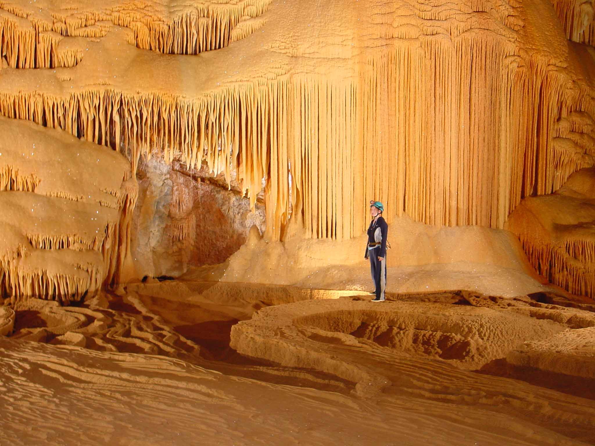
Figure 5. The Pleasure Dome, Kubla Khan. Photograph courtesy of David Wools-Cobb.
Many Mole Creek caves contain fluvio-glacial sediments derived from invasive meltwater streams. Croesus and Lynds Caves, Marakoopa 1 and 2 and Kubla Khan are excellent examples. Massive diamictites composed of angular dolerite boulders up to 2 m in diameter are found in Marakoopa Cave, most likely derived from mass movement of slope deposits in the catchment. These are likely to be related to regional periglacial processes during the last glacial stage.
Significant bone deposits are found in the caves, including owl-roost deposits in caves in the Sassafras area. Much bone material was excavated from red earth in King Solomons Cave during track development, with extinct megafauna being recorded. Pig Sty Cave and Kutna Hora also contain bones from megapodes no longer inhabiting the district.
Hydrology
The Mole Creek karst is hydrologically complex, with mature subsurface drainage networks commonly breaching apparent surface divides. This drainage modification has been determined by rock structure in combination with the effects of surficial sediments (Kiernan, 1984, Figure 6) (and potentially basalt flows) throughout the Cainozoic. It is very common for the larger caves in the district to be oriented along the strike of limestone beds, whilst surface valley morphology has been primarily controlled by the hydraulic gradient of streams. This has produced a generally N-S direction for surface valleys in response to the uplift of the Western Tiers, compared with primarily NW-SE orientations of major cave passages.
Glacial and periglacial deposits have blocked cave passages in some systems, returning streams to surface flow in glacial stages, and re-excavating passages in wetter, more stable interglacials (e.g. Marakoopa Cave). In other areas (the Mole-Lobster system for example) fluvioglacial and periglacial deposits have deflected drainage onto valley margins to develop peripheral channels and subsequently caves (Jennings & Sweeting, 1959).
Subsurface drainage divides are often very difficult to define, as at times they occur under the floors of solutional basins. The divide between the Kubla Khan drainage and Soda Creek system is likely to be rapidly changing as cave systems are captured underground. Subsurface divides in the Mill-Kansas area are similarly complex, as Croesus Cave waters have not yet been totally captured by the Lynds and/or Mill/Tailender systems.
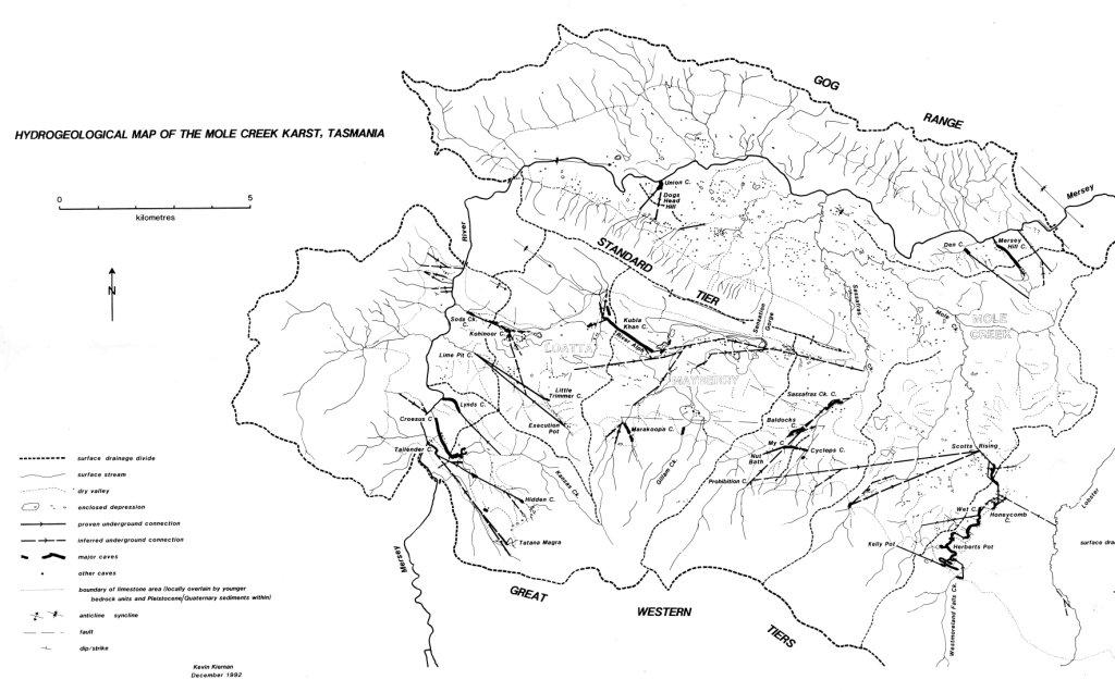
Figure 6. Hydrogeology of the Mole Creek karst (Kiernan, 1984).
Biodiversity
Cave fauna
The Mole Creek karst contains a diverse invertebrate cave fauna, with over 80 species recorded. Three species are known to be endemic to the area, Tasmanotrechus cockerilli (cave beetle), Hickmanoxyomma gibbergunyar (cave harvestman) and Pseudotyrannochthonius typhlus (cave pseudoscorpion). All three species are listed as rare under the State Threatened Species Protection Act 1995.
Baldocks Cave is considered to be particularly important for protection of these threatened species, as all three are present there. The cave is also the type locality for the Tasmanian Cave Spider, Hickmania troglodytes.
Kubla Khan Cave contains the highest diversity of invertebrate species recorded in Tasmania, with 71 species present.
Surface fauna
Along with a wide range of common marsupials and rodents, the mole Creek area is habitat for many bat species, some which use the entrances of caves. The Tasmanian Devil (Sarcophilus harrissi) and Eastern barred bandicoot (Parameles gunnii gunnii) are listed as vulnerable under the Threatened Species Protection Act 1995.
Boobook Owls (Ninox novaeseelandiae) have been recorded roosting in cave entrances. The area is also habitat for two raptors listed under the Threatened Species Protection Act 1995, the Wedge-tailed Eagle (Aquila audax fleayi) and the Grey Goshawk (Accipter novaehollandiae), both of which are endangered.
Surface flora
The predominantly flat-lying country with deeper soils (primarily developed on fluvioglacial materials) was cleared for agriculture from the 1850s onwards. Significant forestry activity has been undertaken since the beginning of the 20th Century. Most of the lowland environment is therefore considerably modified from natural. Small cave reserves (now part of the disjunct Mole Creek Karst National Park) provide refuge for native plant species within this context. More contiguous areas of native forest and woodland are found on the mid to upper slopes of the karst area and its catchments, although some of these areas on private land are currently being converted to tree plantations.
Habitats range from alpine herbfield and grasslands on the Central Plateau to the south, through sub-alpine woodlands, grasslands and stunted rainforest, to tall wet sclerophyll forests dominated by Eucalyptus obliqua, E. delegatensis and E. regnans on the mid slopes of the Western Tiers. Limestone outcrops generally support grassy forest dominated by E. viminalis. Lower marshy areas support E. ovata, whilst drier slopes of the internal, sandstone ridges carry open E. amygdalina woodland.
Dolines form refugia for lowland rainforest species Nothofagus cunninghamii, Atherosperma moschatum, Pittosporum bicolour and Monotoca elliptica. Numerous fern species are common in dolines and damp gullies.
Some drowned dolines contain striking peatlands dominated by Sphagnum falcatulum. These are very rare communities and are dependent on the maintenance of groundwater hydrology.
Six species are listed under the State Threatened Species Protection Act 1995: Acacia mucronata var dependens (rare), Desmodium gunni (vulnerable), Epacris exserta (vulnerable), Glycine microphylla (vulnerable), Pimelea pauciflora (rare), Pomaderris phylicifolia (rare). E. exserta is also listed under the Commonwealth Environmental Protection and Biodiversity Conservation Act 1999 as endangered.
Cultural diversity
Aboriginal heritage
Surprisingly little archaeological research has been undertaken in the Mole Creek area, with no formal record of Aboriginal cultural material from the caves. Historical records show that large ochre mines in the Gog Range to the north of the karst were important sites, and that the majority of people lived in and used the resources of the Mersey Valley. The Honeycomb Cave area is important to contemporary Aboriginal people living in the Mole Creek area. Hunter (2008, citations removed) states:
The country of the Pallittorre Aboriginal people was not an untamed land hosting passive human inhabitants. British colonists of the 1820s remarked on the “luxuriant pastures” of the “extensive plains” of the district. This was the character of the landscape that resulted from careful management practices of the Aboriginal custodians of the land. Grasslands or meadows were maintained by traditional burning practices, interspersed with copses and woods, lightly burned. The landscape was managed to sustain the hunter-gatherer lifestyle and to keep back the forest that was spreading over the island as the climate warmed and became more humid after the most recent ice age.
The study area has been frequented by Aboriginal people since at least the end of the last ice age, if not much earlier. Their permanent settlement of the district commenced about 3,500 years ago (Hunter, 2008). A network of pathways was established by the Aborigines along the base of the Tiers, south over the Tiers, north over the Gog Range and north-east to Port Sorell, for the purposes of trading, ceremony and hunting.
European heritage
Early European settlement of the Mole Creek area was related to the development of the Van Diemens Land Company road through the karst area in 1827. Parts of this road’s original formation still survive in the Liena area, whilst the main road from Mole Creek past King Solomons Cave follows the original alignment. Not long after, important caves such as Wet Cave, Honeycomb Cave, Sassafras Cave and Cyclops Cave were discovered.
Wet Cave was used for commercial tourism from these early years intermittently to the present day. King Solomons and Marakoopa Caves were discovered in the early 20th Century, and today from the centre of the district’s tourism industry, attracting over 40,000 people per year.
Hunter (2008, citations removed) states:
The colonists arrived with their stock in the early 19th century along Pallittorre pathways, to settle the “Westward”, a general term for the area around and west of Deloraine (to Mole Creek), establishing several large agricultural estates. The large colonial estates included Wesley Dale in the Mole Creek valley. However, it was during the subsequent phase of colonisation by smallholders in the second half of the 19th century that the transformation of the landscape began in earnest, as small bush blocks were cleared in the valley. Agriculture diversified, coinciding with the Victorian goldrush of the 1850s, the rapid growth of the Australian colonies and increasing demand for primary produce. A new rural community arose in the district, as small holdings were purchased and forged into farms across the Mole Creek valley. The pathways from the valley up onto the Tiers have been used subsequently for recreation, fishing, hunting, trapping and snaring.
The first Europeans to record caves of the area was a group of surveyors working on a rail route to the west coast in the 1830s. Some caves of the study catchment were known and at least partly explored in the 19th century. Soon after the turn of the century, the present show caves, Marakoopa and King Solomons Caves, were discovered and their potential quickly appraised. The Tourism Department had purchased several blocks of land containing cave entrances by the 1920s to allow for dedicated tourism use. The former show caves Scotts and Baldocks were closed early last century due to discolouration of the decorations by smoke from acetylene lighting. The famous James Wiburd from Jenolan made several visits to Tasmania to advise on cave lighting and development. A memento of his visit is held in the Queen Victoria Museum in Launceston (Figure 7).
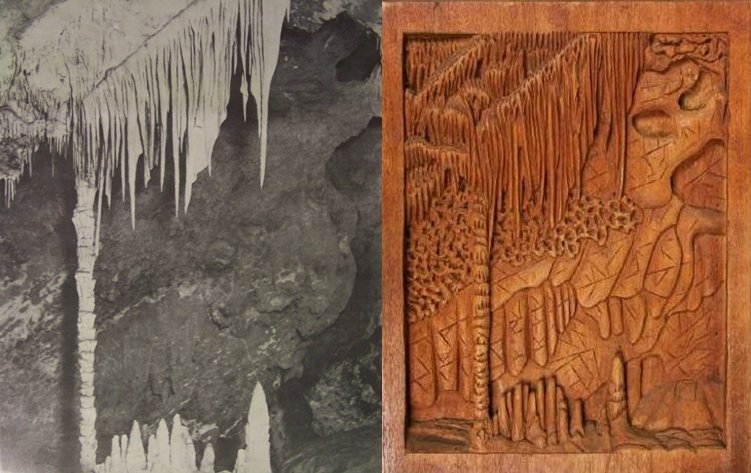
Figure 7. The Palm Tree, Marakoopa Cave. Left: Photograph by James Spurling III, 1911. Image courtesy of Nic Haygarth. Right: Carving on hardwood by James Wiburd, 1917. Photo courtesy of & copyright by: Queen Victoria Museum and Art Gallery Tasmania, and Parks and Wildlife Service, Tasmania.
Prior to development of these caves, Scotts and Baldocks Caves were developed for tourism, involving the excavation of massive quantities of cave earth and gravel to provide access. Lighting was provided by acetylene generators. Scotts, Baldocks and King Solomons Caves all preserve remnants of these carbide lighting systems, considered some of the best preserved examples of early Australian cave illumination (Figure 8).
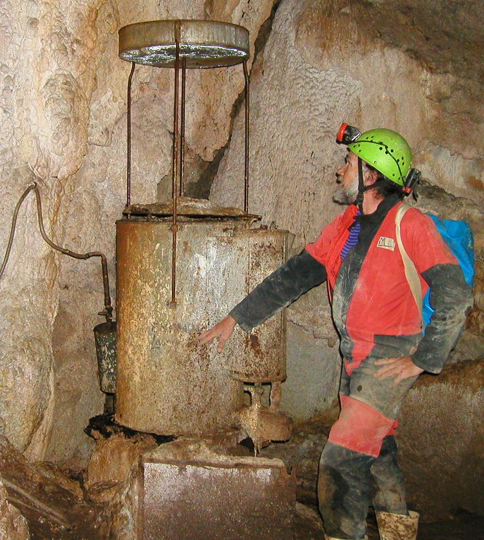
Figure 8. Acetylene generator, Scotts Cave. Photograph courtesy of Deborah Ward.
Much of the early agricultural development of the district was constrained by karst hydrology, with the plains between Caveside and Chudleigh frequently inundated in winter as karst springs overtopped, but bone dry in summer as water tables rapidly dropped though drainage into karst systems. Elaborate drainage networks were excavated, often by convicts. Ironically, equally elaborate water supply systems were necessary to supply dairy herds in summer months. The ‘nine-foot’ channel was created by constructing a water race around the entrance to Westmorland Cave (which previously engulfed all of the Westmorland Creek flows), providing a water supply to lowland farms. Similar systems were developed on the Lobster Rivulet and, later on Kansas Creek. A large fluid-bed landslip down the Westmorland Creek valley in 2010 has resulted in almost complete return of subsurface flows to the previous dry valley below Westmorland Cave, frequently inundating farmland, and now requiring a complex management response to maintain both agricultural and natural values (see Hunter, this volume).
Aesthetic values
Mole Creek combines a patchwork of farms, small settlements, plantation forestry and reserved lands on the flat valley floors with densely forested slopes rising to the spectacular cliffed escarpment of the Central Plateau.
Spectacular surface features such as the Devils Pot, limestone cliffs in the vicinity of Liena, the Mersey Gorge at Alum Cliffs, Westmorland Falls, Lobster Falls and Sensation Gorge are scenic attractions in their own right.
The Mole Creek caves, both the tourist caves and wild caves, are nationally famous for their speleothem displays. Kubla Khan, Croesus, Shooting Star, Lynds, Marakoopa and King Solomons Cave are outstanding. Glow-worm displays in Marakoopa Cave, whilst not as spectacular as those at Ida Bay, are nonetheless a significant attraction.
Scientific research
The karst system has received a moderate amount of scientific attention, including on geomorphology (Jennings, 1967; Jennings & Sweeting, 1959; Jennings & James, 1967; Kiernan, 1984, 1989), hydrology (Kiernan, 1984; Eberhard & Houshold, 2002), cave sediment studies (Burns, 1960; Kiernan, 1984; Goede & Harmon, 1983; Treble, 2003), water chemistry (Kiernan, 1984, 1989; Eberhard & Houshold, 2002), and palaeoenvironmental reconstruction (Goede, 1981; Goede et al, 1982, 1986, 1990). An expanded list can be seen in the References and Bibliography below. Unfortunately, as Osborne (2010) points out much of this important material is in the so-called ‘grey’ literature.
Tourism and recreation
The two show caves (Marakoopa and King Solomons) are the district’s most important tourist attraction, although privately run, commercial wild cave tour operations are becoming popular. Around 40,000 visitors come to King Solomons and Marakoopa caves each year.
The caves have long been very popular with local, mainland and international cavers, primarily because of their spectacular speleothem displays. A trip through Kubla Khan or Croesus Caves at Mole Creek is considered a privilege as access to these fragile systems is restricted to 72 and 154 people annually.
Management
Management of the Mole Creek karst is fraught with difficulties given the range of land uses and tenures – let alone the complexity of the karst systems with their overprints of glaciation, erosion, sediment deposition and landscape evolution generally. Issues include:
- Multiple tenure types;
- The fragmented nature of the Mole Creek Karst National Park (MCKP) –12 widely separated blocks in no way related to hydrologic systems;
- Agriculture (and associated land and water management issues);
- Forestry – in both native and plantation forests;
- Limestone mining, particularly with the potential for future developments;
- Tourism;
- Urbanisation; and potentially
- Climate change.
Fortunately much of the work of Kiernan and others has been directed at understanding the systems, improving management practices on reserved lands and on other tenures and in extending the reserve system. The references and bibliography below give an indication of the scope of work so far. There is probably a better understanding of the management needs – and of the systems themselves – than in any other karst area in Australia. The scope of management related documentation extends from basic science (e.g. water quality studies for Mole Creek; Eberhard & Houshold, 2002) through to management plans for individual caves (e.g. Kubla Khan; Spate, 1991) to approaches for whole hydrologic systems across differing tenures (e.g. for the Mill-Kansas system).
In a probable Australian ‘first’ the Meander Valley Council has commissioned a study by a karst professional leading to a Planning Scheme zoning the Mole Creek karst part of the Council area in terms of karst sensitivity (Figure 9).
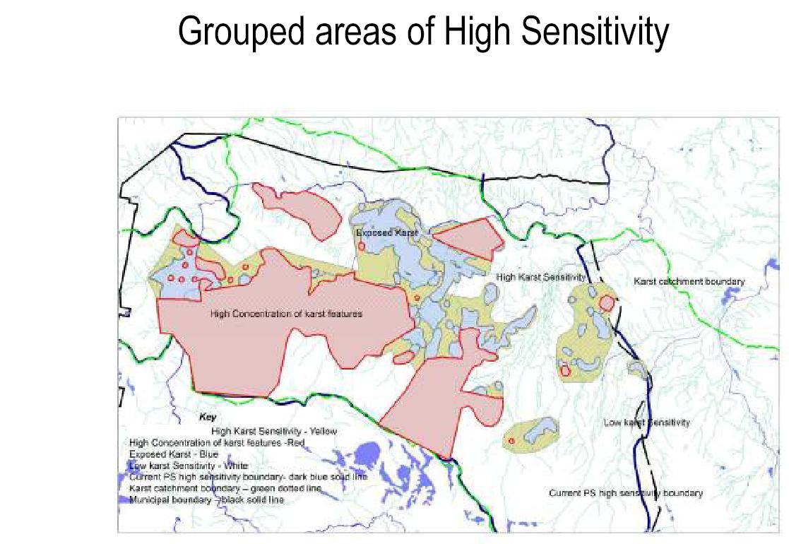
Figure 9. Meander Valley Council’s 2008 Planning Scheme – high sensitivity karst areas.
Another initiative to be applauded includes the activities of the local karst care group – carrying out restoration and track marking in caves and vegetation replanting on the surface. Natural Resources Management North, in conjunction with the Australian Government, have recently published an excellent booklet titled Living on Karst: A guide to Understanding Our Karst Landscapes. This twelve page booklet is perhaps the best example of this type of community-directed information that we have seen.
Assessment of significance
Nothing that has happened since Jennings’1963 statement quoted above has lessened the undoubted significance of the Mole Creek karst. Indeed, at a meeting of karst specialists convened by the Commonwealth Department of the Environment, Water, Heritage & the Arts in 2006, Mole Creek was identified as one of 15 most important karst sites across the continent (Ambrose et al, in prep). Its inclusion in the Tasmanian Wilderness World Heritage Area gives it a measure of international significance – although the karst values of Mole Creek are not explicitly listed in the World Heritage documentation. The levels of significance of the Mole Creek karst can be summarised as follows:
- Evolutionary history – National
- Rare features and processes – National
- Representativeness – National
- Research – National
- Beauty and grandeur – National
- Cave tourism – Regional
- Speleology – National
- Economic - State
Comparable Australian systems
As with the Junee-Florentine system, the Mole Creek karst should logically be assessed in the context of all other impounded karst systems of the Eastern Highlands and associated basins of Australia. Similar lithology and rock structure, climate and palaeoenvironmental history to that of many of the karst systems from the Sydney Basin south sets a logical context area for comparison. Whilst the Junee-Florentine area possesses the most complex and best developed subsurface hydrological system it is likely that Mole Creek contains the best developed suite of surface karst landforms in this context. The karst areas in the southern part of the Lachlan Fold Belt on the mainland do not have the hydrologic dynamics and complexity of Mole Creek.
In terms of its evolutionary history, palaeokarst deposits at Mole Creek are recognised, but have not been researched. The proximity of the karst to Permo-Triassic sediments, often directly overlying an erosional surface on limestone, makes palaeokarst deposits highly likely to be widespread. Solution by hydrothermal systems and sulphuric acid rich waters may have produced some karst landforms and cave passages. Whilst these values are currently speculative, glacio-karstic interactions at Mole Creek are proven, and probably the most significant in the country. Prof Joe Jennings wrote:
…glacial moraines reach very close to the caves so there is a good possibility here of unravelling the effects of glacier advance and retreat on cave development in a manner for which the opportunity appears rare in Tasmania and is nowhere present on the mainland. The opportunity in this particular direction is, I think, greater than at Exit Cave near Ida Bay. (Jennings, 1980)
The diversity, scale and quality of calcite, aragonite and gypsum speleothems in the Mole Creek caves is nationally significant, comparing well or better than similar karst systems elsewhere in the Eastern Highlands.
Acknowledgements
This paper was specifically commissioned by the convenors of the Nineteenth ACKMA Conference. Many contributed ideas, encouragement and images. These include Cathy Plowman, David Butler, David Wools-Cobb, Deb Hunter, Nic Haygarth, Arthur Clarke, Greg Middleton and Chester Shaw. Our sincere thanks to these and any others we may have inadvertently omitted. Special acknowledgement should go to Kevin Kiernan for his thorough and detailed analysis of the Mole Creek karst over many years. We also sincerely acknowledge the work of numerous cavers, scientists and natural historians who have been drawn to this fascinating landscape and given freely of their time in exploration, documentation and interpretation, it is by “standing upon the shoulders of giants” many cavers and scientists provided a platform for Kevin, and, indeed, ourselves.
References and partial bibliography
Ambrose J., Spate, A. and Thurgate M. (in prep). Outstanding Karst Sites of Australia: Proceedings and Technical Report of the National Framework for Karst Values Workshop, 2006, Heritage Division, Department of the Environment, Water, Heritage & the Arts, Canberra
Balmer J., J. Whinam, J. Kelman, J.B. Kirkpatrick and E. Lazarus. (2004). A Review of the floristic values of the Tasmanian Wilderness World Heritage Area. Nature Conservation Report 2004/3, Department of Primary Industries, Water and Environment. Tasmania. pp 129.
Bunton S. and R. Eberhard. (1984). Vertical Caves of Tasmania: A Caver s Guidebook, Adventure Presentations, NSW. pp 81.
Burns K. (1960). Cave deposits in Marakoopa Cave. Bulletin of the Tasmanian Caverneering Club, No.4 p31-36
Burns K., and A. Rundle. (1958). The Geology of the Mole Creek Caverns. Bulletin of the Tasmanian Caverneering Club, No. 1(3) p 3-8.
Burrett C. and A. Goede. (1987). Mole Creek - A Geological and Geomorphological Field Guide. Geological Society of Australia, Tasmanian Division, pp 21.
Clarke A. (1999). Baldocks Cave: The site locality for the Tasmanian Cave Spider and selected historical references relating to the early discovery of limestone in northern Tasmania and the caves of the Chudleigh (Mole Creek) area. Cave Management in Australasia 13: Proceedings of the Thirteenth Australasian Conference on Cave and Karst Management; ACKMA Inc., pp 158.
Dixon G. and N. Duhig. (1996). Compilation and Assessment of Some Places of Geoconservation Significance. Tasmanian Regional Forest Agreement Environment and Technical Heritage Committee.
Dixon G., C. Sharples, I. Houshold, M. Pemberton and R. Eberhard. (1997). National Estate Values (Geoconservation): Conservation Management Guidelines for Geodiversity. Report to the Tasmanian Regional Forest Agreement Environment and Heritage Committee.
Eastoe C.J. (1979). Geological Monuments in Tasmania. Geological Society of Australia Inc. Tasmanian Division, (Reprinted 1986).
Eberhard R. (2003). A Few Thoughts on some Tasmanian Issues. ACKMA Journal. No. 52. ACKMA Inc.
Eberhard R. and Houshold I. (2002). Water quality in karstlands at Mole Creek, Tasmania, Papers and Proceedings of the Royal Society of Tasmania, Vol.136 p 159-172.
Eberhard R. and I. Houshold. (2001). River management in karst terrains: Issues to be considered with an example from Mole Creek, Tasmania.; in Rutherford. F. Sheldon, G. Brierley. & C. Kenyon (eds). Third Australian Stream Management Conference. p 197-203.
Eberhard R. and I. Houshold. (2002). Water quality in karstlands at Mole Creek, Tasmania. Papers and Proceedings of the Royal Society of Tasmania. Vol. 136, p 159-172.
Eberhard S.M. A.M.M. Richardson, and R. Swain. (1991) The Invertebrate Cave Fauna of Tasmania. University of Tasmania, Hobart.
Gams I. (1978) The Polje: the problem of its definition. Zeitschrift für Geomorphologie, Vol. 22. p 170-111.
Goede A. (1981). Variation in the hardness of cave drips at two Tasmanian sites. Helictite, Vol. 19(2) p 56-76.
Goede A. and R. Harmon. (1983). Radiometric dating of Tasmanian speleothems – evidence of cave evolution and climate change. Journal of the Geological Society of Australia. Vol. 30 p 89-100.
Goede A., D.C. Green and R.S. Harmon. (1982) Isotopic composition of precipitation, cave drips and actively forming speleothems at three Tasmanian cave sites. Helictite, Vol. 20(1) p 17-27.
Goede A., Veeh H.H. and Ayliffe L.K. (1990). Late Quaternary palaeotemperature records from two Tasmanian speleothems, Australian Journal of Earth Sciences, Vol. 37 p 333-342.
Goede, A., Green D.C. and Harmon R.S. (1986) Late Pleistocene palaeotemperature record from a Tasmanian speleothem, Australian Journal of Earth Sciences, Vol. 33 p 267-278.
Hunter D. (2008) Slope Hydrology, Karst Drainage and Water Quality Related to Land Use: Great Western Tiers, Tasmania. Unpublished Honours Thesis, University of Tasmania.
Jennings I.B. and K.L Burns. (1958). Middlesex; Geological Atlas 1 Mile Series. Geological Survey of Tasmania. Department of Mines, Hobart.
Jennings J.N. (1967). Some Karst Areas of Australia in J.N. Jennings & J.A. Mabbutt (eds). Landform Studies from Australia and New Guinea, Australian National University Press, Canberra, p 256-292.
Jennings J.N. (1985). Karst Geomorphology, Basil Blackwell, Oxford, pp 293.
Jennings J.N. (1980). The Problems Of Cavern Formation. ASF Newsletter 7.
Jennings J.N. and B.N. James (1967). Underground Water Movements in the Lobster Rivulet Mole Creek Divide Tasmania. Australian Journal of Science. Vol. 30, p 108-109.
Jennings J.N. and M.M. Sweeting. (1959). Underground breach of a divide at Mole Creek, Tasmania. Australian Journal of Science, Vol. 21, p. 261-262.
Kiernan K. (1984). Land Use in Karst Areas: Forestry Operations and the Mole Creek Caves; Report to the Forestry Commission and the National Parks and Wildlife Service, Tasmania, pp 320.
Kiernan K. (1989). Karst, Caves and Management at Mole Creek, Tasmania. Occasional Paper No. 22, Department of Parks, Wildlife and Heritage. Tasmania, pp 130.
Kiernan K. (1995). An Atlas of Tasmanian Karst. Research Report No. 10, Tasmanian Forest Research Council Inc. 2 volumes.
Kiernan K. and R. Eberhard. (1991). Scotts Cave, Tasmania A case study of a neglected former tourist cave. Proceedings of the Ninth ACKMA Conference, Australian Cave and Karst Management Association. p. 33-35.
Kiernan K. and S. Eberhard. (1993). Karst Resources and Cave Biology. in S.J. Smith and M.R. Banks (eds). Tasmanian Wilderness – World Heritage Values. Royal Society of Tasmania. Hobart. p 28-37
Middleton G. (in prep) Hydrology of the Mole Creek Karst: Tracing the development of knowledge.
Osborne R.A.L. (2010). Rethinking eastern Australian caves. In Bishop P and B. Pillans. (eds). Australian Landscapes, Geological Society of London, Special Publications 346. p 289-308.
Sexton R.T. (1960) Notes on some cave surveys. Tasmanian Caverneering Club Bulletin. No. 4, p 37-44.
Spate A. (1991). Kubla Khan Cave State Reserve, Mole Creek, Tasmania: Pilot Management Study. Department of Parks, Wildlife and Heritage, Tasmania, pp 64.
Spate, A.P. and Holland, E.A. (1990). Croesus Cave, Mole Creek, Tasmania: A review of resources, visitor impacts and management issues, Report to the Tasmanian Forestry Commission, Hobart.
Treble P.C. (2003). Paleoclimate record constructed from southern Australian modern, Holocene, and Pleistocene speleothems. Unpublished PhD Thesis, Australian National University.