Tasmanian Wilderness Karst for the Armchair Explorer
School of Geography and Environmental Studies, University of Tasmania
Email: chris.sharples@utas.edu.au
Abstract
A significant portion of the Tasmanian Wilderness World Heritage Area is underlain by karstic bedrock in terrain having high relief and high rainfall. With such ideal conditions for the development of extensive caves and other karst features, it is no surprise that the limited exploration of the karsts of the Tasmanian wilderness to date have indeed yielded discoveries of impressive cave systems and other features. However it is also notable that with a few exceptions, most exploration of wilderness karst to date has been issues-driven, focussing on areas such as the karst of the Lower Gordon and Franklin Rivers when, and because, they were under threat from development proposals. Elsewhere it is evident that extensive high relief karstic dolomites and limestones underlie wilderness areas such as the Weld Valley and many other places, yet the amount of exploration of these karsts has been surprisingly limited. Indeed, the fact that most intensive karst and cave exploration in Tasmania has been focussed around existing known caves and easy access points is exemplified by the fact that even the nearby surface boundaries of the carbonate rock blocks in which some of Tasmania’s best known caves are found – at Hastings and Exit Cave – are still geologically unmapped and little explored. However this review is not a plea for increased exploration of Tasmania’s wilderness karst; rather it is a celebration of the fact that an area with so much evident potential for extensive and impressive cave systems, in relative proximity to intensively explored and accessible areas, can remain so little explored and little known for so long. Along with vaguely pointing to some of the potential that Tasmania’s wilderness karsts have, and describing some of the limited exploration of these to date, this review considers reasons why wilderness karst exploration has been so limited, and will touch on philosophical issues surrounding the desirability or otherwise of even talking about wilderness karst.
Introduction
Wilderness, however it is defined or regarded, is today one of Tasmania’s most iconic defining characteristics, although for 150 years after the settlement of Tasmania by Europeans in 1803 it was regarded as merely ‘wasteland’. Following an early phase of intensive European exploration of Tasmania in search of resources for the new colony, several extensive tracts of south-western and north-western Tasmania remained largely unsettled as a result of the early explorers failing to find arable land or easily exploited mineral deposits. Combined with a relatively harsh, wet climate, these remote parts of Tasmania remained little known to most Tasmanians, although in the early to middle part of the Twentieth century some middle class Tasmanians began exploring south-west Tasmania as a recreational activity, returning with photos of romantic glaciated landscapes, wild rivers, rainforests and moorlands.
Then, in the 1950s and 1960s Tasmania’s post-war boom led to development authorities realising that these previously-neglected parts of Tasmania actually contained an abundance of potential for hydro-electric power development and industrial forestry. At long last there began a push to open up these areas for resource exploitation, however this long-delayed development push coincided with a growing global awareness of the importance and value of natural ecosystems, particularly large tracts of undeveloped land that could still be regarded as ‘wilderness’. Following the initial damming of a beautiful lake in Tasmania’s South-west, Lake Pedder, for hydro-electric development in 1972, an intense political debate over the appropriate use of the state’s south-west region dominated Tasmanian politics for several decades, and was arguably the crucible of the modern environmental movement in Australia.
In the end, the successful nomination of a large portion of western Tasmania on the UNESCO World Heritage register for its wilderness qualities in 1982, and as an enlarged area in 1989 (DASETT, 1989), resulted in protection of much of the remaining wilderness in a series of large national parks which are today jointly managed as the Tasmanian Wilderness World Heritage Area (TWWHA). Along with Patagonia and New Zealand’s Fiordland, this large tract of western Tasmania was recognised as one of the largest temperate climate regions in the southern hemisphere to have remained substantially unaltered by modern human settlement and technology into the Twentieth Century, and Tasmania’s possession of this large wilderness area has become one of its primary defining characteristics and selling points.
However, there is today a debate over the proper meaning of the term ‘wilderness’, and many would hold that if ‘wilderness’ means ‘land unmodified by human activity’, then there is actually no wilderness in Tasmania since the whole island was occupied, used and modified by Aboriginal people for several tens of millennia prior to European settlement. Indeed, it now seems clear that much of the landscape character of south-west Tasmania – in particular the moorland/rainforest vegetation mosaics that characterise the region – are a human artefact, resulting from thousands of years of deliberate firing by Aborigines (Jackson, 1968; Bowman, 2008).
Nonetheless, there is clearly something distinctive about the south-west and parts of north-west Tasmania, and that is their marked lack of present-day human occupation and modification by modern technology. Although it is not possible to say they were never influenced by human activities, they are nonetheless places where natural processes today proceed with as little interference from modern human activities as can be found anywhere in temperate climatic regions. Defined in this qualified way, the idea of wilderness calls attention to the value of what is still a very distinctive region in comparison to the rest of Tasmania or indeed, much of the world.
Within the context of this understanding of wilderness, wilderness karst takes on a special meaning. While the term ‘wild caves’ is commonly used to refer to an ‘underground wilderness’ which may, in fact, be situated immediately below farmland or other settlement, when a wild cave exists within a broader surface wilderness setting, this adds an additional level to the wildness of these places. What follows is an exploration and, in some sense, a celebration of the wild karsts that are an important part of Tasmania’s wilderness heritage.
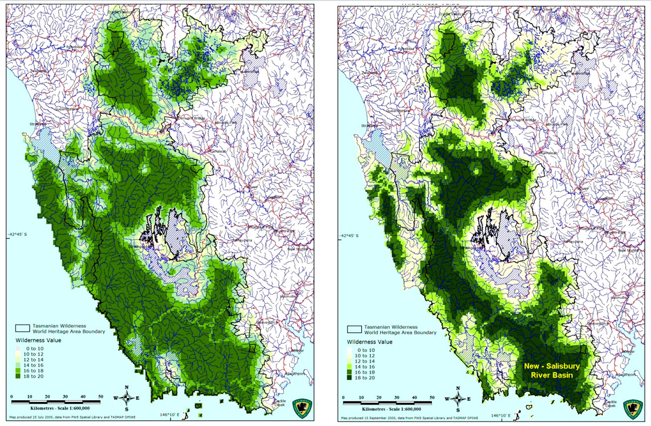
Figure 1: The extent of wilderness in south-western Tasmania (Hawes, 2005). This mapping of wilderness quality is based on grading the biophysical naturalness, apparent naturalness, distance - remoteness and time - remoteness of locations according to (LHS) the established National Wilderness Inventory (NWI) methodology (Lesslie et al., 1988) and a revised methodology used by the Tasmanian Parks & Wildlife Service (RHS). The revised methodology (RHS) achieves a more rigorous delineation of core wilderness areas, and it is noteworthy that this highlights the New-Salisbury River basin as one of the largest core wilderness areas in Tasmania. Note also that a number of smaller core wilderness areas can be similarly defined further northwards in the Tarkine region of north-west Tasmania.
History of Wilderness Karst Exploration in Tasmania
The earliest human discoveries of karst caves in the Tasmanian wilderness were made by Tasmanian Aborigines during the Late Pleistocene, and indeed the caves of south-western Tasmania appear to have been widely used by the Tasmanian Aboriginal people during the last glacial climatic phase when the caves would have provided shelter in a harsh environment, and the surrounding terrain would have been mainly grassland rather than the forest and difficult scrubs which hide many of the caves today. However much of this earlier cave use seems to have declined during the Holocene as new forests and scrub spread through some of the karstic valleys of the southwest. Together with the coming of Europeans and the subsequent displacement of the Aborigines, the previous knowledge of these caves was lost. It has only been with the re-discovery of many of these caves and studies of their archaeological record over the last forty years or so that the widespread extent of former human cave use in the southwest of Tasmania has become apparent (e.g., Jones et al., 1988).
Early European Karst Discoveries in the Wilderness
The karstic limestones of the lower Gordon River area were discovered in the early days of European settlement, and indeed were exploited for lime during the 1830s at the Sarah Island penal settlement in Macquarie Harbour, however there was little systematic exploration of their caves until the 1970s (see further below). Although caves were being explored in some settled areas of Tasmania such as Mole Creek as early as 1829 (Scott, 1962; Clarke, 1999), the karsts of the western and south-western Tasmanian wilderness were only sporadically explored or noted prior to the mid-Twentieth Century.
One of the earliest of the notable discoveries of karst in the Tasmanian wilderness prior to the twentieth century occurred as a result of a remarkable expedition across western Tasmania which was undertaken by the noted (and tragic) arctic explorer Sir John Franklin and his wife Lady Jane Franklin during 1842, while Sir John was serving as Governor of Tasmania prior to his fatal attempt to find a North-West Passage through the Arctic Sea in 1845 - 47. The expedition was one of the first explorations of the region subsequent to the closing of the Sarah Island penitentiary in Macquarie Harbour, and was considered remarkable at the time not only because it was led by a serving governor, but even more so because his wife accompanied him at a time when conventional prejudices held that women were of too delicate a disposition for such exertions (Burns, 1842; Binks, 1980). Lady Jane was the first European woman to travel overland from Hobart to Macquarie Harbour, albeit in deference to the prejudices of the time, she was famously carried part of the way on a palanquin borne by four convict porters! The expedition followed a track expressly cut by an advance party led by Surveyor John Calder, through country which even today remains one of the most remote parts of Tasmania’s wilderness (see Figures 1 and 5). On Christmas Eve 1840, the track-cutting party camped under a large overhanging rock on the plains at the eastern side of the Deception Range south of Frenchmans Cap. That evening they watched a fierce lightning storm from their ‘rocky fortress’, in consequence of which they named the place Christmas Rock, and the surrounds Lightning Plains.
Although briefly recorded in Burns’ (1842) account of the expedition, Christmas Rock has remained rarely visited and little known up to the present (but see Luckman, 1979). Consequently, when the writer and several companions unexpectedly stumbled across the Rock during a wilderness bushwalk in the 1980s, we were excited by our apparent discovery of a large dolomite karst tower or hum (residual karst hill) riddled with caves, arches, a subterranean stream and several spectacular deep grikes (see Figures 2 and 3). Although our later researches revealed the prior discovery of the Rock in 1840, the thrill of discovery was as real to us as if we really had been the first to stumble across this feature.
There is little doubt that as numerous explorers fanned out across western Tasmania during the 1800s in search of minerals, timber and farming prospects (Binks, 1980), caves and other karst features would have been found, but doubtless many went unrecorded and were forgotten. An example of one such early discovery that was nearly forgotten was the discovery of Judd’s Cavern (also known as Wargata Mina) on a tributary of the South Cracroft River in 1881 by Henry Judd and two companions. The cave was briefly mentioned in a book recounting Judd’s explorations and philosophical ramblings (Judd, 1896), which was read by a caver around 1970 and subsequently led to a party of bushwalkers re-locating the cave during Easter 1971 (Cane, 1976). Subsequent exploration has shown this remarkable cave to have over three kilometres of large passages containing alluvial fills dated to over 230 Ka BP (Goede & Harmon, 1983), as well as Aboriginal hand stencils indicative of prior Aboriginal use of the cave (Jones et al., 1988).
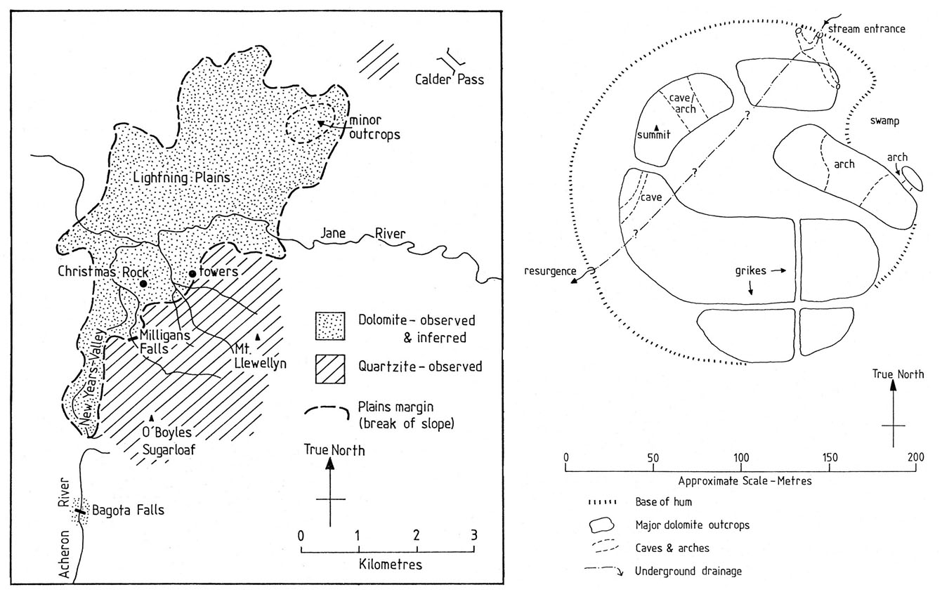
Figure 2: Locality map and sketch plan of Christmas Rock. Reproduced from Sharples (2000).
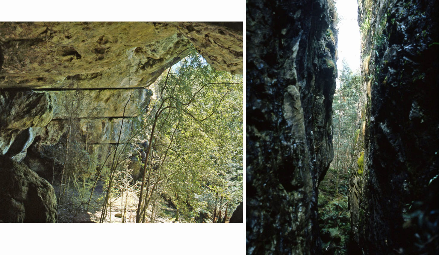
Figure 3: Karst features at Christmas Rock. LHS: Large arch/overhang; RHS: One of several deep grikes running through Christmas Rock. Photos by C. Sharples.
Twentieth Century Karst Exploration in the Tasmanian Wilderness
Although bushmen continued to explore the Tasmanian wilderness during the early decades of the Twentieth Century and no doubt noted some caves in the course of their explorations1, by the middle of the Twentieth Century recreational bushwalkers were beginning to explore the wilderness more frequently. Precipitous Bluff on the South Coast was a peak often visited by bushwalkers, and caves had been reported below the peak by government geologist F. Blake in 1938 (Middleton & Montgomery, 1973).
1For example, Hawes (1981) noted that the legendary bushman Denny King is reputed to have noted caves and ‘castles’ of dolomite in the Weld valley during a trip in 1929.
Although one early Tasmanian Caverneering Club expedition which had gained access to the adjacent New River Lagoon by floatplane in 1960 – 61 found several substantial caves (Middleton & Montgomery, 1973), one of which was explored for 200 metres and thought likely to go much further, there was no further real exploration of the karst until a political issue lead to more exploration during the 1970s (see below).
During the 1970s the Tasmanian bush pilot Jim England reported the existence of a probable karst depression in the remote upper reaches of the New River (Kiernan, 1995; Vol. 2, p. 94), and this feature was subsequently visited by Attila Vrana and Jeanette Collin during a legendary trip down the New River on tractor tyre inner tubes which is thought to have been the first rafting trip down that river. The two are anecdotally reported to have found a stream sink and cave entrance within the large depression; however exploration was limited by boulder chokes (R. Eberhard, pers. comm.). To the present time, no further exploration of the New River depression is known to the writer.
When the construction of a road to allow damming of Lake Pedder made access to the Mt Anne area quicker during the late 1960s, cavers became interested in a large doline in dolomite on the North-East Ridge of Mt Anne, overlooking the Weld Valley, which had been initially explored by an ASF expedition in 1971. A major push during Easter 1983 resulted in the cave being explored to a Tasmanian depth record of 373 metres (Bunton & Eberhard, 1984). One of the cavers who participated in the exploration of this cave, Rolan Eberhard, had recently returned from a caving expedition to the Muller Range of Papua New Guinea and suggested naming the cave Papuan – style, as ‘Anne-a-Kananda’, which roughly means ‘Anne’s Stone House’ (R. Eberhard, pers. comm.). See Figures 12 and 13.
Further down the Weld Valley, dolomites outcropping on the eastern slopes of Mt Weld were being quietly explored by a group of caving bushwalkers in the middle 1970s, who found a 236m deep cave now known as Arrakis, along with some smaller caves lined with coarse quartz crystals now thought to represent an example of hydrothermal karst (Sharples, 1994; Kiernan, 1995). Kiernan notes that these finds initially went unreported in an effort to minimise the likelihood of environmental impacts resulting from excessive exploration, however the area was subsequently ‘rediscovered’ by cavers around 1985 and documentation followed. There has unfortunately been some subsequent theft of quartz crystals from one of the caves (Middleton, 2005), however access with large quantities of caving gear remains difficult and the known caves appear to be only infrequently visited.
In general mid- to late- Twentieth Century exploration of the karst potential of the Tasmanian wilderness has mostly occurred in a sporadic fashion, driven by a few individuals with an interest in both karst and wilderness. In contrast, the main examples of intensive cave exploration in the Tasmanian wilderness have been political responses to proposed developments that threatened to destroy karst and other wilderness values. In one case, namely the Franklin – Lower Gordon River dam proposal, the resulting cave discoveries played a pivotal role in Tasmania’s political history. Several of these more intensive phases of wilderness karst exploration are described below.
Precipitous Bluff
During 1971 an entrepreneurial Mining Company, Mineral Holdings Pty. Ltd., applied for a prospecting licence for limestone in the New River Lagoon area below Precipitous Bluff on the south coast of Tasmania’s wilderness area (Wessing, 1978). It appears that this was a highly speculative venture based mainly on a 1915 report by the former government geologist Twelvetrees, who obtained assay results indicating high limestone purity from a few limestone samples he had collected at New River Lagoon. In retrospect it is unlikely that these few grab-sample results would have been sufficiently representative as to indicate a large enough resource of similarly high quality as to have justified the development of a limestone quarry and transport infrastructure in a location so remote from existing access. However at the time conservationists were concerned that the plans might have sufficient substance as to threaten the integrity of what was by then regarded by many as a wilderness area of significant value (Greg Middleton, pers. comm.). Although an early objection by conservationists in the Mining Warden’s Court obtained a decision that appeared to favour conservation, the State Premier at the time, Eric Reece, encouraged the miners to take their case to the Supreme Court of Tasmania, where Mr Justice Nettlefold ruled that the conservationists “did not hold any estate or interest in the area” in a legal sense (Wessing, 1978).
A few caves had previously been discovered at Precipitous Bluff during 1960–61 (Middleton & Montgomery, 1973). In a response to the evident difficulty of using legal avenues to prevent mineral exploration that might lead to mining of limestone in the middle of a wilderness area, a number of conservation-oriented cavers led by Kevin Kiernan undertook an expedition to Precipitous Bluff during 1973. Their explicit hope was that if significant cave development could be demonstrated below Precipitous Bluff, then this might bolster the case for conserving the area. Over ten cavers participated, and while some walked into the area, a seaplane was also used to transfer people and equipment to the cavers’ base camp at New River Lagoon (Middleton & Montgomery, 1973). A number of notable caves were explored and mapped during this expedition, although it does not appear that this greatly influenced the eventual demise of the mining proposal which was probably doomed to expire of its own accord in any case. However the controversy which arose highlighted a major inadequacy in the law, namely a failure to acknowledge that objectors may have non-pecuniary interests in an area which are just as important as any financial interest (Wessing, 1978), and an eventual outcome of the case was that the Precipitous Bluff area was ultimately incorporated into the Southwest National Park.
Franklin – Lower Gordon Rivers
Subsequent to the demise of limestone quarrying plans at Precipitous Bluff, a much larger and more real threat loomed for another karst area in the Tasmanian wilderness. The Tasmanian Hydro-Electric Commission’s (HEC) plans to dam the Lower Gordon and Franklin Rivers in western Tasmania for electricity generation during the late 1970s and early 1980s led to one of the biggest and most controversial conservation campaigns that Australia has seen; one which was arguably the crucible in which environmentalism became a mainstream movement in Australia (Lines, 2006), and also a turning point in Tasmania’s own political history.
Again, caving conservationists realised that the already-known existence of limestone caves in the Lower Gordon and Franklin River valleys might hold a key to preventing this enormous intrusion into the integrity of Tasmania’s wilderness from going ahead. Consequently during the late 1970s a number of caving expeditions were undertaken into the river valleys that the HEC planned to flood, involving veterans of the Precipitous Bluff case such as Greg Middleton and Kevin Kiernan. Numerous caves, some quite notable, were discovered and documented. Naqvi (1979) compiled plans and details of many of these.
In this case, karst exploration ultimately proved to be a critical factor in stopping the proposed damming of the Gordon and Franklin Rivers. The political controversy led ultimately to a decision in the High Court of Australia, in which the Tasmanian Government challenged Commonwealth legislation which had been passed to outlaw the dam on the basis of Australia’s obligations under the World Heritage Convention. Although much of the campaign against the plans to dam the rivers had centred around the values of wilderness and of wild rivers, in the end the critical issue which swayed the High Court’s decision to uphold Commonwealth legislation stopping the dam was the importance of Aboriginal cultural heritage which had been identified in one of the newly – discovered caves along the banks of the Franklin River (see Figure 4).
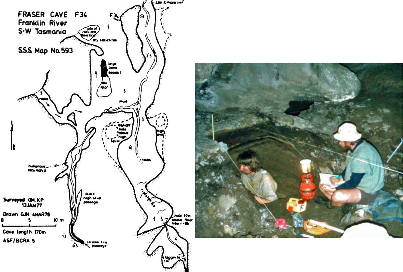
Figure 4: The discovery of Kutikina Cave (initially named Fraser Cave) on the Franklin River, and subsequent discovery of Aboriginal cultural artefacts and evidence within the cave pointing to human occupation of Tasmania during the coldest parts of the last Ice Age, was a turning point in the Franklin River Dam controversy. The potential loss of this cultural heritage was pivotal in the eventual High Court decision to stop dam construction. LHS: Plan of Fraser (Kutikina) Cave , a 170m long cave with a stream passage, dry sections and a large bone deposit, entrance 32m back from Franklin River (reproduced from Naqvi, 1979); RHS: Kevin Kiernan undertaking an excavation in Kutikina Cave with Rhys Jones in March 1981 (Photo by Greg Middleton).
Vanishing Falls
In contrast to the political and to some extent recreational motives that have driven much of the cave exploration that has occurred in Tasmania’s wilderness, there has been little exploration driven by purely scientific motives. This is notable given that there is considerable scientific value in being able to study natural systems such as caves in environments where the effects of human disturbance are negligible. Nonetheless, one expedition that was undertaken for this reason has been recorded by Eberhard et al. (1991), namely a 19922 expedition to Vanishing Falls undertaken by Rolan and Stefan Eberhard along with Vera Wong.
This expedition was motivated by a rare opportunity to examine caves, and in particular cave biology, in an environment as pristine as could be found, albeit the likelihood of discovering new caves in a wilderness setting was also an attraction in its own right (S. Eberhard, pers. comm.). As noted elsewhere in this review, Vanishing Falls (Figure 9) lies in the Salisbury River catchment, which is undoubtedly as close to pristine as any karst catchment in Tasmania. Sponsorship was obtained from Australian Geographic magazine, and the expedition used a helicopter to gain access to this very remote location with the quantities of equipment that were needed. Although this method of access attracted some criticism at the time, it was arguably a very low impact method of access, which given the high cost of helicopter time has not resulted in a flurry of similar expeditions trogging remote caves to death. The expedition discovered and mapped a major cave 2.3 kilometres long associated with the underground course of the Salisbury River below its sinking point at the base of Vanishing Falls (Figure 10), and the expedition yielded scientific fruit with a cave fauna of at least 30 taxa being found having a high degree of troglomorphy. Some of the species found are probably endemic to the Vanishing Falls karst (Eberhard et al., 1991), and the scientific results of the expedition have been the subject of several subsequent published papers (S. Eberhard, pers. comm.). From completely unknown, the geomorphic and faunal values of this still-pristine site are now available to inform conservation management decisions.
There have subsequently been few if any similar expeditions to karsts as remote as Vanishing Falls, and large areas of carbonate rock with obvious karst potential remain mostly unexplored across large parts of Tasmania’s wilderness. Much of the remainder of this review comprises an overview of the potential of Tasmanian wilderness karst.
Geological Background
Although the geological mapping of Tasmania’s wilderness is incomplete – and likely to remain so for some time - the mapping that has been done over the last century or so has demonstrated the existence of large areas of karstic carbonate bedrock in the Tasmanian wilderness. The most karstic stratigraphic units occurring in Tasmania’s wilderness are Ordovician limestones correlated with those forming extensive karst areas such as that at Mole Creek, and thick Late Precambrian age dolomite units including the Weld River Group of the Weld Valley and other correlated units. Some other less extensive carbonates such as the Precambrian magnesite of Tasmania’s north-west are also known to have karst landform development. Figure 5 identifies the main areas of known carbonate bedrock within the Tasmanian Wilderness World Heritage Area.
Some of the more extensive areas of limestone illustrated on Figure 5, such as the Giblin River and Olga Valley limestone areas, are low-relief plains karsts occupying the floors of broad strike valleys where water tables are high and cave development is likely to be restricted to small residual limestone rises. However, western Tasmania is a rugged landscape where prominent bedrock folding structures and glacial erosion have both contributed to creating high mountainous relief in many areas. Many areas of carbonate bedrock underlie slopes with up to 400 metres topographic relief on continuous carbonate bedrock, and in the Weld Valley the topographic relief on parts of the karstic dolomites there reaches over 600 metres. Combined with high average annual rainfalls exceeding 3000mm across much of Western Tasmania, there is considerable potential for the development of deep and extensive subterranean drainage and cave systems in these rocks.
It is notable that the magnesium carbonate rocks dolomite and magnesite generally tend to exhibit less karst development than normal limestones in many parts of the world, yet in western Tasmania both these rock types are extensively karstified. It is likely that this is mainly because of a long period of tectonic and landscape stability since at least mid-Tertiary times has provided enough time for significant karst development to occur in these rocks. Indeed Houshold et al. (1999) considered that some dolomite and magnesite karst landforms in north-west Tasmania had formed under a warmer, more humid mid-Tertiary climate, were subsequently buried by alluvium, and had only been re-exposed by erosion of the sediment mantle in geologically recent times. However, Houshold et al. (1999, p. 16) also identified an additional factor characteristic of western Tasmanian environments that may also contribute to karst dissolution processes in the area, namely that stream and soil waters in western Tasmania are often tea-coloured waters high in dissolved organic material including humic acids.
2Note that although the resulting Helictite paper is dated 1991, it was not actually published until later.
These are derived from the peat soils that mantle much of the western Tasmanian terrain in both moorland and rainforest environments, and were shown by Baker (1986) to markedly increase the rate of dissolution of limestone, dolomite and magnesite. Hence, it is possible that the karst potential of the dolomite rocks of the Tasmanian wilderness is enhanced by one of the other notable characteristics of the region, namely the prevalence of peat soils and derived waters rich in humic acids.
A countervailing factor which inhibits karst development in some areas is the presence of thick slope mantles of glacial and periglacial debris covering carbonate bedrock. However, while these have inhibited karst development in some situations, this is not everywhere the case, and there are many places where karst development has occurred on slopes free of these materials. Indeed it is possible to use slope topography and known upslope geology as a guide to predicting areas most likely to be free of thick mantles of such slope deposits, as they tended to be shed from protruding spurs and funnelled into gullies by the slope mass movement processes which produced these deposits under the colder conditions of past Pleistocene glacial climatic stages.
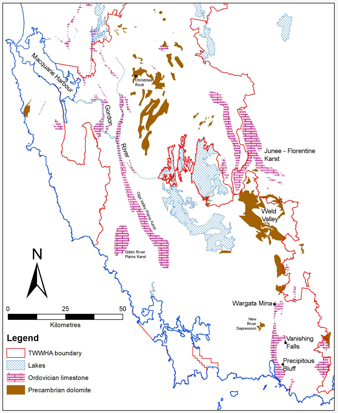
Figure 5: Map of known south-west Tasmania carbonate bedrock with known or potential karst development (based on a digital version of Kiernan, 1995).
Known Unknown Karst (incompletely explored known karst)
It is clear that a great deal of as-yet unexplored karst potential exists in areas of western and south-western Tasmania in locations where carbonate bedrock is known to exist, but either the full extent of the bedrock is unknown and/or the known carbonate bedrock areas have been scarcely examined for evidence of karst.
Indeed, it is of particular note that two of Tasmania’s best known caves, the Newdegate show cave in southern Tasmania’s Hastings dolomite karst, and Exit Cave in the Ordovician limestone karst at Marble Hill, are both located in bodies of carbonate rock whose boundaries have never been properly mapped on the ground and are in fact quite uncertain in parts. As Sharples (2003a) noted, despite the intensive cave exploration that has occurred in and immediately around both these caves, there have been few attempts to explore their carbonate host rocks for more than a few hundred metres beyond the environs of these cave entrances, nor have these regions been of sufficient mineral exploration interest as to justify them being properly mapped by the Tasmanian Geological Survey. In the case of the Hastings karst, during 2003 Ian Houshold and Chris Sharples spent three days floundering around in thick forest in the Hot Springs Creek valley only one kilometre or so upstream of the Newdegate Cave show cave, and were able to not only properly define the extent of the dolomite up that valley for the first time, but in doing so also discovered a number of vertical cave entrances. One of these, now known as ‘Chain of Ponds Cave’ (H5) was subsequently explored during 2004 and, with several hundred metres of spacious passages mapped, it turned out to be one of the longest caves now known in the Hastings Karst.
In the case of Exit Cave, Sharples (1994) speculated that the limestone exposed around the Exit Cave outflow might extend beneath the adjacent D’Entrecasteaux Plains and crop out on the slopes of Mt Leillateah across the valley from Exit Cave (Figure 6). Although this speculation was incorporated into 1:250,000 scale Tasmanian Geological Survey maps – for want of any better geological information in that area – no confirmation of these speculations existed until the author and Rolan Eberhard finally located karstic limestone outcrops below Mt Leillateah during March 2011 (see Figure 7). Despite this, the likely extension of limestone around the lower northern slopes of the plains away from Exit Cave itself is still only confirmed for a distance of a few hundred metres away from the cave entrance itself, although there appears every likelihood that it will occur at the surface on slopes well beyond its presently known extent.
These examples are presented not only for self-aggrandizement, but also to emphasise the potential for new karst discoveries that exists even in parts of Tasmania close to road access, which in turn highlights how extensive the undiscovered karst potential of more remote areas may be. The following sections discuss aspects of the karst potential of Tasmanian wilderness in terms of a number of the characteristics that make it of special interest.
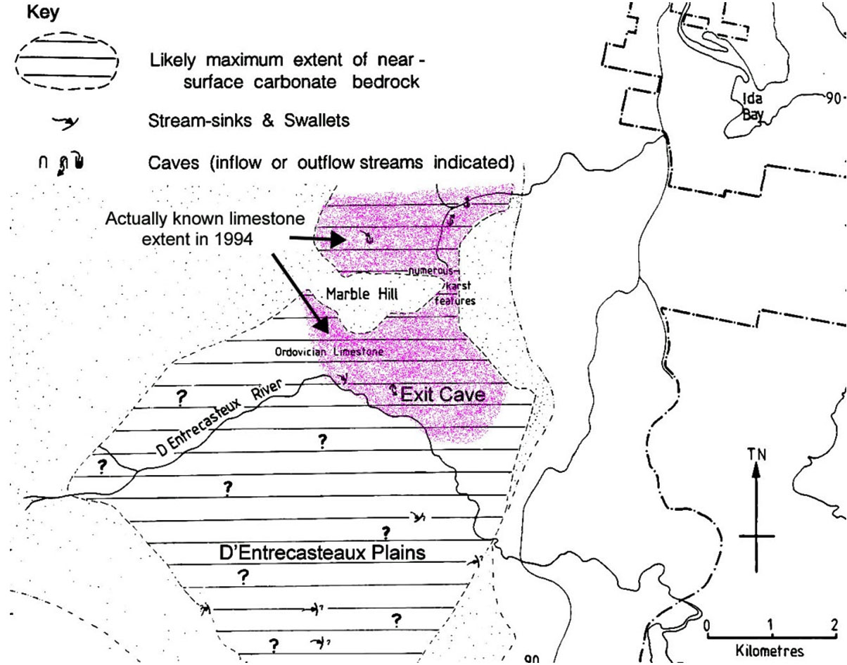
Figure 6: Speculative map of possible limestone extent around the D’Entrecasteaux Plains south of Exit Cave reproduced with annotations from Sharples (1994, p. 57). Although this mapping was later incorporated into Geological Survey 1:250,000 geological mapping (for want of any better information – see Figure 17), at the time it was produced the actual extent of known limestone was only the shaded area around Marble Hill.
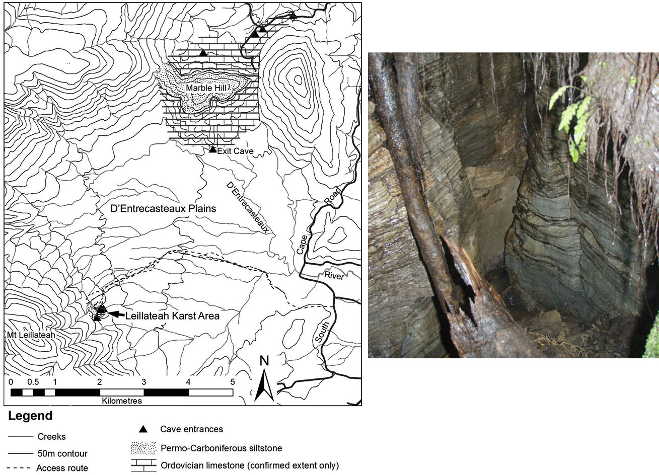
Figure 7: LHS: Location of new karstic limestone area (‘The Leillateah Karst’) discovered by Rolan Eberhard & Chris Sharples on 21st March 2011. RHS: Draughting fissure in a limestone outcrop in the new karst area. This ‘new’ limestone area was readily discovered in preparation for this ACKMA Conference, successfully demonstrating how much undiscovered limestone and karst still remains within day-walk distance of roads in Tasmania, let alone the untapped exploration potential in more remote areas of the Tasmanian wilderness.
Pristine Karst
As was noted above, much of the western Tasmanian wilderness has in fact been modified by past human occupation and especially by anthropogenic firing. However within this anthropogenic landscape there still remain some areas which show less evidence of past human impacts – at least during the last 10,000 years of the Holocene – where the impact of human activities can be expected to be as minimal as could be envisaged anywhere. As it happens, one of the largest such areas is the New River – Salisbury River basin, which also contains significant areas of carbonate bedrock with known karst development, and thus has the potential to be of scientific (and ethical) interest as containing karst systems in as close to a truly pristine state as could be found.
New River – Salisbury River Karsts – Ordovician Limestone and Precambrian Dolomite
The New River –Salisbury River catchment in southern Tasmania covers an area of 309 km2, all of which is contained within the Southwest National Park and the Tasmanian Wilderness World Heritage Area. With the exception of water bodies, some natural alpine grassland on ridge tops, and a small area of button grass and scrub at New River Lagoon, the basin is entirely mantled by old growth forest which has never been logged, roaded, mined, settled, farmed or otherwise significantly disturbed by European settlers, and which also shows no evidence of Aboriginal firing, at least during the Holocene3. As such, the New /Salisbury River catchment is the largest entire source-to-sea river catchment basin in Tasmania which can be said to be free of significant anthropogenic process disturbance on current knowledge. Not surprisingly, current Parks and Wildlife Service wilderness mapping identifies the basin as the largest contiguous core wilderness area in Tasmania (see Figure 1), and thus the closest thing we have to a truly pristine large catchment basin with little or no disturbance of fluvial processes. Given this, the New River – Salisbury River basin has the potential to contain the most pristine karst systems in Tasmania.
Ordovician-age limestone has been mapped and explored at only two locations within this catchment basin, namely at Precipitous Bluff and Vanishing Falls, which were respectively explored for caves during 1973 and 1992 as discussed above. Major caves have been explored at both locations, and indeed Vanishing Falls on the Salisbury River is undoubtedly Tasmania’s most spectacular stream sink, and possibly its largest (Figures 9 and 10). Correlated limestone has also been explored to the north of the New River catchment, in the adjoining Cracroft River valley where the extensive Wargata Mina Cave (Judds Cavern) was rediscovered during the 1970s (Cane, 1976; Goede & Harmon, 1983). However although limestone has only been confirmed at these three limited locations, consideration of the known regional geology and its structure led Dixon & Sharples (1986) to speculate that these three sites probably lie within a continuous belt of limestone extending at least 30 kilometres north to south, most of which lies within the New/Salisbury River basin (Figure 8). If correct – and there seems no reason to expect otherwise – this is an enormous area of limestone with the potential to have as much cave development along much of its length as has already been documented at Precipitous Bluff, Vanishing Falls and Wargata Mina. With a topographic relief of 420 metres on the limestones at Precipitous Bluff (Burrett et al., 1981) decreasing to about 200 metres at its northern end near Wargata Mina, there is also potential for caves of considerable depth to be present.
3The Tasmanian Aboriginal Sites Index (TASI) records rock shelters with possible former Aboriginal occupation below Precipitous Bluff, at New River Lagoon (the New River estuarine lagoon), however no Aboriginal sites are recorded on the TASI database anywhere else in the New River Basin (albeit there has been little systematic searching for such sites in that region). The New River lagoon area awaits serious investigation for evidence of human occupation; however the lack of burnt areas anywhere in New-Salisbury Basin above New River Lagoon suggests little likelihood of significant human disturbance during the Holocene.
Further westwards in the rugged New River Gorge area, a large enclosed depression about 60 metres deep and over a square kilometre in area drains internally to a stream sink which to the writers knowledge has only been visited once on the ground, by Attila Vrana and Jeanette Collin during the1970s (Kiernan, 1995). However Dixon & Sharples (1986) confirmed the presence of dolomite outcrops in the New River Gorge about a kilometre north of this feature (Figure 8).
Given the remote, topographically rugged and densely – forested character of the region in which this feature lies, further exploration of this feature and exploration of the extent of the dolomite would be a particularly challenging undertaking.

Figure 8: Geological map of the New River – Salisbury River basin, showing the known and interpolated extent of karstic Ordovician Gordon Group limestone in the Precipitous Bluff – Vanishing Falls – Judds Cavern (Wargata Mina) area, and the known plus interpreted extent of karstic Precambrian dolomites (a silty dolomite/conglomerate association) in the New River Gorge area. Map reproduced from Dixon & Sharples (1986).
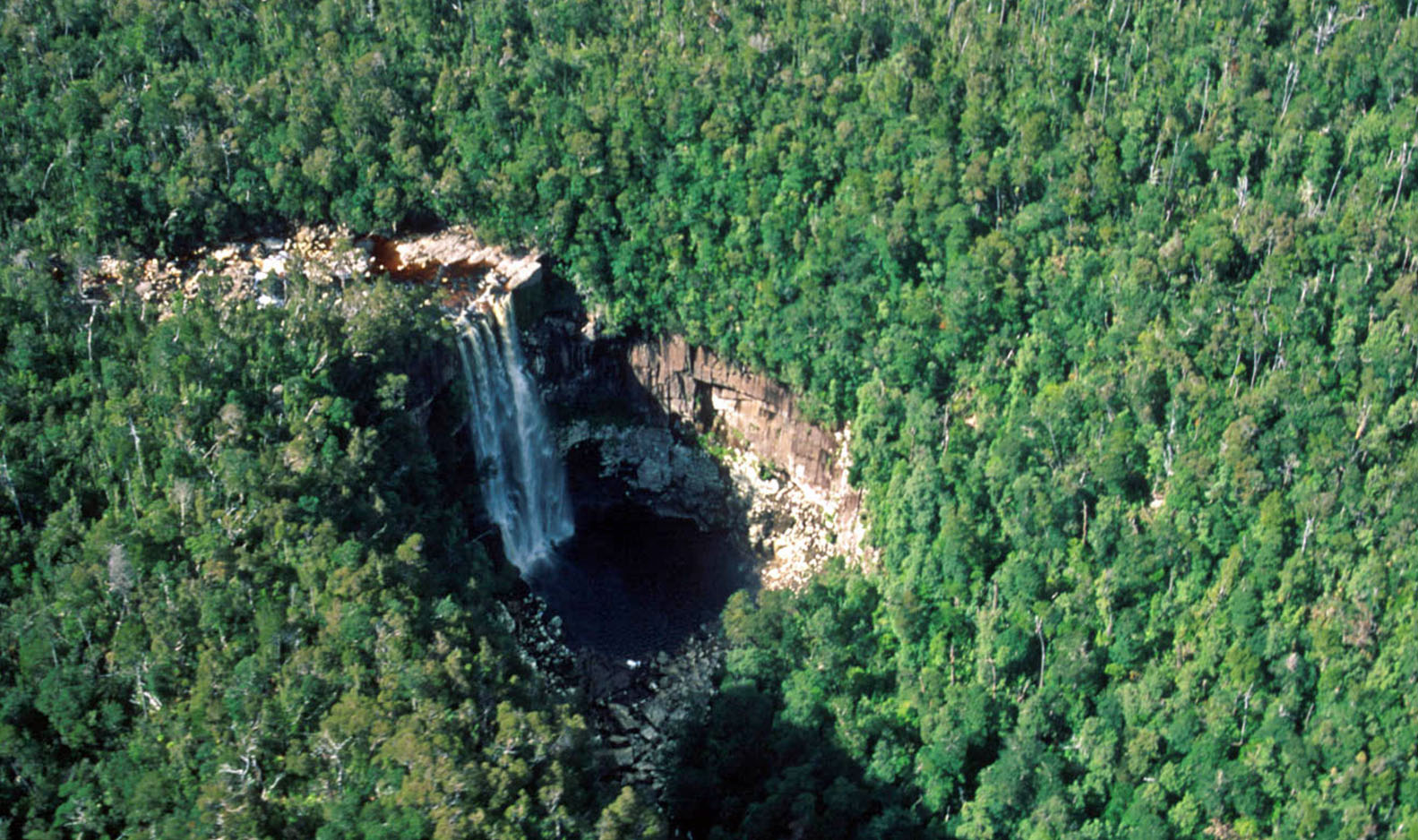
Figure 9: Vanishing Falls on the Salisbury River (the major tributary of the New River) is undoubtedly the most spectacular stream sink in Tasmania, and possibly the largest. The entire river sinks underground at this point, after falling over a lip of dolerite into the limestone basin below, except when flood overflows occur during high rainfall events. Photo by Rolan Eberhard.
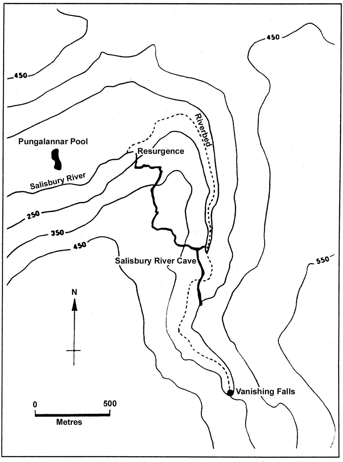
Figure 10: Plan of the Salisbury River Cave, explored at Vanishing Falls by Eberhard et al. (1991). This major cave (>2,300 metres of passage explored) is associated with the underground course of the Salisbury River between its sink at Vanishing Falls and its resurgence several kilometres further down the gorge below the falls.
Extensive Karst
Weld Valley Dolomites
In terms of both topographic relief and horizontal extent of karstic carbonate bedrock, the wild Weld River valley in the eastern part of the Tasmanian Wilderness World Heritage Area stands out as one of Tasmania’s most extensive karstic environments, yet its karst exploration potential remains mostly unexplored except at a few locations.
Nonetheless the extent of dolomite in the Weld River valley is well defined thanks to geological mapping undertaken by Clive Calver of the Tasmanian Geological Survey, shortly prior to the area being protected within the Southwest National Park (Calver, 1989). Although the downstream end of the Weld River valley is State forest subject to logging, virtually all of the known extent of dolomite in the valley is protected by National Park and World Heritage status within an extensive forested catchment almost entirely undisturbed by Twentieth Century roads or other developments (see Figure 11, reproduced from Sharples, 2003). A belt of Precambrian dolomite within this catchment covers an area of over 120 square kilometres, with a vertical topographic relief of over 600 metres from its highest outcrops on the alpine North-East Ridge of Mt Anne to contiguous outcrops in the valley floor below. A 373 metre deep cave, Anne-a-Kananda, was explored on the North-East Ridge from its entrance in a spectacular ridge top doline during the 1980s (Figures 12 and 13), however Kiernan (1990) inferred that water draining into Anne-a-Kananda could drain even further underground to springs in the valley about 600 metres below the cave entrance, possibly passing beneath Lake Timk in hydrologically separated passages (see Figure 14). This area has the highest topographic relief of any karst area in Tasmania, and although several caves a couple of metres deeper than Anne-a-Kananda have subsequently been discovered near Maydena in the Junee Valley to the north, it is entirely possible that the discovery of new leads in Anne–a–Kananda could potentially result in cave depths of up to 600 metres being realised here. This is probably the theoretical limit of depth potential for caves in Tasmania.
Nonetheless topography is very rugged throughout the Weld Valley, and although a number of other caves and other karst features are known there has been very little exploration of this valley’s karst potential away from the North-East Ridge. One particularly notable feature in the valley is the Weld Arch, a spectacular cave through which the entire Weld River flows underground for about a hundred metres (Figure 15). However about a kilometre south of the arch, on a ridge top to the west of the river, topographic mapping shows a complex uvala depression nearly a kilometre long which is indicative of a degree of karst development likely to be widespread in this valley beyond the known features.
In terms of both areal extent and depth potential, the Weld River dolomites arguably offer the most extensive unexplored karst potential in a wilderness setting anywhere in Tasmania.
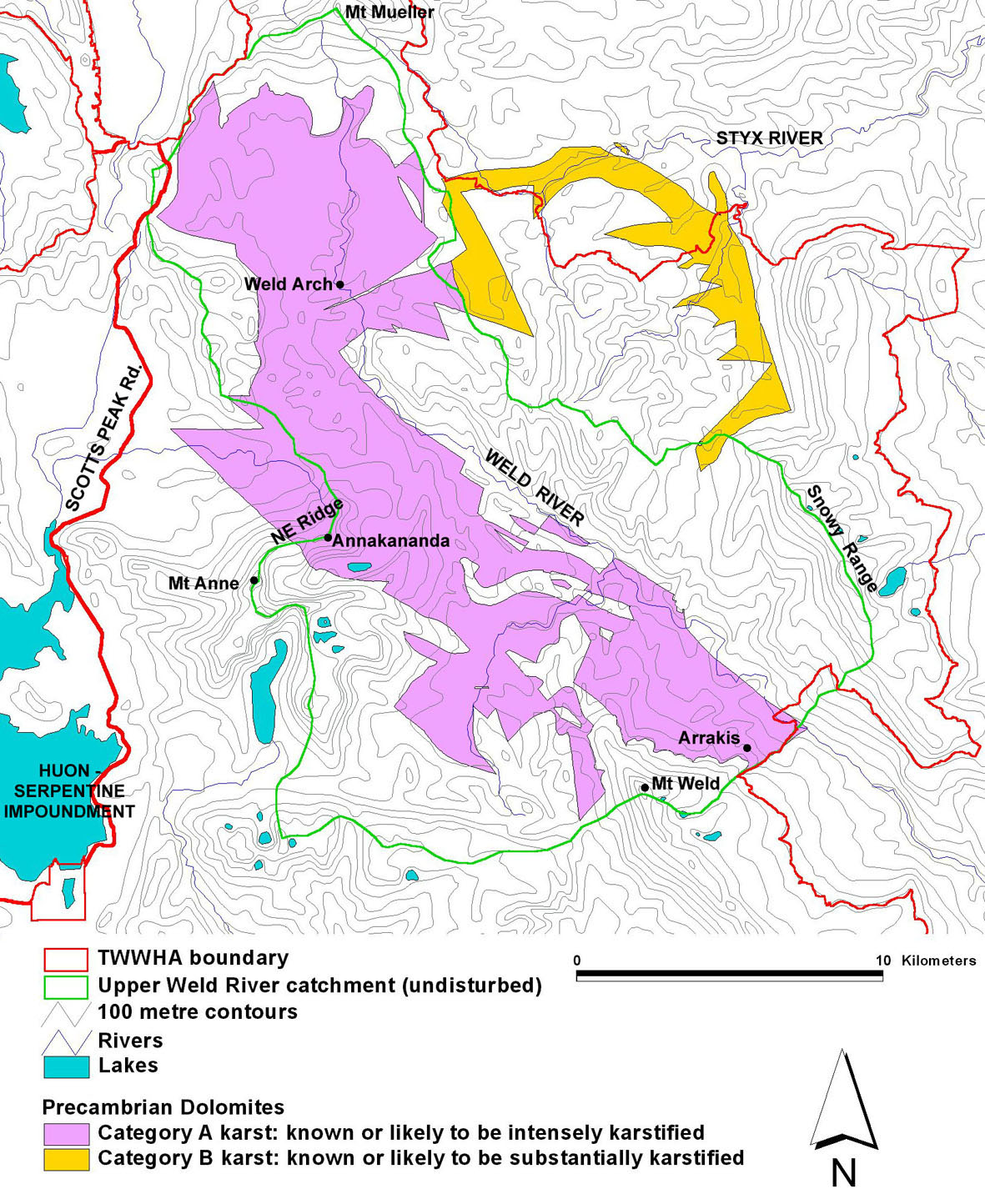
Figure 11: Extent of known karstic dolomites in the Weld valley (figure reproduced from Sharples, 2003), based on field mapping by Calver (1989). The karst categories indicated are based on Kiernan (1995) and are self-explanatory.
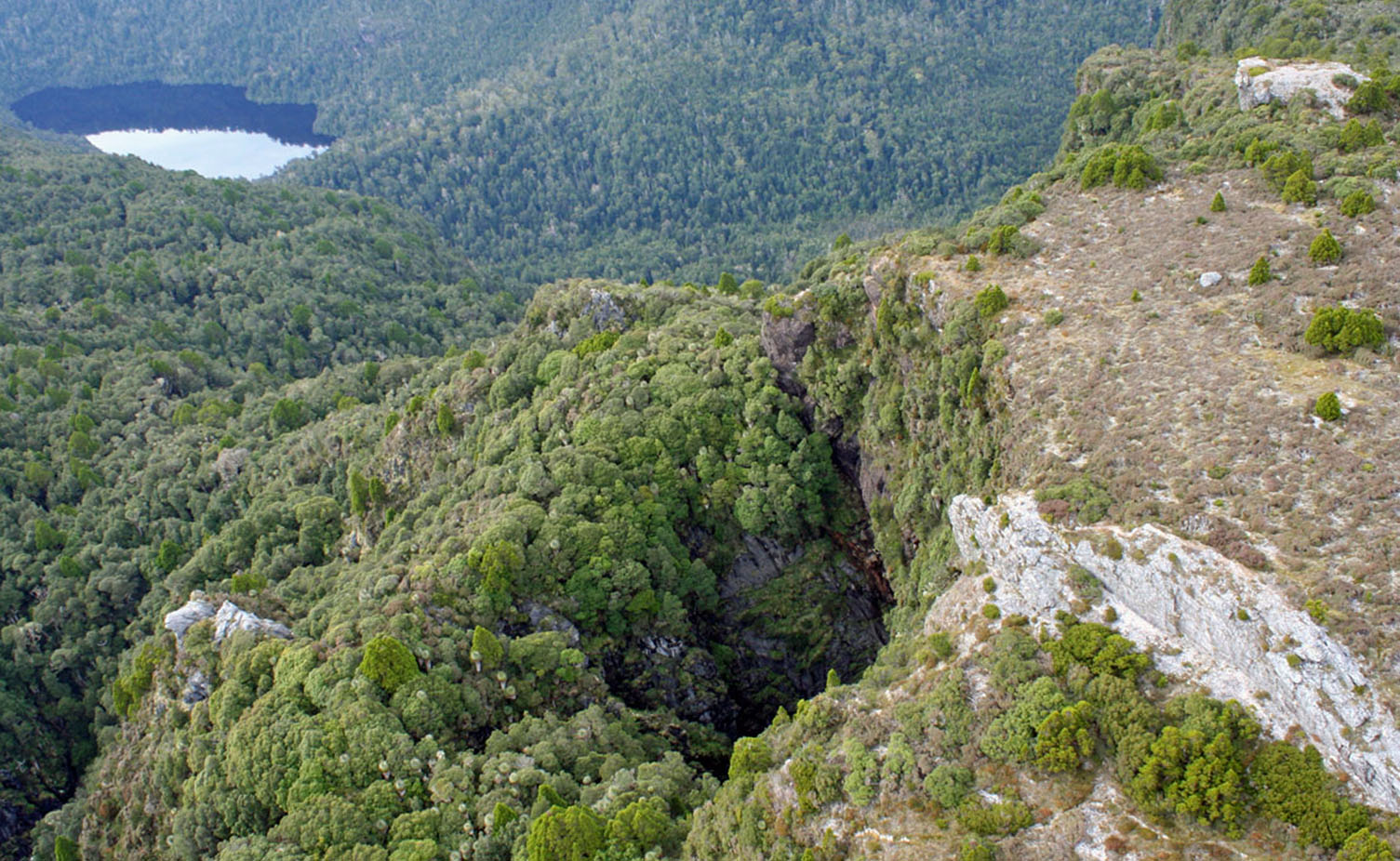
Figure 12: Aerial view showing the spectacular entrance doline of Anne-a-Kananda Cave, high on the North-East Ridge of Mt Anne, with the Weld Valley and Lake Timk visible beyond. Photo by Rolan Eberhard.
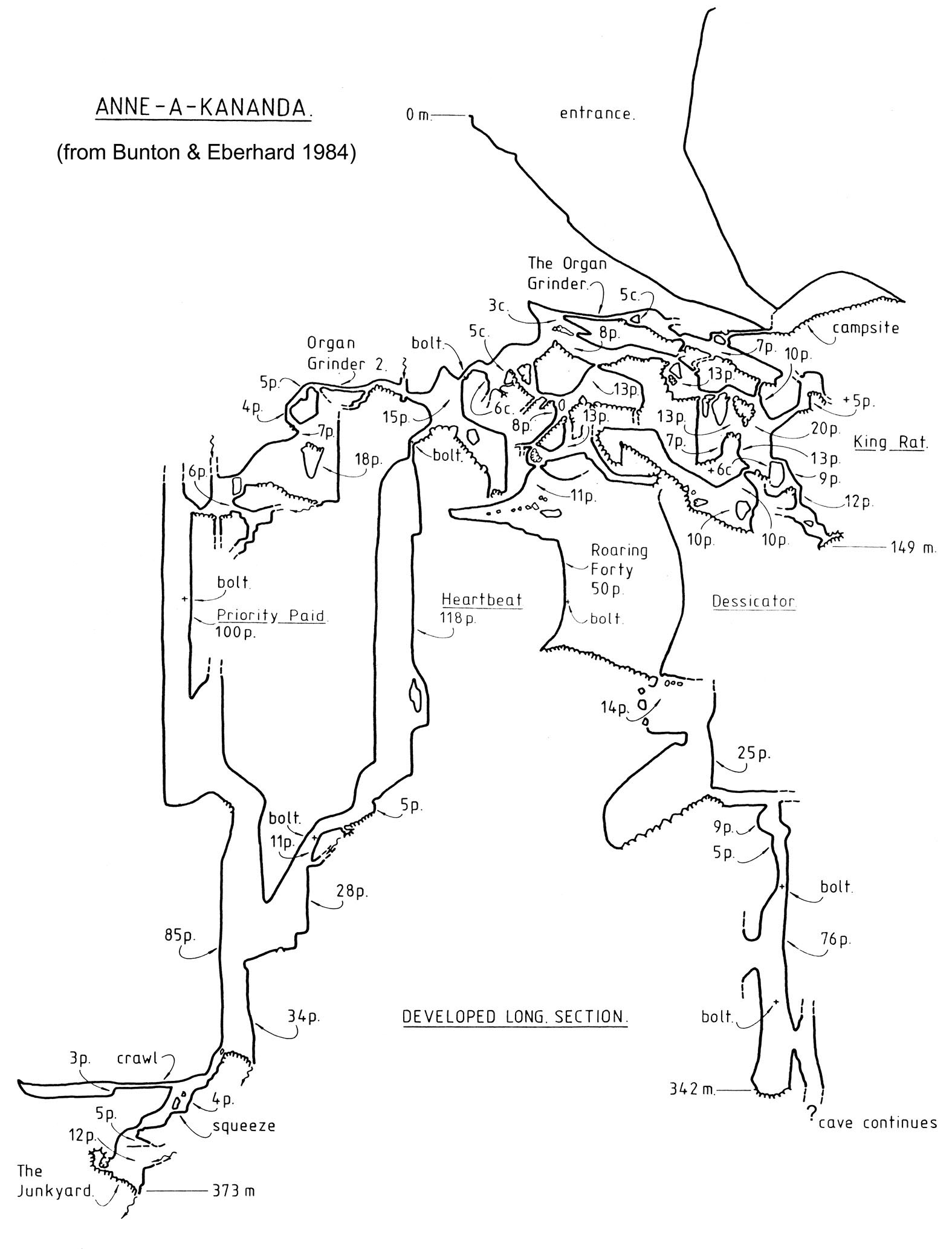
Figure 13: Developed section of the 373 metre deep Anne-a-Kananda Cave (MA9) reproduced from Bunton & Eberhard (1984). Note this section does not show some additional passages discovered subsequently, for example ‘The Dessicator’ and ‘The Rocky Mountain Way’ passages linking ‘Roaring Forty’ to ‘The Junkyard’ (Butt, 2002). At the time it was first explored, Anne-a- Kananda was the deepest known cave in Tasmania, and subsequent “deepest cave” discoveries in the Junee Valley are only 2-3 metres deeper, which is probably within the error margin of the survey techniques used.
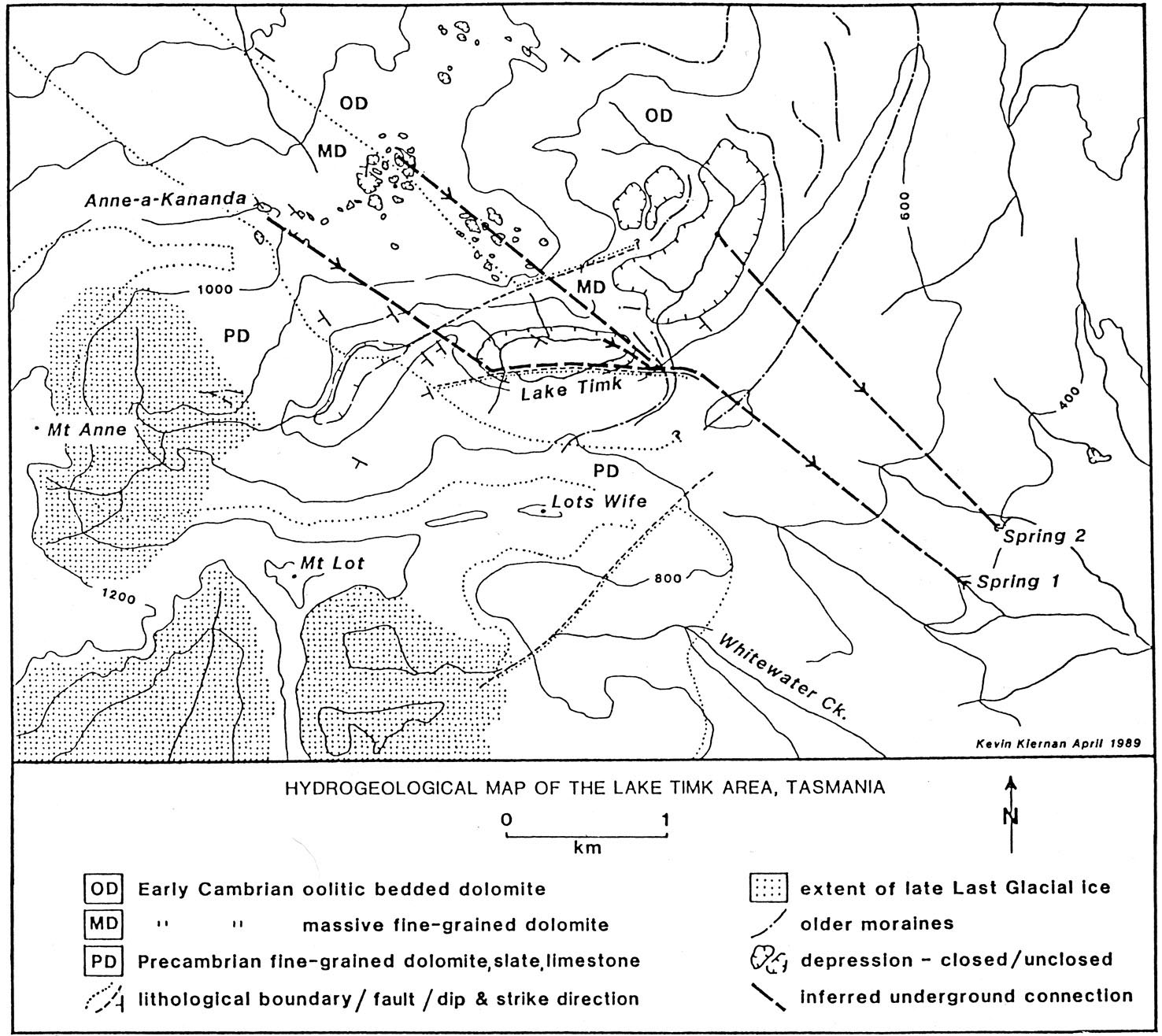
Figure 14: Hydrogeological map of the Anne-a-Kananda – Lake Timk area, showing inferred hydrological connections which suggest subterranean karst drainage of up to 600 metres vertical range (between Anne-a-Kananda and ‘Spring1’). This gives a considerably greater karst drainage depth than the explored 373 m depth of Anne-a-Kananda, suggesting that cave depth potentials of up to 600 metres are conceivable. Figure reproduced from Kiernan (1990).
Figure 15: The Weld River Arch. This spectacular feature – through which the entire Weld River flows underground for about 100 metres – is indicative of the scale of known and potential karst development in the Weld Valley dolomites. Although there were rumours of caves in this region from early bushmen, it was not until the late 1970s that this feature was rediscovered by bushwalkers (Hawes, 1981).
Pindars Peak to Surprise Bay
Steeply-dipping Ordovician-age limestone beds striking roughly north-south outcrop on the shore at Surprise Bay, on the south coast of the Tasmanian Wilderness World Heritage Area. Currently published geological mapping (Tasmanian Geological Survey, 2008) infers a northwards extension of the limestone bedrock up the south-west flanks of Pindars Peak. A significant break of slope at 400 metres on the south-west side of Pindars Peak is strongly suggestive of the upper limit of limestone outcrop. Although to the writer’s knowledge this limestone has never been explored on the ground (by geologists or cavers) inland of the coastal exposures, Kiernan (1995) notes that there have occasionally been vague reports by cavers of karstified limestone on the southern slopes of Pindars Peak; however the basis for these reports is unknown.
Given the likely extent of the limestone, there would probably be potential for caves up to 400 metres deep to exist in this area, perhaps developed along the north-south strike of the limestone beds. More-over, whilst Pindars Peak has been glaciated during the Pleistocene, the glaciers do not seem to have descended the south-west side of the mountain and so would be less likely to have choked any karst development under a mantle of glacial sediments. A further intriguing possibility also exists; given that the limestone at Surprise Bay extends an unknown distance below present sea-level, it is possible that karst development could have occurred to below present sea-level during Pleistocene glacial climatic stages when sea-level stood as much as 130 metres below present levels. This raises the possibility of present day subterranean streams draining to below present sea-level and discharging as submarine springs off the coast near Surprise Bay.
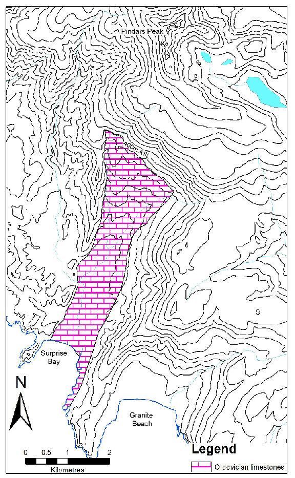
Figure 16: The potential extent of Ordovician limestone between Pindars Peak and Surprise Bay, south coast, Tasmanian Wilderness World Heritage Area. Above sea-level this limestone extends to 400 metres above sea level on a side of Pindars Peak which probably was not glaciated. To the writer’s knowledge this potential deep karst area has never been explored landwards of coastal outcrops at Surprise Bay. Map adapted from Tasmanian Geological Survey (2008).
Unusual Karst
The western Tasmania wilderness karst contains a number of karst features that appear unusual in the Tasmanian context, and whose full extent and nature remain unclear because of their mostly remote locations.
Dolomite Tower Karst
Whereas tower karst is generally confined to warmer & more humid climates than Tasmania’s, it is a feature of some of the little-known dolomite and magnesite karsts of western Tasmania. Christmas Rock at Lightning Plains, discovered during Governor John Franklin’s 1840–42 exploration of western Tasmania (see above), is probably best described as a karst tower, and several smaller towers of dolomite – vertical-sided residual pillars of dolomite up to 15 metres high and 20 x 50 metres across – were observed on the plains within a kilometre or so of Christmas Rock by Sharples (2000). Dixon (1992) has observed similar dolomite karst towers in the remote Algonkian Rivulet valley to the southeast of Lightning Plains, rising to 30m in height and often with caves or overhangs at their base. Houshold et al. (1999) also observed notable karst towers in the magnesite karst of the Arthur River in northwest Tasmania. Most of the karst towers noted to date occur in remote areas of dolomite plains karst and little is known about the processes forming them. However while one explanation for the unusual occurrence of tower karst in Tasmania may be the acidic groundwaters of the buttongrass moorland areas in which many of the observed towers occur, Houshold et al. (1999) concluded that the magnesite karst towers of the Arthur River site were relict landforms that had developed under warmer and more humid conditions during Tertiary times. Hence it may be that the karst towers of the Lightning Plains – Algonkian dolomites are fossil landforms preserved from a time when Tasmania’s climate was warmer and wetter than at present, and so further exploration and study of these features could reveal useful information about Tasmania’s past environments.
Magnesite Karst
Magnesite is a magnesium carbonate rock which is generally much less soluble than calcium carbonate limestone under most conditions, and well-developed karst landforms are globally rare in this rock. However, several narrow bodies of Precambrian – age magnesite outcrop in the Arthur Lineament geological structure within the wild Tarkine region of north-west Tasmania, and a number of small caves and other features had been noted in these deposits by cavers during the 1980s and 1990s (Sharples, 1997). However their karst development was not intensively examined until a proposal to mine the magnesite that arose during the late 1990s led – again! –to a phase of intensive study of these features by Houshold et al. (1999). A number of small caves and notable karst towers were documented, and interestingly it became apparent that several known warm springs in the karst were associated with a large scale subterranean hydrothermal water circulation system which had also been intersected in large cavities drilled into by mineral exploration drilling within the magnesite. It was concluded by Houshold et al. (1999) that many of the magnesite karst landforms evident on the surface were ‘fossil’ karst landforms which had formed under a warmer and more humid climate during the Tertiary Period, and were now being re-exposed by erosion of overlying younger sediments; however a present-day subterranean hydrothermal karst hydrology also remains active.
Interestingly, a substantial portion of the Arthur Lineament in-between some of the known magnesite occurrences remains difficult of access and little-known geologically, and on structural grounds it is possible that further as-yet unexplored magnesite bodies could be exposed in this area lying along strike to the south-west of magnesite in the upper Lyons River area.
Crystal Caves – Hydrothermal Karst
Partial silicification is a widespread feature of Precambrian-age dolomites throughout Tasmania, and may occur within dolomite bodies as ‘box work’ veins, amorphous silica masses or, in some places, crystal-lined vughs. It is likely that some of these differing styles of silicification have occurred in response to different geological processes at different times subsequent to deposition of the dolomite sediments. A spectacular example of the crystalline variety occurs in dolomites on the eastern slopes of Mt. Weld, within the South-West National Park, where enterable dolomite caves have walls lined with coarse quartz crystals up to two centimetres diameter and can properly be called ‘crystal caves’ (Sharples, 1994). Interestingly, some large crystal-lined vughs or avens extend upwards from the dolomite into much younger clastic conglomerate beds which overlie the carbonate rock on an erosional unconformity, implying that the formation of these crystal avens was probably associated with upwards movement of hydrothermal waters dissolving carbonate and precipitating silica at some time after the deposition of the overlying Permo-Carboniferous age rocks. One possibility is that the Mt Weld crystal caves developed in the upper parts of a hydrothermal process system associated with the formation of a metallic ore body that has been explored further down the Weld Valley at Glovers Bluff.
Although no other enterable crystal caves have yet been documented in Tasmanian dolomites, similar coarse silica crystals forming vuggy masses outcrop in dolomites elsewhere in the Weld Valley, in the nearby Styx River Valley, and on Mt Picton (Clive Calver, pers. comm.) Coarsely crystalline quartz ‘geodes’ are also reported from the Tim Shea area near Maydena (Tony Culberg, pers. comm.); although the precise source of these is unclear, it is possible they are associated with Precambrian dolomites that occur immediately south of Tim Shea. Whilst enterable hydrothermal karst caves are a rarity in Tasmania, they do seem to exist in at least one part of the dolomites that are widespread in the Tasmanian wilderness, and the possibility that other such features may exist is a tantalising possibility. However given their apparent rarity, a better understanding of why they are so well-developed on Mt Weld in comparison to other known examples of dolomite silicification in Tasmania will probably require a better understanding of their process of formation in order to predict where other occurrences – if any –may possibly occur.
Unknown Unknown Karst (undiscovered karst areas)
Although some ill-informed commentators occasionally claim that parts of the western Tasmanian wilderness are still ‘unexplored’, this is in general misleading since early prospectors, surveyors and timber-getters thoroughly combed the region in search of resources during the first century of European settlement. Nonetheless it is true that the geology of the region does indeed remain incompletely mapped at a regional scale. In part this is because geological survey mapping in Tasmania has largely been driven by mineral exploration industry requirements (Emyr Williams, formerly of the Geological Survey of Tasmania, pers. comm.), and large areas of (in particular) southwest Tasmania were not thought to have high mineral prospectivity after the early phase of exploration. For the same reason, once large parts of the region were declared National Parks during the late Twentieth Century there was no longer any perceived justification for geological mapping programs in those regions. As a result, even today it remains possible to correctly regard substantial portions of western Tasmania as being genuinely unexplored and unmapped in a geological sense, and it is evident that there still exist possibilities for discoveries of entirely new, previously undocumented areas of carbonate bedrock. The fact that this potential is real is demonstrated by the fact that a number of previously quite unsuspected limestone bedrock areas have indeed been discovered in recent years.
As recently as 1994, geologists Clive Calver and John Everard identified a new area of Ordovician-age limestone on the south banks of the middle Huon River in undeveloped State forest just outside the boundary of the Southwest National Park (Kiernan, 1995). Subsequent exploration of the area, now known as the Riveaux Karst, by officers of the Forest Practices Authority and Department of Primary Industries, Parks Water & Environment led to the discovery of several notable caves including one extensively decorated with Aboriginal hand stencils, whose precise location has remained a closely guarded secret at the insistence of the Tasmanian Aboriginal community.
Even more recently, circa 2009–2010, survey work by Forestry Tasmania officers in State forest at the edge of the Southwest National Park, on the southeast flanks of Mt Picton, led to the discovery of another previously unsuspected Ordovician limestone area in the Lower Picton River valley (M. Cracknell, pers. comm.). This limestone may be a structural continuation of the Riveaux Karst, although it is separated from it on the surface by the overlying dolerites and clastic sedimentary rocks forming Mt Picton.
Although unknown unknown karst is by definition unknown, it is possible to speculate about areas whose bedrock geology is unknown but which on grounds of regional geological structures may have potential to contain as-yet undiscovered limestone, dolomite or magnesite bedrock. One area that has interested the writer is identified below; no doubt other possibilities also exist elsewhere in western Tasmania.
Upper Picton River Valley
Current 1:250,000 scale geological mapping published by the Tasmanian Geological Survey (2008) depicts the upper (southern) part of the Picton River valley, immediately east of the New River – Salisbury River basin within the Southwest National Park in southern Tasmania, as comprising a suspiciously extensive and uniform region of ‘undifferentiated’ Permian and Triassic-age sedimentary rocks (see Figure 17). However this mapping is based on an early regional air photo interpretation of bedrock geology which has subsequently been shown by field mapping to be substantially incorrect for the more downstream (northerly) parts of the Picton valley. In reality no documented ground-based geological observations are known to the writer for this extensive area of around 200 km2, which is an extensive forested wilderness valley that has rarely been visited by bushwalkers, let alone geologists. This is probably the largest remaining area of Tasmania for which there is simply no credible geological information available, and indeed the writer considers that geological maps should depict this area as a blank, since that would more usefully indicate the status of geological knowledge of the area than the current, probably misleading, depiction (Figure 17).
Nonetheless, it is possible to make some speculations about the geology of this Picton Valley ‘hole’ based on mapped geology and known structures in surrounding regions. In particular, Ordovician limestones are extensively present in surrounding valleys of the New and Salisbury River, Lune River, the Surprise Bay area to the south, and they also outcrop in the floor of the Picton Valley itself further downstream to the north (see Figure 17). The regional geological structure of these limestones, together with the known heights of the basal Permo-Triassic unconformity which truncates the top of the limestone in surrounding regions, all point to a real possibility of as-yet unidentified limestone outcropping in the upper Picton Valley, albeit it may be restricted to the deeper parts of the valley adjacent to the river itself. On this basis one promising area for limestone and karst exploration within this Picton Valley ‘hole’ is the lower valley slopes surrounding the Picton – Roberts River Junction, and other parts of the lower valley slopes downstream from there.
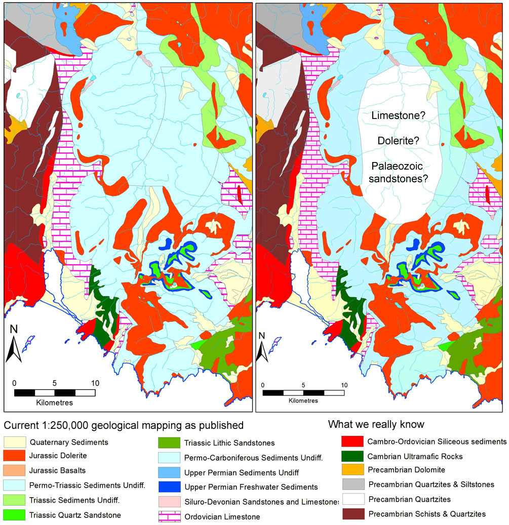
Figure 17: The upper (southern) Picton River valley (within the Tasmanian Wilderness World Heritage Area) is possibly the largest area of Tasmania for which no reliable geological information exists. Although current 1:250,000 scale published geological mapping indicates a (suspiciously large) area of undifferentiated Permo-Triassic sedimentary rocks, this is based on old regional-scale air photo interpretation which has already proven wrong for the downstream (northern) parts of this valley. Given the proximity of known Ordovician limestones and extrapolation of likely geological structures, there is a good chance that significant areas of Ordovician limestone are present in the unmapped Upper Picton ‘hole’. Mapping shown is reproduced from Tasmanian Geological Survey (2008).
The Mystery of Wilderness
There is an argument that I should not have written this review of the karst and caving potential of Tasmania’s wilderness. It is sometimes held that an ineffable mystery is an irreducible part of the core value of wilderness, and that coming to know wild places better in a scientific sense may in some way reduce their value. Similarly it can be argued that exploring, and in particular documenting wild caves is an intrusion of human egos and cold scientific data-gathering into a realm which is better left free of such anthropic values (Kiernan, 1979).
However mystery is a subjective and ephemeral thing; one person’s romantically mysterious wilderness may be another’s regularly visited campsite or well-understood baseline monitoring quadrat. Indeed, it is evident that parts of the western Tasmanian wilderness – including in particular its caves – that are today little-known to most people were for several tens of thousands of years the home and regular stomping ground of generations of Aboriginal people. That such well-tramped places can once again today be regarded as mysterious is a testament to the ultimately subjective and contingent nature of the notion of mystery.
The danger of this notion of mystery is that it can easily slide into quasi-religious mysticism (e.g., see Hawes, 2008) which serves little purpose other than to confuse and bemuse. On the other hand, tangible knowledge and understanding of wild places such as caves is today often a necessity if we are to preserve their natural ecological systems, which after all are the real things that still define them as wilderness. Given the numerous threats to the integrity of present-day wilderness from a variety of human activities - and especially considering the looming threat of anthropogenic climate change which will affect all parts of the Earth including wilderness – it is not useful to regard knowledge as a destructive or detrimental thing. On the contrary, in many cases knowledge is the key to protecting the things we value, as was so successfully demonstrated by the cave exploration and studies that ultimately succeeded in preventing the drowning of wild caves and rivers in the Gordon – Franklin River system during the 1980s.
Just as past Aboriginal inhabitants of the present Tasmanian wilderness must have had an intimate knowledge of those places which allowed them to co-exist with their natural environment, so too it is arguable that in the present day an appropriate degree of knowledge of wild places – including especially scientific knowledge – is not a bad thing. Instead, the right type of knowledge is arguably a tool that we must use to prevent the loss of some of the very aspects of wilderness that we value.
The Future for Wilderness Karst Exploration in Tasmania
It is often said that cavers tend to focus on exploration of known caves and their nearby environs, because access is easy and success is more likely. However as was pointed out to me by an experienced cave explorer following our March 2011 discovery of the ‘new’ Leillateah karst area in southern Tasmania: “it is not necessary to fall back on easy locations like the Junee-Florentine or Marble Hill, where potentially world class caves can be discovered literally hundreds of metres from vehicular access; instead, it is entirely feasible to undertake expeditions at considerable time and expense (not to mention badly scratched arms and knees) bashing your way to remote limestone areas, to find caves 3 or 4 metres long!” (Rolan Eberhard, pers. comm., 23rd March 2011).
More to the point, it seems to this writer as though interest in exploring Tasmanian wilderness karst has waxed and waned alongside a broader waxing and waning of interest in Tasmanian wilderness generally. During the 1970s and 1980s interest in Tasmanian wilderness was at a high level because the future of our wilderness was a high profile political issue, driven in particular by a global awakening of interest in environmental issues, and more locally by plans for imminent hydro-electric development in the Tasmanian wilderness. Interest in bushwalking and wilderness exploration generally was high as a direct result, and for those with an interest in karst, this naturally led to increased interest in exploring karst in the wilderness – in part because of the general interest in wilderness, and in part because it was hoped that major wilderness karst discoveries would provide further reasons to protect the wilderness from development.
Subsequent to the 1980s, with the protection of large swathes of wilderness in National Parks and a World Heritage Area, interest in wilderness exploration seems to this writer to have waned somewhat. Bushwalking is still popular but has become more ‘packaged’ and tourism – focussed. While forestry has remained a high profile environmental issue, with the protection of large swathes of wilderness forest in places such as the Weld Valley this has arguably been less about wilderness forests and more about native forests per se – many of which are not wilderness in any clearly defined sense. This general reduction of interest in wilderness exploration seems to have been paralleled by a reduction of interest in wilderness karst exploration.
However, this review is not a plea for increased exploration of Tasmania’s wilderness karst; rather to some extent it is actually a celebration of the fact that an area with so much evident potential for extensive and impressive cave systems, in relative proximity to intensively explored and accessible areas, can remain so little explored and little known for so long. There seems little doubt that future interest in exploration of Tasmania’s wilderness karst will wax and wane in response to a variety of factors, including but not limited to political and scientific needs. The fact that a phase of moderately intense wilderness karst exploration during the 1970s and after has not led to all-out trogging of the notable caving potential that remains unrealised in Tasmania’s wilderness underlines that we perhaps do not need to be overly cautious or purist in order to protect our wilderness caves; so long as we continue to protect the whole wilderness in which they lie – in tangible, management-oriented ways – the very wildness of these karsts will remain their best long term protection.
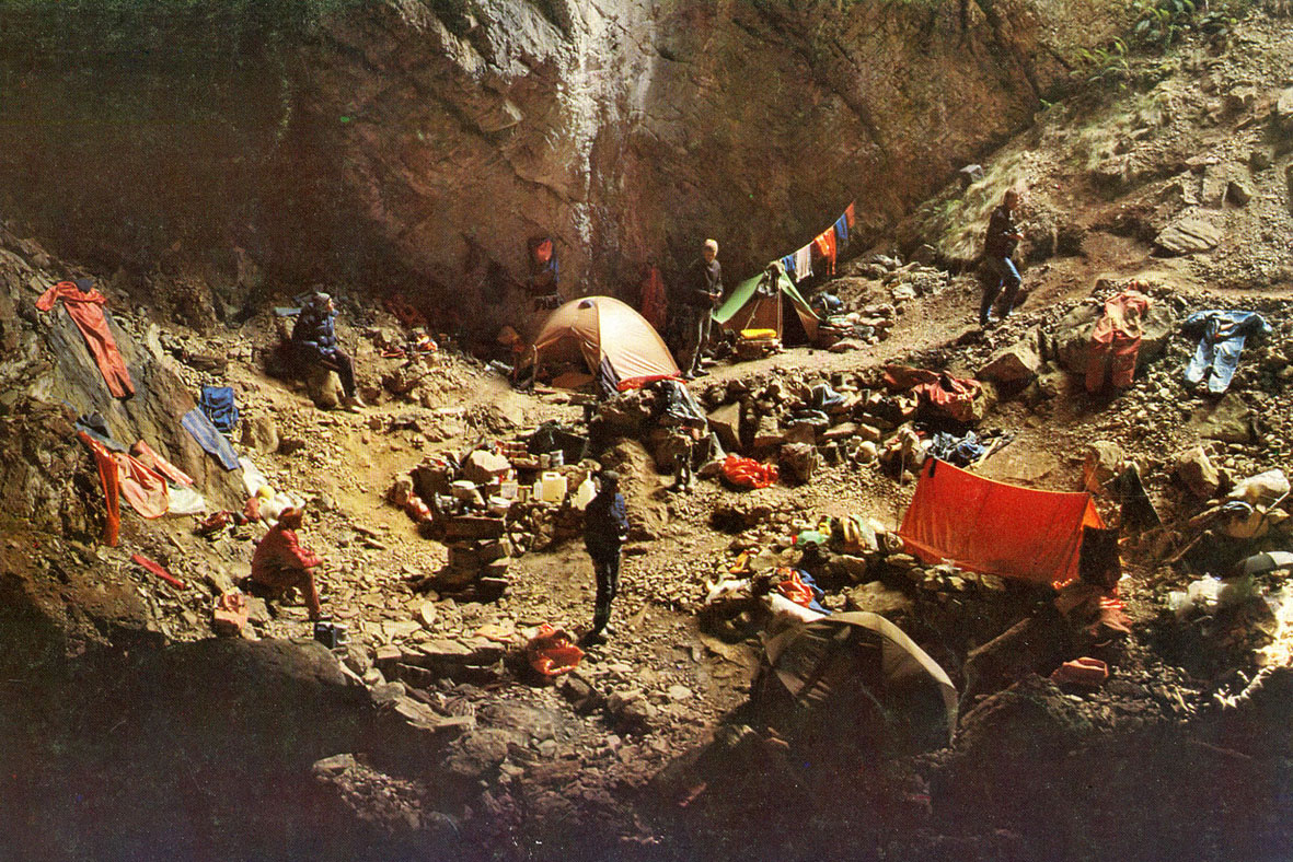
Figure 18: How much impact is acceptable in wilderness karst exploration? This Czech expedition to Anne-a-Kananda in 1987 arguably overdid their impacts on the wilderness environment they were exploring. Whilst exploration of wilderness caves is not in principle detrimental to the value of wilderness, it is important that it be undertaken with particular care to preserve the wild character of such places. Photographer unknown; photo supplied by R. Eberhard
References
Baker, W.E. (1986). Humic substances and their role in the solubilisation and transport of metals. In: D. Carlisle, W.L. Berry, I.R. Kaplan & J.R. Watterson, (eds.), Mineral Exploration: Biological Systems and Organic Matter, Rubey, Vol. 5, Prentice-Hall.
Binks, C.J. (1980). Explorers of Western Tasmania. Mary Fisher Bookshop, Launceston, Tasmania.
Bowman, D.M.J.S. (2008). Is global environmental change the end game for prehistoric vegetation legacies? The parallel cases of fire-maintained vegetation mosaics in southwest Tasmania and central Australia. Australasian Plant Conservation, Vol. 16(3), pp. 6-8, Dec 2007 – Feb 2008.
Bunton, S. and R. Eberhard (1984). Vertical Caves of Tasmania: A Caver’s Guidebook. Adventure Presentations, NSW, 81 pp.
Burns, D. (1842). Narrative of the Overland Journey of Sir John and Lady Franklin and Party from Hobart Town to Macquarie Harbour 1842. Published by George Mackaness in Australian Historical Monographs, Reprinted by Review Publications Pty. Ltd., NSW, 1977.
Burrett, C., J. Laurie and B. Stait. (1981). Gordon Subgroup (Ordovician) carbonates at Precipitous Bluff and Point Cecil, Southern Tasmania, Australia. Papers and Proceedings of the Royal Society of Tasmania, Vol. 115, p. 93-99.
Butt, J. (2002). Three Lightweight Expeditions to Anne-A-Kananda (MA9) at Mt Anne. Good caving and some new surveyed finds. Speleo Spiel, No. 333, p. 3-11, The Newsletter of Southern Tasmanian Caverneers Inc., Nov-Dec 2002.
Calver, C.R. (1989). The Weld River Group: A Major Upper Precambrian Dolomite Sequence in Southern Tasmania. Papers and Proceedings of the Royal Society of Tasmania, Vol. 123, p. 43-53.
Cane, H. (1976). Judds Cavern. The Tasmanian Tramp, Journal of the Hobart Walking Club, No. 22, March 1976, p.40-43.
Clarke, A. (1999). Baldocks Cave: The site locality for the Tasmanian Cave Spider and selected historical references relating to the early discovery of limestone in northern Tasmania and the caves of the Chudleigh (Mole Creek) area. Cave Management in Australasia 13: Proceedings of the Thirteenth Australasian Conference on Cave and Karst Management. ACKMA Inc., 158 pp.
DASETT (1989). Nomination of the Tasmanian Wilderness by the Government of Australia for inclusion in the World Heritage List. Nomination to World Heritage Committee, UNESCO, Paris, prepared by The Commonwealth Department of the Arts, Sport, the Environment, Tourism and Territories, & The Government of the State of Tasmania, September 1989.
Dixon, G. (1992). Notes on the Geology, Geomorphology and Soils of the Algonkian Rivulet – Upper Maxwell River Area, Tasmanian Wilderness World Heritage Area. Papers and Proceedings of the Royal Society of Tasmania, Vol. 126, p. 13-18.
Dixon, G. and C. Sharples (1986). Reconnaissance geological observations on Precambrian and Palaeozoic Rocks of the New and Salisbury Rivers, Southern Tasmania. Papers and Proceedings of the Royal Society of Tasmania, Vol. 120, p. 87-94.
Eberhard, R., S. Eberhard and V. Wong (1991). Karst Geomorphology and Biospeleology at Vanishing Falls, South-West Tasmania. Helictite, Vol. 30(2), p. 25-32.
Goede, A. and R. Harmon (1983). Radiometric dating of Tasmanian speleothems – evidence of cave evolution and climatic change. Journal of the Geological Society of Australia, Vol. 30, p. 89-100
Hawes, M. (1981). Above Me Only Sky: A Portrait of the Tasmanian Wilderness. Drinkwater Publishing, Hobart, 112 pp.
Hawes, M. (2005). Tasmanian Wilderness World Heritage Area Wilderness Mapping Project 2005: Assessments of wilderness values using established (NWI) and revised methodologies. Report to Tasmanian Parks & Wildlife Service, Sept. 2005, 22 pp. plus accompanying maps.
Hawes, M. (2008). The Wildest Country. Wild: Australia’s Wilderness Adventure Magazine, Issue 107, p. 42-45.
Houshold, I., C. Calver and C. Sharples (1999). Magnesite Karst in Northwest Tasmania: Geology, Geomorphology and Hydrology. Unpublished report to Department of State Development, Tasmania, 163 pp.
Jackson, W.D. (1968). Fire, air, water and earth – an elemental ecology of Tasmania. Proceedings of the Ecological Society of Australia, Vol. 3, p. 9-16.
Judd, H. (1896). The Dark Lantern; or, Hidden Side of Nature. The Mercury, Tasmania.
Jones, R., R. Cosgrove, J. Allen, S. Cane, K. Kiernan, S. Webb, T. Loy, D. West and E. Stadler (1988). An archaeological reconnaissance of karst caves within the southern forests region of Tasmania, September 1987. Australian Archaeology, Vol. 26, p. 1-23.
Kiernan, K. (1979). Caves in Wilderness – Should we Record? Southern Caver, Southern Caving Society, Tasmania, Vol. 10 (4), p. 14-15, April 1979.
Kiernan, K. (1990). Bathymetry and origin of Lake Timk, South-West Tasmania. Helictite, Vol. 28(1), p. 18-21.
Kiernan, K. (1995). An Atlas of Tasmanian Karst. Research Report No. 10, Tasmanian Forest Research Council Inc., 2 volumes
Lesslie, R.G., B.G. Mackey and J. Schulmeister (1988). Wilderness Quality in Tasmania. A Report to the Australian Heritage Commission, Canberra.
Lines, W.J. (2006). Patriots: Defending Australia’s Natural Heritage. University of Queensland Press, 406 pp.
Luckman, J. (1979). In the Steps of Lady Franklin. The Tasmanian Tramp, No. 23, p.101-110, Hobart Walking Club, Tasmania.
Middleton, G. (2005). Caves in the Tasmanian Wilderness: World Heritage Area Evaluation 2004. ACKMA Journal, No. 59.
Middleton, G. and N. Montgomery (1973). Southern Caving Society Precipitous Bluff Expedition 1973. Journal of the Sydney Speleological Society, Vol. 17(7).
Naqvi, I. H. (1979). Lower Gordon Region Cave Survey. in: G.E.A. Hale (ed.), Lower Gordon Region: Land Use, Resources and Special Features, Hydro-Electric Commission, Hobart, 113 pp.; Reprinted in Southern Caver, No. 64, Dec. 2008, Southern Tasmanian Caverneers Inc.
Scott, T. (1962). Arthur visits the far North-West. Tasmanian Historical Research Association Papers and Proceedings, Vol. 10, p. 16-23.
Sharples, C. (1994). Landforms and Geological Sites of Geoconservation Significance in the Huon Forest District. Report to Forestry Tasmania, 2 volumes, Feb. 1994.
Sharples, C. (1997). Karst Geomorphology and Values of the Tarkine: Limestone, Dolomite and Magnesite Karst Systems of the Arthur – Pieman Region of Tasmania. Report to Australian Heritage Commission and the Tasmanian Conservation Trust Inc., 176 pp.
Sharples, C. (2000). Notes on karst features at Lightning Plains, Western Tasmania. Speleo Spiel, Newsletter of the Southern Tasmanian Caverneers, No. 317, p. 12-15, Dec. 1999 – Jan. 2000.
Sharples, C. (2003). A Review of the Geoconservation Values of the Tasmanian Wilderness World Heritage Area. Nature Conservation Report 03/06, Nature Conservation Branch, Department of Primary Industries, Water & Environment, Tasmania, 219 pp.
Sharples, C. (2003a) The Hastings Karst – getting it sorted out at last! ACKMA Journal, No. 53, p. 9 – 12.
Tasmanian Geological Survey (2008). Geology of Southeast Tasmania. Geological Atlas 1:250,000 Digital Series, Tasmanian Geological Survey, Mineral Resources Tasmania.
Wessing, P. (1978). The Precipitous Bluff Case. in: H. Gee and J. Fenton (eds.), The South West Book: A Tasmanian Wilderness. Australian Conservation Foundation, p. 263-266.