Canterbury Earthquake Causes Damage To Local Caves
Abstract
Living at Redcliffs, 12km from the centre of Christchurch, I have been associated in many ways with the appreciation of local caves. My book, Delving Deeper: ‘The first 50 years of Caving in New Zealand’ was even launched in one and I have taken many groups to visit them.
Though our history doesn’t compare with that of Australia, Europe or South Africa, von Haast in 1872 excavated Moa Bone Point Cave (very near our home) and it can be noted from the results of this work that caves were very important gauges of geology and climate changes as well as of Maori occupation.
Introduction—Geological History
Geological time covers a tremendous period. It is hard to visualize the building of Canterbury over millions of years of huge pressures caused by earth movements and volcanic activity. Over 60 million years ago we (NZ) separated from Gondwanaland, were immersed under the sea and thrust up to gradually form the Southern Alps. Subsequent climate changes melted glaciers to form the Canterbury plains.
Volcanic activity commenced 12 million years ago and alternate layers of ash and lava were pushed up to form Banks Peninsula and our Port Hills. As a result of these forces we were blessed with an exciting environment of caves, tors, rocky crags and deep harbours. This was great country for rock climbing, mountain biking, walking trails, photography and some lava caving.
September 4th, 2010 at 4.38 am, a 7.1 magnitude earthquake altered forever some of this landscape that had been forming for aeons. The epicentre was located approximately 40 kilometres inland. Some rocks were dislodged, but apart from a severe shaking, there was little damage to the Port Hills. Around 24,000 people, including many local cavers chose to live in the Port Hills environment and smugly felt the rock beneath us was “solid as”.
However, on February 22nd, 2011, the second earthquake was centred under our volcanic Port Hills. At 12.51 pm, within a period of 24 seconds many places, including a number of CCG members’ homes, were reduced to rubble; trampers and residents were killed in rock falls. I was terrified when the red cliffs near our house started noisily crumbling down. Throughout the city area nearly 200 were killed and our city centre of Christchurch, (only 10 kms away) was devastated, especially heritage buildings. Some of our local caves and climbing areas were geographically altered forever, while huge boulders, the size of cars tumbled down.
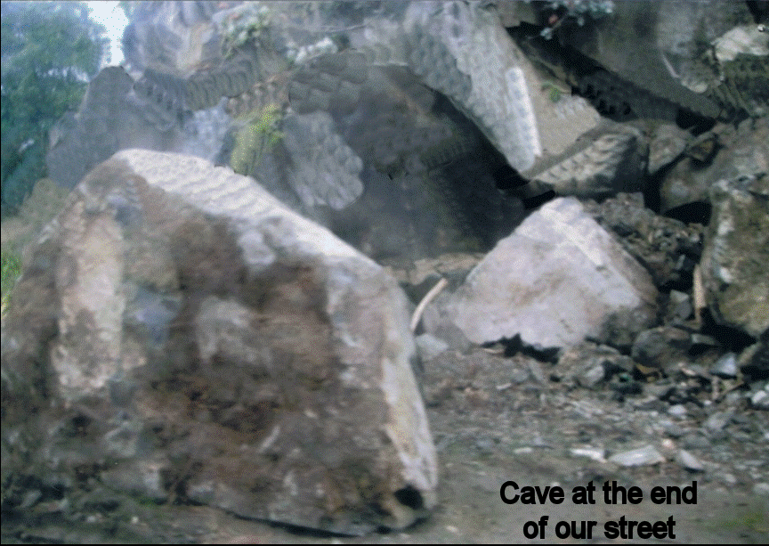
Figure 1: After the Event. Cave at end of our street.
A Place to Live and Love
My love affair with these caves and rocky crags goes back to 1985 when we moved into this area. I was thrilled to have a cave virtually at my back door. I had shown to the Museum various objects of Maori flax art preserved inside caves nearby. So we lobbied that the Council should have two caves and a house purchased by Council and therefore protected. Our request was unsuccessful.
The more research I did the more important the site became. Moa Bone Point Cave was first recorded in 1872 by officers of the survey ship Acheron, and moa bones were found. These were later sent to Richard Owen at the Museum of Science in London to be identified. Julius von Haast also found this a most important archeological site and in 1872 he drew the first cave survey in New Zealand, of this cave. He excavated to a great depth and recorded that it was evident there had not been any geological upheaval in the last thousand years.
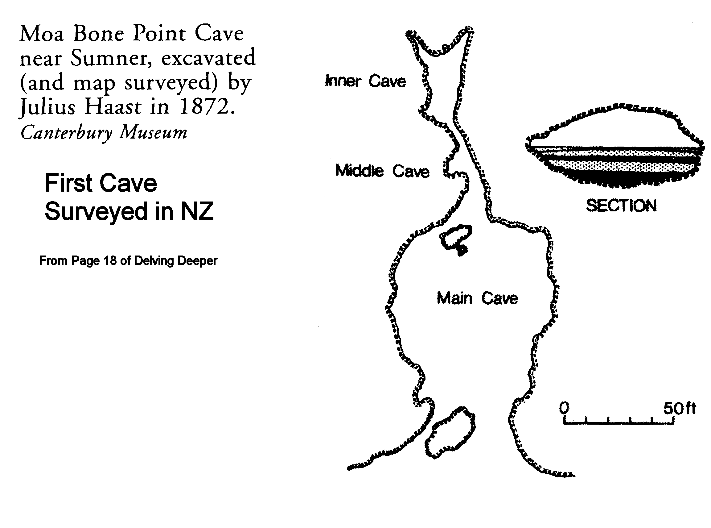
Figure 2: Showing map of Moa Bone Point Cave by Julius von Haast 1849
Local Damage
Five hundred metres away a landslide had exposed Moncks Cave in 1899 during roadwork nearby. Important and rare Maori artifacts (Figure 3) were found and can be seen in Christchurch Museum (when it is declared safe to enter!). Though damaged, it is fortunate that this cave has survived at all. (The supermarket adjacent was being completely demolished owing to liquefaction.)
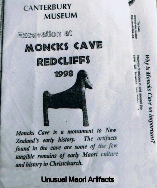
Figure 3:
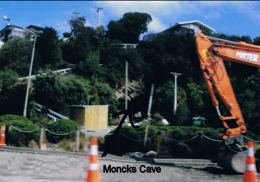
Figure 4: Moncks Cave Site after February 2011
Nearby in Barnet Park a walkway leads to another lava cave. The steps to the cave area are damaged and still cordoned off. My husband Derek (over 80) enjoys this area to keep fit for more serious caving. The historical cave residences at Taylors Mistake, 4 kilometres away, are also barricaded. At the end of our street is a cave which was most suitable for youth groups. Access will be impossible now as enormous rocks have blocked the entrance.
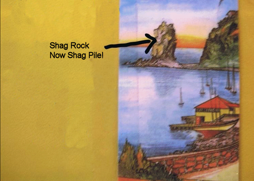
Figure 5: Shag Rock as named, now tumbled to a pile of broken rock
Nearby a landmark volcanic monolith has been reduced from Shag Rock to Shag Pile. On Sumner Beach three kilometres away Cave Rock has always been a popular volcanic site as a cave goes through its centre. The entrance rock has been modified but fortunately little or no damage has occurred to the inside.
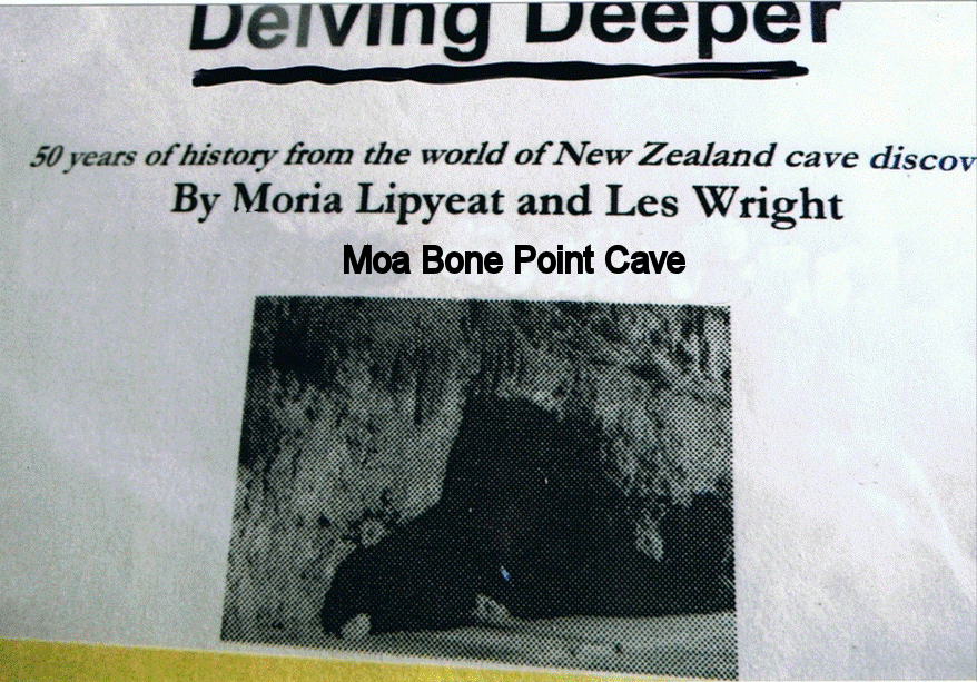
Figure 6:
Delving Deeper
Some of you may own a copy of “Delving Deeper: Fifty Years of Caving in New Zealand” (Figure 6). I compiled this book with Les Wright’s able assistance. The Book Launch was convened in Moa Bone Point Cave. At that event, Richard Holdaway, palaeontologist, spoke on the human history of the area. He referred to the thorough investigation by officers of Christchurch Museum and evidence of at least 600 years of Maori occupation in Moa Bone Point cave. Following Richard’s talk we transferred to another cave nearby (discovered in 1928). The latter had been opened as an “Event Centre” –a very suitable place to have a cave book launch, with candlelight, ample wine and nibbles with soft music. However there would have been no soft music on February 22nd when a gigantic boulder collapsed the entrance.
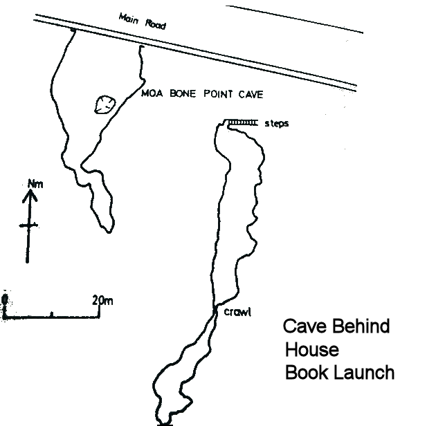
Figure 7: Map of Moa Bone Point Caves
A house built over a cave is teetering over the edge waiting for an aftershock to collapse it on to the road below. This house should not have been built and the area should have been protected.
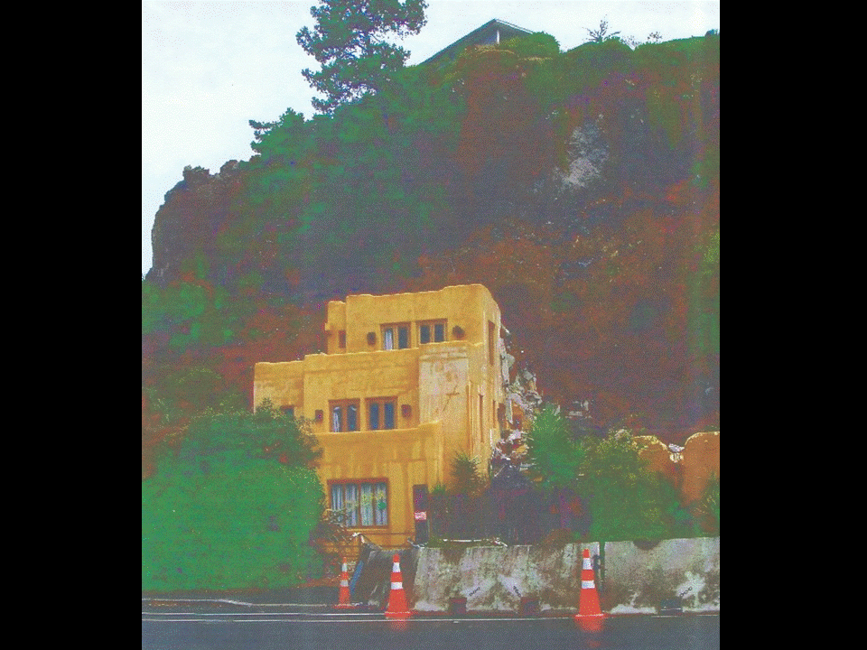
Figure 8: A house built over a cave is tottering over the edge waiting for an aftershock to collapse it on to the road below.
Aftershocks
We have had over 6,000 aftershocks since September! Millions of years of land formation can be shattered in seconds. Forces of nature can be fickle – some parts of Christchurch were very little affected.
Every cloud has a silver lining.
A group of us cavers has purchased land to build a cave base on the West Coast of the South Island. With recycled material from a retirement village (that had to be demolished after the September 2010 earthquake), we have built a cabin on the land as a work base to build a “Cave Lodge”. There is now plenty of recyclable material!
However grants and donations we were hoping for will now all be needed for earthquake rehabilitation.