Planning In A Land Use Mosaic – Innovative Approaches On The Mole Creek Karst
Email: stuart.brownlea@mvc.tas.gov.au
Abstract
The Mole Creek karst system in northern Tasmania is extensive, complex and contains unique values that require consideration in a planning context. Imposed on this natural system is a mosaic of land uses, including a variety of agricultural enterprises, forestry, lifestyle blocks, quarries and reserves. Planning tools to effectively manage karst in such a setting are not well developed in Australia.
Historically, planning in this karst area has taken a broad compliance approach that poses challenges for both developers and Local Government officers seeking to assess potential impacts.
In step with general planning changes under way in Tasmania, Meander Valley Council has initiated an innovative approach to land use planning in a karst context. Science, through risk matrices, provides a robust guide for collaborative assessment between Council and specialists within the Tasmanian Government. Thus improved transparency, consistency, streamlining of process and karst values management are expected.
Background
Development controls in karst areas are critical, yet standardisation and consensus can be elusive. Imposing settlement patterns on karstic terrain implies risk right from the start: risk to life and property from the karst; risk to karst integrity and values from human activity.
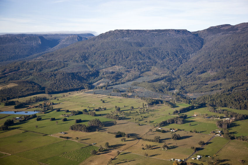
In the Mole Creek area of Tasmania a mosaic of farmland, villages and informal reserves evolved when it was first opened up by European settlers. Timber was initially the resource of choice, whilst trapping and farming played their part in the local economy. Today, a significant portion of the karst and its upper catchment are in formal reserve, whilst farming and forestry dominate a landscape diced up by both the formal and informal reserves. Land on the karst has limited agricultural potential, but has supported dairy and cropping on some of the better soils where supplementary nutrient application and generous, reliable rainfall have made them viable. Most of the private land on the karst is used for raising beef or sheep, fodder crops, private forestry, some limited vegetable and poppy cropping, and a scattering of accommodation and lifestyle blocks with an emphasis on showcasing natural values on their properties and capitalising on the nearby national parks and mountains. There is also a major limestone mine near the Mersey River. Due to changing markets and other factors, there has been a general trend over the last decade away from dairy and toward private forestry.
The geoheritage and biodiversity values of the Mole Creek Karst system are well documented, as are land use interactions (Eberhard, 2007; Eberhard, 2003; Eberhard & Houshold, 2001; Eberhard & Hamilton-Smith, 1997; Kiernan, 1995; Kiernan, 1989), and will not be reviewed here. A geological distribution of karst within the municipality is shown in Figure 1. The karst is also a significant wetland in its own right. It is sufficient to realise that land use planning to assess risk factors must be cognisant of anthropogenic and natural vulnerabilities. It is easy to impact on the equilibrium of karst environments, and changes to it are not forgiving of human intervention. An innovative Local Government approach to development control is the topic of this paper.
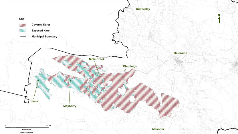
Figure 1: Geology-based Distribution of Karst in the Meander Valley Municipality (Data: Tasmanian Government)
Planning Approaches
Generally karst in Australia is in reserves, or at least in places remote from most development pressures (the Nullarbor Plain may be considered an expansive exception). And so it is with most of Tasmania, with Mole Creek and Gunns Plains being notable exceptions. It is hardly surprising, then, that most municipalities in Tasmania leave karst protection to reserve status, or rely on indirect management that fits neatly with other objectives, such as through water quality and biodiversity schedules in their planning schemes. The Central Coast Council, that has local authority over the Gunns Plains karst, uses zoning criteria as well as general provisions relating to attenuation and land stability. Karst is not specifically addressed (Central Coast Council, 2010). In some jurisdictions elsewhere in Australia a well structured precautionary assessment is advocated (Environmental Protection Authority, 2008), though translating this into consistent, effective Local Government processes is challenging.
The Meander Valley Planning Scheme 1995 (Meander Valley Council, 1995) is the prevailing land use planning instrument covering the Mole Creek area. However, other land management systems also operate concurrently, including Parks & Wildlife Service reserve planning and a forestry industry Code of Practice (that includes guidelines for karst management). Developments are still subject to Land Use Planning assessment, unless a specific exemption is granted. Overarching legislation exists to regulate chemical use, protect identified natural values, and assess environmental impacts of large development proposals.
In the context of this paper change is of most interest, since it is changes to, or intensification of, land use – plus new developments, that trigger Local Government planning. This includes assessing proposed new structures on properties, subdivisions, as well as the implications of new activities. The need for a multidisciplinary approach to karst planning is becoming more evident (Fleury, 2009 p.19).
Although embodying a clear intent to manage karst well, the Meander Valley Planning Scheme 1995 has proved a challenge to implement. Under the Karst Areas schedule (s. 4.10), all developments within the defined karst boundary have to demonstrate general compliance with a series of broadly worded objectives. For example, a proposal is deemed prohibited if “it is likely to induce unacceptable levels of soil erosion”. Assessment issues arise pertaining to who decides on level of acceptability, whether soil erosion is “likely”, what the cost of determining these are, who bears this cost, and what modifications to an application might allay fears all around. In a complex environment it is quite subjective and open to challenge, even with professional advice at hand. The planning boundary for the karst was delineated on specialist advice from the Tasmanian Government in 1995, and included that proportion of requisite geology exhibiting karstic development or exposed rock, and catchment areas immediately associated with these (Figure 2). Implications of developing on covered karst further to the east was less clear and presumably considered less critical, so this was not incorporated.
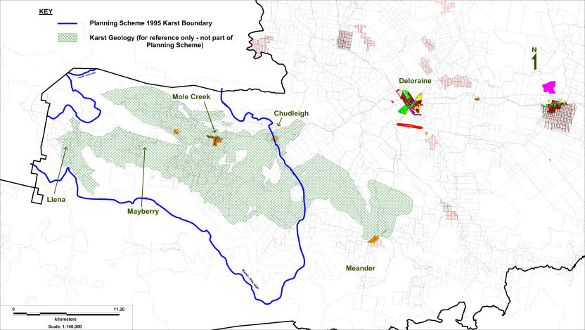
Figure 2: Meander Valley Planning Scheme 1995, with Geology.
Pressures For a New Approach
Quite apart from experience with current planning instruments, other factors provide an impetus for an improved approach. Changes in the fortunes of agricultural markets, tax concessions for the private forestry industry, and demographic trends have led to significant land use changes where outsiders might expect a more conservative situation. Some properties have absentee owners, others have conservation covenants on their land titles, or had portions transferred into reserve. Pressure exists for new tourism opportunities, and for lifestyle blocks to be opened up.
It is also timely to set meaningful protective measures in place, for the integrity of our karst environment, the fragility of which might become more evident as the implications of climate change are better understood. If we impact on the resilience of karst systems through poor planning, then they may be more vulnerable to environmental variation. Various authorities have advocated a cross-tenure approach to karst planning (Williamson D., 2009; Fleury, 2009 pp.20,104; Eberhard, 2003; Eberhard R. and Houshold I., 2001 p.201), and the concept of stewardship on private land is being embraced even more by property owners.
Currently Local Government planning is reaching a crossroads. Overarching, regional planning schemes are being developed to drive consistency and robustness in some areas of planning. Added to this is an intention to upgrade the structure of all local planning schemes to a more modern, performance based style, with common template provisions where appropriate. Thus, change being necessary, it makes sense to go one step further and produce better karst management tools. Meander Valley Council is the only Council in Tasmania working in this area of environmental management.
Some principles for a karst land use planning instrument going forward are:
- It must be spatially based;
- Afford karst protection, based on science and applied for site and landscape outcomes;
- Ensure that an appropriate and proportionate level of assessment can be applied, based on presenting hazard;
- Incorporates triggers for assessment, level of assessment, and quantified acceptable solutions; and
- It must be fair and equitable, recognising the impact of regulation on the community.
Defensible Science
Science makes the planning scheme defensible and transparent. It gives a studied basis for our assessment and solution triggers, and enables supportive spatial mapping. Planning instruments can’t work without boundaries, and the more categorical boundaries, the more tailored responses can be made, however there are trade-offs in terms of complexity.
Tasmania is fortunate in two aspects, namely an enviable (though necessarily incomplete) level of spatial environmental data, and a State Government willing to empower other stakeholders in environmental and land use management. The Meander Valley Council saw an opportunity to capitalise on these advantages. In 2007 a decision was made to produce sensitivity mapping in a small number of categories that would allow for appropriate levels of planning response. Spatially determined vulnerability is a requisite contribution to site hazard assessment for karst protection (Ravbar, 2006 p.171). Wakelin Associates Pty Ltd was contracted to produce a sensitivity map and to populate attendant sensitivity indicator/threat matrices with meaningful, quantified, and scientifically sound response actions (White, 2008).
To inform a renewed planning approach, geoscientists within the Tasmanian Government were given permission to provide Susan White (Wakelin Associates Pty Ltd) with spatial data and advice. A review of existing karst GIS data, and sensitivity analysis, allowed Susan to formulate two mapped sensitivity areas. The data was cleaned to create a High Sensitivity Area, based primarily on exposed karst and known surface features, which incorporated buffers and eliminated unworkable slithers of land. In Figure 3 this is shown in yellow, with the balance of catchment for the whole karst geology then forming the Low Sensitivity Area (in blue).
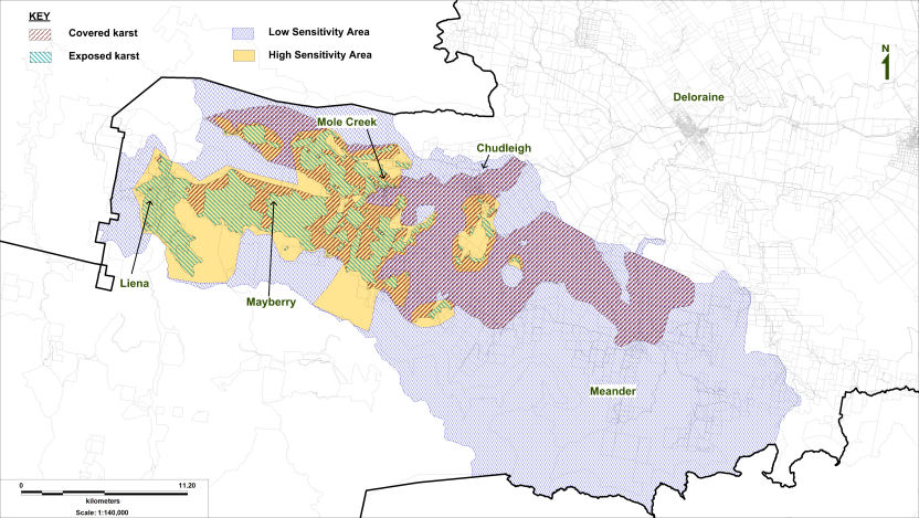
Figure 3: Sensitivity Area Mapping (after White S. (2008) Report to the Planning Department Meander Valley Shire Council, Tasmania: Karst Susceptibility and Planning Matrix).
There are a couple more links required to create a useful planning tool, though. These links are: identifying vulnerable aspects of the karst system, and articulating acceptable solutions to manage risk. What makes a planning tool defensible is its innate scientific credentials, coupled with an ability to explicitly match threats from a development to environmental vulnerabilities either in-situ or in parts of the landscape with demonstrable connectivity.
To this end, a matrix was produced for each Sensitivity Area. In each, sensitivity criteria were mapped against key threatening processes. The matrices were then populated with two types of data:
- A colour coded response level of Prohibited, Discretionary (refer to specialists), or Permitted if Specific Mitigation is Observed.
- Alpha-numeric codes linked to a Key to Acceptable Levels Table that details aims and performance criteria, trigger levels for vulnerability, and acceptable mitigation responses (for “Permitted if Specific Mitigation is Observed” response level).
A sample from the High Sensitivity Matrix is presented below in Table 1.
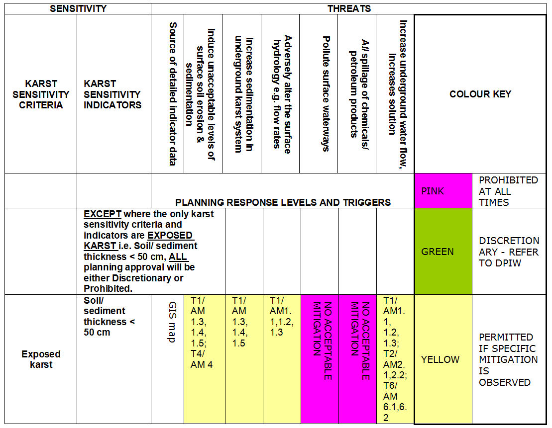
Table 1: Sample of High Sensitivity Matrix White S. (2008) Report to the Planning Department Meander Valley Shire Council, Tasmania: Karst Susceptibility and Planning Matrix. Wakelin Associates Pty Ltd. Clifton Hill, Victoria.
A New Draft Planning Scheme Tool
Internationally, a number of approaches to land use planning on karst have been implemented. Controls of water, be it stormwater or a utilised aquifer, are common responses. More widely they range from measures to protect life, infrastructure and water resources; to those with a natural values conservation focus. The needs from both perspectives should to be reflected in land use planning, but rarely are (Fleury, 2009, pp.19,118,123-131). For the Mole Creek area, the intent is to conserve identified values associated with karst, and through definition of specific vulnerabilities to articulate acceptable solutions. Generally, these requirements align with the need for asset protection, though a technical report may be required in sensitive areas. If acceptable solutions cannot be met, the developer still has recourse to show how conservation objectives can be met through design or siting adjustments, and these are often possible (Milanovic, 2002), though approval in these cases will be at Council’s discretion.
The Key to Acceptable Levels Table (Table 2) is the crucial link between the science and planning. It not only embodies the quantified triggers and responses needed, but is similar in structure and semantics to performance-based planning schedules, allowing for ready translation. Such a translation was undertaken by Council’s Town Planners, in consultation with its N.R.M. Officer. Choices were made as to what level of detail to put into the planning scheme ordinance, and what to retain as an assessment tool for testing development application details against vulnerability mitigation on a case by case basis.
|
AIMS & PERFORMANCE CRITERIA |
TRIGGER LEVELS FOR VUNERABILITY |
ACCEPTABLE MITIGATION |
||||||||||||||||||||||||||||||||||||||||||||||||||||||||||||||||||||||||||||||||||||||||||||||||||||||||||||||||||||||||||||||||||||||||||||||||||||||||||||||||||||||||||||||||||||||||||||||||||||||||||||||||||||||||||||||||||||||||||||||||||||||||||||||||||||||||||||||||||||||||||||||||||||||||||||||||||||||||||||||||||||||||||||||||||||||||||||||||||||||||||||||||||||||||||||||||||||||||||||||||||||||||||||||||||||||||||||||
|
A 1 Minimise erosion to reduce sediment entering all waterways and the Karst System. (Avoid water concentration in any runoff) |
T 1 All removal of soil including for foundations or tracks |
A M 1.1 Excavation and construction must not alter the structure of karst features. A M 1.2 Disperse runoff from access ways, buildings and roads to avoid concentration of water flows entering the groundwater system. A M 1.3 Grassed cut off drains must be used to intercept run off. These drains must run to grassed waterways, settling ponds or reuse dams before water enters streams. A M 1.4 Excavation and construction must not allow movement of sediment and/or soil around site. Any soil/sediment to be removed must not be stored on karst. A M 1.5 Short term holding must be in a way that will not allow dispersal in the event of a sudden rain storm. |
||||||||||||||||||||||||||||||||||||||||||||||||||||||||||||||||||||||||||||||||||||||||||||||||||||||||||||||||||||||||||||||||||||||||||||||||||||||||||||||||||||||||||||||||||||||||||||||||||||||||||||||||||||||||||||||||||||||||||||||||||||||||||||||||||||||||||||||||||||||||||||||||||||||||||||||||||||||||||||||||||||||||||||||||||||||||||||||||||||||||||||||||||||||||||||||||||||||||||||||||||||||||||||||||||||||||||||||
|
A 2 Maintain or restore native vegetation in critical areas for soil conservation, such as steep slopes, karst soils and riparian zones. This should be shown in an environmental management plan for the site. |
T 2 15% slope gradient or 90 slope |
A M 2.1 Do not clear vegetation on sites with slopes over 9 degrees (15%). A M 2.2 Maintain permanent perennial ground cover. |
||||||||||||||||||||||||||||||||||||||||||||||||||||||||||||||||||||||||||||||||||||||||||||||||||||||||||||||||||||||||||||||||||||||||||||||||||||||||||||||||||||||||||||||||||||||||||||||||||||||||||||||||||||||||||||||||||||||||||||||||||||||||||||||||||||||||||||||||||||||||||||||||||||||||||||||||||||||||||||||||||||||||||||||||||||||||||||||||||||||||||||||||||||||||||||||||||||||||||||||||||||||||||||||||||||||||||||||
Table 2: Sample of Key to Acceptable Levels Table White S. (2008) Report to the Planning Department Meander Valley Shire Council, Tasmania: Karst Susceptibility and Planning Matrix. Wakelin Associates Pty Ltd. Clifton Hill, Victoria.
Proposed land use zoning under the Draft Meander Valley Planning Scheme 2007 (Meander Valley Council, 2007) is presented in Figure 4. It should be noted that this Draft Planning Scheme has no legal attributes, as it has neither been endorsed by the Meander Valley Council as a finished product, nor by the Tasmanian Government to bring it into operation. It has, on the other hand, undergone a public exhibition phase and is indicative of what is intended for the Council’s next Planning Scheme.
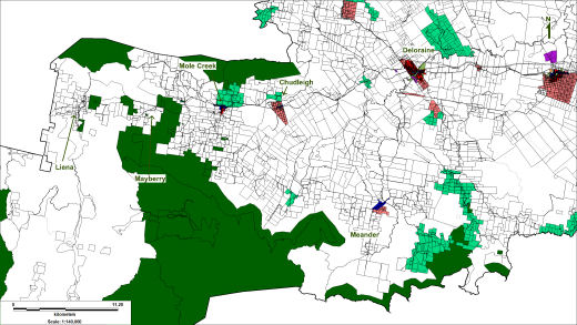
Figure 4: Zoning, Draft Meander Valley Planning Scheme 2007.
Of relevance to this paper is the extent of the dark green Environmental Management zone, expanded to include both public and private reserves. This gives its own restrictions on development, which must meet stringent conservation objectives. A proposed light green Rural Living zone has been added, to meet demand for lifestyle blocks north of Mole Creek and Chudleigh. White represents Rural zoning.
The karst sensitivity areas form a planning overlay, given authority through a Karst Management Schedule and referenced spatial sensitivity zone maps. Thus, development applications must conform to both zone and overlay objectives. Figure 5 displays this interaction. It is the overlay that forms the end point of this paper topic, in a spatial sense. It determines how karst planning ordinance is deployed across the municipality, and what level of assessment is required.
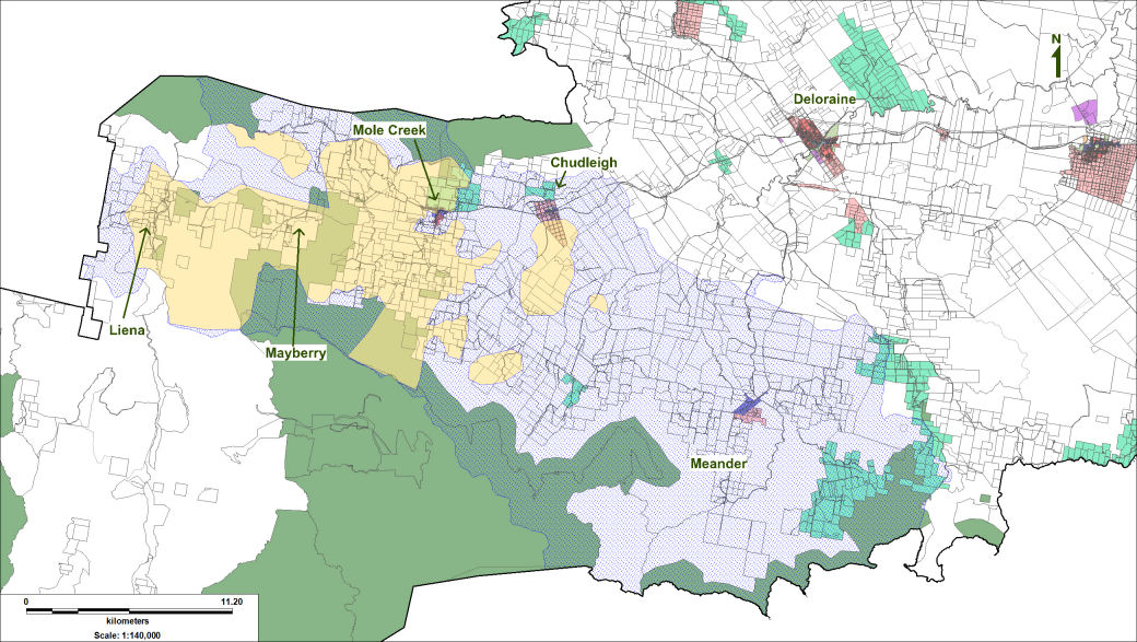
Figure 5: Zoning and Karst Management Overlay, Draft Meander Valley Planning Scheme 2007.
Putting Innovation Into Practice
Because the drafted planning provisions are based on “karst features” that correspond to sensitivity criteria in the matrices, ground truthing is always required to assess actual vulnerability. This is sometimes a challenge given that assessments have to completed within statutory timeframes and technical advice is not always at hand. Where developers can assure requisite mitigation according to the Planning Scheme karst schedule, and the development is within the Low Sensitivity Area, the assessment and approval process appears straightforward. And so it often will be, though there is always the chance of an outlier or unmapped karst feature being present within this area.
A progressive agreement between the Tasmanian Government and Meander Valley Council provides tailored assessments to support planning scheme application. To deal with an outlier anomaly, Council officers have received training to recognise general surficial karst features so that a referral to karst specialists can be made if they are in evidence. Karst specialists also, as a matter of course, provide advice on all development applications in the High Sensitivity Area. To comply with timeframes for assessment, the agreement provides for a streamlined process whereby a single point of entry allows for Tasmanian Government flexibility in allocating staff to reviews to meet deadlines, wherever possible. This results in a process that is more efficient and consistent for everyone involved, including developers.
Planning assessments are triggered by new development or significant changes in land use. These modifications may bring with them some level of hazard, but developers generally recognise limitations of sites and are willing to work toward a responsible development outcome. Indeed, it is often in their interest for structures to be sound and waste correctly disposed of. There is also an increase in general awareness of water and karst values, and the need to take them into account. So, alternative solutions can usually be found.
Conclusion
Limitations of current karst land use planning on karst have been confronted, and a way forward sought. To deal with environmental vulnerability, innovative science-based mapping and matrices designed to articulate into a draft new planning scheme have been developed for the Meander Valley Municipality.
To support the karst planning schedule implementation an assessment process that is targeted, proportionate, defensible and fair has been set up. It embodies credibility and efficiency through a State Government – Local Government partnership.
Acknowledgements
Jo Oliver (Senior Town Planner - Meander Valley Council)
Elizabeth Regent [nee. Grayson] (contracted Town Planner - Pitt & Sherry)
Susan White (Karst Geomorphologist - Wakelin Associates Pty Ltd)
Rolan Eberhard (Karst Officer - Land Conservation Branch, DPIW)
Ian Houshold (Geomorphologist - Land Conservation Branch, DPIW)
Greg Pinkard (Manager - Land Conservation Branch, DPIW) [early in process]
Peter Voller (Manager - Land Conservation Branch, DPIW) [later in process]
John Whittington (General Manager – Resource Management and Conservation, DPIW)
Note: Positions of these contributors are as at 2007-2009, when the Meander Valley Draft Planning Scheme 2007 and supporting processes were being formulated.
References
Central Coast Council (2010) Central Coast Planning Scheme 2005 (Amended 14 October 2010). Ulverstone, Tasmania.
Eberhard R. (2007) Land Classification and Tasmania’s Karst Estate. ACKMA Journal No.66, March 2007, pp.10-14.
Eberhard R. (2003) Discussion Paper: Options for an Integrated Approach to Karst Management at Mole Creek. Natural Heritage Trust Mole Creek Karst Project, D.P.I.W., Hobart.
Eberhard R. and Houshold I. (2001) River Management in Karst Terrains: Issues to be Considered With an Example From Mole Creek, Tasmania. Third Australian Stream Management Conference. Brisbane, Australia, pp.197-203. Edited by Rutherford I., Sheldon, F., Brierley, G. and Kenyon, C.
Eberhard S. and Hamilton-Smith E. (1997) Conservation of Cave Fauna in Australia. Proceedings of ACKMA Conference XII, Waitomo Caves New Zealand.
Environmental Protection Authority (2008) Environmental Guidance for Planning and Development: Guidance Statement No.33. Government of Western Australia.
Fleury S. (2009) Land Use Policy and Practice on Karst Terrains: Living on Limestone. Springer Science + Business Media B.V.
Kiernan K. (1995) An Atlas of Tasmanian Karst. Tasmanian Forest Research Council. Hobart, Tasmania.
Kiernan K. (1989) Karst, Caves and Management at Mole Creek, Tasmania. Department of Parks, Wildlife and Heritage Occasional Paper No.22. Hobart, Tasmania.
Meander Valley Council (2007) Draft Meander Valley Planning Scheme 2007. Westbury, Tasmania.
Meander Valley Council (1995) Meander Valley Planning Scheme 1995. Westbury, Tasmania.
Milanovic P. (2002) The Environmental Impacts of Human Activities and Engineering Constructions in Karst Regions. Episodes Vol.25, No.1.
Ravbar N. (2006) Karst Aquifer Hazard Assessment and Mapping on the Classical Karst. Acta geographica Slovenia 46-2, pp. 169-189.
White S. (2008) Report to the Planning Department Meander Valley Shire Council, Tasmania: Karst Susceptibility and Planning Matrix. Wakelin Associates Pty Ltd. Clifton Hill, Victoria.
Williamson D. (2009) Interim Management Guidelines for the Nullarbor Caves and Selected Karst Features. Proceedings of ACKMA Conference 18, pp.109-119. Margaret River, Western Australia.