CAPE RANGE AND NINGALOO REEF: A SEMI-ARID KARST AND COASTAL AREA UNLIKE ANY OTHER
Director, Geoscene International (A Division of Scenic Spectrums Pty Ltd)
and
Past Chair, IUCN/WCPA Task Force on Caves and Karst
Abstract
The Ningaloo Coast Region of Western Australia is an extraordinary semi-arid karst and coral reef marine environment. The Gondwanan associated geomorphology of Western Australia’s Cape Range, with basic rocks of the coastline of the ancient Tethys Sea, reflects continental drift, subsequent uplifting and evidence of seven of thirteen global geologic themes as identified by Dingwall et al., 2005. Unusual tectonic plate subduction and orogeny processes have created an emergent landscape in which sea level changes over long periods are evident in four wave-cut terraces. Cape Range also has an extensive network of over 700 caves, mesocaverns and anastamosing tubes extending down to an anchialine groundwater zone. The earth’s history, paleoclimate and past life forms are recorded in a rich fossil and sub-fossil accumulation, particularly in relation to the Ningaloo Reef development as a near-shore barrier reef, not a “fringing” reef as thought until recently. An outstandingly rich array of on-going geomorphic, karst, hydrologic and oceanographic processes occur. These are associated with marine, avi-fauna, terrestrial and subterranean speciation, endemism and refugia processes. The Cape Range is a centre of endemism and a relictual taxa refuge for one of the world’s largest and most significant groups of terrestrial and aquatic troglobitic species surviving within a karst system, including the only known example of a Remipede (Lasionectes exleyi) community in the southern hemisphere. The Ningaloo Coast oceanic currents and nutrient cycles; marine flora and fauna speciation, endemism, refugia, breeding/spawning and migratory processes are also outstanding. The outcome is one of the world’s most unique and complex combinations of highly diverse lithological, hydrological and ecological processes. Although the authors are convinced of the area’s global significance, recognition of its values through adequate protected area status and management has been a slow process, with some way to go in the future.
1. Dennis Williamson is Director of Scenic Spectrums Pty Ltd, incorporating Geoscene International. Dennis holds qualifications in Geography (BA) and Landscape Architecture (MLA) and is one of Australia’s leading scenic resource specialists, with wide experience in the areas of natural resource management and tourism development planning. He is a Senior Fellow in the School of Design, University of Melbourne and has contributed nomination evidence to a number of currently listed UNESCO World Heritage Areas, including the Wet Tropics of Queensland, Fraser Island, the Tasmanian Wilderness World Heritage Area and the Wulong Unit of the South China Karst Region. Dennis has recently prepared the Nullarbor Karst Interim Management Guidelines for the Western Australian Department of Environment and Conservation.
2. Professor Elery Hamilton-Smith, AM, has been an Honorary and/or Adjunct Professor at the International Centre of Excellence, University of Wageningen, Netherlands; at the Faculty of Health Sciences, LaTrobe University, Bundoora, Victoria; at the School of Information and Environmental Sciences, Charles Sturt University, Albury, N.S.W. He was also the Chair of Task Force on Caves and Karst, International Union for Conservation of Nature / World Commission on Protected Areas. He has contributed to the nomination assessment process of numerous World Heritage areas globally.
Article
Introduction
The Ningaloo Coast of Western Australia is on UNESCO’s World Heritage Tentative List and will likely be nominated by the Australian Government during 2010. The Ningaloo Coast is the formal name for the nomination area extending southwards along the coast from the Muiron Islands and Northwest Cape. The area includes the Ningaloo Reef and the Cape Range. The Ningaloo Coast property has a total area of approximately 601,000 ha, (263,343 ha of Ningaloo Marine Park-State Waters), 28,616 ha of Muiron Islands Marine Management Area, 258,500 ha of Ningaloo Marine Park–Commonwealth Waters and 50,581 ha of Cape Range National Park (refer to Figure 1). The area predominantly occurs within the area of the Carnarvon – Ningaloo Coast Strategy (WA Dept. of Planning and Infrastructure, 2004 – refer to Figure 2.)
Elery Hamilton-Smith and Dennis Williamson were engaged by Commonwealth Department of Environment, Water, Heritage and the Arts (DEWHA) to provide a comparative assessment of the Ningaloo Coast as background information to the nomination process.
The Assessment Process and Criteria
Two key considerations had considerable influence over the assessment:
- the qualifications of the Ningaloo Coast for inscription to the World Heritage list under the Natural Criteria of UNESCO’s Operational Guidelines (UNESCO, 2008)
- comparison of the natural features and qualities of Ningaloo Coast to those of other globally significant coral reefs and karst systems (World Heritage and other outstanding natural heritage places).
Key World Heritage Natural Criteria included:
- Criterion (vii) - to contain: a. superlative natural phenomenon; or b. areas of natural beauty and aesthetic importance;
- Criterion (ix) - ecological and biological processes;
- Criterion (x) –“in situ” ecological or biological diversity or conservation value.
- Criterion (viii) - to be outstanding examples representing major stages of earth’s history, including:
- the record of life;
- significant on-going geological processes in the development of landforms;
- significant geomorphic features, or;
- physiographic features.
For each criterion the nominated property must represent:
- “outstanding universal value” in representing the “best of the best” natural sites in the world; and
- “integrity” in terms of containing all or most of the significant natural elements and processes, as well as exhibiting site boundaries and buffer zones that will facilitate the protection, management and long-term sustainability of the features, phenomenon and processes that are assessed to be of World Heritage value.
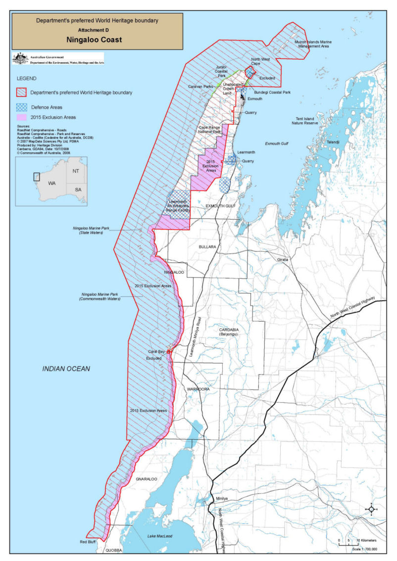
Figure 1 The Ningaloo Coast Nomination Area (Source: DEWHA, 2008)
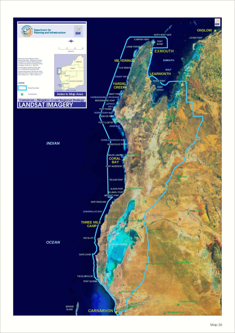
Figure 2 The Carnarvon – Ningaloo Coast Regional Strategy Area (Source: WA Dept. of Planning and Infrastructure, 2004)
International Comparisons
The Ningaloo Coast has been compared against 14 currently inscribed World Heritage Sites exhibiting karst and or coral reef environments and 8 other sites of world significance. These sites are mapped and listed in Figure 3.
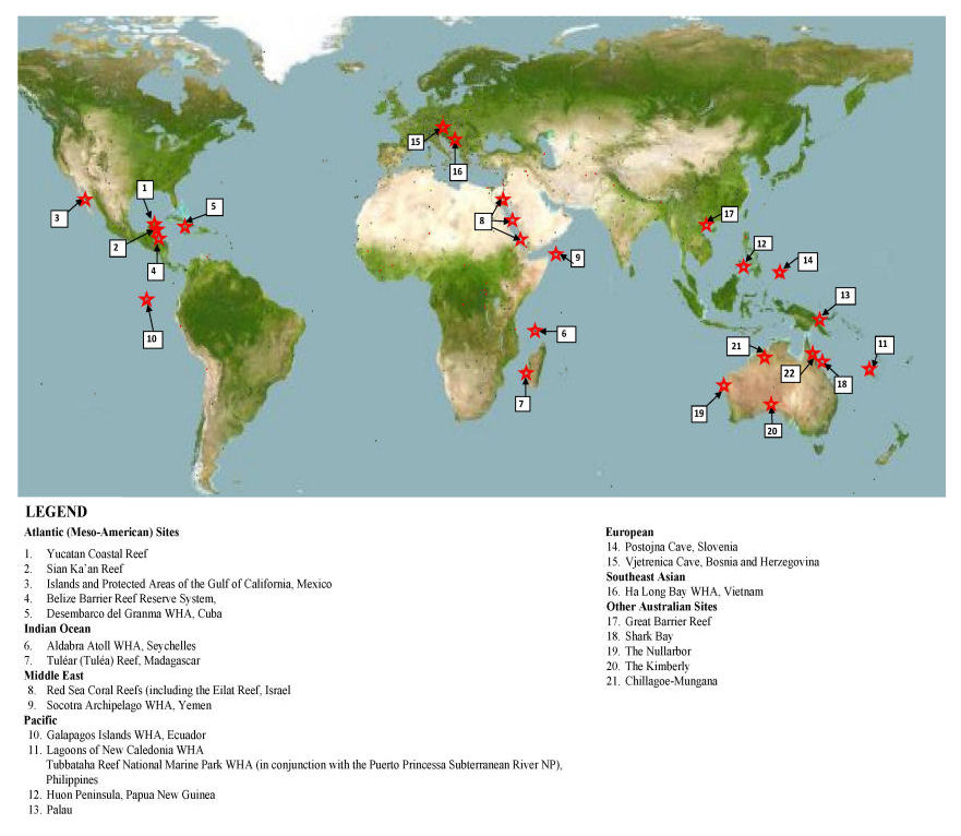
Figure 3 International Sites Used for Comparisons to the Ningaloo Coast (Source: Adapted from UNESCO World Heritage Commission Map of World Heritage Sites, 2008)
Criterion (vii) Assessment and Findings
World Heritage Guideline 1
World Heritage Guideline 1 calls for: “Natural features consisting of physical and biological formations or groups of such formations, which are of outstanding universal value from the aesthetic or scientific point of view”.
Fourteen Ningaloo Coast features were found to meet the above World Heritage guideline. Potential OUV themes noted following each feature or phenomenon as: A = Aesthetic; S = Scientific; E = Emblematic. Some of the key features that meet Guideline 1 include:
- bathymetry;
- coral reefs and lagoons;
- the whale shark and other marine megafauna ;
- Cape Range karst formation with marine terraces and an extensive system of caves and mesocaverns (refer Figure 4);
- Cape Range subterranean fauna (including the rare Remipede Community);
- a hotspot of non-marine endemic molluscs and unique and diverse vegetative species mix from temperate, arid and tropical provinces;
- groundwater and hydrologic system underlying Cape Range and interconnected with Indian Ocean and Exmouth Gulf waters (refer Figure 5).
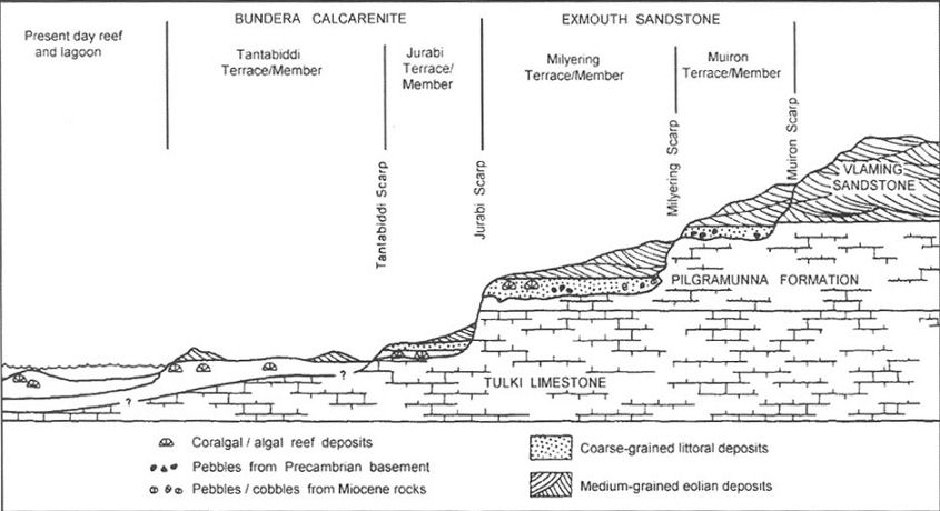
Figure 4. Four Wave Cut Marine Terraces of Cape Range (Source: INQUA, 2006 – after van de Graff et al. 1976)
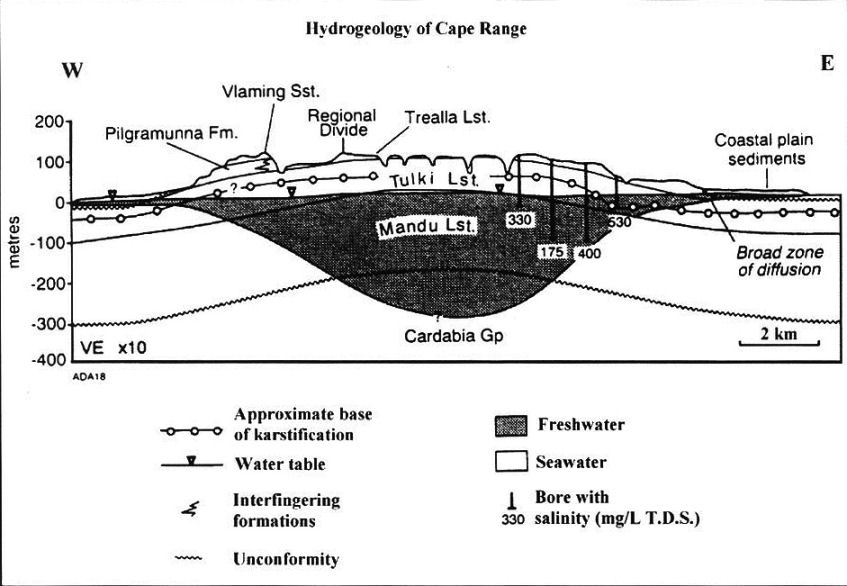
Figure 5 Hydrogeology of Cape Range (Source: INQUA, 2006 – after Allen, 1993.)
World Heritage Guideline 2
World Heritage Guideline 2 calls for: “Geological and physiographical formations and precisely delineated areas which constitute the habitat of threatened species of animals and plants of outstanding universal value from the point of view of science or conservation”.
Under Guideline 2, we would include Declared “Rare, Endangered, Threatened or Vulnerable” or “specially protected” species of animals and plants of the Ningaloo Coast property as noted below (refer to Kendrick and Mau, 2002 – 2002 Biodiversity Audit for WA – Carnarvon Bioregion: Cape Range Subregion - CAR1):
- Whale shark S, A, E;
- Blue, Southern Right, Fin, Sei and Humpback Whales S, A, E;
- Loggerhead, Leatherback, Green, Hawksbill and Flatback Sea Turtles and their nesting areas S, A, E;
- Dugong (special protection) S, A, E;
- 13 species of migratory birds (CAMBA & JAMBA Treaties Protection) including:
- the White-Winged,
- Bridled and Caspian Terns,
- White-Bellied Sea-Eagle,
- the Wedge-Tailed,
- Flesh-Footed Shearwaters,
- the Brown Booby, and
- Wilson’s Storm-Petrel S, A;
- Mangroves:
- red, white and ribbed-orange;
- found in the northern half of the Marine Park;
- largest community occupying 31 ha at Mangrove Bay;
- also found in tidal creek systems such as the mangal at Yardie Creek S, A;
- Approx. 38 species of WA Schedule 1 mammals, birds, reptiles, fish, arachnids, crustaceans, and millipedes S, A;
- Cape Range Remipede Community at Bundera Sinkhole S, A, E;
- Camerons Cave Troglobitic Community S, A;
- Troglobitic and Stygofauna communities on Northwest Cape S, A;
- Ephemeral creekline drainage communities S, A;
- 8 species of Declared Rare and Priority Flora S, A;
(Again, the potential OUV themes include: A = Aesthetic; S = Scientific; and E = Emblematic.)
Cape Range National Park is also of high conservation value floristically, containing many range-end populations of flora at the limit of heir distribution. Cape Range Peninsula lies at the overlap of three biogeographical zones, including species from temperate, arid and tropical provinces.
World Heritage Guideline 3
World Heritage Guideline 3 calls for: “Natural sites or precisely delineated natural areas of outstanding universal value from the point of view of science, conservation or natural beauty”.
Guideline 3 is satisfied by the features and phenomenon noted under Guidelines 1 and 2, including:
- The precisely delineated marine areas of the property include the following geological and physiographical formations constituting the habitat of threatened species of animals and plants of outstanding universal value:
- the West Australian, Leeuwin and Ningaloo Ocean Currents that create the outstanding conditions of water temperature ranges, salinity concentrations and nutrient transport within the property to support the diversity of coral, molluscs and fish, as well as the declared rare, threatened, endangered or specially protected species S;
- complex intertidal and subtidal geomorphic features in ocean waters S;
- the Muiron Islands (continuation of Cape Range) are precisely delineated low, dome-shaped limestone islands. Displayed on the west are limestone cliffs, sandy beaches, intertidal rock platforms and seafloor slopes to continental shelf edge 30 km seaward. Displayed on the east are low dunes and sandy beaches gently sloping seaward with patch reefs and coral bommies, gradually levelling out into soft, muddy substrates. S, A;
- marine habitats and coral structures as delineated in Figs. 3 and 4 of the Management Plan for Ningaloo Marine Park and Muiron Islands Marine Management Area (CALM, 2005) and:
- coral reef communities (intertidal, shallow/limestone and subtidal) S, A, E;
- deep water mixed filter feeding and soft bottom communities S;
- macroalgae (limestone reef) S;
- pelagic water (deeper than 100 m) S;
- shoreline and subtidal reefs (low relief – lagoonal and low relief – seaward) S, A;
- unusual and restricted terrestrial, marine and subterranean habitats including:
- rock shelter areas providing habitat for small colonies of Rock Wallaby;
- the nutrient rich mix of tropical and temperate water currents that attract the whale shark and a diversity of marine life;
- mangal at Mangrove Bay and the aquifer in which blind aquatic fauna live S;
- Cape Range includes a complex system of karst landforms, including:
- closed depressions S;
- surface solution sculptures S;
- sinkholes (e.g., Bundera Sinkhole) S, A, E;
- shallow uvula S;
- caves (including rock shelters, short horizontal caves, larger horizontal caves, vertical caves, caves of the coastal plains, protocaves and mesocaverns) S, A, E;
- Tulki Limestone caps S;
- biokarstic features (tufa accumulations and the Ningaloo Reef) S, A, E;
- hydrogeologic features and systems forming habitat for subterranean fauna:
- Cape Range groundwater mound (freshwater) S;
- karst aquifer system at crest of range (in Mandu Limestone) S;
- internal drainage and cave openings on the crest of the range S;
- drainage line infiltration. S.
World Heritage Guideline 4
World Heritage Guideline 4 calls for: “Cultural and/or natural significance which is so exceptional as to transcend national boundaries and to be of common importance for present and future generations of all humanity. As such, the permanent protection of this heritage is of the highest importance to the international community as a whole”.
Cultural significance is not assessed in this comparative analysis. Features of natural significance that would meet the criteria include:
- Ningaloo coral reef and lagoons (refer Guideline 1) S, A, E;
- exceptional diversity of visually vibrant marine life and species (refer Guideline 1) S, A, E;
- mass spawning of corals (refer Guideline 1) S, A, E;
- the Whale shark and other marine megafauna (refer Guideline 1) S, A, E;
- Cape Range Remipede Community at Bundera Sinkhole (refer Guideline 1) S, E;
- troglobitic and stygofauna communities on Northwest Cape (refer Guideline 1) S, E;
- the West Australian, Leeuwin and Ningaloo Ocean Currents that create the outstanding conditions and habitat for marine life (refer Guideline 2);
- Cape Range’s complex system of karst landforms and hydrogeologic features (refer Guideline 2) S;
- Declared “Rare, Endangered, Threatened or Vulnerable” or “specially protected” species of animals and plants of the Ningaloo Coast property (refer Guideline 2) S, A, E.
In relation to Guideline 1 and Guideline 4, common scenic attributes of Natural World Heritage Sites as has been noted by Scenic Spectrums (2007), include:
- high degrees of naturalness;
- unique and dramatic landscape features;
- a strong sense of grandeur;
- outstanding, exceptional and superlative scenery in a world-wide context.
Highly scenic features and alterations are classified as:
T – underwater terrain and substrate materials;
S – sessile organisms;
F – fish and mobile invertebrates;
M – mammals and megafauna;
W – sea water features and characteristics
A – alterations.
The scenic features are assessed according to their degree of occurrence:
- N N N Extensive /High Visual Influence;
- N N Dispersed Moderate Visual Influence;
- N Sparse /Low Visual Influence.
The assessment showed that Ningaloo Reef stands on its own visually with its own magnificent array of sealife, including:
- a wide array of fish and invertebrates,
- its spectacular megafauna (led by the whale shark), and
- its remarkable range of coral species varying widely in form and colour, along with equally varied sponge gardens.
Cape Range taken on its own is not in the same league scenically as World Heritage Areas such as the Grand Canyon, the Protected Islands of the Gulf of California, Socotra, etc. and such areas as the Kimberley Ranges, the Bungle Bungles, the Olga Ranges, or the Western Tasmanian Wilderness. However, spectacular views are certainly available from various locations, including the Shothole Canyon and Charles Knife Canyon areas.
Figures 6 and 7 provide examples of some of the features noted under Guidelines 3 and 4 above.
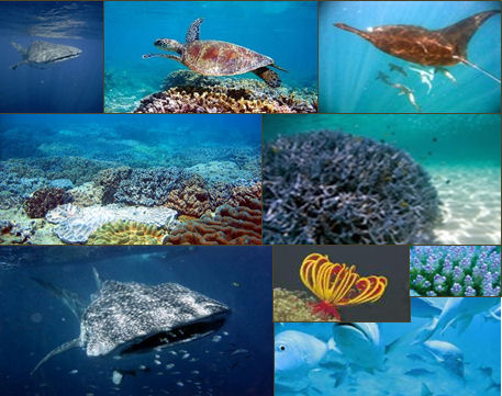
Figure 6 Flora and Fauna Species Biodiversity of Ningaloo Reef (Whale Shark, turtles, mana ray, fish spp. and coral spp.) (Sources: WA Dept. of Environment and Conservation and WA Tourism Commission websites, 2008)
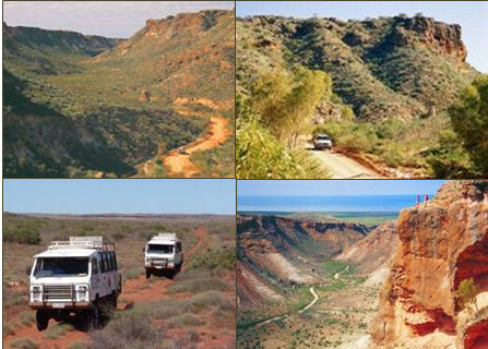
Figure 7 Shrub steppe and spinifex grassland vegetation of the Cape Range as displayed in the Shothole Canyon and Charles Knife Canyon areas (Sources: WA Dept. of Environment and Conservation and WA Tourism Commission websites, 2008)
Criterion (viii) Assessment and Findings
Outstanding or Superlative Examples of the Earth’s History
Five key conditions of Criterion (viii) are satisfied by the Ningaloo Coast’s display of outstanding or superlative examples of the earth’s history, including:
- the strong linkage to ancient Pangean and Gondwanan supercontinent and Tethys Sea origins demonstrating the continental drift theory through superb and rare examples of endemic and anchialine subterranean fauna, including the outstanding remipede species;
- tectonic elements, including:
- one of only two Afro-trailing edge type plate margins in the world (Hamilton-Smith et al, 1998, p. 15); and
- the processes of tectonic plate subduction and orogeny;
- a particularly outstanding example of an “emergent” landscape affected by uplift and sea level changes over long periods of geologic time as clearly demonstrated by the presence of four superb wave-cut terraces;
- rich fossil and sub-fossil occurrences that provide an outstanding record of the earth’s history, paleoclimatic phenomenon and past terrestrial and sea life, especially in relation to reef development;
- an outstandingly rich array of on-going geomorphic, karst, hydrologic and oceanographic processes, including:
- an extensive network of over 700 caves; and
- mesocaverns and anastamosing tubes extending down to an anchialine groundwater zone3.
Global Geological Themes Represented
The Ningaloo Coast provides evidence of 7 of the 13 UNESCO Global Geologic Themes (Dingwall et al. 2005), including:
- tectonic and structural features;
- stratigraphic sites;
- fossil sites;
- caves and karst systems;
- coastal systems;
- reefs, atolls and oceanic islands; and
- arid and semi-arid desert systems.
Our investigation has also revealed that Ningaloo Reef is not predominantly a “fringing reef” as has been commonly assumed and reported in many previous reports and publications. Ningaloo Reef totals approx. 282 km length with approximately 223 km of near-shore "barrier" reef (or what some marine scientists may refer to as a “bank barrier reef” and approximately 59 km of "fringing reef”.
This is demonstrated through the standard definitions of reef types (http://www.coris.noaa.gov/about/ what_are/ - v Reference:%20Intro%20to%20Marine%20Ecology and http://www.starfish.ch/reef/ reef.html). It is also illustrated by HyMap satellite image baythymetric map by Heege (2008) of Ningaloo Reef near Yardie Creek Australia, 2005 and through photographs and illustrations published by Collins, et. al. (2002, 2003 and 2006a). However, Ningaloo is a globally substantial coral reef of very high quality by world standards and the only significant reef on a western edge of a continent (S, A, E).
Criterion (ix) and Criterion (x) Assessment and Findings
Ecological/Biological Processes and In Situ Species and Biodiversity Themes
Criterion (ix) and (x) pertain to the ecological and biological processes and to the in situ species/biodiversity themes. Our findings show that the Ningaloo Coast meets these two criteria on the basis of the following processes and themes:
- Oceanic Currents and Nutrient Cycles, including for example:
- oceanography and unusual complexity of currents, water temperatures and bio-geographic regional influences;
- Marine Flora Speciation, Endemism and Refugia Processes, including for example:
- part of WWF’s Western Australian Marine Global 200 Ecoregion No. 212;
- a sponge biodiversity hotspot on the North West Shelf;
- a centre of endemism for rich biodiversity of marine species, including:
- at least 250 species of coral representing 54 genera of hermatypic (reef building) corals;
- 600 species of mollusc;
- 500 species of fish, and
- unknown number of sponge and other sessile species;
- 3 species of turtle and one bird listed as vulnerable;
- 13 species of seabirds listed on JAMBA and/or CAMBA recorded seaward of the outer reef;
- 3 species are listed as endangered (blue whale, southern right whale and loggerhead turtle).
- Ningaloo Marine Park is only one of two places remaining in the world where the whale shark (world's largest fish) regularly congregate and has the largest surviving whale shark community in the world;
- The reef’s fauna changes within short distances, ranging from tropical to temperate species;
- Terrestrial Flora Speciation, Endemism and Refugia Processes, including for example:
- part of WWF’s Carnarvon Xeric Scrub Global 200 Ecoregion No. 128 that has a Deserts and Xeric Shrublands Habitat Type classified as Critical/Endangered;
- outstanding species richness for an arid area (much higher species density than other WA regions- 288 spp. /1000 km2) with some endemism due to 2 overlapping tropical and temperate bio-climatic zones with many taxa at the southern-most or northern-most extent of their range;
- endemic, rare or otherwise protected flora and fauna species, some with genetic subdivisions of the same species north and south or east and west;
- a hotspot for non- marine mollusc endemism, with 10 such species known. These species were considered under-represented on the 2000 IUCN Red List and non-marine molluscs are known to be in global decline (Lydeard et al., 2004).
- part of WWF’s Carnarvon Xeric Scrub Global 200 Ecoregion No. 128 that has a Deserts and Xeric Shrublands Habitat Type classified as Critical/Endangered;
- Avifauna Speciation, Endemism and Migration Processes, including for example:
- 13 species of seabirds listed on JAMBA and/or CAMBA recorded seaward of the outer reef.
- Subterranean Fauna Speciation, Endemism and Refugia Processes, including for example:
- Cape Range is a centre of endemism and relictual taxa refuge for one of the world’s largest and most significant groups of terrestrial and aquatic troglobitic species surviving within a karst system, including fish, amphipods, isopods, remipedes, and insects;
- the only known example of a Remipede (Lasionectes exleyi) community in southern hemisphere (Humphreys, 1999b); a rich array of other rare, endemic and threatened stygobitic fauna, including fish, hadziid amphipods, gammarid amphipods, copepods and ostracods;
- the aquifer adjacent contains atyid shrimp, thermosbaenaceans, diverse amphipods and Ophisternon (the blind eel);
- Cape Range is a centre of endemism and relictual taxa refuge for one of the world’s largest and most significant groups of terrestrial and aquatic troglobitic species surviving within a karst system, including fish, amphipods, isopods, remipedes, and insects;
- Anchialine Groundwater Habitat Processes, including for example:
- a complex stratified anchialine hydrological environment that provides refuge habitat for the survival of one of the world’s most superb and diverse assemblages of unique and threatened troglobitic and stygobitic fauna species (Humphreys, 2000a and 2000b).
Cape Range is one of the most outstanding examples in the world of an arid karst site with high biodiversity and examples of species originating from the Tethyan Ocean. Regarding the subterranean and anchialine environments of Cape Range, only two sites within the classic Dinaric karst of similar quality and integrity to the Cape Range exist – Postojna-Planina and Vjetrenica.
Integrity
The Ningaloo Coast nomination property satisfies the UNESCO conditions for integrity in the following ways:
- The elements and the natural processes are highly intact and either relatively unaltered or capable of effective rehabilitation;
- The natural threats to Ningaloo Reef or anthropogenic problems have generally been (or certainly could be) obviated by proper management practice;
- However, impacts of petroleum and gas extraction, mining, pastoral grazing, feral animals, pest plants and recreation/tourism do exist; and
- Regarding integrity, significant features and processes of the four natural criteria could be further enhanced and more fully contain superlative features, phenomenon and processes of outstanding universal value associated with the property as a World Heritage Site.
We have considered the aspect of “integrity” requiring a property to “contain all or most of the significant natural elements and processes”. Although the current nomination boundaries undoubtedly contain many features and processes of World Heritage value and quality, some additional areas, features and processes that should be considered for inclusion or more extensive representation include:
- Exmouth Gulf and its areas of dugong and whale habitat;
- floodplain vegetation areas of the Exmouth Coast;
- seabird breeding islands of the Exmouth Coast;
- mangrove areas and lagoons of the Talandji/Tent Island Nature Reserve Areas;
- vegetation types identified by Beard (1990);
- sand dunes and plains geomorphological unit south of Cape Range National Park;
- the floodplains, alluvial fans and river valleys geomorphological unit (which has been completely excluded from the nominated property in the Learmonth area along the west coast of Exmouth Gulf);
- the entirety of the dissected anticlinal ranges unit and the karst cave and mesocavern system (of which approximately 50% lies outside the nominated boundary); and
- the complete groundwater system, including the entire freshwater lens, brackish intermediate water layer and adjacent sea water, including the seabed outflows.
In terms of integrity and infrastructure, the area must be:
- kept free from over-exploitation of the reef resources by sand mining, fishing and/or tourism industries or damage by boats associated with these industries; and
- protected from the collateral impacts of development, including clearing of vegetation, road construction, and hotel and marina construction.
The proposed boundaries do not fully comply with conditions of integrity as defined in the Operational Guidelines (UNESCO, 2008):
- particularly paragraphs 87-95, 99-107;
- no reference to a buffer zone. (In this regard, the Shark Bay World Heritage Site does not serve as an appropriate model.)
- Review of the core zone and an appropriately regulated buffer zone is strongly recommended:
- In particular, we have concern regarding quarry areas existing to the east of Cape Range National Park that could potentially affect ground water quality, having a relay-effect on biological functions and creatures located in the Marine Park and Cape Range;
- The potential effects of pastoral leasehold grazing on the Marine Park south of Cape Range National Park are also of concern due to what we regard as an inadequate 40 m onshore protected area within the Marine Park;
- The Exmouth Gulf area, or portions of it, should be considered for inclusion in order to take in the entire underground aquifer and freshwater lens, significant islands of the Gulf and the tidal and supertidal flats of Talandji (Giralia Bay to Yanrey Flats).
Although the important areas excluded at this time certainly do not diminish the universal outstanding value of those elements and processes that are included within the nominated property, they are of serious concern.
The current physical and functional integrity of the main geomorphic and physiographic elements and processes are exhibited within the nominated property and can generally be adequately conserved and monitored under joint World Heritage and regional authority co-operation.
Most coral reefs are seriously threatened (Cao and Caldeira, 2008; Walsh, 2008). Many are in poor condition in comparison to the near pristine condition of Ningaloo Reef. In addition, karst cave and mesocavern systems, such as those at Cape Range area, are extremely vulnerable to adverse human impacts. For these reasons, core area boundaries and buffer zones adequate to protect these resources should be the first step in ensuring appropriate protection and conservation management. Strong management is also vital to maintenance of positive health of coral reef systems.
Summary Conclusions
The nominated Ningaloo Coast property satisfies all four of the natural criteria for World Heritage inscription and compares highly with other similar karst and coral reef areas throughout the world.
However, there are important concerns about integrity and the inadequacy of the nominated property boundaries in terms of the core zone and the need for designated and regulated buffer zones as viewed within the context of the World Heritage Commission’s (2008) Operational Guidelines.
Contacts
Key contacts regarding the Ningaloo Coast World Heritage nomination property include:
- Jane Ambrose Assistant Director Natural Heritage West Natural & Indigenous Heritage Branch Department of the Environment, Water, Heritage & the Arts GPO Box 787 Canberra ACT 2601
- Tel: 612) 6274 2084 Fax: 02) 6274 2731 Email: Jane.Ambrose@environment.gov.au ;
- Dennis Williamson, Director, Geoscene International (A Division of Scenic Spectrums Pty Ltd), P.O. Box 1036 Glen Waverley, Victoria 3150 Tel. 613) 9803 6344 Mob. 0418 331 322
- Email: geoscene@scenicspectrums.com.au ;
- Professor Elery Hamilton-Smith, P.O. Box 36, Carlton South, Victoria 3053 Tel. 613) 9489 7785
- Email: elery@alphalink.com.au .
3.Mesocavernous limestone is produced by freshwater permeating the rock, so it usually occurs at the junction between rock beds or along the joints. But at Cape Range, given the distinctive character of the rock, it extends throughout almost the whole of the limestone, resulting in a spectrum of microclimates which in turn fosters the remarkable speciation which has taken place, as discussed under Criterion (ix) and Criterion (x) below.
References
Beard, J.S., (1990). Plant life of Western Australia. Kenthurst: N.S.W., Kangaroo Press 319pp. http://kbd.kew.org/kbd/detailedresult.do?id=361233
CALM, (2005). Management Plan for Ningaloo Marine Park and Muiron Islands Marine Management Area: 2005 – 2015. Management Plan Number 52. Prepared for Marine Parks and Reserves Authority Department of Conservation and Land Management.
Cao, L. and K. Caldeira, (2008). Atmospheric CO2 stabilisation and ocean acidification. Geophysical Research Letters.
Collins, L.B., (2002). Tertiary Foundations and Quaternary Evolution of Coral Reef Systems of Australia’s North West Shelf in Keep, M. and Moss, S.J. (eds.), The Sedimentary Basins of Western Australia 3. Proceedings West Australian Basins Symposium, Perth, Western Australia, pp. 129 – 152.
Collins, Lindsay B., Rong Zhu, Zhong, Wyrwoll, Karl-Heinz and Eisenhauer, Anton, (2003). Late Quaternary structure and development of the northern Ningaloo Reef, Australia in Sedimentary Geology, Volume 159, pp 81 – 94.
Collins, Lindsay B., (2006). Ningaloo Reef and Hinterland: Geology and Evolution. Poster Abstract in International Field Meeting on Sub-Aerially Exposed Continental Shelves Since the Middle Pleistocene Climatic Transition. INQUA Project 0419/IGCP 464. 13 – 18 August. Curtin University of Technology.
Dingwall, Paul, Tony Weighell and Tim Badman, (2005). Geological World Heritage: A Global Framework. A Contribution to the Global Themes Study of World Heritage Natural Sites. Prepared for The World Conservation Union (IUCN) and the World Commission on Protected Areas (WCPA).
Hamilton-Smith, Elery, Kevin Kiernan and Andy Spate, (1998). Karst Management Considerations for the Cape Range Karst Province, Western Australia. Prepared for the Western Australian Department for Environmental Protection (March).
Hamilton-Smith, Elery and Williamson, Dennis, (2008). Ningaloo Coast World Heritage Nomination: Background Paper for Comparative Analysis. Prepared for Heritage Division Department of Environment Water Heritage and The Arts (DEWHA) Australian Government (December).
Heege, Thomas, (2008). Hyperspectral seafloor mapping and direct bathymetry calculation in littoral zones. In Encora: Coastal Portal http://www.coastalwiki.org/coastalwiki/Hyperspectral_seafloor_mapping_and_direct_bathymetry_calculation_in_littoral_zones
Humphreys, WF, (2000a). Karst wetlands biodiversity and continuity through major climatic change – an example from arid tropical Western Australia. Pp. 227-258. In: Gopal, B, W.J Junk and J.A Davis (eds.), Biodiversity in wetlands: assessment, function and conservation, volume 1. Backhuys Publishers, Leiden. 353 pp.
Humphreys, W.F., (2000b). The hypogean fauna of the Cape Range peninsula and Barrow Island, northwestern Australia. Pp. 581 – 601. In: Wilkens H., Culver, D.C. and Humphreys WF (eds). Ecosystems of the World, Vol. 30. Subterranean Ecosystems. Elsevier, Amsterdam.
INQUA, (2006). Abstracts for International Field Meeting on Sub-Aerially Exposed Continental Shelves Since the Middle Pleistoscene Climatic Transition. Collins, Lindsay and Alexandra Stevens (Eds.), INQUA Project 0419/IGCP 464. International Union for Quaternary Research 13-18 August, Exmouth, Western Australia.
Kendrick, Peter and Roland Mau, (2002). Carnarvon 1 (CAR1 – Cape Range subregion), Western Australian Biodiversity Audit. Department of Conservation and Land Management.
Lydeard, C., R.H. Cowie, W.F. Ponder, A.E. Bogan, P. Bouchet, S.A. Clark, K.S. Cummings, T.J. Frest, O. Gargominy, D.G. Herbert, R. Hershler, K.E. Perez, B. Roth, M. Seddon, E.E. Strong, F.G. Thompson, (2004). The Global Decline of Nonmarine Molluscs in BioScience, Vol. 54, No. 3., pp. 321-330.
Scenic Spectrums Pty Ltd, (2007). Wulong Karst in the South China Karst Region: Assessment of Qualifications - World Heritage Criterion (vii) And (viii) by Dennis N. Williamson, Director.
UNESCO, (2008). Operational Guidelines for the Implementation of the World Heritage Convention. United Nations Educational, Scientific and Cultural Organisation and Intergovernmental Committee for the Protection of the World Cultural and Natural Heritage (January). UNESCO World Heritage Centre: http://whc.unesco.org/en/guidlines (English).
Walsh, B., (2008). Coral Under Siege. Time, August 4th, pp. 28-29.
Western Australian Dept. of Planning and Infrastructure, (2004). Ningaloo Coast Regional Strategy Carnarvon to Exmouth. Final. Prepared by WAPI for the Western Australian Planning Commission (WAPC) August.