Winds of Change – A Karst Management Database
Abstract
The Australian Speleological Federation (ASF) created the Australian Karst Index in 1985. Today cave managers have little more than that 1985 karst index on which to base management decisions.
What is required is a Karst Management Database that is designed to hold not only the basic information about a cave or karst feature such as cave length, depth etc but also to hold details of everything relating to every karst feature that they manage. The database should hold ALL research information that has ever been undertaken for every cave and karst feature. The database should also classify this information so that at any time a Cave Management Prescription for any cave or karst feature can be generated by the database using ALL of the management information that is available at the time of generation.
Such a Karst Management Database is being designed to collate all fields of research including geology, archaeology, palaeontology, aboriginal heritage and site information etc It would also contain general data such as maps, photographs, videos etc, all related to one or more karst features. This paper outlines the design of the database and how it will be build to simplify a cave managers job of collecting the varied data that is required to make informed decisions about the caves and karst features that they manage.
Do we Need a Karst Management Database (KMD)?
The concept of a Karst Management Database (KMD) is one that has built over time. More and more information relating to caves and karst features is being discovered by researchers, speleologists and managers. This large quantity of knowledge is required by cave managers if they are to make knowledgeable decisions about the present and ongoing management of caves and karst features. Unfortunately unless this quantity of knowledge can be harnessed by an appropriately crafted database, decisions relating to the ongoing management of caves and karst are likely to be made on the basis of “best available local knowledge” or the results of extensive literature surveys. This has been the case for all current cave managers in Australasia for over 30 years. Other countries appear to have similar problems, as a search of the internet returned zero results for “Karst Management Database”.
Examining the “databases” on the http://www.karstportal.org website shows NO databases containing karst management data. These databases generally contain basic information such as the caves location, name, length, depth and short description. The most extensive online database in the world appears to be the Australian Karst Index Database (KID) based on the 1985 dataset. Fleury et al (2007) describes the Karst Information Portal as
“ the integration of karst knowledge by providing a comprehensive, community-driven central repository of this knowledge, including gray literature, raw data, and published journal articles.”
Unfortunately this portal does not provide a database that cave managers need to adequately manage their caves.
The lack of a KMD appears to be a global problem so the development of such a database could see it used on a global scale. Certainly it has the prospect of being used Australasia wide.
What Information should be in a KMD?
It is clear that a KMD should provide cave managers with a tool that can access data relating to every aspect of cave and karst management. So here is some of the data that I think should be in the KMD.
The Basic Information
The basic cave information is the basic dataset that is currently stored in the Australian KID. Information such as the cave Name, Number, Length, Depth, water flow etc. This level of information provides little to cave managers that they could base management decisions upon.
So the next level of detail which should be considered basic cave management information is at least the following:-
- Hazard Information with ratings
- Visitation rates per/week and/or per month or year
- Maximum and Minium Party Size
- Booking Information (AM/PM/DAY)
- Cave Classification
- GPS Location information
Examining this basic level of cave management information it provides managers with the basis of a permit system that will allow them to make decisions about controlling access to caves and karst features. Managers will still need to use “local knowledge” to determine many of these critical values which all have the possibility of badly affecting caves if they provide excessive access to caves. As managers if you are unsure on visitation rates or party sizes always err on the side of lower numbers and provide caves with lower impacts.
Hazard Information with ratings
One of the items in this basic information is Hazard Information. Any potentially known hazardous sites within a cave need to be assessed and rated. A simple rating system should be used such as that shown in Table 1. This example uses a range of numbers to rate the stability of a rockfall with 1 being the most stable and 10 being the most unstable. Only those hazards that are thought to pose a risk should be rated with other rockfalls in the cave falling into the 1-2 rating which specifies that care is required at all times on rockfalls.
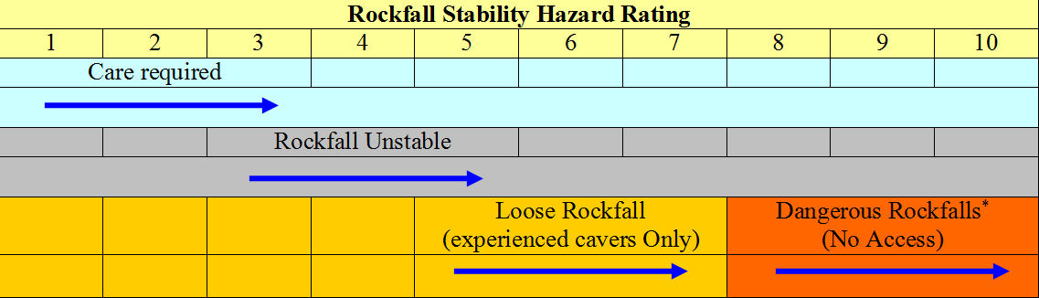
Table 1 * - No Access – These Dangerous areas should only be accessed to be re-assessed by appropriate Staff or Consultants.
By developing simple hazard ratings for all cave hazards and then rating those hazards for each cave the KMD could be used to provide cave permits that could easily list the hazards, with ratings, on each cave permit. The generation of cave management prescriptions (Webb, 1999) could also be automated using the KMD containing this level of data.
Kowallis (2009) provides a methodology for “rating a cave” by identifying the hazards in a cave, giving the hazard a rating (in the form of a range) and then “estimating” the “possibility of occurrence Factor” to determine an overall “Hazard Rating” for the cave. This system provides a method of determining the overall risk rating for the entire cave by taking all of the known hazards in the cave into account. This system could provide overall Hazard Ratings for each cave in a KMD. However Kowallis’s hazard rating does rely on the “possibility of occurrence Factor” which is purely an estimate based on one or more persons “local knowledge” and “gut feeling” on how bad a particular hazard is? In some cases this may have some statistical basis, such as flooding where it may be based on the number and size of past flood events but this will not always be possible.
The …LOGICAL information
This set of data is the largest set of those proposed for the KMD. Some parts of this dataset are currently in the ASF KID database but they are poorly represented. The …Logical information refers to the many fields of science that relate to caves and karst that end in the suffix –logical, and some that don’t. Table 2 lists the –logical data areas that relate to caves and karst.
| Dataset |
| Geological Feature data |
| Biospeleological data |
| Hydrological data |
| Archaeological data |
| Palaeontological data |
| Meteorological data |
| Microbiological data |
| Cultural Heritage data |
| Cave Inventory data (Speleological) |
Table 2
All of these datasets would require rating information similar to that specified in Table 1 for rating Rockfall Stability Hazards. However for the datasets in Table 2 the ratings would relate to the rarity of the cave feature, cave animal, hydrological feature, fossil, etc. The suggested rarity ratings for cave and karst features are shown in Table 3.
In order to fully specify the importance of a feature it would be preferable to specify the rarity on a State, Country and Global scale. By using all three rating levels, it would be possible to specify all of the features in caves and karst for an area at the State, Country and Worldwide levels. This method of scaling would highlight the importance of features in caves and karst from all perspectives and would ensure that managers could readily highlight the critical features in their area which would require higher levels of protection. These features could also be readily highlighted when Cave Management Plans and prescriptions are prepared. This level of rating would also be highly valuable when documenting caves and karst for major submissions such as World Heritage listing.
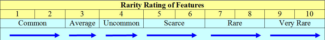
Table 3
The actual data fields that would be stored for all of these datasets would clearly be different with different information requirements for each dataset. The database design would readily allow for the different data fields for each dataset and would allow other, as yet unspecified datasets, to be added to the database at any time.
Infrastructure Info
Other types of data could also be added to the database that would greatly assist cave managers in maintaining the infrastructure within, on or nearby caves or karst features. Infrastructure tables could be maintained that recorded infrastructure details such as:-
- Tourist Cave Infrastructure – Stairs, Platforms, Lighting, Gates etc
- Non-Tourist Caves – Bollards, Abseiling structures, hardened walkways, signs, track or route marking, ladders, etc
- Scientific Equipment
- Buildings – Toilets, Water Tanks, Generators
- Car Parks, Interpretive Centres etc
Details such as Location, Size, Materials, Date Constructed, Cost, Supplier, Warranty, Maintenance Schedule, Damage or Wear and Tear notes etc could all be stored in the database. This would allow cave managers to generate comprehensive maintenance reports and schedules on all of the infrastructure that they need to maintain. The database would also accommodate any other infrastructure items that cave managers may need to add and maintain.
Permit Information
Currently cave permit software called TripMan has been developed and is operational at Yarrangabilly in New South Wales. The TripMan software allows cave managers to store the basic information required to generate cave permits for cave leaders who have the required access levels to visit caves under their management. Managers can ensure that the visitation levels they require are enforced via the TripMan software. This software also allows leaders to request their permits online with appropriate authorisation being supplied by management staff.
A KMD would have the ability to store considerably more information about all of the different types of permits that cave managers are required to issue in relation to a variety of cave and karst activities. Table 4 lists a number of different types of permits that managers would be expected to deal with in respect to the caves they manage. All managers may not require all of these permit types but many of them apply to most managers at some time.
| Permits for Cave and Karst |
| 1.Permits to collect cave fauna by cave, karst area or state? |
| 2.Permits to visit caves – (Current TripMan system) |
| 3.Permits to conduct experiments in caves |
| 4.Permits to perform digs to enter or extend caves |
| 5.Permits to perform Palaeontological or Archaeological digs in caves |
| 6.Permits to collect speleothems and other deposits from caves |
| 7.Permits to dive in caves |
Table 4
The list in Table 4 is by no means comprehensive but the KMD should readily accommodate any type of permit that you may wish to authorise. Each type of permit could be defined in the database and then the permits could be issued at any time by the appropriate staff. The database would maintain an ongoing record of all permits provided along with any conditions that were applied to any permits.
Fire Information
Another area of management that would benefit from a KMD is fire information in karst areas. The generation of maps showing known cavernous areas is very important when planning firebreaks and in emergencies, where new fire fighting breaks can be placed, while ensuring the safety of dozer operators. Keeping heavy equipment away from known cavernous areas is sometimes not possible but if appropriate planning has been undertaken then the risk to operators of heavy equipment can be minimised.
Use of the KMD in conjunction with GIS mapping software would readily allow the generation of sensitive cavernous areas for use in fire planning. It would also allow the generation of definite “no go” areas for heavy equipment. Highly sensitive sites that may be vulnerable to fire, could also be identified in the KMD so that special planning requirements are applied to these sensitive karst sites.
Maps showing known cavernous areas could also be extrapolated using known hydrological information to include “possible” cavernous hazards that would only be entered with heavy equipment in cases of emergency.
The KMD would store information about sensitive sites and areas along with a sensitivity rating similar to the “rarity” rating shown in Table 3. These ratings could then be used to highlight those areas or sites with the highest sensitivity and ensure that the most sensitive sites received the highest level of protection.
What is the Extended KID?
In Australia the ASF KID database is currently the database with the most basic information available. Other databases have been created such as the South Australian KIDSA database of the Nullarbor which contains many more data items than the current ASF KID. The WA KID database also extends the data stored by the ASF KID by also providing fields that store the information listed in Table 5.
| Extended KID Data |
| Cave Maps in Image form |
| Cave Images |
| Cave Videos |
| Trip Reports |
| Fossil Data |
| Environmental Data |
Table 5
All of these data objects and more could readily be added to the KMD which would make this database the most comprehensive karst database ever built.
Database Design and Software
Without entering into extensive detail of how the database would be designed and operated the overall design for the development of the KMD will be described.
An SQL server database would be used as the major data store for all of the information in the KMD. The exact “flavour” of the SQL server software is not considered critical but would almost certainly be either Microsoft SQL server (2008 at present), Oracle (11g at present) or MYSQL (5.1 at present). All of these products provide a database which would ensure that the KMD could grow rapidly over a 10-15 year period with only maintenance and upgrades to consider.
The development of the web based application would be the heart of the KMD. To ensure that the application is robust and can be maintained in a corporate environment, the appropriate development environment is Microsoft’s ASP.Net.
The database table design would be based on objects, which are in fact the field names and types that make up the design for a specific object type. The object would be the Basic Cave information or the Geological feature data, and the objects would have a relationship table which would allow objects to be related to each other in any number of ways. The forms that allow users to input and change data in the database would be stored in the database as an XML field. The XML form would be read from the database when a form needs to be loaded and the data displayed to users in a web browser.
This design would allow new objects to be easily added to the KMD at any time with minimal or no input required from programmers.
Who Would Use a KMD?
The users of a KMD would be wide and varied but the main list of user groups are specified in Table 6. All of these groups have an interest in caves and karst. Their interests may vary wildly but they all require the same thing and that is information about caves or karst features in a particular area or region. They may be proposing a development on karst and need to know how to avoid caves and karst features, or they may be looking for a cave to undertake specific research. No matter what purpose the group has they need up to date and accurate information on caves and karst. The KMD software will allow cave managers to provide different online levels of access to the KMD. Different views of the data can be provided to each user group or even individual users.
This would allow cave managers to ensure that the data could be secured while still giving appropriate levels of access to a large variety of user groups.
| KMD User Groups |
| Cave and Karst Managers |
| Researchers in Cave and Karst |
| Speleologists |
| Government Departments |
| Cave Rescue Organisations |
| Property Developers |
| Mining Companies |
| Telecommunication Companies |
Table 6
What Would they Access?
The importance of security over access to the database cannot be overemphasised but using the current software tools it is relatively easy to provide access to a very wide range of views of the KMD without compromising the data.
Researchers could easily be provided with update access to their relevant areas of expertise without compromising the overall integrity of the KMD. Speleologists could be given access to the KMD to allow them to provide cave surveys, inventories, images, Trip Reports, or any other data area that cave managers deemed appropriate.
Overall the levels of access would be created, specified and managed by the cave manager ensuring that data access would be provided to user groups to ensure that it was used or updated in a timely and appropriate manner. If required the KMD could be configured to ensure that cave managers reviewed updates before they were applied to the KMD.
What Cave Managers Could Produce
Cave managers have requirements to produce a range of different reports relating to the karst areas that they manage. A range of possible reporting requirements for the KMD are outlined in Table 7 but many more are possible and could be defined in the development process.
With built in configurable logic the automated generation of Cave Management Prescriptions would allow cave managers to generate up-to-date prescriptions at any time. As new information is added to the KMD prescriptions would automatically change as critical information changed.
The levels of reporting would need to be highly flexible so that additional reports could be generated by cave managers without reverting to the need for programmers to generate new reports.
| Reporting Requirements |
| Visitation Data for Caves and Karst Areas – Daily, Monthly, Annual |
| Vital Cave and Karst Information for regional management plans |
| Cave Management Prescriptions (automated) |
| Cave Maintenance Work flows (automated) |
| Fire and Rescue planning data |
| Permit Renewal data |
| Details of outstanding data not entered |
| GIS details of caves and karst areas |
Table 7
Who Would Enter the Data?
Initially a significant quantity of basic cave data could be imported from existing data sources such as the ASF KID and other databases and spreadsheets held by speleological groups. However a major portion of the data is currently held in research organisations such as Universities, Museums and private companies. The developer of the KMD would need to liaise with these organisations to request access to the data they hold, to allow importing into the KMD. Reciprocal arrangements with these organisations should see them access to the KMD to extract information, as well as, to update their specific areas of research or knowledge.
Where cave managers have provided access to caves for researchers or speleologists they should be required by the permit they are given to place the results of their research into the KMD. Where the research is sensitive or confidential researchers should be able to request a caveat be placed on access to the information by the cave manager. This form of cooperation should ensure that important data that may affect the management of a cave or even a site within a cave is not overlooked because the information is not available to the cave manager.
Permit applications could be entered ,via the Internet, by those requesting/renewing a permit but all permits would be authorised by appropriate staff. This process could be fully electronic or involve the generation of hard copy permits if required.
Who Should Manage the KMD?
Management of the KMD should be the responsibility of the government agency managing the caves and karst. In Australia there are about 20 or more agencies/organisations/private companies that are currently managing caves. However of these bodies the one that has more karst and more caves than any other to manage in DEC in Western Australia. With the majority of the Nullarbor, Cape Range and the Kimberley providing over 8000 caves and karst features it is imperative that DEC starts to collate the large quantity of data that is required to manage these significant cave and karst resources. The creation of a KMD should become a priority for DEC as the first of these areas moves towards World Heritage listing.
Once the KMD has been built its use could readily be extended to other cave managers and karst areas throughout Australasia and hopefully the world. No such database currently exists but it should. If cave managers are to truly manage the caves they are custodians for they need extensive up to date information. The way to bring this information to cave managers is with a comprehensive KMD.
Conclusion
The paper describes a comprehensive KMD that would provide cave managers with the ultimate data store for cave and karst information. The database would be flexible enough to allow any data items relating to caves and karst to be defined, stored and retrieved by the database.
If DEC in Western Australia were to build such a KMD then it is very likely that other cave managers would be interested in using the database to store the data relating to the caves and karst that they need. Besides interest from Australasia it is very likely that other countries cave and karst management authorities would also be highly interested in utilising such a KMD.
Let’s plan for the future and build a KMD that will ensure caves and karst will have a database that will provide cave managers with the best chance of making informed management decisions. Hence they will be able to make those decisions because they have the best information available.
References
Fleury E. S., G. Veni, T. Chavez, P. J. Boston, D.E. Northup, H. L. Vacher and P. Seiser. (2008). Superior Karst Stewardship through Superior Data Management: The Karst Information Portal. Proceedings of the 18th National Cave and Karst Management Symposium. St Louis, MO. Edited by William R. Elliott. pp 290-294.
Kowallis B. (2009) The Cave Hazards Rating System. NSS News (Submitted for publication). http://www.brandonkowallis.com/Resources/CavePrograms/CaveRatingSystem.htm
Webb, R. (1999). Cave Management Prescriptions – An alternative to Cave Classification Systems. In Henderson, K and Bell, P., (eds.) Proceedings of the Thirteenth Australasian Cave and Karst Management Association Conference, Mount Gambier, South Australia, April 1999, Australasian Cave and Karst Management Association. http://www.ackma.org/papers/cmprescriptions.html
List of Abbreviations:
| Abbreviation | Meaning |
| ASF | Australian Speleological Federation |
| ASP.Net | Active Server Page.NET – Development environment for WWW pages. |
| ACKMA | Australasian Cave and Karst Management Association |
| DEC | Department of Environment and Conservation (Western Australia) |
| GIS | Geographic Information Systems |
| KMD | Karst Management Database |
| KID | Karst Index Database |
| SQL | Structured Query Language |
| XML | Extensible Markup Language – used to share structured data. |