Interpreting the Mount Gambier cenotes (sinkholes) within the Kanawinka Geopark
Latrobe University (Bendigo Campus), Cave Exploration Group of South Australia, Cave Divers Association of Australia
Cenotes of the Limestone Coast
Note: Throughout this paper the term "cenote" is used, for although the general local name for these features is "sinkholes", it is the cenote form which is geologically unique.
The South East of South Australia is a vast karst plain of flat-bedded "soft rock" tertiary limestone which is shallow 200kms inland around Bordertown and Kingston, but gradually deepens towards the sea south of Mount Gambier and which contains over 1000 caves. These features together with the rugged coastal cliffs, the terra-rossa wineries of Coonawarra and the extensive use of limestone ashlars for local buildings have given the region its tourist name - "The Limestone Coast" - which has become a very successful tourism and marketing strategy and a great choice of name.
Of the 1000 caves, there are several hundred sinkholes of all shapes and sizes. The thirty or so which contain water directly beneath their entrances are known in karst terminology as "cenotes" - large circular vertical-sided pits dropping into clear dark freshwater lakes. They occur in the deeper limestone zone from Mount Gambier to the southern sea coast, and more may continue offshore although now drowned and possibly sanded by the sea.
They are mysterious and controversial. Cave divers have died in them in earlier decades (Lewis and Stace 1980). Hell's Hole may be the largest cenote in the world. A number of cenotes have been used as rubbish dumps with some since cleaned and rehabilitated. They contain an array of biotic life, some species of which are unknown elsewhere. Even the term "cenote" is a conflict of various unresolved definitions. Cenotes occur on private property, forests and farm lands with a corresponding diverse mix of landowners.
Locally known as "sinkholes", the cenotes have acquired a sinister reputation as "killer holes" due to the drownings of 13 scuba divers exploring vast water-filled caverns beneath them over a period of 5 years in the 1970s. This little-deserved reputation has retarded public appreciation of the uniqueness of these features and until more recently has obscured the interesting scientific and historical information being collected by cave divers on research projects.
Why the term "cenote"?
The term "cenote" (pronounced say-noh-tay) is of Mayan origin and is used to describe similar features in the north-eastern province of Yucatan, Mexico. The word loosely means "natural well" and has been used to describe thousands of the karst features across the Yucatan limestone plain which led to water below. Maya settlements began over 3000 years ago and some cenotes became the focus of later Mayan cities. The most famous cenote is Chichen Itza, the large and terrible circular well into which so many human offerings were sacrificed over the centuries (Thompson 1938). Many more are found in the Caribbean islands and those drowned by the sea there are known as Blue Holes.
As the first cenotes were described by early archaeologists investigating the remains of the Maya civilisation (Mercer 1896), karst terminology has absorbed the term "cenote" for these generally cylindrical features. As such it can be applied to the identical features of the Gambier karstfield in South Australia. The common local name of "sinkholes" in the Limestone Coast is applied to all depressions, wet or dry, along with some circular draining areas, small swamps, runaway holes as well as the cenotes (Lewis 1976).
When is a cenote not a cenote?
Different definitions and descriptions exist; (i) cenote is a term used by the Maya for any subterranean chamber that contains permanent water (Thompson 1938), (ii) a cenote is a partly water-filled wall-sided doline (Marker 1975), (iii) cenotes are formed by the collapse of a cave which is currently filled with water (Duckeck 2007). A well-known Mount Gambier feature illustrates the confusion - Umpherston's Cave is not a cave but a sinkhole in local terminology. It is currently dry, so it is not a cenote, but had a lake for the last 120 years when it was a cenote! Its geology has not changed and only the water has gone, so is it still a cenote or not? We need to decide, as it is a prime geological tourist feature of the city and the Kanawinka Geopark (fig 1).
The three examples in fig 1 also illustrate one of the debates over the definition of a cenote - the original Mayan use of the name would include all three types, some karst geomorphologists would only apply it to Little Blue, while others would also include Bullock Hole but not The Shaft as it only has a solution pipe entrance!
Cave diving in the Mt Gambier cenotes
The Mount Gambier cenotes have an international reputation for spectacular cave diving conditions in crystal clear water, deep and massive submerged caverns and a range of differing types. They all have easy vehicle access on farmland or in forests, compared to jungle conditions in the Yucatan or boat access to the Caribbean Blue Holes.
Water temperatures are fairly constant at 15°C. Daylight directly floods the large chambers or is filtered through a pale green curtain of algae which is present at certain times of the year in the upper layers of the water. Divers may visit a specific cenote several times before they can develop a true appreciation of its size, shape and direction.
Geology - the collapse process and giant chambers
Some of the large passages are gigantic, where a cave diver is like a fly on the wall. The large volumes of limestone have presumably been removed by solution as divers have found no evidence of streamways at depth (Lewis 1984). These might have been expected during the Pleistocene when sea levels and the aquifer surface level were 120 metres lower than the present day and the climate was considerably wetter (Grimes and White 2007). An old concept was that past lower water tables weakened the limestone by dissolving multiple horizontal phreatic layers at different depths in the cenotes causing their collapse. This has never been substantiated as divers have never observed such layering effects in the walls of any cenote at any depth.
Progressively the roofs of the chambers collapsed forming large boulder piles. Individual rock slabs can be enormous - bigger than a house in some cases. The bottoms of Ten-eighty Sinkhole, The Black Hole, The Bullock Hole and The Shaft all show this effect. Eventually more roof collapsing occurs until the cavern breaks through to the surface above, forming a typical cylindrical pit with a lake - the true cenote shape. Little Blue Lake is an excellent example (fig 2).
The cave diver mapping programmes show the collapse sequence (fig 1). The surface gives no indication of the vast passage system in The Shaft and the tiny lake was only revealed in the 1930's when a small solution pipe broke through after the landowner's horse shied away from the ground. Collapse of the overhang there will open the cavern to a cenote profile (e.g. Bullock Hole) while possibly part-blocking deep lower passageways with massive rock collapse. Likewise, the Bullock Hole entrance will enlarge by collapse producing a circular cenote similar to Little Blue.
Most of the deep cenotes are found in one area west of Mount Schanck, in the zone of greatest concentration of faults and joints (Marker 1975). The limestone here is over 150 metres thick and the large deep passage at the bottom of The Shaft approaches 120m depth, accessed by divers using new mixed-gas breathing technology (T Payne pers com 2007). Cenotes close together are likely to be roof collapses into a single long deep passage system beneath.
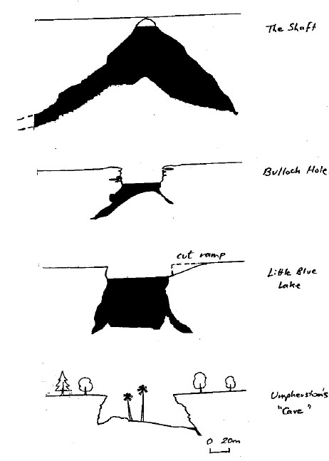
Figure 1
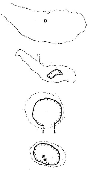
Figure 2
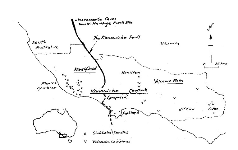
Figure 3
What's at the bottom?
The floors of most cenotes are rock collapses, sometimes covered with sand and silt cones from surface soil or old dune infills such as in the walls of Hell's Hole. Trees are found at the bottom but on examination it appears that most of these were pushed in by early settlers clearing the land. Later additions of car bodies, dead sheep and coils of wire etc provide ample evidence of 150 years occupation of the area by Europeans - not a distinguished record.
More interesting items range from a wooden hay rake complete with original iron wheels sitting in 25 metres of water, various road signs, training lines for cave divers, an old International truck cabin, an Austin utility, a Morris 1100 and a butter churn.
Scientifically the cenotes contain extensive arrays of stromatolites from the surface down to more than 30 metres (Thurgate 1996). These bio-geo growth forms are common in cenotes but rare across the world, being more renowned as a marine form (eg at Monkey Mia in Western Australia). Huge specimens are also growing up the walls of Mount Gambier's Blue Lake crater from more than 20 metres depth continuously to the surface. In local cenotes only a very few stalactites have been found below water, in complete contrast to the prolifically-decorated cenote passages of Yucatan and the Blue Holes.
A rare aquatic species - syncarids - have been found in abundance throughout the waters of the cenotes and caves along with many small freshwater sponges at all depths, sometimes in dark zones (Horne 1988). Introduced redfin perch have grown to good size in the shallows of some cenotes, sharing space with water boatman aquatic beetles. Recent studies on the water chemistry have identified variations in calcium and other ion precipitation rates depending upon temperature and seasonal exposure to sunlight. Some fossils have been recorded in deep water but the best concentration has been found in a shallow cave entrance pool - not a cenote but a cave by karst terminology.
The aquifer and the spectacular springs
The water occupying the cenotes is an "unconfined aquifer" which does not operate under pressure as it is exposed to the atmosphere in cenote entrances and swamps. It is directly filled from rainwater and surface soakage and moves slowly southward through the limestone to several coastal springs (Waterhouse1977). The biggest of these is Ewens Ponds - three 10m deep springs which are flooded basin-shaped dolines. The second-largest discharge is at Piccaninnie Ponds, an 80m deep rift in a complex coastal system and which was a huge spring in past geological time. These ponds would be "cenotes" in Mexican terms but not as defined by karst geomorphology.
Both Pond systems are world-renowned freshwater diving sites within National Parks. The excellent visibility of the water is due to the dissolved carbonate chemicals that naturally occur in it. These act as nuclei for attracting silt particles together, which then sink to the bottom. This clears suspended silt from the water and gives rise to the powdery silt layers on the ledges, walls and floors of the sinkholes.
... and an alternative theory ...
Scientists have their ideas about the cenotes, but people who lived in the areas well before settlement had a different perspective. In the folklore of the Boandik tribes, the following explanation is given -
The story is set in the aboriginal dreamtime period when a giant man called Craitbul and his sons lived in the area we now know as Mt Muirhead near Millicent, west of Mount Gambier. The men lived for a long period in this region digging in the ground for food with their bare hands and sticks. What they collected they then cooked over a large oven which they made (the volcano of Mt Muirhead).
One night they were attacked by their enemy and fled east to a new area where they felt safe once again. They constructed a new oven and began digging for food once more, creating the sinkholes we know today. However one day they found to their alarm that the oven fire had gone out because it had filled with water (the Blue Lake crater in the Mount Gambier volcano). A further oven was dug by Craitbul but it also filled with water (probably the Valley Lake crater in the Mount Gambier complex).
Two more ovens were made nearby (Mount Schank) but they too were extinguished and drowned out, leaving Craitbul and his sons so dejected that they left the area in search of a place where they might live undisturbed, but no one knows where that place is.
Nomination and philosophy of the Kanawinka Geopark
UNESCO retains a listing of approximately 150 Geoparks across the world, mainly divided between China and Europe but with an increasing range in other countries as the concept gains in popularity and nominations are put forward. Recently the western Victorian Volcanic Trail extending into the South East of South Australia has been nominated as Australia's first Geopark (fig 3). An international assessment team visited the region in mid-2007 and confirmation may be at the first International Geotourism Conference to be held in Perth WA in August of 2008.
During the assessment trip a frequent question by locals was how the declaration of such a park would further restrict them in the use of their land. The reply was consistent - the Geopark is a concept, not a legal delineation, and that owners of geological features of significance could involve themselves in the Geopark or not as they choose - there is no obligation or power of overrule. UNESCO does not want to restrict land use - the underlying philosophy is to use geological features to encourage local initiative and develop business opportunities around geological themes for the benefit of their communities (McKnight et al 2007 - see this issue).
Volcanoes and karst
The initial nomination theme was based on the Volcanic Trail until it was realised that the western end of the volcanics (in South Australia) had emerged through another major geological feature - the vast limestone plain with its 1000 cave and karst features. This contains world-class cave diving attractions, the distinctive cenotes and the World Heritage Naracoorte Caves fossil deposits, all of which contribute to the naming of the region for tourism purposes as "The Limestone Coast". Strangely the World Heritage Caves at Naracoorte are not included within the nominated Kanawinka Geopark, being a few kilometres to the north of the boundary.
The cenotes have long been recognised by cave divers, but rather less so by the local population until more recent years when water pollution issues have drawn more community concern and attention. An interesting geological link between volcanoes and cenotes is a developing theory that deep volcanic gas rising through the groundwater has acidified it in the zone where the most concentrated cenotes have developed around the Mount Schank volcano, Australia's youngest at 4000BP (Lewis 1984, Webb 2001).
The most obvious link between the volcanics and the karst is the famous Blue Lake at Mt Gambier, a large volcanic crater which was punched through the underlying limestone creating a beautiful large lake revealed as the surface of the aquifer. It is the region's tourism icon.
Why the name "Kanawinka"?
Running diagonally across the Geopark region and almost dividing it is a large and ancient fault line - the Kanawinka Fault. In general terms, it separates the volcanic uplands and plateaus which contain most of the Volcanic trail in Victoria in the east from the limestone plain and lowlands to the west in South Australia. It is therefore an excellent focus across the Geopark and very appropriate to select its name for the task.
The Kanawinka Fault is far older than the volcanoes and the limestone but through periodic reactivation has developed a modern-day scarp varying in height from 10-100 metres in height running for more than 100km from Naracoorte in the north towards Portland in the south where it joins a series of smaller high faults that extend the scarp to the sea. Its movement is partly responsible for the origin of the major Naracoorte Caves (Lewis 2008).
The name Kanawinka was applied to the faultline by a renowned geologist who assessed the regional geology from Portland to the Victorian border near Naracoorte in the 1950s (Boutakoff 1963). He used the name of a prominent local property "Kanawinka" homestead which lay on the line of the fault approximately halfway along its length.
In turn, the word Kanawinka has been interpreted from its Aboriginal origins as meaning "The Land of Tomorrow". There is no available explanation as to what this interpretation actually means, but it is generally taken as an expression of forward-looking optimism, also appropriate to the nomination of Australia's first Geopark.
Human interaction with the limestone and the cenotes
There are some obvious examples of human use of the limestone apparent from a general drive around the Limestone Coast region - white limestone roads, extensive use of large creamy-coloured limestone ashlars for building stone, quarries and roadside scrapes, and several tourist caves - Tantanoola Cave, Umpherston's Cave, The Cave Gardens, Englebrecht's Cave, Princess Margaret Rose Cave and the World Heritage Fossil Caves at Naracoorte.
Of vital importance is the vast freshwater aquifer underlying the whole karstfield, which has defined the use and appearance of the region. This allowed regional-scale human development of rich dairying, grazing and cropping farmland, a major softwoods forest industry and a proliferation of quality vineyards. The Blue Lake is the water supply for the City of Mount Gambier, the largest city in the Kanawinka Geopark.
One adaptation of the cenotes are sloping stone access ramps which were hand-cut or blasted into the circular sides of them in early years for stock to access the water, damaging the original circular cenote shape although not obscuring them (fig 2). It did not occur in the Mexican cenotes of the Yucatan, so this is a distinctive local artefact. Fortunately a number of Mount Gambier cenotes were not modified in this way (e.g. Hells Hole and Umpherston's Cave) so the natural form can still be found locally.
The ramps were cut at a time around 1900 when the water table was particularly high but reduced rainfall since then has lowered it below stock access levels. On the positive side, the ramps provide swimmers and cave divers with direct and easy access to the water, which is a big component of more recent human usage of the cenotes.
In recent decades water quality issues, initially triggered by concerns about the Blue Lake, expanded awareness and further research that has resulted in a series of major rehabilitation programs in many cave and cenote entrances by the removal of a century's rubbish including discarded fuel and chemical drums etc.
Umpherston's Cave and the Cave Gardens are two beautifully-gardened cenotes within the city of Mt Gambier which have had public access for well over a century. Umpherston's Cave (which is actually a cenote) was privately landscaped in the 1880s and has been extensively renovated in the original European garden style. The Cave Gardens are constructed around a large cenote at the very centre of the city around which the town grew. Mt Gambier is known historically as "The City around a Cave". Right from the beginning these two cenotes were part of and appreciated by the community. Both are maintained by the council as sites of welcome (for more information see abstract in this publication entitled "Umphy and The Man").
Management, interpretation and promotion of cenotes within the Kanawinka Geopark
As the Kanawinka Geopark becomes established, the interested public will want to know more about the features unique to it. The volcanoes are already linked across the Geopark by the well-planned "Volcanic Trail" promotions. A possible similar "Cenote Trail" could be developed for the Limestone Coast.
Field trips have already trialled two such Trails - to the southeast of Mt Gambier and to the southwest, with common linking points at one or more of Ewens Ponds, Little Blue Lake or the volcano at Mt Schank which provides a spectacular elevated view of much of the karstfield. Each runs for 4-5 hours but could be combined with a lunchbreak to a full day of cenote/karst /volcanic visitation.
Part of the experience would also involve an explanation of the significance of the term Cenote and its international rarity, some stories associated with the Limestone Coast cenotes, the significance of the limestone itself over which they are travelling and the vital role of the aquifer including its spectacular exposure at the Blue Lake itself. These themes have also been trialled as they form part of tertiary environmental, catchment and geological course studies and field trips.
At Naracoorte, the link between the aquifer, local wines and produce is already strongly developed - this approach would lend itself well to a Cenote Trail as it travels through dairy, seafood and vineyard countryside. A cross-linking of the Cenote Trail with the Naracoorte Cave World Heritage Fossil Park would provide both venues with a continuity of karst themes and encourage the visitors to stay the extra day in the Limestone Coast, motivated and intrigued by their new understanding of the significance of the western half of the Kanawinka Geopark.
Cenotes or Sinkholes?
While geologists and geomorphologists may insist on using the term cenote, the local use of the term sinkhole is strong and long-lived. Consideration must be given to continuing this local tradition, so the title sinkhole although geologically generic may need to be given its place. A "Sinkhole Trail" may have more attraction to the visitor than a "Cenote Trail", which is a more obscure term.
It seems more consistent with a Geopark theme to utilise both names. This promotes the awareness of the type-name cenote and why it is significant, which therefore places them in true international perspective. However, continuing the local use of the term sinkhole is consistent with the strong theme which UNESCO Geoparks place on enhancing the use of local input and innovation.
In either case, it would be the intention that sinkholes and cenotes are sufficiently curious and attractive to draw the interest, enjoyment and education of a travelling audience. The cave divers know it - now its time for the locals and the world to share the cenote experience in the Kanawinka Geopark.
References
Boutakoff N, 1963: The Geology and Geomorphology of the Portland area. Geological Survey of Victoria, Memoir 22. Melbourne
Duckeck J, 2007: Terms of Use. http://www.showcaves.com/english/explain/Karst/Cenote.html
Grimes KG & White S, 2007: The Gambier Karst Province. Caves Craters & Critters Conference Programme and Field Notes, Australian Speleological Federation 2007. Adelaide
Horne P, 1988: Gouldens Hole 5L8 Mapping project. South Australian Underwater Speleological Society, Project Report 2. Adelaide
Lewis I, 1976: South Australian Cave Reference Book. Cave Exploration Group of South Australia, Occasional Paper 5. Adelaide
Lewis I, 1984: Cave and Sinkhole Morphology in the Lower South East Karst Region. BA (Hons) Thesis, Flinders University of South Australia. Adelaide
Lewis I, 2008: The Role of the Kanawinka Fault in the genesis of the major caves at Naracoorte, South Australia. MA Thesis (in prep), Latrobe University. Bendigo
Lewis I & Stace P, 1982: Cave Diving in Australia. Published by the Authors. Adelaide
Marker ME, 1975: The Lower South East of South Australia: A Karst Province. Department of Geography and Environmental Studies, University of Witwatersrand, Occasional Paper 13. Johannesburg
McKnight J, Turner S & White SQ, 2007: Celebrating Planet Earth: UNESCO Assisted Geoparks in the Australasian-Pacific Region. Caves Craters & Critters Conference Program, Australian Speleological Federation 2007. Adelaide
Mercer HC, 1896: The Hill Caves of Yucatan. 1975 Facsimile edition with Introduction by Sir JES Thompson, University of Oklahoma, Zephyrus Press. New Jersey
Thompson EH, 1938: The High Priest's Grave, Chichen Itza, Yucatan, Mexico. Field Museum of Natural History Anthropological Series 27:1. Chicago
Thurgate ME, 1996: The Stromatolites of the Cenote Lakes of the Lower South East of South Australia. Helictite 34(1). Melbourne
Waterhouse JD, 1977: The Hydrogeology of the Mount Gambier area. Bulletin 48, Geological Survey of South Australia, Department of Mines. Adelaide
Webb JA, Grimes KG, Maas R and Drysdale R, 2001: Origin of Cenotes near Mount Gambier, South Australia. Helictite 37(1). Melbourne