Doline Collapse - Wellington Hole, Waitomo, NZ
Introduction
Wellington Hole is a cave west of Te Kuiti, in the Waikato region, New Zealand. Limestone boulders falling into Wellington Hole dammed the stream. The dammed stream backed water up through the cave, affecting a commercial cave tour operation upstream. The dammed stream also flooded the normal way through a non-commercial section of the cave.
Aims of investigation
The aims of the investigation at Wellington Hole were to:
- Ascertain whether the materials in Wellington Hole arrived through natural slumping or by dumping
- Determine whether any dumped material at the base of the Wellington Hole tomo was from historic dumping or from recent dumping
- Indicate what actual and potential effects the newly deposited material was having on water levels in the cave system and the use of the caves
- Suggest what actions may be taken to address any adverse effects identified
Observations
Site description
Wellington Hole is one of a number of doline entrances to the underground Mangapu Stream, west of Te Kuiti (Figure 1). The upper half of the doline is a steep slope trending northeast and falling approximately 45m from the lip of the doline. The lower half of the doline is a vertical pitch of 34m underneath a rock overhang. The stream flowing in the cave is 67m from the edge of the doline.
The original survey of the cave made in 1982 shows that the bottom of the pitch was dry, but stream pools were found both upstream and downstream of the pitch bottom. In 1982 the upstream reach of the cave stream included shallow silty sections and areas too deep to stand. The cave stream sumped 140 m upstream of the entrance shaft. A pool is also indicated downstream of the cave entrance shaft, but no depths are given.
Wellington Hole was visited in late December 2004. The entrance doline was heavily overgrown on three sides, but the side closest to Troopers Road had little established vegetation. This side had been hydroseeded with grass and planted with native species following the movement of material into the cave.
The upper half of the doline has steep sides of approximately 30° gradient. The underlying rock is limestone, mantled with orange-brown volcanic ashes. This is a common geological sequence in the Te Kuiti area. The lower half of the doline has vertical walls of limestone on three sides and a steep slope of brown organic mud, orange-brown volcanic ashes and limestone blocks. The upper part of this steep slope is relatively undisturbed brown earth soils with typical Te Kuiti doline vegetation. The lower part of this slope is very disturbed saturated brown earth soils, with freshly deposited limestone blocks embedded in the soil (on the lower left of Figure 3). In 1982 the original cave surveyor discovered and removed from a niche on the western slopes of the doline a fossil female North Island Giant Moa (Trevor Worthy, pers. comm., January 2005). Other fossil remains may exist in the doline slopes.
During the visit it was noticed that the vertical walls on the northwest and southeast sides of the upper half of the doline had not been eroded, but the wall on the northeast (towards Troopers Road) had been smoothed off (top of Figure 3), suggesting large material had passed down the slope. At the bottom of the vertical shaft a pile of limestone boulders and road gravels was found in the stream. This pile extended approximately 60m downstream from the shaft (Figure 2), but not upstream.
Material properties
The maximum diameter of the limestone boulders at the bottom of the shaft was approximately 1.2m (see Figure 4). The limestone showed three types of weathering condition:
- Fresh surfaces, unaffected by weathering. These surfaces were typically grey (the parent rock colour) with sharp, clean faces.
- Slightly weathered surfaces, affected by karst solution processes. These surfaces were typically cream coloured and had a more rounded and smoothed appearance.
- Heavily weathered surfaces, affected by karst solution processes and exhibiting lichen growth. These surfaces were usually dirty cream coloured and had a very rounded and pitted surface.
The road gravels in the stream were medium grained grey gravels. They occupied the spaces between the limestone boulders.
Process of deposition
The material in the stream at the bottom of the shaft had been deposited by fall from above. The larger pieces of limestone were too large to have been transported by the stream and the road gravels were derived from outside the cave. The access slope in the doline had large pieces of limestone embedded in the slope. These pieces fell from above, not from the walls of the doline.
Material volume
The volume of material in the debris dam was calculated by surveying the length and width of the rock debris in the cave. There was approximately 300m3 of limestone blocks present in the pile and an unknown volume of road gravels.
Impounded water levels
Four metres upstream of the debris dam the water in the pool impounded by the dam was 1.4m deep. This increased to 2.5m deep 7m from the crest of the debris dam. Existing pools upstream of the debris dam were deepened by the impounded water.
Effect of water levels on use of the cave
The elevated water levels upstream of the debris dam meant cavers would have had to swim or wade through areas of the cave upstream that had lower water levels previously. These water levels would probably reduce slowly through time as the debris dam was lowered by water flow.
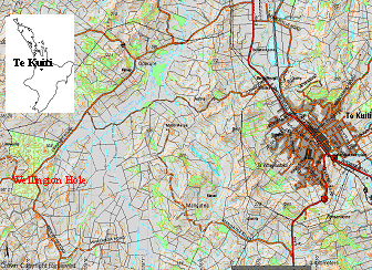 Figure 1: Location of Wellington Hole, North Island, NZ 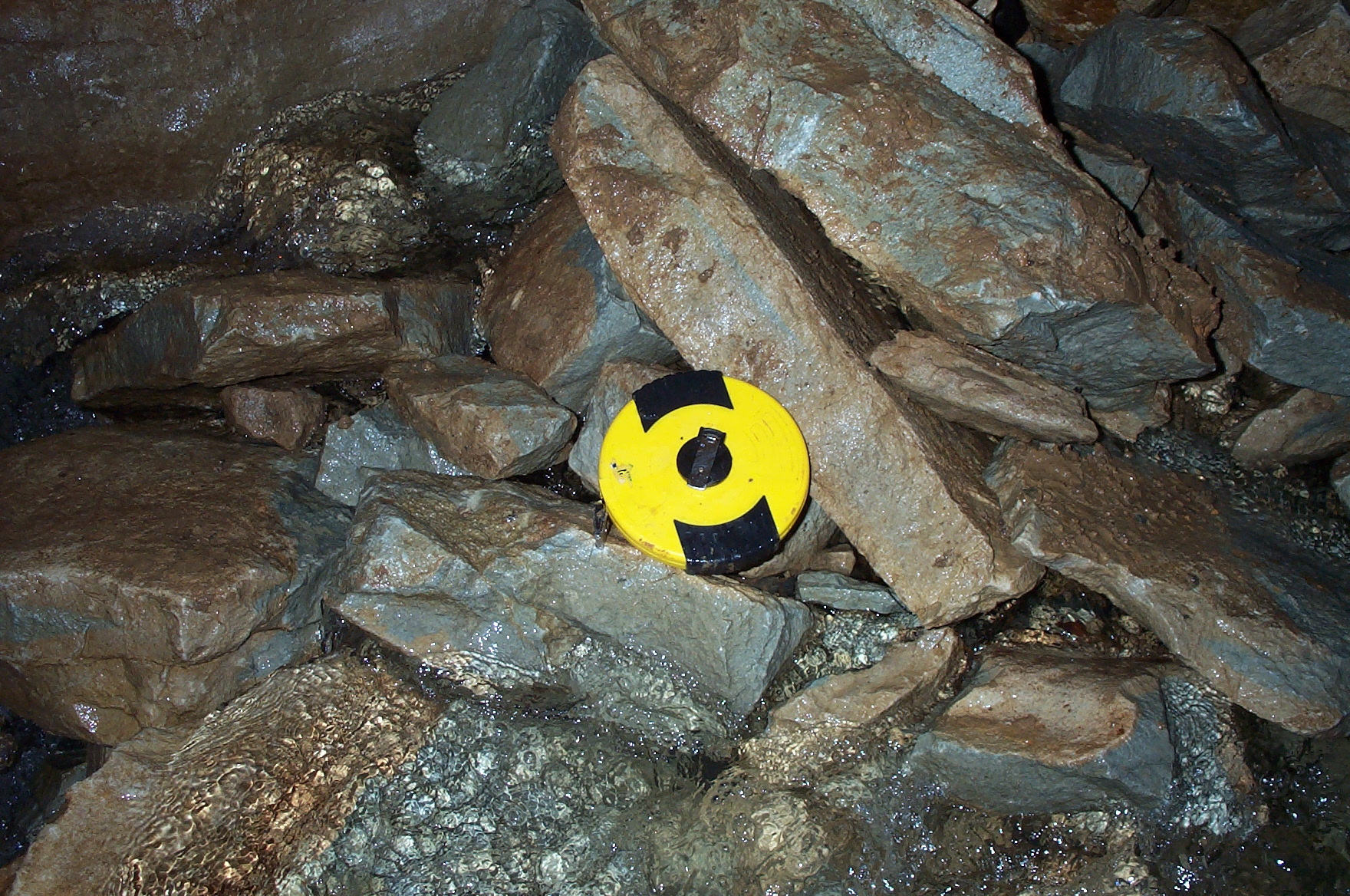 Figure 4: Limestone blocks in the stream at the entrance shaft. Tape diameter, 0.2 m |
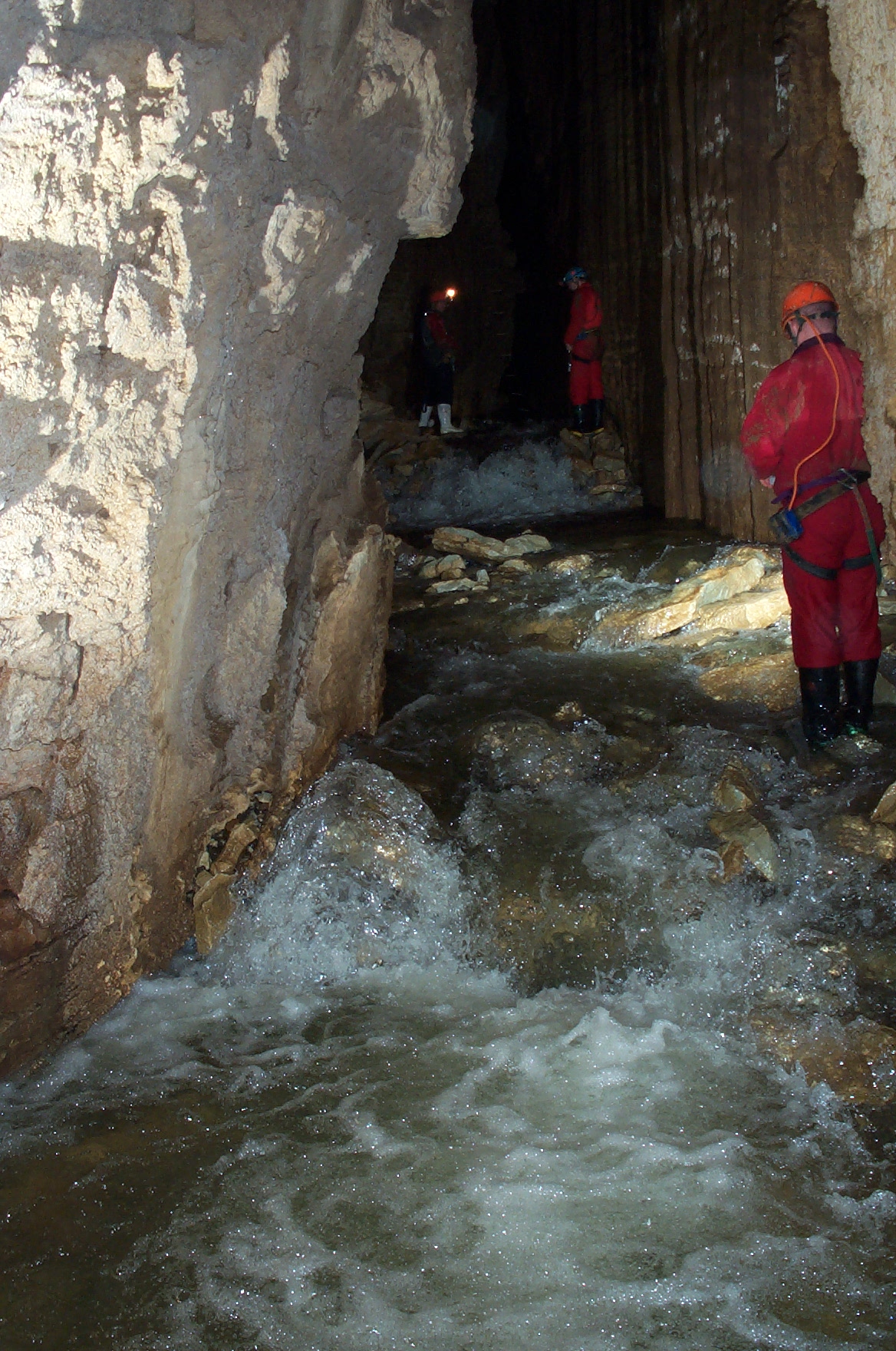 Figure 2: Limestone blocks in the cave, looking upstream to entrance shaft. Person in white gumboots is standing directly below the entrance shaft |
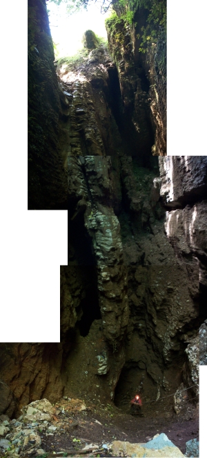 Figure 3: Composite photograph of the Wellington Hole entrance shaft |
Discussion
Process of material deposition in the cave
The limestone generally found around most doline entrances is in situ (ie, not detached by erosion). In most dolines the limestone has been gradually weathered by solution to form the characteristic 'funnel' shape. The surface materials in the entrance of doline caves in the Waitomo and Te Kuiti area is composed mainly of authigenic material (ie, not derived from the limestone). This is typically a mixture of volcanic ash and non-limestone rocks such as sandstones from the Te Kuiti stratigraphic sequence. Limestone blocks may be found in some doline entrances where weathering has led to minor entrance collapse.
The most likely natural processes that could supply the large volume of fresh limestone blocks observed at the bottom of the entrance shaft in Wellington Hole are mechanical weathering processes such as freeze-thaw weathering. However, freeze-thaw weathering is a minor process in the Te Kuiti district and would not lead to such massive detachment of limestone blocks as seen in Wellington Hole. The extensive fresh weathering faces on the limestone blocks indicates they were recently detached from a rock mass by artificial means.
The surficial geological unit in the Te Kuiti and Otorohanga districts is volcanic ash from eruption of the Hamilton volcanoes. The piles of detached limestone blocks in the car park next to the Wellington Hole doline are on top of the ash and therefore have been placed artificially.
The process of material deposition in the cave was by fall down the doline from the lip of the doline. A composite photograph supplied by Roger MacCulloch (Environment Waikato) shows this very clearly (Figure 5). In the photograph two different piles of limestone blocks are visible in the right foreground. The pile on the extreme right of the photograph does not include volcanic ash and was probably derived from a limestone face, given the mix of weathered and unweathered limestone. The pile in the centre of the photograph includes some volcanic ash and was probably bulldozed into that position. Clearly visible on the slopes of the doline below the left-hand pile are tracks where rocks have slid down the doline. Also visible on the far side of the doline are minor slip features in the ash, indicating that the ash is close to its angle of repose. The gradient of the ash slope of the doline is typical for dolines in the Te Kuiti area.
The angle of the batter in the rock pile in the left of the photograph is higher than the slope of the doline below, indicating that the pile has failed into the doline recently. There are no major slump features apparent on the lip of the doline, suggesting the rock material has been dumped into the doline, rather than slumping from the surface.
Origin and age of material deposited in the cave
The limestone material deposited in the cave stream is similar in size distribution, shape and weathering surfaces to the limestone blocks situated outside the cave. (Figures 6 and 7). The blocks in the cave clearly show the freshly weathered surfaces evident on the material at the surface (Figure 4). Freshly weathered surfaces such as this are not found on limestone blocks that have been in cave streams for more than a few months.
The limestone material in the cave is almost wholly derived from the piles of material in the car park at the surface and was recently introduced to the cave.
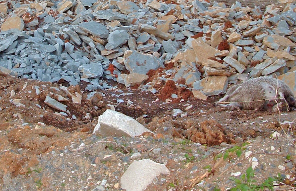 Figure 5: Limestone blocks outside the cave. Dead sheep is 1.2m long 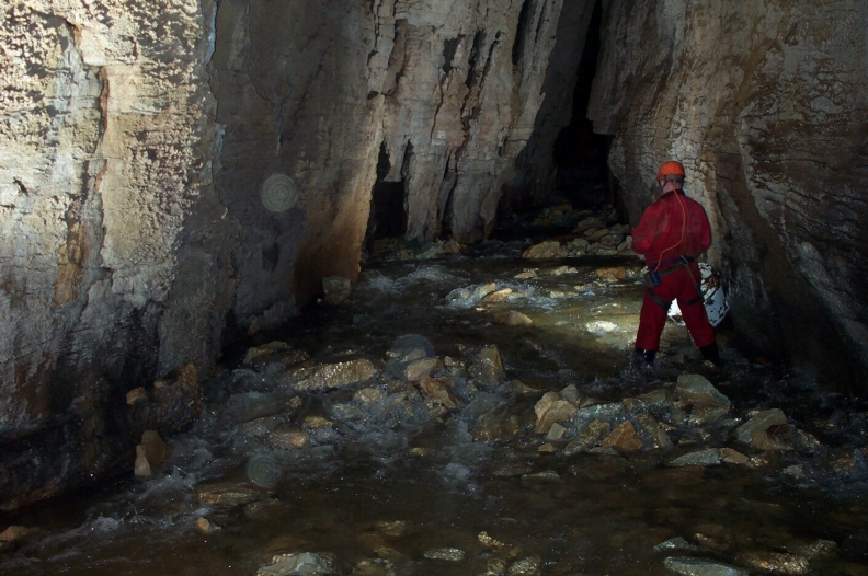 Figure 6: Limestone blocks inside the cave. Figure is 1.7m high |
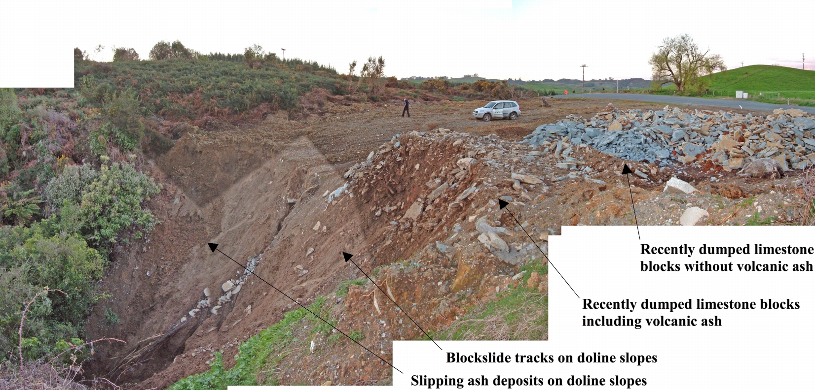 Figure 7: Composite photograph of the entrance to Wellington Hole |
Actual effects of material in the cave
The actual effects of the limestone blocks on the cave can be divided into two groups of effects.
Effects during the material deposition include:
- Destruction of vegetation on the doline slopes
- Dislodging of sediment into the cave
- Destruction of cave entrance fauna
Effects following deposition of material in the stream include:
- Damming of the cave stream with debris
- Creating a pool upstream of the debris dam and a riffle downstream
- The limestone blocks falling into the cave probably created a debris dam 8-10m high. This debris dam was unstable as soon as it formed, according to the landslide dam stability index of Ermini & Casagli (2003). The debris dam probably failed as soon as the water impounded upstream overtopped the limestone block pile. The existing form of the block pile is the relaxed form of the debris dam. It should experience further settlement and downstream movement of the blocks during high flow conditions.
Potential effects of material in the cave
The potentially experienced effects and likely future effects of the limestone blocks and gravels on the cave include:
- Destruction of fossil remains where the blocks impacted
- Further transport of limestone blocks downstream through the cave
- Reduction in fine-grained sediment flux downstream
- Impoundment of fine-grained sediment behind the debris dam, creating a 'mud pool' upstream of the debris dam
Mitigating actual and potential effects
The measures available for mitigating the actual and potential effects of the limestone blocks on the cave were:
1. Effect of debris dam on water levels and sediment impoundment:
a. Remove the limestone blocks from the cave. This option was likely to be relatively expensive, because it involved lifting a large volume of material up the non-vertical shaft.
b. Relocate the limestone blocks in the cave. This option involves removing the crest of the debris dam manually and stacking the blocks to the sides of the cave passage. This option was cheaper than option a., but will involve a significant input of skilled labour in the cave.
c. Do nothing. The crest of the debris dam will naturally be reduced in height by water passing over the debris dam, but it may take some years to reduce the height of the crest sufficiently to lower the water level to a level that is more suitable upstream.
2. Effect of limestone blocks on doline vegetation, fossils and sediment:
a. Revegetate the doline slopes. This has already been undertaken at the top of the doline.
b. Excavate any fossil remains. It is likely that few fossil remains will be found in the doline sediments in a condition suitable for excavation. This option is unlikely to be feasible.
Conclusions
The main conclusions of the investigation at Wellington Hole were:
1. The material in Wellington Hole appears to have arrived through dumping of limestone blocks at the margins of the doline, rather than natural slumping of the doline margins.
2. The limestone blocks at the bottom of the Wellington Hole shaft are very similar to the blocks at the surface, indicating they are of the same age and the material in the cave was recently dumped there.
3. The dumped material is increasing water levels upstream of the debris dam that was formed in the stream. The debris dam is also trapping fine-grained sediment. During the dumping, the limestone blocks stripped the doline slopes of vegetation and possibly destroyed fossil remains in the doline slopes.
4. The limestone blocks in the debris dam should be manually stacked to the side of the passage to lower the crest of the debris dam and water levels upstream.
References
Ermini, L. & Casagli, N., (2003) "Prediction of the behaviour of landslide dams using a geomorphological dimensionless index", Earth Surface Processes and Landforms 28, 31-47.