KARST INVENTORIES AND MANAGEMENT IN COASTAL TEMPERATE RAINFORESTS OF BRITISH COLUMBIA: TWO YEARS ON
1 Cave Management Services, 544 Springbok Road, Campbell River, BC, Canada, V9W 8A2 (pgriff@island.net)
2 Terra Firma Geoscience Services, 1480 Sherwood Drive, Nanaimo, BC, Canada,V9T (tstokes @island.net)
3 2483 Wilcox Terrace, Victoria, BC, Canada, V8Z 5R7. (b.ianson@shaw.ca)
1.0 Introduction
Significant progress has been made on karst inventory procedures and karst management issues in British Columbia (BC) since the authors' last presentation at the ACKMA Conference in Wombeyan Caves Park in 2001 (see Stokes, Griffiths and I'Anson, 2001). A revised version of the Karst Inventory Standards and Vulnerability Assessment Procedures for British Columbia (Resource Information Standards Committee, 2003), refining the procedures for conducting karst field assessments, was completed in January 2003. The Karst Management Handbook for British Columbia (BC Ministry of Forests, 2003) was completed and released in May 2003. Several new planning-level inventory projects (1:20 000 scale) have been initiated by forest companies. Lastly, a number of new karst training and potential research initiatives are underway in British Columbia. The purpose of this paper is to summarise some of these recent advances, highlight some of the principal issues involved, and provide some comments as to where future progress should be made.
2.0 Karst in BC and the Karst Inventory System
Approximately 10% of BC is underlain by carbonate bedrock, with most occurring in the Canadian Cordilleras or Rocky Mountains. However, a significant amount of carbonate bedrock and associated karst occurs along the west coast of BC (e.g., Vancouver Island and the Queen Charlotte Islands) and in the Interior (e.g. near Williams Lake and Nelson). A wide variety of karst landscapes and ecosystems occur within this carbonate bedrock, varying from shoreline karst to forested and alpine karst (see Stokes, Griffiths and I'Anson 2001). Some of the best-known cave and karst areas occur on Vancouver Island, which is the focus of much of the current karst inventory and karst management work (Stokes and Griffiths, 2000).
Considerable effort has been made in BC since 1997 to develop a systematic karst inventory system for examining and assessing karst lands. This work is presented in the Karst Inventory Standards and Vulnerability Assessment Procedures for British Columbia (Resource Information Standards Committee, 2003). BC's karst inventory system is a hierarchical scheme that starts at the broad reconnaissance level (1:250 000 scale), moving down to the more regional planning level (1:50 000 or 1:20 000 scale), and finally to the detailed karst field assessment at the operational level (1:10 000 or 1:5000 scale).
3.0 Karst Management Handbook for BC
The Karst Management Handbook for British Columbia was initiated in 1997 (concurrent with the karst inventory system), and was in response to concerns over the impacts of timber harvesting on karst terrain. In May 2003, after numerous internal and stakeholder reviews, the handbook was released for use (see http://www.for.gov.bc.ca/hfp/fordev/karst.htm)
The Karst Management Handbook recommends best management practices for integrating karst resources with the management of forest lands, within the context of British Columbia's new Forest and Range Practices Act. The Forest and Range Practices Act introduces a results-based forest practices code that relies heavily on the professional accountability of resource managers, and ultimately holds the forest industry responsible for targeted outcomes.
Best management practices are provided for both the broad karst landscape and specific karst features. While many of the recommended practices in the Handbook focus on the management of individual karst features, collectively, these practices serve to provide protection for the entire karst ecosystem.
The handbook aims to protect both significant surface and subsurface karst resources through best management practices applied to the surface karst environment. The best management practices are intended to promote sustainable forest practices on karst landscapes and achieve the following objectives:
- maintain the capability of karst landscapes to regenerate healthy and productive forests after harvesting;
- maintain the high level of biodiversity associated with karst ecosystems, including surface and subsurface habitats;
- maintain the natural flows and water quality of karst hydrological systems;
- maintain the natural rates of air exchange between the surface and subsurface;
- manage and protect significant surface karst features (e.g., sinkholes, sinking streams, springs, and cave entrances) and subsurface karst resources (e.g., caves, underground streams, and subterranean fauna);
- provide recreational opportunities where appropriate; and
- minimise impacts to timber supply and operational costs.
The handbook is to be used in conjunction with the findings and recommendations of a karst field assessment, which evaluates the karst attributes in and around a proposed cutblock and/or access road. These types of field assessments are recommended prior to the initiation of road construction or timber harvesting on karst terrain.
The handbook recommends reserves for the following significant karst features:
- Significant Cave Entrances;
- Above Significant Caves;
- Significant Surface Karst Features;
- Significant Karst Springs;
- Unique or Unusual Karst Flora/Fauna/Habitats
The significance of karst features is determined during a karst field assessment. Significant karst features are considered to have higher values requiring additional protective measures during forest management, as determined by a qualitative evaluation of a number of criteria, including:
- Dimensional characteristics
- Connectivity between surface and subsurface
- Hydrological characteristics
- Geological values
- Biological values
- Scientific and educational values
- Archaeological, cultural and historical values
- Recreational and commercial values
- Rarity and abundance
- Visual quality
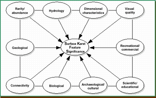
Where the significance of a karst feature is unknown, or has yet to be determined, the handbook recommends that the feature be treated as significant.
Reserves for significant karst features can often be combined with management objectives for the retention silvicultural system, old-growth management areas, wildlife tree retention, riparian management areas, or wildlife habitat areas to help meet the needs of overlapping forest resources.
Riparian management recommendations in the Karst Management Handbook focus on watercourses that sink or lose water to the subsurface, as they have the potential to transport sediment and debris into sensitive subsurface karst environments. Recommended practices are based on stream width and the significance of the recipient karst feature.
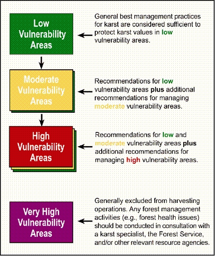
The broader karst landscape is managed using best management practices that are linked to the assessed vulnerability of the karst. As the level of karst vulnerability increases, so do the protective measures of the best management practices.
Best management practices are provided for harvesting operations on low, moderate, and high vulnerability karst areas. The handbook recommends that very high vulnerability areas be excluded from harvesting operations in most cases. Limited exceptions to this may occur in special situations where some form of site-specific intervention is required to help protect forest or karst resources (e.g. forest health issues such as insect infestations). Best management practices are recommended for:
- Locating roads, landings and quarries;
- Road, landing and quarry construction, maintenance, deactivation and rehabilitation;
- Timber harvesting; and
- Post-harvest operations
The Karst Management Handbook also addresses management issues in the non-karst portion of a karst catchment. Recommended practices focus on managing streams that sink or lose water into downstream karst units that contain significant karst resources vulnerable to inputs of sediment and debris, temperature fluctuations, or changes to flow characteristics. On-line training for the Karst Management Handbook is now available at: http://www.for.gov.bc.ca/hfp/fordev/karst.htm. Beginning in the fall of 2003, "tailgate" training sessions will be delivered to forest practitioners at selected locations throughout British Columbia.
4.0 Refinements to the Karst Field Assessment Procedure
During 2002/2003, the procedures for conducting karst field assessments in British Columbia were streamlined and refined based on operational experience and user feedback. Revisions were made to a number of field procedures, including surface mapping, determining karst field assessment boundaries, delineating karst polygons, evaluating streams and catchments, and determining subsurface karst potential. The revised Karst Inventory Standards and Vulnerability Assessment Procedures for British Columbia can be viewed at: http://www.for.gov.bc.ca/hfp/fordev/karst.htm).
A two-day training course on conducting karst field assessments was also completed during 2003. The course provides one day of classroom instruction and one day of practical field experience to qualify participants to conduct these specialised karst inventories.
5.0 Application of Planning-level Inventories on Forested Karst Lands
Two planning-level karst inventory projects are currently near completion for two forest companies on North Vancouver Island. Each project area covers approximately 200 000 hectares. Prior to the fieldwork, GIS mapping techniques were used to combine the various sources of geological information on karst, unit boundaries and to provide a preliminary analysis of karst vulnerability potential. The karst vulnerability potential analysis was based on a simple algorithm model using slope gradient and elevation, with gentler and higher elevation slopes giving higher karst vulnerability potential estimates.
Fieldwork for the planning-level projects focused on delineating the karst unit boundaries, recording karst attributes to estimate karst vulnerability potential, and identifying and locating any potentially significant surface karst features. A standardised system for recording field data was developed to maintain consistency between different field workers.
As part of both projects, a modeling procedure was developed to determine the likely karst net downs for timber supply analyses (i.e. the amount of forested area removed from the timber harvesting land base to protect or manage significant karst features). The model utilised the planning-level karst inventory attributes and attempted to predict the number of specific 'karst net down features' likely to occur within a karst polygon, independent of the karst polygon's vulnerability potential rating. The number of karst net down features for any particularly polygon was then converted to an equivalent reserve area (i.e. net down area) as recommended by the Karst Management Handbook.
Additional planning-level karst inventories are likely to be completed over the next few years, with small projects in the Southeast Interior of BC and on the west coast of Vancouver Island.
6.0 Future Directions for Karst Management in BC
Karst management in BC has come a long way in the last six years. However, relatively little is known or understood about the processes of forested karst systems. One important study (Harding and Ford, 1993) investigated the effects of logging on limestone slopes on Northern Vancouver Island. A follow-up to this study could shed much needed light on the processes associated with forest regeneration on harvested karst sites.
Further education and training in karst issues, monitoring of forest activities on karst landscapes, and research into karst processes are strongly recommended to facilitate effective karst management in BC. Current training initiatives include an online training course and one-day tailgate session on the Karst Management Handbook, as well as a two-day course on conducting karst field assessments.
Academic research is being carried out independently by a number of researchers with universities and government agencies, including palaeontological/archaeological investigations in caves on the Queen Charlotte Islands, global climate studies on cave speleothems, and cave sediment studies. Ongoing research is also being carried out on bats and karst-related flora.
Further research is required on a number of specific issues related to karst management, including:
- mechanisms of sediment transport in sinking/losing streams, and the impact on subsurface environments
- the movement of soil and soil loss after harvesting on high vulnerability karst surfaces
- the optimum size of reserves and management areas around significant features
- the maintenance of water quality/quantity and implications for autogenic and allogenic recharge on karst areas
Two further refinements to the current BC karst inventory system should also be considered. These include revising BC's existing cave inventory and classification procedures to make them more compatible with the surface karst inventory system (see BC Ministry of Forests, 1994), and updating the reconnaissance-level karst potential mapping (1:250 000 scale). Since the reconnaissance-level karst potential maps were completed in 1999, the digital bedrock mapping for BC has been extensively revised, and numerous data errors and inconsistencies have been removed. These changes should be incorporated into the reconnaissance-level karst maps, along with efforts to create a more user-friendly product, possibly using interactive web software such as that currently used by BC Map Place (see http://www.em.gov.bc.ca/Mining/Geolsurv/MapPlace/default.htm).
Some limited karst management monitoring is being implemented by at least one forest company to assess the impact of harvesting on the subsurface karst environment. However, it is highly recommended that post-harvest assessments of road construction and timber harvesting on karst terrain be carried out on a routine basis to provide useful feedback for refining inventory procedures and best management practices for harvesting operations.
Another useful initiative would be for local universities/colleges to introduce courses or workshops focusing on understanding the science of karst systems and processes. This would be of interest to students from a variety of scientific disciplines. Developing some form of centralised 'Karst Studies Centre' for research and instruction may also be a worthwhile consideration for the future.
7.0 Conclusion
British Columbia is making significant strides towards responsible management of its considerable karst resources. Over the last few years in particular, karst management issues have increasingly gained recognition within both government agencies and the forest industry. Future efforts need to focus on continuing education and extension, as well as dedicated research and monitoring. Information sharing with other jurisdictions with similar forested karst characteristics would also serve to further refine and improve BC's approach to karst management.
REFERENCES
BC Ministry of Forests. 1994. Cave/Karst Management Handbook for the Vancouver Forest Region. BC Ministry of Forests, Victoria, BC.
Harding, K.A. and D.C. Ford. 1993. Impacts of Primary Deforestation upon Limestone Slopes in Northern Vancouver Islands, British Columbia. Environmental Geology 21:137-143.
Resources Inventory Standards Committee (RISC). 2003. Karst Inventory Standards and Vulnerability Assessment Procedures for British Columbia. Victoria, BC. http://www.for.gov.bc.ca/hfp/fordev/karst.htm
Stokes, T.R., P. Griffiths, and B. I'Anson 2001. Karst Inventory Standards and Vulnerability Assessment Procedures for British Columbia: A Canadian Approach to Managing Forested Karst Lands. Proceedings of 14th Australasian Conference on Cave and Karst Management, Wombeyan Caves, New South Wales.
Stokes, T.R and P. Griffiths. 2000. A Preliminary Discussion of Karst Inventory Systems and Principles (KISP) for British Columbia. BC Ministry of Forests, Research Branch, Victoria, BC. Working Paper 51/2000. http://www.for.gov.bc.ca/hfp/fordev/karst.htm
Stokes, T.R., T. Aley, and P. Griffiths. 1998. Dye Tracing in Forested Karst Terrain: A Case Study on Vancouver Island, British Columbia. in Post-conference Proceedings of the 8th International Association of Geological Engineers, Vancouver, BC. (see Appendix of Stokes and Griffiths, 2000).