Karst Inventory Standards and Vulnerability Assessment Procedures for British Columbia: a Canadian Approach to Managing Forested Karst Lands
Introduction
The aim of this paper is to familiarise the reader with a set of karst inventory standards and vulnerability assessment procedures that have recently been developed for British Columbia, Canada (Resource Inventory Committee, 2001). The purpose of these standards and procedures is to provide a systematic methodology for evaluating karst landscapes and ecosystems so they can be effectively managed across the province. Funding for the development of karst inventory standards and vulnerability assessment procedures has been provided by both the BC Ministry of Forests (Research Branch) and Forest Renewal BC.
Methodologies for completing karst inventories were developed at three levels:
- the reconnaissance level inventory (1:250 000 map scale);
- the planning level inventory (1:20 000 or 1:50000 map scales); and
- the karst field assessment (1:5000 or 1:10 000 map scales).
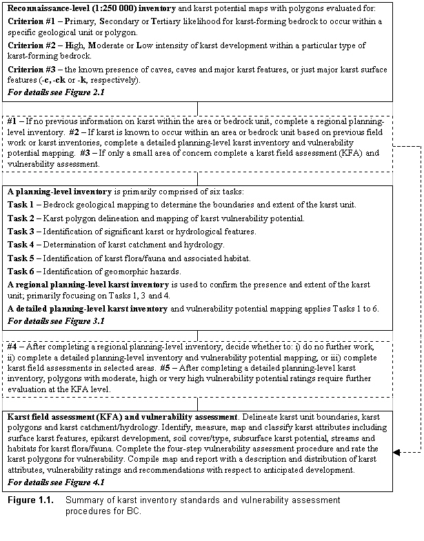
These three levels of inventory provide a filtered approach to karst evaluation – starting at the reconnaissance level and moving progressively downward through an intermediate planning level to the karst field assessment (KFA). Each level has an increasing requirement for data collection and field evaluation. Karst vulnerability assessment procedures are applied at both the planning and KFA levels where the karst landscape is stratified into polygons of similar karst vulnerability 1.
At the planning level, karst mapping is carried out and polygons are rated for karst vulnerability potential2. These polygons highlight the most likely karst vulnerability ratings (low, moderate, high or very high) to occur within a particular polygon. At the KFA level, detailed karst vulnerability evaluations are carried out using a rigorous four-step procedure. The three karst inventory levels and vulnerability rating procedures are summarised in Figure 1.
The primary users for the karst inventory standards and vulnerability assessment procedures are anticipated to be forest operators and associated government agencies, such as the BC Ministry of Forests. The standards and procedures are closely linked with the Karst Management Handbook for British Columbia (BC Ministry of Forests, in preparation), which outlines best management practices for forestry activities on karst landscapes. The karst inventory standards and procedures are also intended for other land users, such as mining companies (developing quarries or roads), municipal or industrial developments on karst, and recreational park agencies. Further details on the linkages to karst management are outlined in the last section of this paper.
Karst Ecosystems in British Columbia
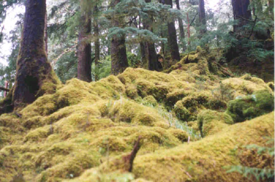
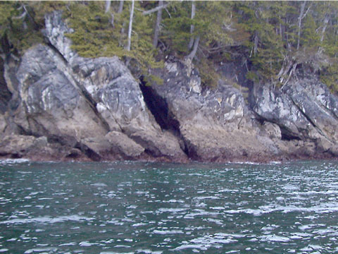
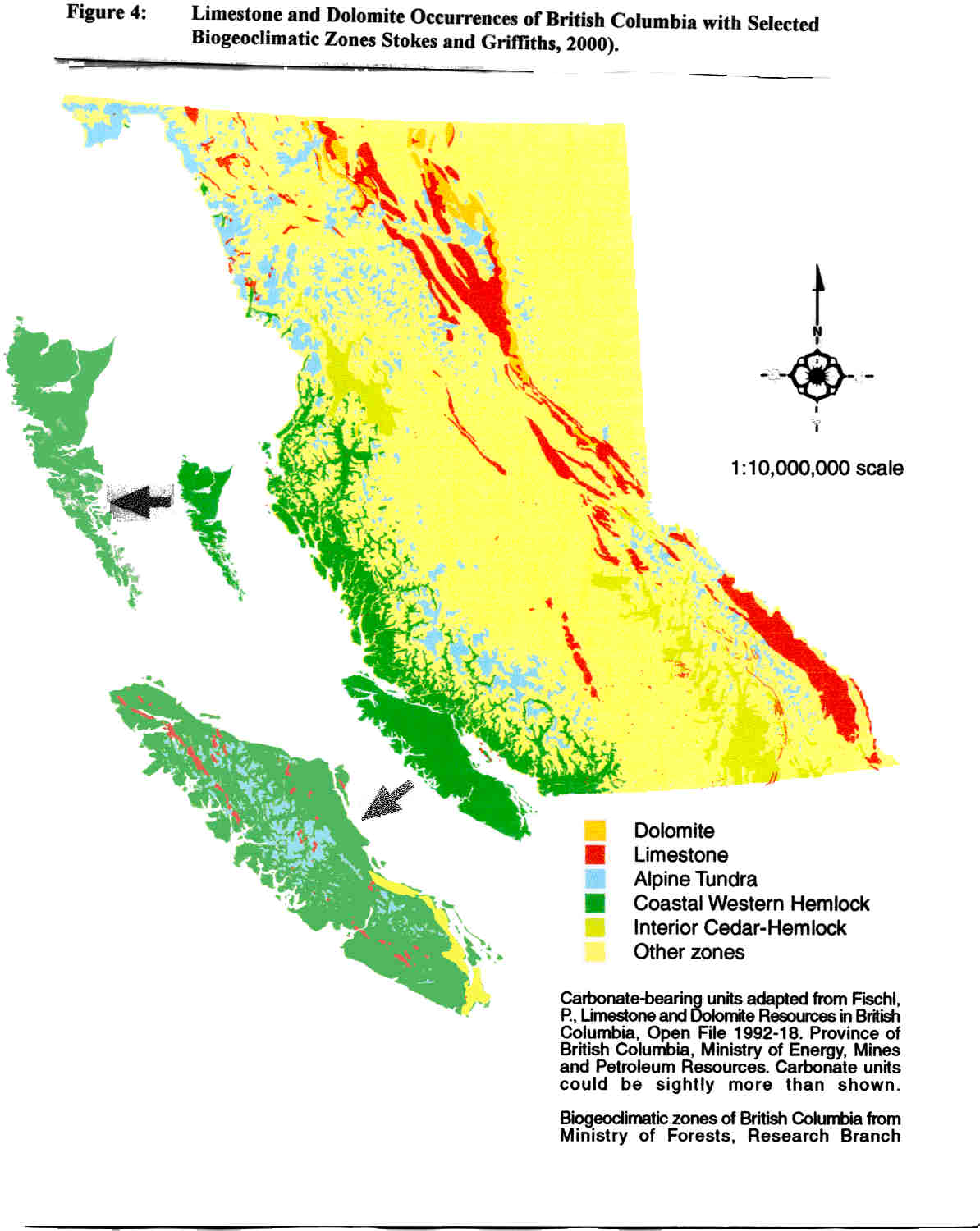
BC is located on the western coast of Canada, and is about 950,000 km2 in size. Approximately 10% of BC is underlain by bedrock units that contain carbonate material - primarily limestone with lesser amounts of dolomite and marble. (Minor gypsum karst is also present.) To date, karst is known to occur in the Rocky Mountains, along the Pacific Coast (e.g. Vancouver Island, Queen Charlotte Islands and North Coast), and in the Interior plateaus and mountain ranges. A wide range of karst landscapes are present in BC from: shoreline, lowlands, valley bottoms, mid and upper forested slopes, plateaus and alpine (see Figure 2). A potentially diverse array of karst ecosystems likely occurs in BC, as carbonate bedrock is found in most of the 14 broad biogeoclimatic zones of the province (see Figure 3). These biogeoclimatic zones are part of the Ecosystem Classification of BC (BC Ministry of Forests, 1992) and are based on climate setting and dominant tree species (e.g. coastal western hemlock, interior cedar-hemlock, mountain hemlock, montane spruce, bunch grass, alpine tundra zones). Most of the best known forested karst occurs along the west coast of BC (primarily Vancouver Island) and is within the coastal western hemlock zone. This forested karst is similar to that found in the temperate rainforests of Tasmania, New Zealand and Chile. The BC coast has been the focus of much of the karst inventory and karst management work to date, and includes some of the most productive old and second growth forests in BC. Karst ecosystems in the coastal western hemlock zone are characterized by abundant rainfall, mild temperatures, large trees (e.g. western hemlock, amabilis fir, western red cedar and Sitka spruce), thick understorey, mature soils of glacial and organic origin, and well-developed surface karst features, epikarst and caves.
Figure 1. Summary of karst inventory standards and vulnerability assessment procedures for BC. (Taken from Figure 1.1, Resources Inventory Committee. 2001)
Karst has been known for many years in the alpine tundra of the Rocky Mountains (Ford, 1979), where extensive belts of limestone and dolomite extend for 100's of kilometres. These karst areas are typically characterised by thin to no soil cover, well-developed epikarst exposures, distinct karst flora associations and deep cave systems. One of the most well-known cave systems, Castleguard Cave, is developed under the Columbia Icefield, and straddles the Southern BC and Alberta border. Alpine karst areas also occur on Vancouver Island, such as White Ridge (Ecock, 1984); however, detailed information on these karst areas as functioning ecosystems is limited.
The knowledge of karst ecosystems in the Interior of BC is less than either of the two regions above. In the Southern Interior, two of the most well known karst areas occur at Cody Caves Provincial Park (near Nelson) and Nakimu Caves in Glacier National Park. Both these karst areas occur as steep, narrow bands of limestone. Cody Caves is within the interior cedar-hemlock biogeoclimatic zone, with only minor epikarst development, occasional surface karst features and relatively shallow cave systems. Karst also occurs in the Central Interior (e.g. near Williams Lake and Chetwynd) in the foothills of the Rockies. These karst areas are typically covered with thick glacial soils, with little to no solutional epikarst development, but some isolated and occasionally large surface karst features. Some of the least explored, but possibly most spectacular karst, occurs in the relatively inaccessible northwestern part of BC, such as along the Stikine, Taku and Nakina Rivers. Large karst canyons and gorges are reported in these areas.
Figure 2. Examples photographs of karst ecosystems/landscapes in British Columbia. (1) Coastal forested karst, Queen Charlotte Islands. (2) Alpine karst, Queen Charlotte Islands. (3) Shoreline karst, North Coast BC. (4) Interior karst, Chetwyndd Region, North-Central BC.
 1. 2.
1. 2. 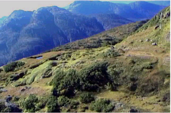
 3. 4.
3. 4. 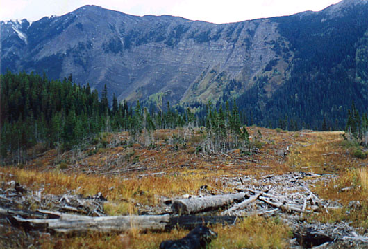
Reconnaissance Level Karst Inventory
Reconnaissance level karst inventory work for the entire province was completed in 1999, and includes a set of 84 map sheets (1:250 000 scale) outlining carbonate bedrock with differing potential for karst development (Stokes, 1999). These maps are available in Arc-Info format from the BC Ministry of Forests and can be readily incorporated into any GIS system. The maps provide boundaries for karst potential polygons and are linked to a database with karst attribute and rating information. The purpose of the reconnaissance karst potential3 maps is to flag areas of likely karst development, so as to direct further inventories and assist in higher level strategic planning. This reconnaissance level karst inventory work was an office-based exercise that included an analysis of 1:250,000 scale bedrock g ology maps (available from the BC Geological Survey and the Geological Survey of Canada), and a compilation of the main known cave and karst occurrences in British Columbia.
During the reconnaissance level inventory, approximately 7,568 polygons were examined and rated for three criteria. Two criteria were used to evaluate karst potential within a particular bedrock unit or polygon, while a third was used to allocate known cave/karst information. Criterion #1, the likelihood of karst forming or soluble bedrock (e.g., limestone, dolomite, marble or gypsum) to occur within a unit (or map polygon), was evaluated by estimating the proportion of soluble bedrock present and rating it as one of three categories – Primary (P) >50%, Secondary (S) 20-49%, or Tertiary (T) 5-19%. Criterion #2, the intensity of karst development in a particular type of soluble bedrock, was determined for each map polygon using four attributes considered to be among the primary controlling factors for karst development – chemical purity, bedrock lithology, topographic position, and unit thickness/continuity. These factors were estimated, categorized and placed into a numerical algorithm, qualitatively ranking each polygon as low (L), moderate (M) or high (H) for likely intensity of karst development. Criterion #3, the known occurrence of caves or major surface karst features, was initially included on the karst potential maps. However, subsequent work (Stokes and Griffiths, 2000) suggested that separation of this data from the karst potential maps is probably more useful, as it allows the user to independently assess the relative significance of a known cave/karst feature within a polygon.
Figure 3. Limestone and dolomite occurrences (and by inference potential karst ecosystems) in British Columbia along with selected biogeoclimatic zones. (Taken from Figure 3, Stokes and Griffiths, 2000).
The reconnaissance level karst potential maps have the following limitations:
- the 1:250,000 scale polygon boundaries are generally not reliable at more detailed scales;
- the Criteria #1 and #2 ratings are somewhat unreliable in areas not field verified for karst;
- significant inconsistencies occur in the original bedrock data; and
- only limited cave/karst information was gathered.
Despite these limitations, the reconnaissance karst potential maps can be considered a good starting point for determining the needs for planning level inventories or KFAs. Field work or prior knowledge of karst conditions at a site is crucial. Once the general karst conditions are known at one site, it is possible, with some care, to predict the likely karst conditions for adjacent polygons within the same soluble bedrock unit. In conclusion, the reconnaissance karst potential mapping should not be considered as the final product, but rather as a starting point to which additional information can be added over time (Stokes, 1999).
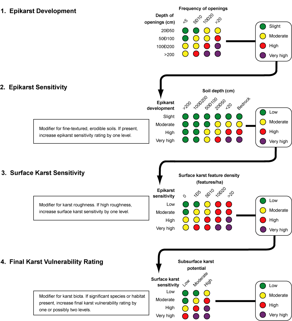
Figure 4. Four-step vulnerability assessment procedure used at the KFA level. (Taken from Figure 4.14, Resources Inventory Committee. 2001
Planning Level Karst Inventories
The primary goals of the planning level karst inventory are to obtain a general sense of the karst attributes at the landscape level, assist forest development planning, and identify areas for more detailed KFAs. Six major field tasks are associated with a planning level inventory:
- Task 1 Bedrock geological mapping to delineate the geological contacts of the karst unit and its three dimensional distribution
- Task 2 Karst vulnerability mapping to define karst polygons and map the variation in karst development
- Task 3 Identification of significant surface karst features (including major cave entrances), large well-developed epikarst exposures, streams and hydrological features
- Task 4 Delineation of the karst catchment to determine its regional extent4
- Task 5 Identification of unique or unusual karst flora and fauna, and/or associated habitats
- Task 6 Identification of any geomorphic hazards that could impact a karst unit (e.g., a landslide)
There are two types of planning level inventory: a 'regional planning level inventory' and a 'detailed planning level inventory'. The primary aim of the regional planning level inventory is to broadly evaluate the likely presence and/or extent of karst within an area (primarily Tasks 1, 3 and 4), and is carried out where little or no prior knowledge of karst is present. A detailed planning level inventory evaluates areas of karst that are either known or anticipated from adjacent areas, using the same tasks for the regional planning level inventory, but also includes stratification of the karst landscape into polygons of different vulnerability potential (Task 2). Tasks 5 and 6 can be carried out during both types of inventory, but are usually minor components.
As a first step in competing a regional or detailed planning level inventory, all available information for the area of interest is collected and compiled, including detailed bedrock geology maps, surficial geology maps, detailed topographic information, airphotos and any other relevant mapping information or reports. All relevant karst information (e.g., unit boundaries, known features) is transferred onto a base map (1:20,000 or 1:50,000 scale) and is then available for field work.
Bedrock mapping in an integral and fundamental part of the planning level karst inventory procedure. Considerable geological field work is required where complex geological relationships are encountered, or where detailed bedrock mapping is unavailable. In general, bedrock mapping should include: delineating the karst unit boundaries, the bedrock lithologies, the types of geological contacts, and the main bedrock faults and fold structures. Sufficient bedrock information should be obtained so that the surface and likely subsurface extent of the main karst forming unit can be determined.
Karst mapping and vulnerability potential evaluation are major field tasks of a detailed planning level inventory. For any particular site, these tasks involve the delineation of karst polygons, the analysis of karst attribute data, and rating of polygons for karst vulnerability potential. Many of the procedures and standards used for karst mapping are similar to those for terrain mapping in BC (Resource Inventory Committee, 1996; Howes and Kenk, 1988). However, the fundamental concepts of karst mapping are based more on the distribution and variations of karst attributes rather than terrain attributes. The vulnerability potential rating of karst polygons is a qualitative evaluation of the karst and terrain characteristics, in particular, epikarst development, density of surface karst features, subsurface karst potential, soil thickness, bedrock lithology and slope gradient. Four rating categories of vulnerability potential are used - low (L), moderate (M), high (H) and very high (V).
Karst Field Assessments (KFAs)
KFAs are detailed inventories at the site level, and in the case of forest development occur where timber harvesting units or access roads are proposed in karst terrain. The prime goals of the KFAs are to accurately map the boundaries of the karst unit, identify and evaluate specific surface karst features, assess streams crossing karst, and stratify the karst landscape into polygons of similar characteristics. Subsurface inspections of caves are carried out during the KFA to map their extent and assess their significance.
The major karst attributes evaluated during a KFA include:
- karst unit boundaries and main characteristics of the karst bedrock (e.g., type, proportion and bedding orientations);
- level of epikarst development and the overlying soil thickness/texture;
- density of negative relief features (e.g. sinkholes);
- location and significance of any major surface karst features;
- roughness of the overall karst surface;
- presence of caves;
- occurrence of unique or unusual karst biota and/or habitats; and
- presence of potential geomorphic hazards that could impact the karst unit.
The first critical part of a KFA is to determine the limits of the inventory, which could extend beyond the specific karst area of interest, and is dependent on the boundaries of the karst unit, the extent of the karst catchment and the known extent of any subsurface openings or caves. Ground searching and surface mapping techniques are then used to locate specific karst features and evaluate karst attributes. Stream evaluations can be carried out at the same time or as a separate procedure to determine stream type (e.g. sinking, gaining, losing), the location of sink points, and the significance of recipient features (e.g. a swallet). An important part of the KFA is to evaluate surface karst features for their significance, as these features likely require special management prescriptions (e.g. buffer zones). The significance evaluation is a qualitative procedure, and considers criteria such as dimensions, abundance/rarity, biological importance, scientific values, connectivity with the subsurface, hydrology, recreational appeal, and cultural value.
A critical part of a KFA is to stratify the karst landscape into polygons of similar karst characteristics. A number of techniques can be used for this, depending on the level of previous field work at the site. As a first step, slope gradient can be used to establish preliminary polygons. Epikarst development and the density of surface karst features can then be used to refine the polygon boundaries. Once the polygon boundaries have been delineated, each polygon is assessed and rated for vulnerability.
The four step vulnerability assessment procedure assesses epikarst sensitivity, surface karst sensitivity, and subsurface karst potential to determine a final vulnerability rating for the total karst system within a polygon (see Figure 4). Three modifying factors - fine textured, erodible soils; karst roughness; and unique or unusual karst biota and/or habitats are also integrated into the procedure.
As an example, karst landscapes with a low vulnerability typically have little exposed epikarst, few to no surface karst features and thick soil cover. Moderate vulnerability karst landscape might have moderately well developed epikarst, a thin soil veneer, a small number of surface karst features and be located so as to have a reasonable likelihood for subsurface openings. Karst landscapes with a high vulnerability have well-developed epikarst exposures, a high density of surface karst features, and known subsurface openings and caves.
Karst Inventories and Karst Management
The management of karst terrain is difficult, if not impossible, without basic inventory data. Karst management should be based on a sound understanding of the karst system and processes, taking into careful consideration the best available surface and subsurface information.
Although the reconnaissance level karst potential mapping has some significant limitations, it does provide a first step in identifying where karst might occur and how well it might be developed. This information can be used for higher level strategic planning and land-use projects, as well as identifying sites for further karst inventory work.
The planning level inventory and vulnerability potential mapping are ideally suited to watershed-type studies and provide a first pass karst inventory that is supported by some level of field checking. Forest companies can use this information to assist with timber supply calculations, where karst areas with very high vulnerability potential ratings would likely result in exclusion from harvesting. This type of information is particularly important for forest development planning, where proposed sites for harvest units and roads are being considered. Avoiding areas of higher vulnerability potential could provide cost savings associated with further inventory work and the additional requirements of specialised road construction or timber harvesting techniques. Planning level mapping can directly assist KFAs by providing a starting point for background information and preliminary karst polygons. In addition, this level of mapping provides a means by which all existing karst inventory information for a region can be systematically collated and compiled. If done in digital format, this mapping can then be updated and refined as more information becomes available. The planning level inventory might also be useful for park management, providing a tool by which the karst landscape can be effectively managed as a recreational resource by identifying sites for differing levels of uses (e.g., trails, campgrounds)
KFAs examine karst terrain at the site level and collect inventory data to assist in the development of specific karst management prescription. Using KFA data, prescriptions can be developed based on the type and significance of surface karst features, the proximity of the development area to a cave system, the types and size of streams, and the vulnerability ratings of the karst polygons. The Karst Management Handbook for British Columbia (BC Ministry of Forests, in preparation) is designed to assist in the development of these prescriptions. A KFA can also be used for site-specific evaluations during mining activities, such as the development of a limestone quarry or an access road to a mine site. Other uses could be for urban development, such as a proposed landfill or industrial site. A KFA could also be applied in more unusual activities on karst terrain, such as locations for film settings or palaeontological/archaeological investigations.
Notes
- Karst vulnerability is defined as 'the susceptibility of a karst ecosystem to change, and is considered to be a function of its inherent characteristics and sensitivity'.
- Karst vulnerability potential is defined as the likelihood for a particular vulnerability rating to occur within a specific planning level polygon (e.g. a planning level polygon with moderate vulnerability potential would likely include predominately moderate vulnerability areas with lesser amounts of low and high.
- The concept of 'karst potential' provides an indication of where karst might occur and what level of karst development might be anticipated.
- A karst catchment differs from a topographic catchment in that it can include cross-divide connections through subsurface drainage paths.
References
BC Ministry of Forests. 1992. Biogeoclimatic Zones of British Columbia. Colour map published by BC Ministry of Forests.
BC Ministry of Forests. Karst Management Handbook for British Columbia. (In preparation).
Ecock, B.A. 1984. The hydrology of an alpine karst: White Ridge, Vancouver Island. Unpublished MSc thesis. MacMaster University, Hamilton, Ontario.
Ford, D.C. 1979. A review of alpine karst in the southern Rocky Mountains of Canada. National Speleological Society of America Bulletin 41: 53-66.
Howes, D.E. and Kenk, E. 1988. BC terrain classification system. BC Ministry of Environment, Lands and Parks, Victoria, BC.
Resources Inventory Committee. 2001. Karst inventory standards and vulnerability assessment procedures for British Columbia. Resources Inventory Committee. Victoria, BC
Resource Inventory Committee. 1996. Guidelines and standards for terrain mapping in British Columbia, Resource Inventory Committee, Victoria, BC.
Stokes, T. and Griffiths, P. 2000. A preliminary discussion of karst inventory systems and principles (KISP) for British Columbia. BC Ministry of Forest Working Paper 51/2000.