RECENT DEVELOPMENTS IN CAVE MANAGEMENT IN THE LEEUWIN NATURALISTE NATIONAL PARK
"CLAP - Worth a round of applause"
Abstract
A brief overview of the history of cave use in the Leeuwin–Naturaliste National Park, and the "Cave and Abseil Permit System" which was introduced in 1992 is followed by a review of changes to the operation of the Permit System. The most recent is the introduction of CALM's Cave Leader Course. The course focuses on minimal impact caving, group leadership, and safety. Since the introduction of the course there has been a significant reduction in the number of people able to book cave permits. A decrease in both visitor impacts and cave accidents could also be expected.
INTRODUCTION
Background
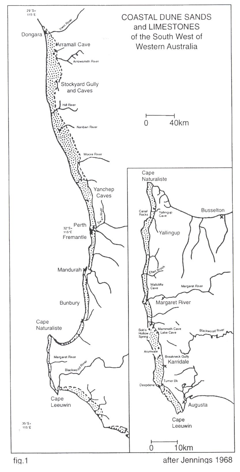
The Leeuwin–Naturaliste Ridge in the extreme SW of Western Australia, is a band of aeolian calcarenite deposited over Precambrian granitic gneiss. The aeolian calcarenite is weakly consolidated limestone, which typically has a caprock layer at the surface. It is characterised by numerous solution pipes, which may intersect caves, extensive calcite speleothem development, and caves, which often show extensive collapse. (Jennings, 1968)
The area of limestone is about 120km in length, up to 8km wide, and is up to 150m deep. In the southern half of the ridge, where the limestone is wider and deeper, nearly all of the limestone is covered by native forest, mainly National Park. However, there are extensive areas of privately owned land in the northern half of the ridge. CALM is the land manager for the larger part of the karst area. See Figure 1.
Threats
A large part of the karst of the L-N Ridge and its catchment (though this has not been precisely defined) is situated below native forest and coastal heath. Consequently, the karst does not suffer the major impacts found in many karst areas. However increasing development, both agricultural and urban may impact the karst. The most significant threat has been that of visitor impacts.
Logging was very active in the late 19th and early to mid 20th centuries, particularly in the Boranup Forest area. Agricultural practices, mainly in some of the northern areas, and effluent disposal in areas of coastal urban development are potential threats. More recently, lime sand mining has emerged as another potential threat.
The largest problem is that of human visitation to the caves. The Leeuwin–Naturaliste National Park is a three hour drive from Perth, which makes it very accessible. The region is extremely popular for many reasons - beaches, surfing, walking, wineries, forest, fine food, arts and crafts etc. From the 1960's on, there has been an increasing number of people exploring the caves of the L-N Ridge. Cavers, school groups, scouts, "Adventure" companies, surfers when there is no surf, and locals, have all added to the numbers.
The most obvious visitor impacts are damage to speleothems; erosion around cave entrances and at cliff tops; erosion and sediment movement within caves; and damage to animal habitats. Erosion and breakdown of the limestone is a particularly severe problem in these caves due to the softness of the rock. Erosion of soil cones and sandy areas is also of concern. Between 1977 when Giants Cave was surveyed, and 1993 when a ladder was installed to bypass the rockpile, 53 cubic metres of soil had been removed from the rockpile - all by foot traffic! (Bell, P. & Wood, P. pers comm.)
Leeuwin–Naturaliste National Park Management Plan 1989–1999
This management plan recognised caves as an area requiring management initiatives. Amongst the main recommendations were:
Action 6.1: Establish a Cave Management Committee jointly with CALM, Speleological Groups and other appropriate bodies to oversee cave management.
Action 6.2: Implement a permit system for visitors to wild caves.
CMAC
The Caves Management Advisory Committee first met in October 1989 and continues to meet approximately six times per year. CMAC has been and continues to be a very successful and productive advisory group. CMAC has contributed to the development of the "Cave and Abseil Permit System", and the formation of the Cave Leadership Assessment Panel, as well as many other initiatives. Initially CMAC was composed of representatives of Dept of CALM, Tourism Association and ASF affiliated caving groups. It was expanded to include representatives of the main user groups - commercial operators, schools, scouts and the Defense Dept.
Permit System
Under the permit system, which was introduced in 1992, entry to any cave in Calm-managed land in the LN Ridge requires a permit (except for Calgardup and Giants Caves). Caves were classified into "Adventure Caves" and "Restricted Access Caves".
The majority of caves were placed in the "Restricted Access" category and are available only to ASF caving club members and researchers. Access to these caves is largely unchanged from the system developed by the speleological clubs. The maximum group size is between four and eight, and the maximum number of trips per year varies depending on the particular site.
The focus of this paper is on those caves originally classified as "Adventure Caves". These are the caves available to commercial operators, school groups, scouts and others. This group was further divided into:
Class 1: No permit required, uncontrolled access.
Class 2: Horizontal entry.
Class 3: Vertical entry requiring the use of a caving ladder or rope.
MODIFICATIONS AND DEVELOPMENT OF THE PERMIT SYSTEM
Some minor changes have been made to the operation of the "Cave and Abseil Permit System".
- The name "Adventure Cave" has been replaced with "Self–guide Cave". This name change encourages a change in emphasis from adventure and exploration to environmental awareness and appreciation of the caves values.
- The Class 1 category no longer exists. This category was applied to caves where no permit was required. These caves were available to any groups or casual visitors. Calgardup and Giants Caves, the two most visited sites were included in this category, however these two caves were continuing to suffer unacceptable levels of damage.
- Three sites have been moved from "Self–guide" to "Restricted Access".
The most significant changes have been in the operation of Calgardup and Giants Caves, the trackmarking of self-guide caves, and the introduction of Calm's Cave Leader Course.
Calgardup and Giants Caves
Calgardup and Giants Caves are now locked and entry is available after payment of an entry fee. Staff ensure visitors are appropriately equipped and briefed prior to their entry into the cave. Helmets and lights are supplied. Infrastructure has been installed to protect the caves from further damage, and in some cases to provide safer access. Extensive rehabilitation has been carried out. Revenue collected is used exclusively for management of the caves.
Access to Calgardup and Giants Caves is available by:
- Public entry within normal opening times.
- Accredited leaders via the permit system.
Trackmarking
Nearly all of the self-guide caves have been trackmarked. This has been carried out in conjunction with CMAC. Track marking follows the system developed by Poulter (1994). In some instances, the route is indicated with single reflectors up to 10m apart, whereas in more sensitive areas the track is defined with fishing line and reflectors on either side. In many cases, sections of caves have been excluded. Where a section of cave that was previously well visited has been closed off a small sign is installed to indicate the reason for the closure e.g. fauna habitat; dangerous. Visitors to these caves once were able to explore any area physically accessible to them. They now follow a clearly marked route.
CLAP
Due to concerns regarding continuing high levels of damage to the "self-guide" caves, CMAC recommended that a more formal system of leader accreditation be developed to replace the self-accreditation scheme. Initially, the only requirement to become registered as a cave leader in the "self-guide" caves was to complete a form. Over 400 leaders were registered via this self-assessment system.
CLAP (The Cave Leadership Assessment Panel) was formed in 1995. After a slow start, regular meetings began in 1998. During 1998 a course structure and manual were developed. This was followed by a pilot course in January 1999. Experienced leaders from the outdoor recreation industry and caving clubs attended the course and provided feedback. Extensive modifications were made as a result of this feedback and the first course was offered in May 1999.
CALM's Cave Leadership Assessment Panel is comprised of people with relevant technical, training and teaching expertise and experience and elected community members. It includes representatives from CALM, West Australian Speleological Group (WASG), Speleological Research Group of WA (SRGWA), Cavers Leeuwin (CLINC), Adventure Industry Association, Outdoor Education, and Community Groups.
The course is run over three days. The first day consists of theory and group exercises. This is followed by two days of caving. Assessment is by observation of the candidate during the course, a theory exam at the end of the three day course, and a practical assessment, which involves observation of the candidate leading a caving trip. This is carried out at a later date by arrangement with an examiner.
Prerequisites:
- Current Senior First Aid Certificate.
- A minimum of six cave visits over the past year.
- Experience in leading groups
- A minimum age of 18 years.
- MSR Abseil Instructors Certificate or equivalent for vertical entry caves.
Course Outline:
Day One:
Geology and cave development, cave biology, paleontology and archaeology, cave conservation, cave and abseil permit system, group leadership, risk management, accident protocol.
Days Two and Three (caving)
Trip planning, equipment checks, emergency plans, first aid kit, permits, insurance, logbook etc, briefing Leadership: communication, instruction and demonstration, group management, monitoring safety, environmental interpretation and awareness, debriefing.
Days two and three involve visits to Calgardup (Window Extension), Nannup, Mill and Dingo Caves. The emphasis is on group management and cave conservation, plus appropriate references to material covered on day one. The maximum group size for the cave visits is six people – five course participants and one instructor.
Cave Leader Accreditation has been a prerequisite for cave permits issued from 30 January 30 2000 (excluding caving club trips) To maintain currency of the Cave Leader Accreditation, a leader is required to maintain currency of their First Aid Qualification and lead a minimum of six caving trips during a year.
CALM's Cave Leader Course covers endorsed units of competency from the Australian National Training Authority. Most of the units are at the level of Certificate III in Outdoor Recreation, however the caving units are only at the level of Certificate II. ORCA is developing modules of competency units for various outdoor activities, but the caving module has not been developed at this time. It is expected that CALM's Cave Leader Course will not fulfill the "caving" requirements to the level of the future modules as it does not include abseiling and roping skills. Instead these areas are covered by the Ministry of Sport and Recreation's Abseil Instructors Course. The caves of the Leeuwin Naturaliste Ridge are relatively easy to negotiate. Vertical pitches are generally found only at the entrance.
In the future it is likely that an increasing number of people will obtain accreditation from elsewhere. When this eventuates, it is expected that these people will be exempt from part of CALM's course. They would still be expected to participate in the theory day, as this is when the operation of the permit system, trackmarking, and other information particularly relevant to the Leeuwin–Naturaliste Ridge, is presented. Environmental impacts and cave conservation are related to the lectures and discussions where-ever possible.
RESULTS
- There has been a very large decrease in the number of accredited leaders. There were over 400 trip leaders registered prior to 30 January 2000. In the year prior to 30 January 2000, 132 of these leaders were active. Only 55 leaders have lead trips in the year since 30 January 2000. These figures exclude caving club trip leaders.
- There has been a decrease in the number of visits to Self-guide 2 and 3 caves. See Table 1. There is also a decrease in the number using WI 16, for which Cave Leader Accreditation is not required. The decrease in the number of cave visitors is less than the decrease in leaders. Those leaders who are accredited are leading more trips each.
Table 1. Cave visitation: number of people
| 1993 | 1994 | 1995 | 1996 | 1997 | 1998 | 1999 | 2000 | |
| WI 16 | 4560 | 4852 | 3120 | 3119 | 2655 | 3781 | 3402 | 2723 |
Brides |
4271 | 4191 | 2587 | 2579 | 2347 | 2748 | 2960 | 1831 |
Giants Pipe |
3339 | 4395 | 2685 | 2750 | 1865 | 2370 | 1979 | 1270 |
| Calgardup Pipe | closed | closed | 26 | 400 | 647 | 766 | 1291 | 575 |
| Calgardup ctre | free | gated | 170 | 138 | 228 | 85 | 30 | 15 |
| Nannup | 739 | 859 | 760 | 656 | 630 | 907 | 793 | 553 |
| Golgotha | 977 | 1059 | 819 | 628 | 769 | 1221 | 997 | 571 |
| Dingo | 355 | 422 | 348 | 287 | 299 | 301 | 360 | 282 |
| Mill | 558 | 597 | 468 | 298 | 460 | 529 | 323 | 368 |
| Arumvale P. | 232 | 150 | 127 | 259 | 219 | 168 | 126 | 66 |
| Block | 96 | 113 | 60 | 72 | 101 | 141 | 61 | 71 |
| Quinninup Lake | 112 | 73 | 62 | 53 | 99 | 116 | 41 | 26 |
| Mordang Dar | 101 | 48 | 52 | 72 | 68 | 54 | 31 | 65 |
| Blackboy Hol. | 124 | 95 | 170 | 69 | 13 | 32 | 45 | 8 |
| Total | 15464 | 16854 | 11454 | 11380 | 10400 | 13219 | 12439 | 8424 |
Table 2. Giants Cave Visitation
| 1978 | 1988 | 1992 | 1998 | 1999 | 2000 | |
| Abseil Permits | 2,370 | 1,979 | 1,270 | |||
| Cave Permits | 1,776 | 2,269 | 1,420 | |||
| Public Entry | NA | 4,138 | 5,207 | |||
| Total | 786 | 17,000 | 35,000 | – | 8,386 | 7,897 |
- Reliable figures are not available for Calgardup and Giants Caves prior to 1997. Some estimates based on visitor books and visitor surveys have been produced for Giants Cave (Webb, 1989 & 1993). These are shown, together with recent permit system data in Table 2.
- There appears to be a high level of compliance to the track marking, as shown by footprints off the track, and regeneration of extensive tree roots in some areas.
- It has been suggested that a possible consequence of gating and controlling access to Calgardup and Giants Caves would be an increase in illegal cave entry at other sites. There does not appear to be much evidence of this occurring. During the year 2000 the following incidents were noted:
- A track was formed through the forest to Au 1. This cave is well known to locals and was once a tourist cave.
- A rock was moved from one of the pipes at Dingo Cave, enabling the gate to be bypassed. A beer can was found in the entrance chamber below, but no other damage noted.
- Two other rarely visited caves had their padlocks removed. In one case this was done twice, with bolt-cutters. The second cave had its original padlock replaced with another! This particular cave is very close to the Prevelly Park township.
- Footsteps were found at a site where the SRGWA is monitoring the growth of moonmilk. This cave is locked and not often visited. There was no evidence of tampering with the gate.
- On several occasions footsteps have been found off the path in Calgardup or Giants Caves, most likely left by people who gained access during the night.
Although these incidents are of concern, they do not indicate that the estimated 35000 people per year, who accessed Giants freely in 1992, have now moved to other sites. Further information is available from a monitoring programme carried out by WASG. Hidden monitors installed at various sites have shown very few instances of non-compliance with the permit system.
- Visitor surveys of members of the public visiting Calgardup and Giants Caves indicate people are most happy with:
- The opportunity to visit a cave without a guide;
- The friendly and informative staff;
- The lack of lights in the cave.
- Things they would most like to see changed are:
- More information signs;
- Brighter torches;
- A handrail on the boardwalk over the lake (very few)
- Feedback forms completed by all Cave Leader Course participants are generally very positive, with the main criticism being that the course covers too much in too short a time.
- Informal feedback from Cave Leaders in regard to trackmarking indicates that although most can appreciate the benefit to the cave, there is some dissatisfaction with the lack of "adventure" or "wilderness" experience.
- Numbers of rescues carried out by the Margaret River SES are shown in Table 3. It is difficult to draw conclusions due to the low frequency of rescues. There was a high number of rescues in Giants Cave in the early years of the Permit System. This is the period during which an estimated 35,000 people a year were visiting the cave. A permit was not required to visit Giants Cave at that time. There have been no rescues at Giants Cave since May 1997.
Table 3. Margaret River SES Cave Rescues 1976–2000
| 1976–1980 | 1981–1985 | 1986–1990 | 1991–1995 | 1996–2000 | |
| Giants | 1 | 0 | 1 | 5 | 1 |
| Brides | 2 | 1 | 0 | 2 | 0 |
| Others | 2 | 1 | 0 | 2 | 1 |
| Tourist B. | 0 | 0 | 1 | 2 | 2 |
| Total | 5 | 2 | 2 | 11 | 4 |
THE FUTURE
CMAC has instigated a programme of revisiting each of the sites to examine the current situation and advise on any changes. This process re-examines the issues of group size and frequency, trackmarking, areas of the cave considered dangerous or particularly sensitive, rehabilitation required, and any other issues considered relevant.
This ongoing assessment of the sites needs to be supplemented with a regular monitoring programme. This could include:
- Regular inspections by CALM staff - damage to trackmarking, evidence of people leaving the track, changes, etc
- Quantitative data regarding track erosion - photographic, profiles
- Dust and foot borne debris
- Cave climate
- Water levels and quality
Some aspects of this monitoring are being carried out at some sites, particularly Calgardup and Giants Caves. Ideally it would be extended to include more of the self-guide sites on a more regular basis than at present.
Decisions on group size and frequency have been based on estimations of possible visitor impacts, rather than monitoring. Track erosion is likely to be the limiting factor at many of the sites. There is extensive erosion in some areas, but no data to indicate whether the problem has been caused prior to limitations being imposed, or if erosion is continuing at an unacceptable rate.
The SRG has been carrying out extensive rehabilitation in the Calcified Tree Root Extension of Calgardup Cave. This extension was gated in 1994 and then closed to all access other than work trips in 1998. It is planned to re-open this extension towards the end of 2001. CALM and SRG are conducting a monitoring programme for a year prior to the re-opening. Temperature, humidity, and CO2 are being recorded by a data logger. Monitoring will continue after the extension is re-opened.
CONCLUSION
The last 10 years have seen an enormous change in cave management in the Leeuwin–Naturaliste National Park. Over 10 years ago, there were no controls on cave visitation apart from the self-imposed limitations implemented by caving clubs. In many cave areas this may not present a problem, due to relatively low numbers of cave visitors. However, in the southwest of WA, escalating visitor numbers to the "wild" caves were causing unacceptable impacts.
The permit system has been in place for over eight years. Most "self-guide" caves have been trackmarked, and many have been gated. More recently, Leader Accreditation has been introduced. The emphasis has been on education. This has been an ongoing process, via the permit system, CMAC, newsletters, and more recently the Cave Leader Course.
There has been a decrease in the numbers of leaders, and the number of cave visitors in the last eight years, particularly since the requirement for cave leader accreditation. There appears to be a high level of compliance to track marking and visitor impacts appear to be decreasing, though a more quantitative measurement is needed.
No, you may no longer take your carton of beer, dog, and campfire into Giants Cave. Yes, the "wilderness" experience is decreased by the infrastructure in Calgardup and Giants Caves. But take a look at the new calcite deposits, tree roots and drip holes; and without the infrastructure there could be no further access to these two caves due to the massive erosion caused by foot traffic. The "hardening" of Calgardup and Giants Caves will enable continuing access for relatively large numbers.
The trackmarking installed at various sites can also be said to decrease the sense of discovery, but without these measures there would be little left. Groups looking for an emphasis on "adventure" could be better suited to a less sensitive environment.
Acknowledgements
Thanks to CMAC and CLAP. Without the valuable contributions of volunteers (past and present) the caves of the Leeuwin–Naturaliste National Park would be far worse off than they are today.
References
Department of Conservation and Land Management (1989), Leeuwin–Naturaliste National Park Management Plan 1989–1999, CALM, W.A.
Jennings, J.N. (1968). Syngenetic karst in Australia. In Williams, P.W. & Jennings, J.N. Contributions to the study of karst Australian National University, Dept of Geography, Publication G/5: Canberra, 41–110.
Poulter, N. (1994). Protecting Caves From People (2), In The Australian Caver, Australian Speleological Federation: 137, 17–26.
Webb, R. (1993). Conservation Trips of 1992–3 and Some Permit System Statistics, in The Western Caver, Western Australian Speleological Group: 33, 15–20.
Webb, R (1989). Adventure Cave Destruction Through Management - Some Hard Facts, in Cave Management in Australasia V111