Past, Present and Future: Karsts of the South Island West Coast, New Zealand
1. Summary
The significance of the karst of the South Island West Coast of New Zealand is internationally recognised. Much of the land is in a pristine state and managed under the protective mantle of National Park or Reserve status. Consequently the conservation and heritage values of the resource are high.
Paparoa National Park, with its famous pancake rocks and blowholes, was established as New Zealand's 12th National Park in 1987 and Kahurangi National Park was added to the fold in 1997. Karst landscapes are the main geographic features of both Parks and many places between, with caves such as Honeycomb Hill, Metro (Ananui), Fox River Tourist cave and Xanadu offering general visitors a range of recreational opportunities. The area offers cavers a myriad of places to prospect and explore, scientists a range of curiosities to discover and research and conservation staff a diverse area to manage.
- Over the past few years visitor use has increased.
- Over the past few years caver prospecting and exploration has increased.
- Over the past few years the values of the resource have been impacted, significantly in some places.
- To overcome the issues and advance its karst management the Department of Conservation takes an integrated approach to caves and karst science and research, concession management, interpretation and information dissemination, education, advocacy and visitor services.
2. Introduction
The significance of the karst of the South Island West Coast is internationally recognised. Much of the land is in public ownership, administered by the Department of Conservation. Land status ranges from the highest protective status of National Park and Specially Protected Areas to conservation or stewardship land. The region offers residents, visitors and cavers a myriad of places to visit and explore and scientists a range of curiosities to discover and research.
The main karst area managed by the Department of Conservation on the West Coast has its southern boundary from north of Greymouth to beyond Karamea. There are pockets of karst in the middle of the region and smatterings in the South West World Heritage Area near Haast. Paparoa National Park, with its famous pancake rocks and blowholes, the Bullock Creek polje and variety of cave systems, was established in 1987. Kahurangi National Park was established ten years later, in 1997. This is New Zealand's newest National Park, located north and east of Karamea, containing among its karst features the Specially Protected Area in which the Honeycomb Hill Caves are located.
Both of the Parks and the areas between contain karst which has a range of natural, cultural and historic values. This paper will bring ACKMA up to date with where things are on the West Coast, explain some recent issues and how the Department of Conservation is handling them.
3. Past
Long ago the region was explored by early Maori who traveled the coastline and traversed mountain passes in their search for pounamu (greenstone or jade). They established a few small settlements but overall the Maori population of Tai Poutini (West Coast) was small. There are stories of pre-Maori arrivals but not much is known of the history of these peoples. To Maori the land is representative of their ancestors and this is pertinent to public land managers all over the country and relevant regarding karst management. The limestone country of the Paparoas and Kahurangi has special relevance to local runanga (sub-tribes).
European sightings of the West Coast from the ships of the early explorers Abel Tasman, James Cook and others recorded the shapes of the landscape. Land exploration of the Coast was undertaken by explorers, geologists and surveyors who used Maori guides. Settlement and development occurred at the main river ports and spread slowly to include the various small townships that exist today. The townships of Karamea and Westport, Punakaiki and Greymouth lie along the coastline, west of the karst landscape. Many of the connecting roads and current track systems in the National Parks were built as part of the early transport and development systems - mining, logging, settlement, tourism, recreation.
Recreational caving and cave tourism were minor activities at the turn of the century. Today the interest in recreational caving is reasonably high and a steady stream of cavers from on and off the Coast use the region as a recreation playground - prospecting and exploring new caves and rediscovering known systems - with some young people making it their main occupation.
Schools, Polytechs and groups such as Guides and Scouts use the Parks as places in which to introduce young people to recreation and gain experience for potential work opportunities. The limestone landscapes are interesting and fun, particularly the water aquifers and robust caves. Tourist numbers to the West Coast has been steadily increasing for several years and interest in caves grows as cave concessionaires develop their operations.
The West Coast karst is still in a relatively pristine state. It does not suffer land management issues to the extent of Waikato in the central North Island nor those found to a lesser extent in Nelson/Marlborough. On the Coast the Milburn Cement Company has a quarry at Cape Foulwind, Westport and until recently was interested in quarrying in the Tiropahi area between Paparoa National Park and its northern outlier which contains Metro (Ananui) Cave. Cave management issues for the Coast relates mostly to impact by visitors. Some of the issues which have emerged over the past few months include unpermitted access to restricted access caves, illegal tourist operations and impacts from increased recreational activities.
4. Present
The legislative framework of the Conservation Act 1987, Reserves Act 1977, National Parks Act 1980, Crown Minerals Act 1991, Antiquities Act 1975 and the Resource Management Act 1991 underpins the National Karst Strategy, regional policies and management plans and field based management activities. Each of the Department of Conservation's thirteen conservancies (conservation management regions) has been required to complete ten year strategies known as Conservation Management Strategies. For Waikato, Nelson/Marlborough and West Coast these have outlined karst management as important elements of land management.
Recently the main South Island iwi (tribe) Ngai Tahu, settled grievances with the New Zealand government over land and resources. Under the Ngai Tahu Deed of Settlement Act 1998 the pounamu resource and specific areas of land important to iwi were returned to Ngai Tahu in recognition of their relationship with traditional land, water and other taonga (treasures).
Two sites in Paparoa National Park, adjacent the mouths of the Punakaiki and Pororari Rivers, have been classified as Nohoanga sites - places where traditional food gathering took place. Two sites in Kahurangi National Park have been recognised as topuni - these are Kahurangi Point and Otukoro Iti. The concept of topuni derives from traditional tikanga or customs of chiefly persons extending their mana and protection over a person or place. Topuni ensures that Ngai Tahu values are recognised, acknowledged and provided for in all work undertaken at the sites.
The Settlement also provides for the names of 88 places in the South Island to be changed to joint English/Maori names. Apart from Aoraki/Mt Cook where the Maori name comes first the Maori names follow the English names and are italicised. For instance, in the Punakaiki karst area Cave Creek South is also known now as Cave Creek Kotihotiho.
In 1997 the Department of Conservation was restructured. A result of this has been that clear lines of accountability and responsibility have been established. For conservation management, and therefore for karst, this is most helpful as the new order ensures that the accountabilities for achieving results in the field belongs with the field based (Area) staff who can call on a centrally based Technical Support unit for advice. The Technical Support unit comprises science, research and visitor services staff who work together, integrating their various disciplines to provide as fully considered advice as possible.
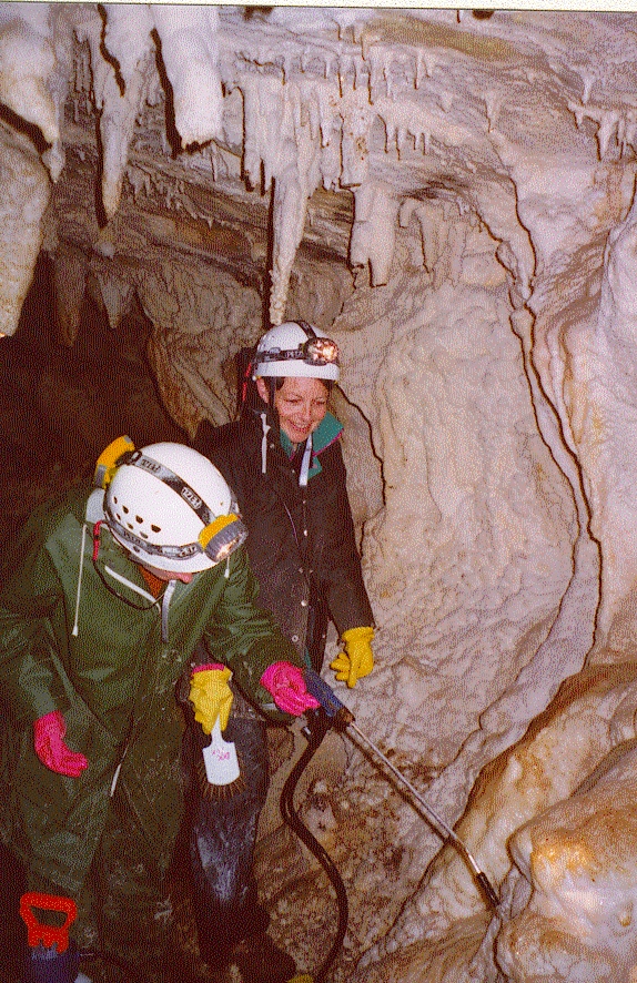 | 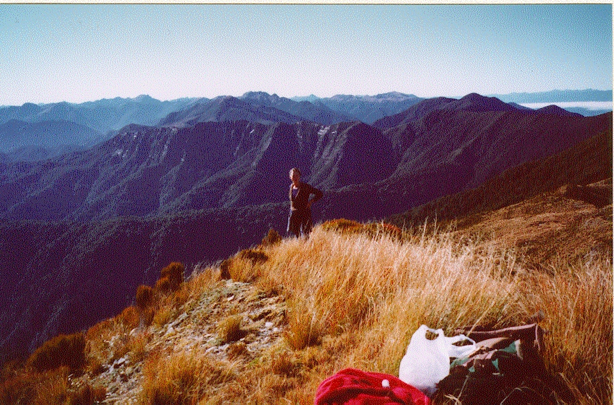 | 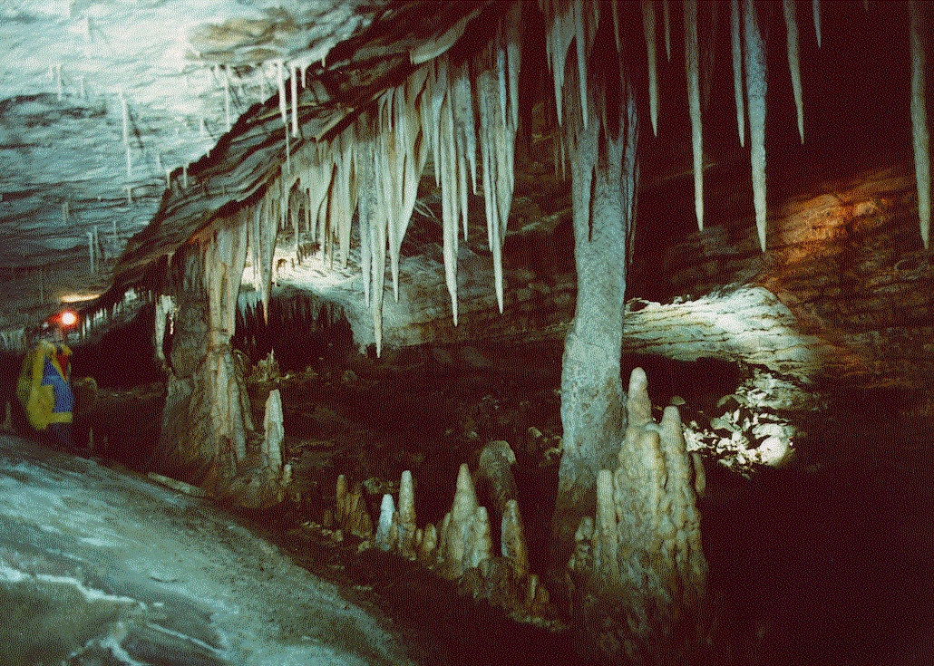 |
Various scenes, West Coast karst
4.1 MANAGEMENT ISSUES AND ACTIVITIES - USE
As recreational and visitor interest and tourist opportunities increase so does impact on the resources. With regard cave management the Department is currently concentrating its efforts on caves where visitor numbers are high, access issues have arisen and adverse impacts have increased. Of most concern at present is the Honeycomb Hill system although Metro and Fox River are being attended to as well.
4.1.1 Honeycomb Hill Caves
The Honeycomb Hill Caves lie within a Specially Protected Area in Kahurangi National Park. The geomorphology of this cave reflects a complex speleogenesis. It comprises a multi-level development, vadose and phreatic passages with complex epiphreatic maze systems where successive subterranean courses of the Oparara River have intersected each other. As a result more than fourteen kilometres of passages are found in an area 1000m by 800m. Unusual speleothems are common, many of indeterminate mineral composition. A significant population of Spelungula cavernicola spiders occurs and the cave contains internationally and nationally significant deposits of fossil bones. These resources have high conservation value and are the reason the cave has the highly protected status. One concessionaire operates in the limited access section of the cave, while the balance of the system is classified as restricted or closed.
Unpermitted entry into Honeycomb Hill has been a fluctuating problem over the years. A recent entry comprised unknown person/s abseiling into the Graveyard, a closed segment of Honeycomb Hill Caves which contains highly significant bird bone deposits. Another attempted to dig under the main gate.
Another issue was the abuse by some members of the local community of membership of NZ Speleological Society (NZSS). This gave a bad name to the majority by the few. Local business owners were joining NZSS and taking parties of clients through Honeycomb as permitted parties. One of these illegal operators was taking clients to fragile sites, moving bones about and lighting fires to make tea for clients in the closed areas.
All these activities have resulted in impact upon the resource, significantly in some places. As a result access to the Honeycomb Hill Caves is presently only via the tourist concession. Permitted entry will not resume until we are on top of the problems.
4.1.2 Metro (Ananui)
Metro or Ananui Cave is located in the northern outlier of Paparoa National Park. It is another extensive cave, comprising eight kilometres of generally large passages arranged in a complex maze. "The oldest mazes lie to the west and the youngest to the east, reflecting epiphreatic development. This development is of considerable geomorphic interest as these different levels can be correlated with outside terraces, aging the passage dates past sea levels" (Williams, 1982). Speleothem development is confined to the older levels and is significant in the Hall of Refugees, at the Dragon's Teeth and in Sunfish Passage. At the Triclops Entrance and in the Main Entrance threshold plants and associated biokarst is developed. A fairly wide range of cave fauna was found when first surveyed with troglobitic aquatic crustacea found in the small stream that enters the Conference Walk after flowing parallel and northeast of Sunfish. The cave was a significant location for subfossil deposits by Milner (Williams, 1980) with most fossil deposits in the older eastern passages associated with entrances. Pollen Passage contains extensive fine sediments and in mid 1997 the Department taped this passage to help protect its values and at the same time placed temporary signs advocating for careful behaviour.
Like Honeycomb Hill access is by permit or with a concessionaire. And like Honeycomb unpermitted entry has been a problem in this system too. Closer monitoring of permits issued for Metro has helped control access issues as has discussions with community residents who used local knowledge to gain access. This problem will never be entirely removed but interest in other caves and key people moving away has reduced the problem somewhat.
Digging up of passages has occurred off the tourist route and some pathways on the tourist route have been altered in the past three years. Taping of the tourist route in Metro over the past two years by the concessionaire, using the cement-bollard-and-white-tape method promoted at the Waitomo conference in 1997 has made a big difference in Metro. The taped route is very obvious and accords safe passage for visitors. There are still problems with the concessionaire adequately consulting with the Department and undertaking unapproved work. The Department is improving its profile in this area at present by visiting the cave more frequently.
4.1.3 Fox River Tourist Cave
This cave is located in Paparoa National Park and is a walk in/walk out, open access cave. It takes about an hour to walk to it from the State Highway and as it enroute to a popular camping spot further up the river it receives a significant level of use. The cave has been open to visitors for many years and although it contains significant speleothem development the level of damage is minimal. The main problem is the trafficking of mud into the cave from the entrance way and mud splashing on walls near the end of the passage if visitors slip off flagstones on the floor.
4.1.4 Xanadu System
This is a water-flushed, robust, open access system. Water floods through the seven kilometres of complex epiphreatic maze every time it rains, which is quite frequently on the rainforested West Coast. The system originates from several flood submergences in Bullock Creek. The largest single cave is the combined Xanadu/Cairns Catacombs/Kubla Khan system which has about five kilometres of known passage. The floors in the cave change regularly as result of flood events, particularly in the lower levels as gravels, mud and debris are washed down. The hydrology of the system has been studied in detail. The principle value of the cave is that it is a superb example of a epiphreatic maze and this is not likely to be compromised by visitor impact as it is very robust.
Periodically inexperienced cavers mark the passages with chalk which does not always wash off after the next flood event. This is the only problem that has occurred in Xanadu in the past few years.
4.1.5 New Caves
Increased prospecting by cavers has resulted in several new finds in recent years, e.g. Megamania, on land administered by the Department and by other agencies. As with all new finds damage is done at the first entry. The Department is keen to assess the values of new finds particularly if they are near facilities which will allow easy access and become potential tourist ventures.
4.2 MANAGEMENT ISSUES AND ACTIVITIES - PROTECTION
The Department undertakes a range of activities on the land it administers, some of which apply to karst areas alone, others which are generic management activities such as weed and pest control.
4.2.1 Science Activities
The Department of Conservation is increasing its research activities into the values and effective management of karst and cave systems, and a research strategy was developed in 1997.
a) The hydrology of the Bullock Creek system was examined by a PhD student in 1994. This research mapped the morphology and hydrology of the Paparao karst, identified the most important scientific features, delimited the most significant subterranean hydrological features, determined baseline water quality characteristics, and determined the evolution of the karst hydrology and geomorphology (Crawford 1994).
b) Paparoa National Park is host to at least 13 species of indigenous fish, some of which have been found above cave resurgences. Koura, the freshwater crayfish, are present in Honeycomb Hill Cave and albino specimens have been found in Metro Cave.
c) An experimental restoration programme of the Bullock Creek polje seeks to re-establish the hydrological regime in the extensively modified swamp. The predicted outcome will be an increase in the proportion of native wetland species to exotic species. The ability of this wetland to store water during a flood and release it more slowly afterwards may also be improved.
d) A survey and eco-taxonomic study of aquatic and terrestrial cave fauna in West Coast, Waikato, and Nelson-Marlborough cave and karst systems is about to begin. This will also cover lava cave systems in Auckland.
e) Field staff have been trained in the identification and ecology of rare and threatened plants of the Paparoa region, including those which are specialised and grow in cave entrances or are only found on limestone.
f) A Masters student compared visitor impacts in the low use Honeycomb Hill Cave and the high use Gardners Gut cave system in Waitomo (Bunting 1998). He carried out a resurvey of a photomonitoring programme carried out in 1986, and developed a method of assessing high use and low use sites.
g) A review of the effects of primary land use on cave and karst systems has been commissioned. This will allow the Department to advocate for appropriate land use controls in sensitive areas to avoid, remedy, or mitigate adverse effects.
h) Water from the Bullock Creek system will be tested before and after aerial drops of 1080 poison. This poison is used to control possums, which were introduced from Australia several years ago and which are in plague proportions in New Zealand now. 1080 is known to break down rapidly in biologically active (surface) water but we need to determine whether it enters underground waterways before it breaks down and, if so are there any adverse effects on cave fauna.
4.2.2 Operational Activities
Weed and pest control programmes are carried out to reduce the effects of exotic species such as possums, goats, stoats, old Mans beard, ginger, etc on conservation values within the Paparoa and Kahurangi National Parks. Conservation values include the calcicolous plant species and large carnivorous snails. Pest and weed control operations are monitored to determine whether there has been any adverse effect on the environment and if the conservation values benefit from the control.
4.2.3 Impact Monitoring
The West Coast Visitor Monitoring Plan proposes to collect numeric data, and carry out social and/or physical impact monitoring at key sites in order to monitor visitor trends, patterns of use, and to understand the effects of visitor use the Honeycomb Hill, Metro (Ananui), Fox River Tourist Cave and Xanadu. Visitor impact monitoring will use the methods established by Bunting (1998). Management will also be carried out in caves with known exiting impacts in order to mitigate these adverse effects.
5. Future
A number of actions are required by the West Coast Conservancy to achieve the objectives of the national and regional karst strategies and guidelines.
5.1 Strategic Directions
The Department's National Cave and Karst Strategy, which has existed as a draft for many years, is about to be approved. The document will provide a generic context for cave and karst management in the Waikato, Nelson/Marlborough and West Coast Conservancies.
Over the next twelve months the West Coast Conservancy will inventory its karst resources, list karst management, science and research documents and develop a schedule listing regional, national and international experts and their areas of expertise that would be useful for staff on the West Coast. This will lead into a review of the Conservancy's Cave and Karst Management Strategy and Operational Guidelines which will become the West Coast Karst Plan. This 'live' document will be reviewed annually to ensure objectives are being met and to incorporate new and improved ideas eg, suitable materials for use in caves and karst. Consideration will be given to integrating individual cave management plans into the document for ease of use. The extent of this will depend upon the issues related to the management of each cave.
The West Coast Conservancy will investigate the possibility of nominating the Bullock Creek polje as a RAMSAR Wetland. An assessment of the criteria will be undertaken and consultation will take place with karst managers in Australia and New Zealand to ensure complementary sites would be nominated from within those countries.
5.2 Advocacy and Education
The Department considers that information and education are key mechanisms it can use to raise awareness of the values of the resource, advocate for careful use and explain reasons for management decisions and actions. Along with the direct liaison with user groups such as NZSS, local caving groups, schools and Polytechs, the Conservancy's Cave and Karst Management Strategy, Publications and Interpretation Plans provide the policy and procedures for facilitating information and education activities.
Advocating for protection of karst values on land administered or owned by others is promoted in the CMS. World Wetlands Day will become an annual event following on from a successful advocacy promotion last year.
The Interpretation Plan has identified sites where interpretive panels will be installed over the next five years. A 'caves and karst package' will be designed to interpret sites in the Conservancy where visitor use is high and the site has high conservation values and/or is particularly fragile. Additionally, new information signs will replace faded signs in cave entrances explaining resource fragility and the need for careful behaviour and safe practice by users for themselves.
5.3 Monitoring
A monitoring programme will be set up so current conditions and known user numbers are recorded and used to help assess the effects of use over time. The main objective of the Visitor Monitoring Plan with regard physical monitoring is to sustain acceptable site conditions. Determining appropriate carrying capacity for each cave is also an important aspect of management. This is one of the reasons access to Honeycomb Hill Caves is restricted at present. We must establish the monitoring programme in conjunction with a record of past use to help determine future carrying capacity.
Concessionaires will be asked to contribute resources to the monitoring programme. The reason is two-fold - it is in their interest to sustain the resource in a sound condition and if they are part of the process their staff will learn to understand and appreciate the values of the resource and be able to impart this correctly to clients.
5.4 Physical Protection
Installation of barriers and gates will proceed in the 1999/2000 financial year in the Honeycomb Hill Caves and at Babylon. New and replacement taping will be undertaken in Honeycomb Hill, Metro, Fox River Tourist Cave and Babylon. Concessionaires and user groups will be invited to assist, some having already offered. In future concessionaires will be required to maintain the taping on the routes their operations use as per the Department's cave management programme.
5.5 Compliance and Law Enforcement
A compliance programme will monitor the cave for illegal activities and assess permit applications and tourism operations to ensure activities are maintained within agreements.
5.6 Training
Training is proposed for staff who work underground to ensure they have the appropriate competencies and relevant safety skills.
A Kaupapa Wahine cave clean-up project will take place in late May in the Fox River Tourist Cave to remove mud and graffiti. (Kaupapa Wahine projects are initiatives whereby women who work for the Department undertake an activity that brings them together to do something for conservation while at the same time strengthening the internal women's network and establishing a relationship with local community women who are invited to join the work party).
6. Conclusion
The West Coast karst is a resource of international significance. Most of the karst is under the management of the Department of Conservation or otherwise subject to protective provisions in District Plans or the Resource Management Act.
The Department endeavours to meet its responsibilities through the provisions of its National Policy and regional and local strategies such as the West Coast Conservation Management Strategy and the Caves and Karst Operational Plan. Iwi Maori interests are taken into account under the Ngai Tahu Deed of Settlement Act.
Although there are some pressing use related issues overall the karst resource is safeguarded by the ecosystem management approach, supported by an advocacy and education programme and dedicated staff.