The Geology and Geomorphology of the Gambier Karst Province
1 Regolith Mapping, PO Box 362, Hamilton, 3300, Australia (ken-grimes@h140.aone.net.au)
2 Department for Environment, Heritage and Aboriginal Affairs, Box
1046, Mt. Gambier, 5290, Australia, (kmott@dehaa.sa.gov.au)
3 School of Earth Sciences, La Trobe University, Bundoora, 3083,
Australia, (geosw@pop.latrobe.edu.au)
ABSTRACT
The Gambier Karst Province is an extensive area of Tertiary and Quaternary limestones in southeastern South Australia and western Victoria. This area of "soft rock" caves is developed on youthful, weakly-consolidated porous limestones and is syngenetic in part. The caves are characterized by cap rock effects, solution pipes, extensive low horizontal phreatic mazes, abundant collapse modification and extensive large flooded systems. The cenotes, large water-filled collapse dolines, are unique within Australia. There are large springs rising from flooded caves at the coast and offshore. Evolution of the caves is partly tied to the rise and fall of the sea, and associated water tables, during the Quaternary. The karst aquifer is one of the best in Australia, but careful management will be needed to maintain that quality. Management is also required to maintain the quality of the surface karst features, the caves and their environment.
INTRODUCTION
The 'soft-rock' karst region of south-east South Australia and western Victoria corresponds to a large extent with the Tertiary Gambier Basin (previously included in the Mesozoic Otway Basin; Smith & others, 1995), although caves in Quaternary dune limestone extend northwest across the adjoining Murray Basin. The region is generally low-lying and flat, with Quaternary dune ridges providing the most common relief. Locally, Quaternary volcanoes form unexpected hills. Many of the inter-dune flats were waterlogged for much of each year but have now been artificially drained. The Glenelg River is incised into the limestone to form a major gorge, and some rivers further east in Victoria are also incised. Coastal cliffs of limestone occur in many places, especially in the far east.
The karst is developed on poorly consolidated Tertiary and Quaternary limestones. It is also influenced by the thin younger sediments that overlie the limestones. Most of the karst is covered but some areas of bare karst occur southwest of Mount Gambier.
The climate of the western region is a 'Mediterranean' one with wet winters and cool dry summers. Annual rainfall increases towards the coast and from west to east; ranging from 550 mm in the Naracoorte area, through 850mm at Portland to nearly 1000mm at Port Campbell at the eastern end of the karst region.
During the Quaternary the present type of climate would have alternated with colder, drier and windier climates during the peaks of the glacial stages. The windy periods would be responsible for lunette ridges bordering some lakes, and possibly for deflation of some of the enigmatic shallow hollows in the old coastal plains. Much of the region would have been intermittently flooded by the sea during the interglacial periods of the early Quaternary.
GEOLOGY
See Marker (1975), Grimes (1994) and White (1994, 1995a & b) for details of the geology and karst systems. The limestones fall into two groups, both relatively young: the Tertiary (mainly Miocene) limestones of the Gambier Limestone and its equivalent Port Campbell Limestone further east, and the younger Quaternary calcareous dune limestones of the Bridgewater Formation and associated calcareous marine and coastal sediments of the inter-dune flats.
The Tertiary limestones were deposited in a shallow sea that flooded the region in the Oligocene and early Miocene (about 15-35 million years ago). Figure 1 shows the northern limit of these limestones for the purposes of modern cave development - they continue further to the north in South Australia, but with a progressively thicker cover of non-calcareous sediments. In Victoria the Tertiary limestones extend northwards beneath parts of the Newer Volcanics, but again the karst potential is limited.
The limestone is relatively soft in the subsurface but develops case hardening and calcrete cappings on exposure. It is locally well jointed with a dominant north-west trend in South Australia, but a north-east trend in the Port Campbell area. The influence of both the vertical jointing and the horizontal bedding are exhibited in the cave passage forms (e.g. Figure 12). The Tertiary limestones are similar to those in the Nullarbor, and there are similarities in the cave styles also, though here we have none of the huge passage systems that occur in the Nullarbor. The Kanawinka Fault and its related scarp have a major influence on the hydrology and karst development in the Naracoorte area (Figures 2 & 4).
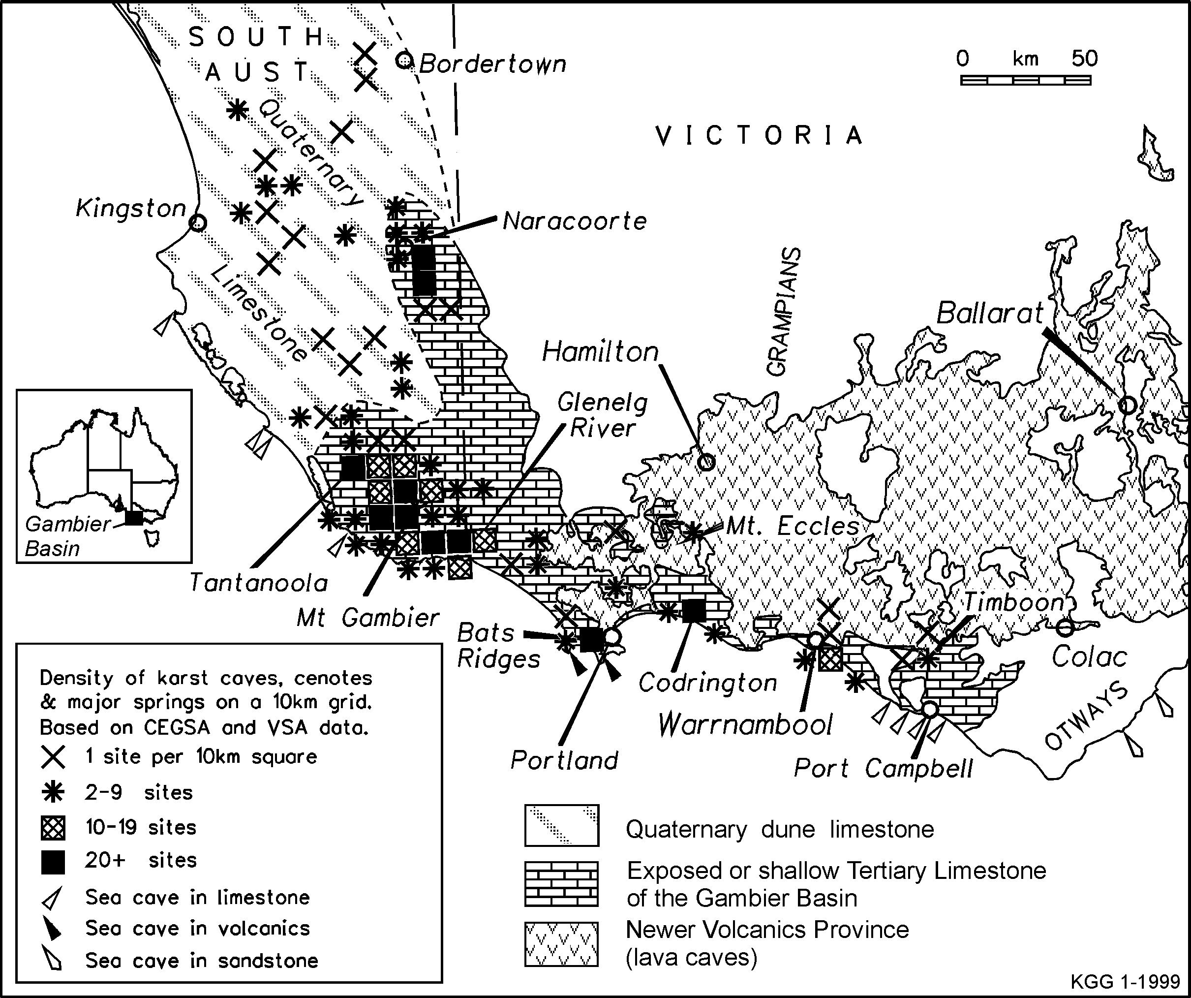
Figure 1: Distribution of caves and other karst features in the Gambier Karst Province.
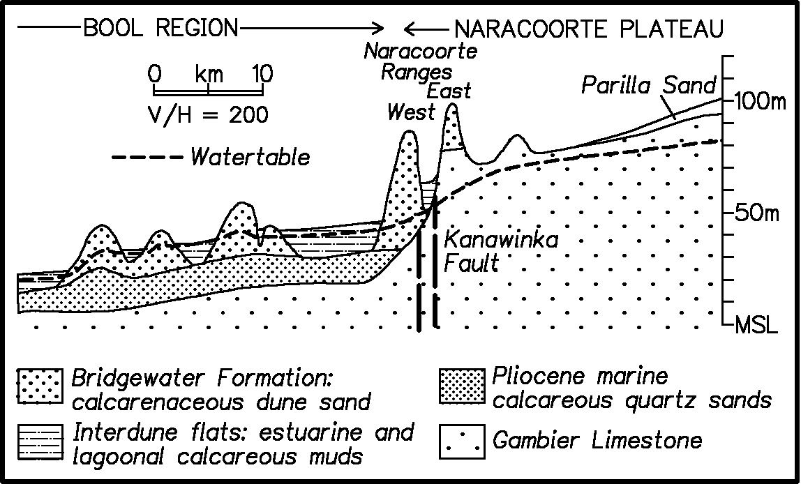
Figure 2: Cross-section in the Naracoorte area, showing watertable.
In the Bool Region (Figure 5) the Gambier Limestone is mantled by late Pliocene marine calcareous quartz sands up to 17 m thick (Figure 2, Cook and others, 1977). Towards the Victorian border these quartz sands grade into shelly calcareous sands and muds of the Pliocene to early Pleistocene Whalers Bluff Formation.
The Quaternary dune limestones are a series of calcareous coastal dunes along old shorelines that developed during an overall regression of the sea during the Quaternary. In South Australia they form linear north-west trending ranges (Figure 5), which extend northwards beyond the limit of the Gambier Basin to overlie the sediments of the Murray Basin. In Victoria the distribution of the dune limestones is less regular, and east of Portland they are mainly restricted to a belt along the modern coast, though some older ridges (mostly without karst) occur further inland.
These Quaternary limestones are similar to those on Kangaroo Island, the Eyre Peninsula, and the coastal areas of West Australia. The dune ridges are now partly consolidated calcarenites and contain syngenetic karst features in which caves and solution pipes developed as the sands were being cemented into a limestone (see later). The limestone has well-developed dune bedding with shallow-angle medium to thin bedding in places. It shows little or no jointing. Some caves are developed mainly in the underlying Tertiary limestones but have their entrances in the overlying dune limestones. Some younger, reworked, dunes are dominantly quartzose.
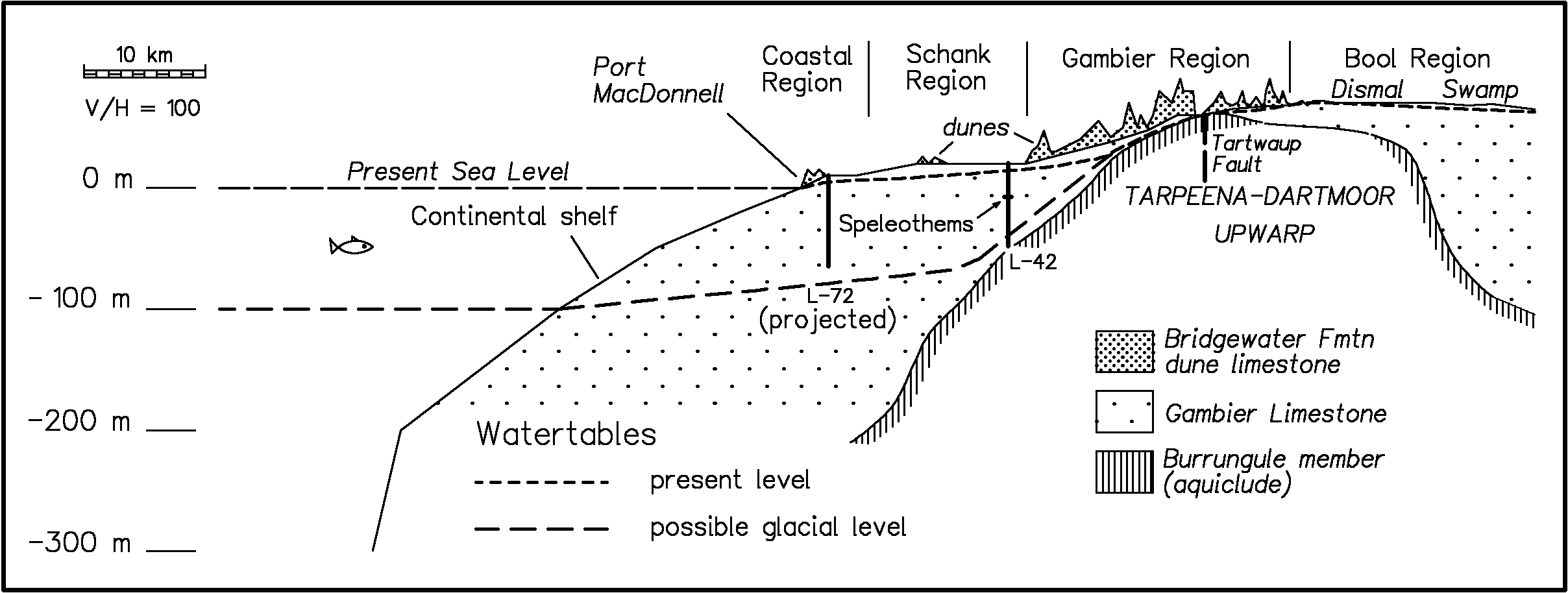
Figure 3: Cross-section in the Mount Gambier area, showing present and past watertables.
Between the dune ridges there are extensive swampy plains. These are old coastal flats and comprise estuarine to lacustrine limestones, dolomites, marls and clays up to 13 m thick (Figure 2). These plains have many shallow swampy depressions of complex origin (Figures 9 & 10).
Pliocene to Holocene basaltic volcanics form the extensive Newer Volcanic Province of Victoria (Figure 1), and some isolated volcanoes of this province occur in South Australia. The southern margin of the volcanic area overlies the Tertiary limestones. Lava caves are associated with several of the volcanoes in Victoria (Grimes, in press).
HYDROLOGY
The Tertiary Limestone forms a major aquifer in the region (Stadter, in press). The Gambier Limestone has been referred to as one of the best aquifers in Australia (Holmes & Waterhouse, 1983). Much of the ground water from the Mount Gambier area is discharged in major springs along the southern coast, and divers have entered caves below some of these.
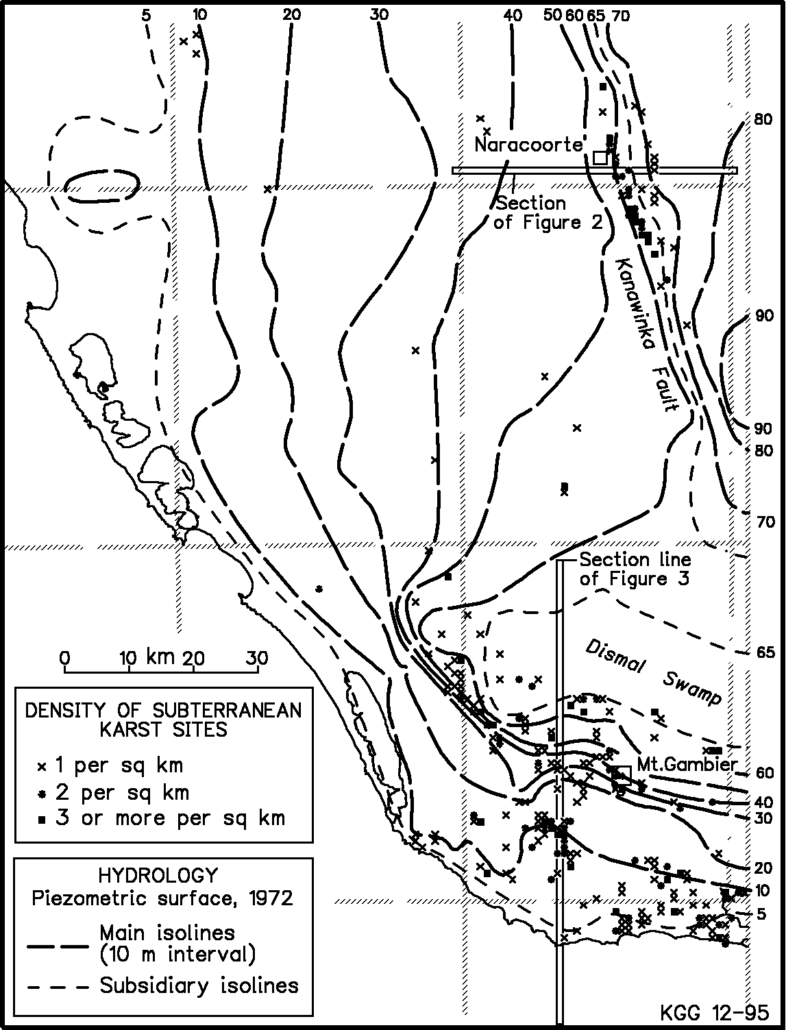
Figure 4: Ground water contours, after Holmes & Waterhouse (1983).
Submerged mud-cracks in Iddlebiddy Cave indicate a lower water table in the past. The laminated bedding suggests deposition in a still-earlier lake when water tables were higher. (Photo by G. Bulling.)
At the regional scale the Gambier Karst shows many characteristics of a porous aquifer; for example, it has a continuous, well-defined water table and the springs show none of the "flashy" behaviour of conduit driven karst aquifers (Holmes & Waterhouse, 1983). On the other hand the transmissivity in places is much higher than one would expect from the porosity of the limestone alone (Telfer, 1993, Emmit & Telfer, 1994), and at the local scale we see the typical irregular and unpredictable characteristics of conduit aquifers (Emmit & Telfer, 1994). The aquifer is unconfined, deep, and open (uncapped). Most water comes from rain and normally enters the aquifer diffusely through the porous surface sands, but some point input occurs via "runaway holes" in dolines (Herczeg & others, 1997). Some water enters from the allogenic Glenelg River, and further east in Victoria there are other allogenic rivers that rise outside the karst area but cross it on the way to the sea.

Figure 5: Karst regions and geology in south-eastern South Australia.
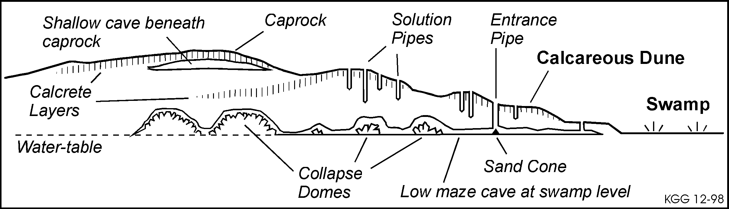
Figure 6: Features of syngenetic karst developed on a calcareous dunefield.
In South Australia there is a well-developed water table. This has a gentle slope towards the coast, with two zones of steeper gradients (Figure 4, Holmes & Waterhouse, 1983). One of these is along the line of the Kanawinka Escarpment (Figure 2), and the other passes north-west through Mount Gambier (Figure 3). Marker (1975) noted a correlation between high cave densities and the zones of steep gradients, and also with areas of greater than normal depth to the water table.
During glacial periods the lowering of sea levels would have caused a significant drop in the ground water levels in the coastal parts of the region - as shown by submerged speleothems and mudcracks in some South Australian caves. There is also evidence for recent drops in the water table. For example, stromatolites are found up to 2m above the present water level in the cenotes, and there are historical records of higher levels in some cenotes. Fluctuations of over a metre have been recorded in association with land clearance (a rise) and the growth of pine plantations (a drop).
KARST LANDFORMS
Karst Regions within the Gambier Karst Province
Marker (1975) and later Grimes (1994) divided the South Australian part of the Gambier Karst Province into several distinctive regions (Figure 5). In Victoria the Tertiary limestones are variable in their purity, and only limited parts of that region show significant karst development. The regional characteristics are described in Grimes (1994), Grimes & White (1996) and Grimes & others (1999).
Syngenetic Karst and Soft Rock Karst
In the calcareous Quaternary dunes some karst features are syngenetic, in that they have developed at the same time as the sand was being cemented into a rock (Jennings, 1968; White, 1989, 1994, Grimes & Spate, 1997). Unconsolidated calcareous sand is converted to limestone gradually by solution and redeposition of calcium carbonate by percolating water. This initially produces a caprock or calcrete layer near the surface which is capable of supporting the roof of a cave (Figure 6).
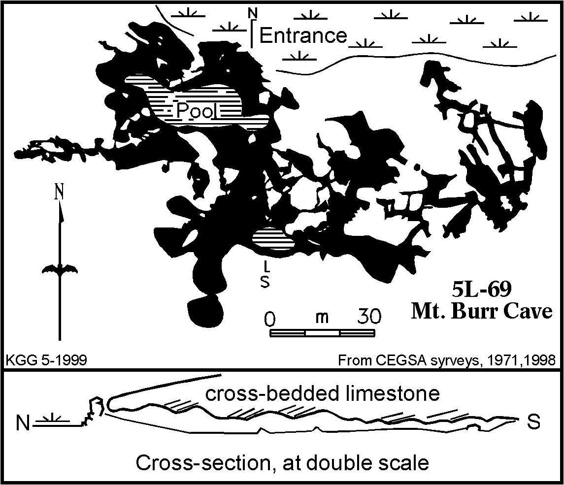
Figure 7: Mount Burr Cave is a typical syngenetic karst cave developed in Quaternary dune limestone adjacent to a swamp. Extent of the pool is that seen in 1991.
The downward percolating water also dissolves vertical solution pipes, and simultaneously cements the surrounding sand. At the same time, enhanced mixing corrosion (Spate, 1990) occurs where percolation water meets the water table - typically at the level of an adjacent swampy plain. In the early stages, when the sea was present adjacent to the dune ridges, mixing between a freshwater lens and an underlying body of sea water could have also contributed to the development of horizontal maze caves. This is the "flank margin" model of Mylroie & others (1995) developed for the soft-rock caves of the Bahamas. In Australia this sea water effect may have less importance than the swamp waters.
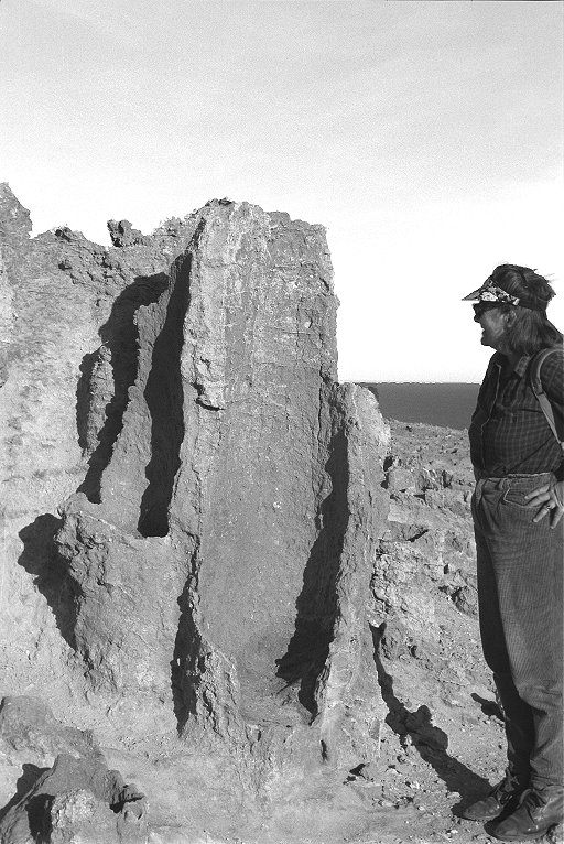
Solution pipes with cemented rims. The "Petrified Forest" west of Portland. (Photo by K. Grimes)
The main characteristics of syngenetic karst are the development of a cemented (calcreted) caprock near the surface, of vertical solution pipes, and of low, wide, horizontal maze caves either beneath the caprock or at the level of the adjoining swampy plains (Figures 6 & 7). The poorly consolidated nature of the rock means that collapse plays a very important role from an early stage. Re-cemented breccias are seen in the walls of several of the dune limestone caves.
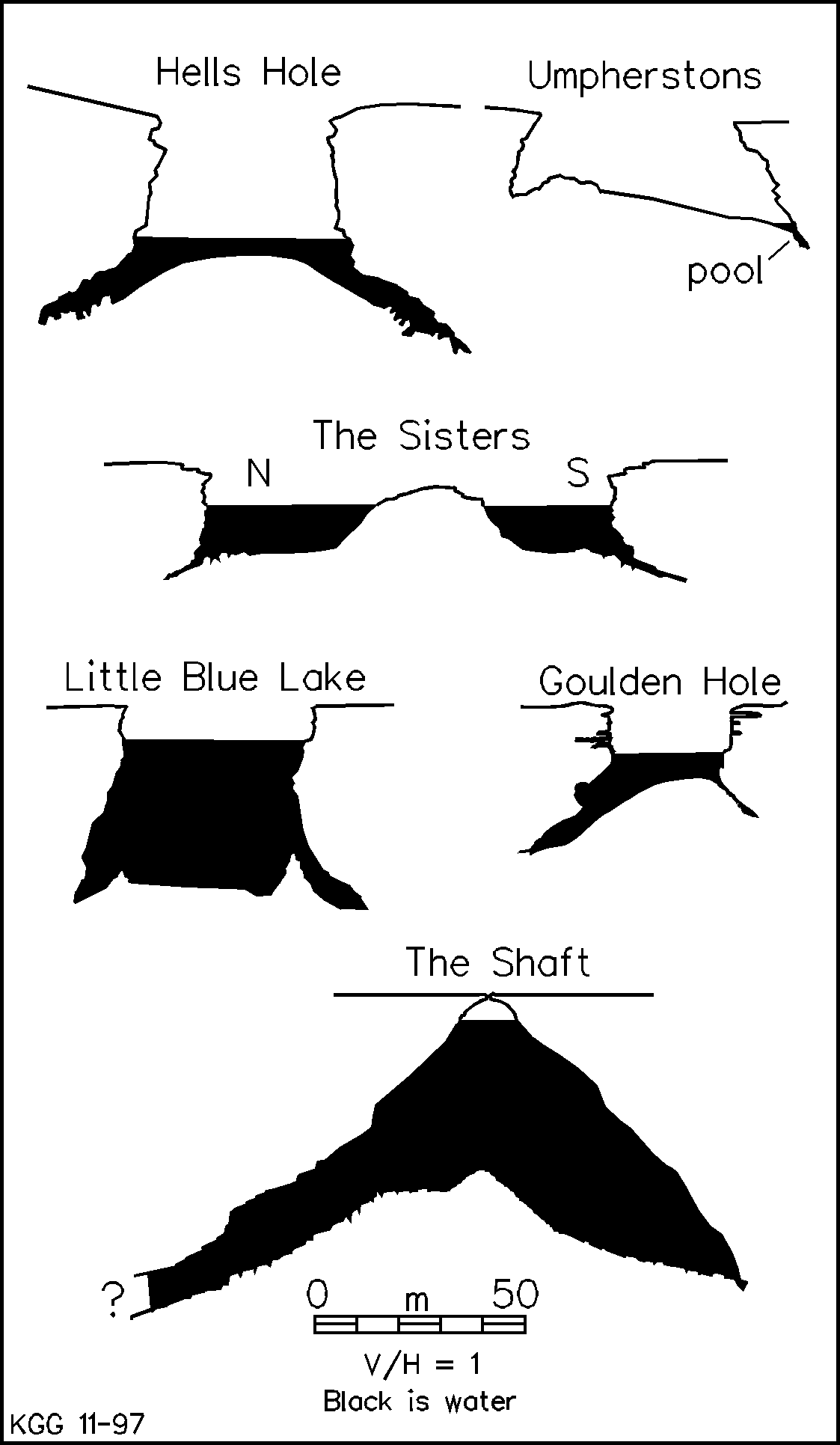
Figure 8: Cross-sections of typical cenotes. The Shaft represents the precursor cavern.
Solution pipes are one of the most distinctive features of syngenetic karst. They are vertical cylindrical tubes, typically 0.5 to 1 m in diameter, which can penetrate down from the surface as far as 20 metres into the soft limestone. The pipes may be associated with roots (though which came first is debatable), and their margins show a case-hardened cylinder. They occur as isolated features, or in clusters with spacings as close as a metre or so. Many of the caves are entered via such pipes.
Syngenetic karst development is typical of the Quaternary dune calcarenites; however, the Tertiary limestone is also a relatively soft porous limestone, and consequently it shows some of the features of syngenetic karst, in particular the development of solution pipes and calcreted caprocks.
Surface Karst
Surface karst features are extensive in some parts of the area, but inhibited by thick cover material in others. Features include uvalas, dry valleys, a variety of doline types, exposed subsoil karren and coastal phytokarst.
The most spectacular surface karst features are the collapse dolines, especially those in the Mount Gambier area that extend below the water table to form cenotes. These have formed by the collapse of large phreatic caverns. Figure 8 shows several typical cenotes and related features. In the Gambier region the watertable is lower and the collapse dolines have only shallow lakes (e.g. Hells Hole & Umpherstons), however, further south in the Schank region, the water levels are higher and we find deep lakes (e.g. Little Blue Lake). The Shaft (Figure 8) is an example of the situation before the roof of a large flooded collapse dome fell in to form a cenote - the present entrance is a small solution tube.
Fields of shallow pans and dolines are extensive in South Australia and extend into the westernmost part of Victoria (Figure 9). Isolated doline fields also occur further east. These shallow hollows generally have sandy or muddy floors and rarely have cave entrances.
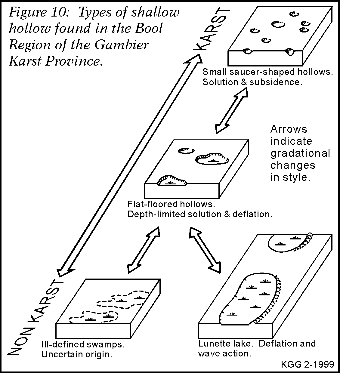
In the Pleistocene coastal plains which form the Bool Region many of the shallow hollows are polygenetic; with solution, deflation and other processes operating in parallel, or in sequence, or alternating in step with glacial - interglacial climatic fluctuations. The resulting hollows range from small well-defined saucers which appear to be true karst to large shallow lunette lakes which appear to owe their origin mainly to deflation and wave modification of primary coastal lagoons, though there is a possibility of subjacent karst influences in places (Figure 10, Grimes, 1996). Some ill-defined hollows are irregular in plan or form chains which suggest the influence of the original drainage on the coastal plain.
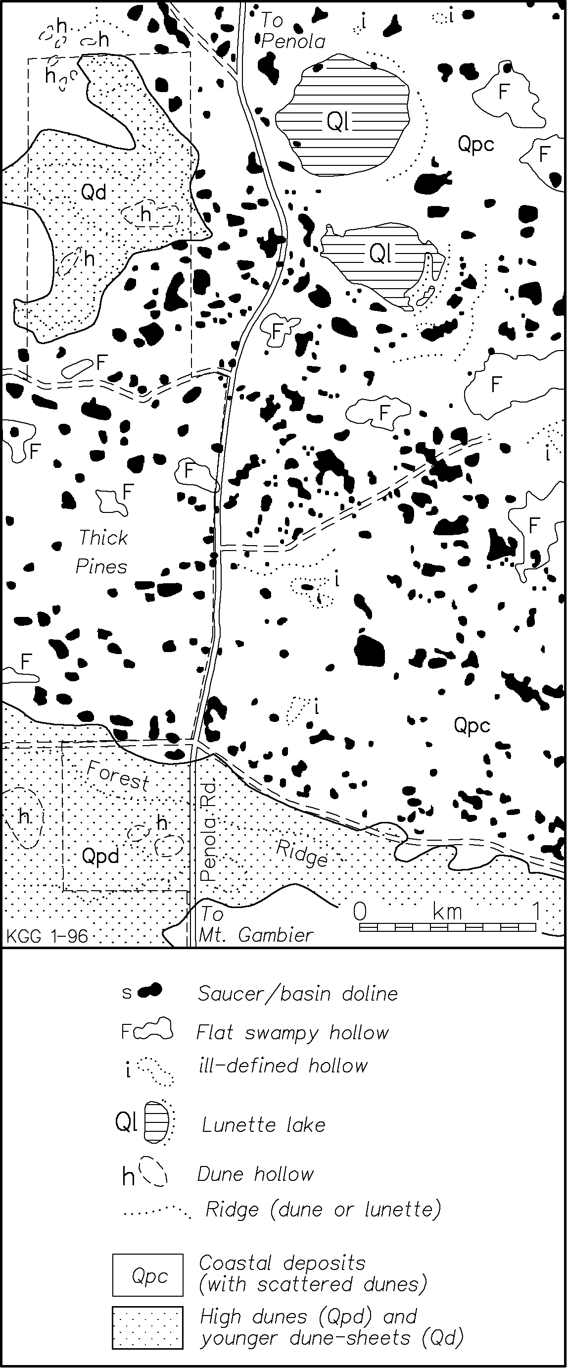
Figure 9: Part of Dismal Swamp, in the Bool Region, showing the variety of shallow hollows.
In the dune ridges many of the larger depressions are primary dune hollows, but these may be modified by small solution dolines to produce uvala-like features. The distinction between dune hollows and karst depressions is difficult to make in many areas.
Caves
The caves in the Tertiary limestones are dominantly phreatic in origin, i.e. formed by slow moving ground water at and below the water table. The syngenetic caves are mainly epiphreatic - formed in the zone of mixing just below the water table; but vertical vadose seepage is responsible for the solution pipes. The limited local relief means that vadose stream flow features are extremely rare in South Australia, but some vadose streams occur in the caves of the Glenelg River gorge in westernmost Victoria, and also further east in the Warrnambool and Timboon regions. Both joint and bedding-plane control can be seen, but solution at temporary water-table levels can make the latter hard to recognise in this area of flat bedded limestone. Many of the primary phreatic caverns and passages have been modified by breakdown to form collapse domes and rubble filled passages (Figure 11).
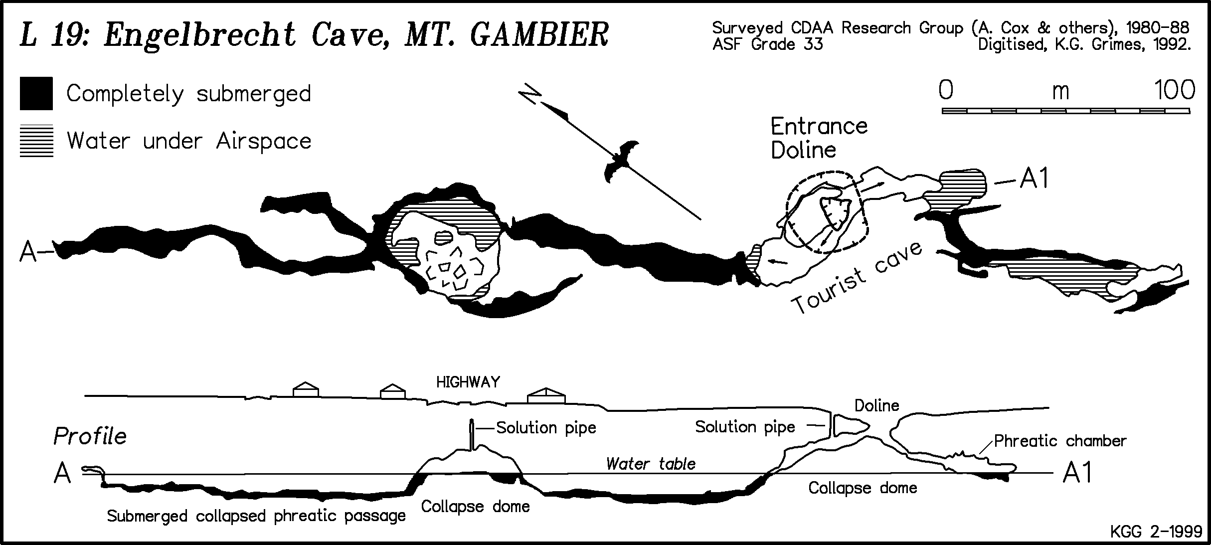
Figure 11: Engelbrecht Cave is a mostly-submerged system developed in the Tertiary limestone beneath the city of Mount Gambier.
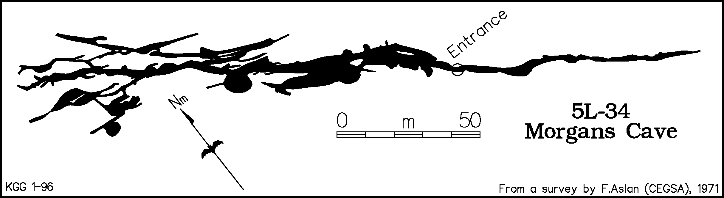
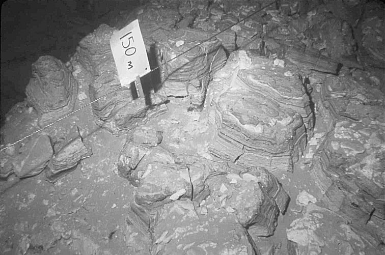
Figure 12: Morgans Cave shows strong joint control in the Tertiary limestone.
Cave diving has demonstrated the existence of extensive underwater cave systems in South Australia. It appears that south of Mount Gambier the bulk of the cave development may be below the present water table though these passages would have been partly or wholly drained during the low sea levels of the last glacial period.
Typical syngenetic cave forms in the Quaternary dune limestones are shallow horizontal systems developed beneath the caprock or at the level of an adjoining swamp (Figure 6). They have multiple entrances (often via solution pipes or the collapse of the surface crust) and an irregular outline of chambers, pillars and short connecting passages, generally with a roof height less than one metre throughout (Figure 7). The walls are often difficult to see (and map) as they are out of reach where the roof gradually drops to floor level.
The caves in the Tertiary limestone are similar but generally have larger chambers and passages, and also show better joint control, with many fissure-style passages (Figures 11 & 12).
Speleothems are generally not abundant - a consequence of the frequent collapse. However, there are some spectacular exceptions to that rule, and these include some extensive and very delicate forms; especially clusters of long straws and soft deposits of moonmilk. Moonmilk is composed of micro-crystalline carbonate needles with a high water content between the crystals and is generally rare in limestone areas in eastern Australia. Cave-coral is also well developed. Still pools may be partly covered by calcite rafts.
CAVE BIOLOGY
There are two maternity sites for the Bentwing Bat (Miniopterus schreibersii) - one near Naracoorte and one at Warrnambool (Dwyer, 1969). Several caves along the Glenelg River host the (locally) rare Large Footed Bat (Myotis adversus). The cenotes and big springs contain an interesting aquatic fauna and flora - including stromatolites and small crustaceans called syncarids (Thurgate, 1995, 1996a & b). The stromatolites are columnar or platy underwater calcareous growths formed by algae. These have been found as deep as 25m, and also extend 2m above the present water level - implying a higher watertable at some time in the past. Elery Hamilton Smith (pers. comm.) has photographs that suggest that this might have been as recent as the 1950s.
The solution pipes and collapse dolines form excellent pitfall traps and thus bone deposits of Quaternary age have been found in many caves (e.g. Wells & Pledge, 1983). The most important, and world famous, bone deposit is in the Victoria Fossil Cave at Naracoorte (Wells & others, 1984), but significant bone sites occur in both states, including some underwater bone deposits in the cenotes.
The Tertiary limestones in the Mount Gambier area have bands of flint nodules which make excellent stone tools. Evidence of aboriginal mining of flint is seen in several caves, as is also aboriginal art in the form of scratch marks and finger marks (Bednarik, 1986).
MANAGEMENT
Water Supplies
The Gambier Limestone has been referred to as one of the best aquifers in Australia (Holmes & Waterhouse, 1983). Unfortunately it has also suffered from various forms of pollution and over-exploitation (Emmit & Telfer, 1994, and see also papers by Stadter, Schmidt, Hopton and Thurgate elsewhere in the current proceedings volume). There may be a growing problem in maintaining supplies in the face of increasing demand for private, agricultural and industrial usage. Water quality can be compromised by pollution from a variety of sources: stormwater, sewer and septic drainage in the towns, farm activities (in particular wastes from the dairies and piggeries), and some major industries such as those involved in the timber business (treatment of mill timbers, paper pulp, cellulose etc.). In the past, abattoirs have been a source of pollution with some still a cause for concern. Cheese factories also introduced major pollution plumes into the aquifer and these are still travelling through the system.
Of increasing concern is contamination of the groundwater from diffuse sources such as grazing (Harvey, 1982). In some areas, particularly in the north, increased salinity from clearance and irrigation is becoming a greater problem.
Although regulatory controls exist under the Environment Protection Act these only cover large scale operations. Small scale operations come under a general duty of care and are usually only scrutinised when there is a direct complaint. Often a number of small, badly run, operations can cause more problems than the reasonably run large ones. Unfortunately, these small operations have more severe budgetary constraints so the owners are more reluctant to upgrade, despite programs of public education.
Surface karst management
The main problems here have to do with introduction of pollutants into the aquifer via the dolines, cave entrances and "runaway holes". Infilling and direct damage to dolines and cave entrances also occurs from forestry and agricultural activities. Many dolines and entrances have been, and still are, used as rubbish dumps. There have been major clean-ups of some dolines and caves, for example: Engelbrecht Cave in the town of Mt Gambier is now a tourist cave, and Rendelsham Cave near Millicent has recently been cleaned up and developed as a recreational area. The stromatolites that grow in the cenotes may be endangered by water pollution; either directly or indirectly by the growth of surface algal mats which block the sunlight (Thurgate, 1996). Swimmers in some of the spring ponds have caused damage to the aquatic vegetation. Ripping of limestone for increasing irrigation activity can disturb karst pavement areas and change the hydrology. Subsequent irrigation or intensified land usage will also have an impact from increased fertiliser applications.
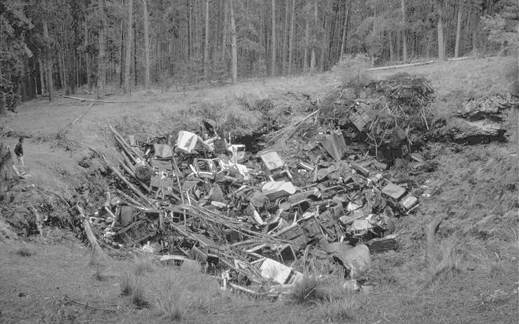
Circuit Sinkhole in the Caroline Forest (exotic pines) continues to be used intermittently for dumping rubbish. (Photo by K. Grimes)
Cave management
Management problems within the caves are mainly related to people access, and the damage that results therefrom. About a third of the known caves in South Australia are on crown land (mainly State Forests). The province has four sets of show caves: Several caves at The Naracoorte Caves, and also Tantanoola Cave, Engelbrecht Cave in Mount Gambier, and Princess Margaret Rose Cave on the Glenelg River. Diving in caves and cenotes is a special activity in the Mount Gambier region that is stringently controlled by a certificate and permit system (Collins, this volume). Beneath pine plantations evapotranspiration is much higher than elsewhere and this can drop the local water table by several metres, drying up cave pools and speleothems. A few caves have been intersected by quarries; one of these became a major fossil bone site - with the quarry operations continuing beside it (Barrie, 1997). A worry with syngenetic karst caves, and to a lesser extent with those in the Tertiary Limestones, is stability. "Soft-rock caves" are not as strong as the typical "hard-rock" cave of the east coast, and so roof fall is statistically more likely. This is not a major problem, but cavers have to be a bit more careful about bumping the roof, and cave managers should do regular inspections of their tour caves.
CONCLUSION
This area of 'soft rock' caves developed on youthful, weakly-consolidated porous limestones is quite different from the 'hard rock' indurated Palaeozoic limestone karsts of eastern Australia. The caves have an entirely different quality, characterised by cap rock effects, solution pipes, extensive low horizontal phreatic mazes, abundant collapse modification and extensive large flooded systems. The cenotes are unique within Australia. The karst aquifer is one of the best in Australia, but careful management will be needed to maintain that quality. Management is also required to maintain the surface karst features, the caves and their environment.
REFERENCES
BARRIE, J., 1997: Climatic indicators within Henschke fossil cave system, Naracoorte, South Australia. Quaternary Australia, 15(2), 45-57.
BEDNARIK, R.G., 1986: The parietal art of South Australia. Journal, Anthropological Society, South Australia. 24(1) 3-21.
COLLINS, T., in press: Cave diving management in the Lower south East - South Australia. in HENDERSON, K. [ed] Cave and Karst Management in Australasia, 13. Australasian Cave and Karst Management Association, Carlton South. (this volume).
COOK, P.J., COLWELL, J.B., FIRMAN, J.B., LINDSAY, J.M., SCHWEBEL, D.A. & VON DER BORCH, C.C., 1977: The late Cainozoic sequence of south-east South Australia and Pleistocene sea-level changes. BMR Journal of Australian Geology & Geophysics, 2: 81-88.
DWYER, P.D., 1969: Population ranges of Miniopterus schreibersii (Chiroptera) in south-eastern Australia. Australian Journal of Zoology, 17: 665-686.
EMMIT, A.J., & TELFER, A.L., 1994: Influence of karst hydrology on water quality management in southeast South Australia. Environmental Geology, 23(2): 148-155.
GRIMES, K.G., 1994: The South-east Karst province of South Australia. Environmental Geology 23: pp 134-148.
GRIMES, K.G., 1996: Pans, dolines and other hollows in the South-east Karst province of South Australia. in HAMILTON-SMITH, E., [ed], 1996, Abstracts of papers, Karst Studies Seminar, Naracoorte. Regolith Mapping, Hamilton, Victoria : pp 3-4.
GRIMES, K.G., in press: Volcanic caves and related features in western Victoria. in HENDERSON, K. [ed] Cave and Karst Management in Australasia, 13. Australasian Cave and Karst Management Association, Carlton South. (this volume)
GRIMES, K.G., & SPATE, A.P., 1997: Andysez No. 25: Lets talk about Limestone - Part 2. ACKMA Journal, 29, 33-34.
GRIMES, K.G., & WHITE, S., 1996: Field Guide to karst features in Southeast South Australia and Western Victoria. Karst Studies Seminar, Naracoorte. Regolith Mapping, Hamilton. 34pp.
GRIMES, K.G., MOTT, K., & WHITE, S., 1999: Field Guidebook to karst and volcanic features in Southeast South Australia and Western Victoria. Australasian Cave and Karst Management Association, 13th Conference. Mount Gambier. 34pp.
HARVEY, P.D., 1983: Groundwater pollution related to land use in a karst area. International Conference on Groundwater and Man. AWRC, Sydney. 131-142.
HERCZEG, A.L., LEANEY, F.W.J., STADTER, M.F., ALLAN, G.L. AND FIFIELD, L.K., 1997: Chemical and isotopic indicators of point?source recharge to a karst aquifer, South Australia. Journal of Hydrology, 192: 271?299.
HOLMES, J.W. & WATERHOUSE, J.D.. 1983: Hydrology. In TYLER M J, TWIDALE C R, LING J K, and HOLMES J W (eds) 1983 Natural History of the South East. Royal Society of South Australia, Adelaide, pp. 49-59.
JENNINGS, J.N., 1968: Syngenetic karst in Australia. in Contributions to the study of karst, Australian National University, Dept of Geography Publication G/5, pp 41-110.
MARKER, M.E., 1975: The lower southeast of South Australia: A Karst Province. Department of Geography and Environmental Studies, University of Witwatersrand, Occasional Paper, 13.
MYLROIE, J.E., CAREW, J.L. & VACHER, H.L., 1995: Karst development in the Bahamas and Bermuda. Geological Society of America, Special Paper 300, 251-267.
SMITH, P.C., ROGERS, P.A., LINDSAY, J.M., WHITE, M.R., & KWITKO, G., 1995: Gambier Basin. in DREXEL, J.F. & PREISS, W.V., (Eds), The Geology of South Australia, Volume 2 The Phanerozoic. South Australia, Geological Survey, Bulletin, 54, pp 151-157.
SPATE, A.P., 1990: Andysez No. 3: Carbonate solution made easy(ish). ACKMA Journal, 6, 24-25.
STADTER, A., in press: Regional Hydrology. in HENDERSON, K. [ed] Cave and Karst Management in Australasia, 13. Australasian Cave and Karst Management Association, Carlton South. (this volume). [EDITOR - insert page numbers etc ....]
THURGATE, M.E., 1995: Sinkholes, caves and spring lakes: an introduction to the unusual aquatic ecosystems of the Lower South East of South Australia. South Australia Underwater Speleological Society Occasional Paper 1.
THURGATE, M.E., 1996a: The stromatolites of the cenote lakes of the Lower South East of South Australia. Helictite, 34(1), 17-25.
THURGATE, M.E., 1996b: Stromatolites of the karst lakes of the Mt. Gambier Region. What are they and why should we care? ACKMA Journal, 23, 29-33.
WELLS, R.T., MORIARTY, K., WILLIAMS, D.L.G., 1984: The fossil vertebrate deposits of Victoria Fossil cave: an introduction to the geology and fauna. Australian Zoologist 21(4), 305-333.
WELLS, R.T., & PLEDGE, N.T., 1983: Vertebrate fossils. in TYLER M J, TWIDALE C R, LING J K, and HOLMES J W (eds) 1983 Natural History of the South East. Royal Society of South Australia, Adelaide, pp 169-176.
WHITE, S., 1989: Karst features in Pleistocene dunes, Bats Ridge, Western Victoria. Helictite, 27(2): pp 53-71.
WHITE, S., 1994: Speleogenesis in aeolian calcarenite: A case study in western Victoria. Environmental Geology, 23: pp 248-255.
WHITE, S., 1995a: Tertiary limestone areas of western Victoria. In BADDELEY, G., (ed) Vulcon Guidebook, Victorian Speleological Association, Melbourne. pp 69-80.
WHITE, S., 1995b: Quaternary limestone areas of western Victoria. In BADDELEY, G., (ed) Vulcon Guidebook, Victorian Speleological Association, Melbourne. pp 81-98.