The Dismal Swamp Polje of northwest Tasmania: A Case Study in Geo-conservation
ABSTRACT
"Geoconservation" is a unifying term which is increasingly being used to describe the management of geological, landform and soil features and systems for their nature conservation values. In Australia, the management of karst landform systems has to a large extent been the catalyst for the development of the concept of geoconservation generally. The practical on-the-ground management aspects of geoconservation involve little that is radically new or unprecedented; for example, many of Australia's cave reserves, some dating from the last century, were reserved for reasons which would today be described as geoconservation-oriented. However, the philosophical impact of the idea of geoconservation as a new unifying conceptual framework has provoked a strong adverse reaction from some sections of the bedrock geology community, and in particular the mining industry. The Dismal Swamp polje of northwest Tasmania has recently been a focus for mining industry opposition to the concept of geoconservation, and this paper examines both the scientific and some of the political and ethical aspects of this test case.
The Tasmanian Forestry Commission previously accepted that Dismal Swamp is a polje - a rare karst landform in Tasmania and one of the best examples of its type in Australia - and thus accepted the need for appropriate management prescriptions for the landform and associated natural processes. In contrast, an element within the mining industry has recently attempted to discredit Tasmanian practitioners of geoconservation by attempting to disprove the assertion that Dismal Swamp is a polje, and to thereby show that geoconservation is based on poor science and that conservation management prescriptions for the feature are unwarranted. This paper reviews the arguments that were presented and also - relevantly - the manner in which they were presented. The elements defining a polje are reviewed, and field studies at Dismal Swamp are described which show that it is difficult to explain the landforms and hydrology of Dismal Swamp as anything other than those defining a polje.
The experience of the Dismal Swamp controversy is drawn upon to identify possible reasons for the strident opposition to the concept of geoconservation by certain elements of the mining industry and the bedrock geology community. It is suggested that some factors in this opposition may include fears of resource alienation based on an ignorance of the realities of geoconservation management, an unprofessional reluctance to admit uncertainty about anything prefixed "geo" and seek information on what geoconservation actually involves, a resistance among some geological practioners to acknowledging the validity of non-utilitarian nature conservation values, and an unwarranted sense of exclusive intellectual ownership of anything associated with the prefix "geo". Concluding on a more positive note, it is suggested that the concept of geoconservation has nonetheless achieved a considerable degree of recognition and acceptance amongst some relevant agencies, notably including Mineral Resources Tasmania.
INTRODUCTION
This paper examines some reactions to the concept of "geoconservation" by the some elements of the geological profession and mining industries in Tasmania. The management of karst landforms has always been a central issue in geoconservation - indeed, karst management was arguably the primary catalyst for the development of the concept in Australia - and one particular karst landform in Tasmania, the Dismal Swamp polje, has been a focus of recent attention towards geoconservation by the mining industry.
This paper draws together a number of issues: scientific, philosophical, ethical and political. It is divided into a number of related sections which can, however, be read separately. The paper provides an up to date outline of some basic principles of geoconservation, a scientific account of the Dismal Swamp polje of northwest Tasmania, and an account and discussion of reactions to the concept of geoconservation by representatives of a major sector of the geological profession.
GEOCONSERVATION
The term "geoconservation" is being increasingly used in Australia, Europe and elsewhere to refer to the conservation of geological (bedrock) features, landforms and soils for their nature conservation values (e.g., Kiernan 1995, Eberhard 1997, Spate et al. 1998, Williams 1998, Doughty 1999). The term has been adopted by a group of Tasmanian land management professionals, of whom the writer is one, working within agencies including the Tasmanian Parks and Wildlife Service, Forestry Tasmania and the Tasmanian Forest Practices Unit. The meaning of the term 'geoconservation' as described in this paper is that used and advocated by the latter workers.
Geoconservation can be defined as: the identification and conservation of geological, geomorphological and soil features, assemblages, systems and processes (geodiversity) for their intrinsic, ecological or heritage values. (Eberhard 1997, p. v) . One of the important things to grasp about this definition is that it defines geoconservation as an approach which is philosophically distinct from some other earth science - based approaches to land management, such as 'Environmental Geology' (e.g., Bell 1998). The latter discipline essentially focuses on utilitarian or anthropocentric values; that is, it seeks to predict, prevent or mitigate the degradation of landforms, soils and water quality by geomorphic hazards such as landslips, soil erosion, or karst subsidence, so as to minimise the impact such hazards may have on human aspirations for use of the land (Kiernan 1990a, p. 8).
In contrast to this philosophically utilitarian approach, the focus of geoconservation is on preventing degradation in order to conserve bedrock, landform and soil systems for their value as natural systems, as well as for their utilitarian value to humans; that is it incorporates an ecocentric view of conservation values as well as an anthropocentric one. This approach also implies that nature conservation should be seen as having at least two primary and complementary aspects, namely geoconservation and bioconservation. All too often it seems to be the case that nature conservation is seen as being synonymous with bioconservation alone, neglecting the fundamental and essential role that the non-living substrate - bedrock, landform systems, soils and associated waters - plays in natural processes including ecological processes, and neglecting also the fact that non-living parts of the natural environment can be considered to have intrinsic value just as the living parts can (Sharples 1995). No approach to nature conservation which ignores geoconservation makes sense, or indeed is possible.
The writer considers the concept of geoconservation to be an advance on the older "geological monuments" or "geological heritage" approach of the Geological Society of Australia, which (officially) still recognises geological features as having value or significance only in terms of their value for research and education (Legge & King 1992). Whilst geoconservation incorporates the idea of protecting geological features for their research and educational value (i.e., their scientific values), it goes beyond this by recognising that natural geological, geomorphic and soil systems have intrinsic value beyond their value to science, and are also important as the fundamental natural systems upon which all ecological processes are based. Further, whereas the geological heritage approach tends to focus on small sites, geoconservation emphasises the importance of broader natural processes in maintaining the features and systems which are of interest.
It is my conviction that geoconservation (by whatever names it has gone under) has tended to be given low priority by land management agencies because it was presented in a 'geological heritage' framework - that is, as having significance only for research and education. These values are likely to be seen by land managers as 'nice' things to protect, but hardly as important or as worthy of funding as maintaining the natural functioning of ecosystems. By presenting the conservation of geological, landform and soil systems under the banner of 'geoconservation', I believe we have gone some way towards achieving a better recognition of the intrinsic and ecological importance of the non-living substrate, while at the same time gaining better recognition of the 'geological heritage' values which have often been left largely 'out in the cold' by bioconservation-oriented land managers.
In saying all the above, I hasten to add that geoconservation actually involves little in practical terms that has not been done before. Many agencies in many places have sought to protect karst and river systems, minimise soil erosion, prevent unnatural dune blow-outs, preserve important geological sites, and many other things which can now be lumped together under than banner of geoconservation management. Indeed, many of the earliest conservation reserves in Australia were Cave Reserves, set aside for reasons which could today be described as their geoconservation value (e.g., Jenolan Caves 1866, Hastings Caves 1918), and some of Australia's major conservation controversies such as those over Lake Pedder and the Franklin River have revolved around landform conservation which is an aspect of geoconservation. The merit of the idea of "geoconservation" is that it puts all these things into a unified conceptual framework and presents them as a logical, inter-related theme which is meaningful and pertinent to land managers, and philosophically consistent with their more familiar bioconservation tendencies.
Geoconservation Principles
It is relevant as a preamble to the discussion which follows to identify some basic principles of geoconservation. Since space precludes an exhaustive discussion of principles, the following discussion is limited to those principles directly relevant to the issues addressed in this paper. A number of important geoconservation issues, including sensitivity to disturbance and the means of systematically identifying significant features, have not been addressed here.
Aims of Geoconservation
Two basic aims of geoconservation can be identified:
1. Maintenance of Geodiversity
Geoconservation aims to retain significant representative or outstanding examples of the diversity of bedrock, landform and soil features and processes; that is, of "geodiversity" (e.g., see Kiernan 1991, 1995). This aim incorporates the traditional "geological heritage" goal of conserving features for their research and education values, but is much broader than this and also encompasses maintaining the diversity of the natural systems which underpin ecological processes and biodiversity, and simply maintaining the richness of the earth's geodiversity for its intrinsic value. An important aspect of this aim is the conservation of 'relict' features - those aspects of our geoheritage that are no longer forming, such as bedrock features, glacial landforms or palaeosols - which illustrate the effects of past processes and cannot be regenerated if they are destroyed. In practice, this aim of geoconservation tends to be approached through the development of inventories of specific important representative or outstanding elements of geodiversity which should be managed to protect their natural values (e.g., the Tasmanian Geoconservation Database: Dixon & Duhig 1996).
2. Maintenance of natural rates and magnitudes of change
This aim is based on the idea that geological, geomorphic and soil processes are both important aspects of nature in themselves, and also fundamentally underpin ongoing natural ecological processes. It follows that a major aim of geoconservation - as of conservation generally - should be to allow natural geological, geomorphic and soil processes to continue to operate, change and evolve at natural rates and magnitudes (Houshold et al. 1997). The aim is to maintain natural change as opposed to allowing artificially accelerated changes to occur. This aim of geoconservation tends to be approached not only through the development of inventories of specific sites and systems requiring management attention, but also through the general application of management principles designed to allow the continued functioning of natural processes wherever and to whatever extent it is feasible and practical to do so in any situation.
Significance
Strictly speaking, geoconservation is not in itself a research science, but rather an approach to practical land management which is distinguished by the particular natural values that it endeavours to conserve. If anything geoconservation could be considered a branch of practical ethics which uses science as the basis for ethical decision - making processes. The practice of geoconservation involves making value judgements - ethical judgements - as to what aspects of nature it is important to conserve, and then using rigorous science to identify those aspects, and determine the best means of conserving them.
A central issue in geoconservation - as in conservation generally - is therefore to determine what things are to be considered significant. In effect, judging a natural thing to be significant means judging that its conservation is meaningful or important to the realisation of the aims of geoconservation. The need for a concept of significance arises from the recognition that we cannot conserve everything in a natural state, and that humanity has a right to exploit natural resources to fulfil our own legitimate needs and purposes. However, geoconservation ethics propose that this should not be done in such a way that the diversity of natural geological, geomorphic and soil features and processes (geodiversity) is unnecessarily reduced by the elimination of entire classes of natural phenomena, nor in such a way that (at least) representative examples of natural systems are no longer able to unfold or evolve in their own ways (i.e., at natural rates and magnitudes of change). We therefore need a means of identifying which things we should conserve in their natural state in order to fulfil the aims of geoconservation, and conversely which things can be justifiably altered and exploited by human society to serve the legitimate needs of society. The assignment of conservation significance is a widely used means of identifying those things which have the highest priority for conservation.
It is the writers contention that the identification of particular things as having conservation significance takes place by a two stage process (whether those making the identification recognise this or not). We firstly make a value judgement - which is ultimately a subjective judgement - as to what it is about natural phenomena that is of value and worth conserving, and we then use objective criteria to identify - using scientific methods - what specific things best exemplify those values, and are therefore of the highest priority for conserving.
Various writers have advocated a wide variety of reasons for valuing and conserving natural geological, geomorphic and soil phenomena. In the writers opinion, most value sets advocated in the literature can be grouped under one of three broad headings (Sharples 1995):
- Intrinsic values: the valuing of things simply for what they are, rather than for any other purpose they might serve;
- Ecological or natural process values: the value of things in maintaining natural processes including ecological processes; and
- Anthropocentric (or "geoheritage") values: the direct value of things to humans for purposes which do not decrease their intrinsic or natural process values . Such values include the research and educational value of geodiversity, its aesthetic or recreational value, the social value of landforms which contribute to the "sense of place" of a community, and so forth.
All three of these value sets relate directly to one or both of the aims of geoconservation as identified above. Once any of these value sets have been accepted - in what is essentially an ethical judgement - as being worthy of conserving, it is possible to draw up objective criteria by which those natural phenomena whose conservation would best serve the protection of each value can be identified in a rigorous and scientific way.
For example, if we hold geodiversity to have intrinsic value, then we can argue that this implies a need to identify good representative examples of each element of geodiversity for conservation purposes. We can develop a classification system to define important representative elements of geodiversity (Kiernan 1997), and use a systematic method such as Georegionalisation (Houshold et al. 1997) to assist in identifying the best available representative examples in a scientifically rigorous way . Such methods of identifying representative elements of geodiversity may also serve to satisfy some of the conservation requirements of ecological and geoheritage value perspectives.
Again, if we accept the value of geodiversity in ecological processes then we need to determine the role which particular elements of geodiversity play in ecological processes. Such a determination is a matter of scientific research and monitoring, which allows us to determine whether the disturbance, degradation or destruction of a "geo-phenomenon" will result in an unacceptable degree of change or degradation to the broader natural environment and ecological processes of which it is part; if so then it is a thing of significant geoconservation value which should be managed accordingly to avoid such detrimental effects.
Practical management approaches
Management of significant natural phenomena by protective reservation is not necessarily the only appropriate option for their conservation, although it is desirable in certain circumstances. In fact, four broad options for the management of significant elements of geodiversity can be identified (Dixon et al. 1997); which of these is appropriate in particular circumstances depends on a range of factors including the degree of significance attributed to a feature, its degree of sensitivity to disturbance, and the nature of any other associated conservation values (e.g., wilderness, biodiversity):
- Protection/Reservation
The exclusion of artificial disturbances from a significant site or area may occur through formal or informal reservation, and is appropriate when the values are of sufficiently high significance as to warrant preservation, and/or of sufficient sensitivity that disturbance would inevitably degrade the values. Many active cave systems are examples of features which can only be properly managed in the context of a protective land management regime. - Special Prescriptions
Some significant features exhibit a lesser degree of sensitivity, so that their values can be adequately protected in areas subject to development activities (e.g., mining or forestry) provided these are conducted with special modifications to avoid degradation of the significant values. Examples might include significant bedrock exposures that can be protected by the use of buffer zones or reduced intensity operations. - General Prescriptions
Some significant features have values that are relatively robust to many artificial disturbances, for example structural landforms whose conservation values reside primarily in their large scale form. The values of such features can be protected in the context of many development activities. The appropriate management prescriptions which should apply to development activities in such areas are those general prescriptions to maintain overall environmental amenity which should apply to any responsibly conducted development activities. - Precautionary Management
In some cases the management requirements of an area may be unknown, due either to poor understanding of the natural processes affecting the response of a significant phenomenon to disturbance, or because there are indications that significant and sensitive features may be present but insufficient survey work has been done to confirm or refute the existence of such features. In accordance with the widely accepted Precautionary Principle of conservation practice (ACIUCN 1996), potentially disturbing activities in such places should ideally be deferred until the necessary investigations have been undertaken to establish the conservation management requirements of the place.
THE DISMAL SWAMP POLJE - A HISTORY OF CONTROVERSY
The discussion of geoconservation above provides a background for the remainder of this paper, much of which is concerned with attitudes to - and misunderstanding of - geoconservation by large sections of the geological and mining professions. The Dismal Swamp polje has been a recent focus of mining industry attention in Tasmania, and has provided a number of insights into that industry's attitude towards geoconservation.
DISMAL SWAMP
Dismal Swamp is located in the far north west of Tasmania (at roughly 144°50' east longitude, 40°58' south latitude), lying immediately south of the Bass Highway which crosses its northern end some 27 kilometres southwest of the town of Smithton and 18 kilometres inland (east) from the west coast. Until recently the swamp was mostly State forest managed by Forestry Tasmania, with a small Nature Reserve in its southeastern corner. Under the Tasmanian Regional Forest Agreement (1997) most of the swamp floor will now be a conservation reserve (the particular category of which has not been legislated at the time of writing), although the elevated rims surrounding the swamp, and portions of the northern and southwestern swamp floor, will remain State forest.
Dismal Swamp occupies a NNW - SSE elongated flat-floored ovoid basin roughly 4km long by 1.5km wide, surrounded by the low ridges of Hays and Bond Tiers, which rise 10 to 30m above the swamp floor (see Figure 3). The surrounding ridges are interrupted by only three low points, at the NNW and SSE ends of the swamp, and halfway down the western side where an ephemeral stream drains out from the western side of the swamp. Topographic mapping (Marrawah 1:25,000 Sheet No. 3046) shows the central and eastern part of the basin as being occupied by a swamp with no mapped drainage outlet. The swamp floor lies at about 42m above sea level.
Although no meteorological data has been recorded at Dismal Swamp itself, regional data (Richley 1978) indicates the area receives an average annual rainfall of about 1200mm, with July being the wettest month and January - February the driest period. Average annual evaporation is approximately 800mm (ibid).
The floor of Dismal Swamp is predominantly occupied by Acacia melanoxylon (Blackwood), Leptospermum sp. - Melaleuca squarrosa swamp forest with tall Eucalyptus obliqua and some small areas of rainforest and Eucalyptus brookeriana (RPDC 1998a). The writer's own observations indicate that the wetter eastern and central parts of the swamp (actually mapped as swamp on the Marrawah 1:25,000 topographic map) typically have a thick understorey including much cutting grass (Gahnia grandis), whilst the understorey is more open over the relatively drier remainder of the swamp basin floor.
As Kiernan (1995, Vol. 1, p. 116) has reported, and recent observations confirm, Dismal Swamp is waterfilled in winter with some surface overflow via the western outlet stream noted above, but in late summer the outlet stream is dry and the swamp drains internally. The writer observed the central part of the swamp to be dry in March 1999.
Selective Blackwood logging has occurred in the past at Dismal Swamp, but there has been no logging or other economic exploitation in recent times. Whereas most large areas of low-lying swamp country have been artificially drained and cleared elsewhere in the Smithton - Marrawah region for agricultural purposes, Dismal Swamp is one of the few swamps in the region which remains in a naturally vegetated condition without artificial drains.
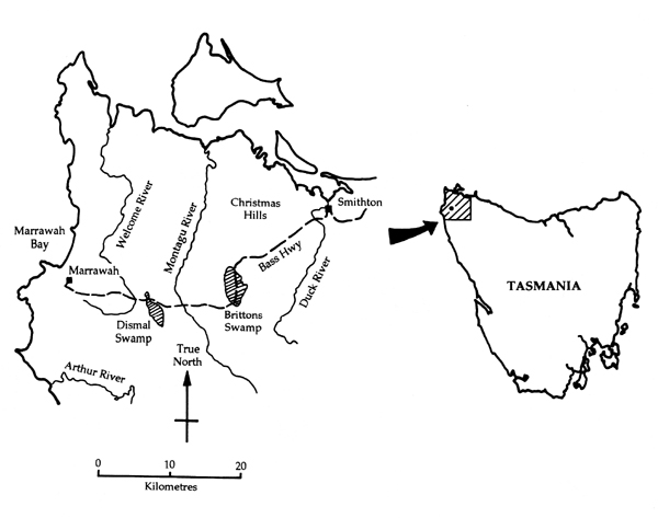
Figure 1: Locality map of Dismal Swamp
FORESTRY ACCEPTANCE
The topography, geology and hydrological behaviour of Dismal Swamp initially led Kiernan (1990b) to conclude that Dismal Swamp occupies a karst landform known as a polje. Poljes are defined and discussed in more detail elsewhere in this paper, but in essence are large flat-floored internally draining karst depressions of a type that is relatively rare in Australia. Kiernan argued that as a rare landform, and one of the few swamps in the Smithton region not yet altered by artificial drainage, conservation of the swamp - including retention of the forest cover - would be of nature conservation and also some practical benefit.
Since the management of Dismal Swamp for its conservation values would involve the application of special prescriptions and restrictions on forestry activities, the Tasmanian Forestry Commission opted to obtain a second opinion on its identification as a polje. To this end, Andy Spate of the NSW Parks and Wildlife Service was contracted as a consultant geomorphologist. Spate's fieldwork and resulting report (Spate 1990) supported Kiernan's earlier conclusion that Dismal Swamp was a polje, and probably of Australian significance as a landform type.
At this point the Forestry Commission accepted that the swamp is a polje, and a site of considerable conservation significance. The focus of attention then shifted, quite properly, from the swamp's identification as a polje to the problem of how to deal with the management issues arising from this recognition. Some discussion of the management issues is provided in a later section of this paper. In the event, however, no subsequent logging had actually been conducted at Dismal Swamp when a new political event brought a change in the land tenure status of much of the swamp which precluded future forestry activities there.
THE MINERS REACT
In November 1997, the Commonwealth and Tasmanian state governments signed the Tasmanian Regional Forest Agreement (RFA) whose purpose was to resolve the long-standing conflict between forestry and conservation in Tasmania. Amongst many other things, the RFA (Attachment 6) established a system of "Comprehensive, Adequate and Representative" (CAR) bioconservation reserves from which forestry was to be excluded in order to meet agreed-upon goals for the protection of biodiversity (specifically, forest communities), old growth forest and wilderness. There was no requirement for the conservation of geodiversity under the terms of the RFA. One of the reserves (CAR Reserve No. 14) encompassed 422 hectares of Dismal Swamp, adjoining a small Nature Reserve which already existed in the southeastern corner of the swamp, in order to protect a representative sample of a Blackwood (Acacia melanoxylon) swamp forest community. As one of the few areas of Blackwood swamp forest in northwest Tasmania which have not been artificially drained for agricultural purposes, Dismal Swamp was considered the most suitable sample available for conservation purposes.
Subsequent to the signing of the RFA, the Tasmanian Resource Planning and Development Commission (RPDC) was given the task of assigning appropriate reserve categories to certain of the new CAR reserves agreed upon under the RFA. In the case of many of the unresolved CAR reserves, including Dismal Swamp, the RFA stipulated that they must be assigned to a reserve category which permitted mineral exploration and mining (but not forestry) to occur. Under Tasmania's new reserve classification system, enacted by the state Regional Forest Agreement (Land Classification) Bill, 1998, mineral exploration and mining is permitted to be a management objective in several categories of conservation reserve, including Conservation Areas, certain Forest Reserves, Nature Recreation Areas, and Regional Reserves.
The RPDC conducted a public inquiry into the classification of the CAR reserves to which, out of 47 initial written submissions, none were made by mining companies, mining industry organisations or Mineral Resources Tasmania, and only a couple by individual geologists associated with the mining industry. After considering these public submissions, in August 1998 the RPDC published its proposed recommendations report (RPDC 1998b), in which it recommended Conservation Area status for a large number of CAR reserves including the Dismal Swamp reserve.
At this point representatives and members of the mining industry suddenly began to express concern about the proposed recommendations of the RPDC inquiry, belatedly indicating a preference for the Regional Reserve category as the most suitable CAR reserve category since they felt that, although the Conservation Area category allowed mining, it would be perceived as a less appropriate tenure for mining than the more neutrally - named Regional Reserve category. No mining industry representatives accepted responsibility for their failure to make earlier public submissions to the inquiry on this matter, and instead some parties appeared to imply that the mining industry had been deliberately excluded from the process. One geologist went so far as to state that, in not actively requesting mining or mineral exploration investors to contribute submissions: '...it could be suggested that the RPDC had more sinister motives in mind', and further that: 'It appears that the RPDC sees itself as above the RFA process. It chooses to 'pat the RFA process on the head' by saying "Nice little process; now, go away. We are here to represent the extreme green movement".' (Newnham 1998).
In response to the heated reaction from those associated with the mining industry in Tasmania, the RPDC convened a public hearing over two weeks in December 1998, which was attended by parties representing mining and conservation interests, and several government agencies. Having previously made submissions to the RPDC inquiry, I chose to register as a party to the hearings - fortuitously so since it turned out that certain mining representatives intended to use the hearing as an opportunity to discredit previous submissions to the inquiry from myself and some of my colleagues. The main submission in question (Dixon et al 1998) had pointed out (amongst many other things) that the Dismal Swamp CAR reserve had other conservation values in addition to its botanical values, namely that it was a polje, arguably one of the best examples in Australia, and that this fact should be taken into account in choosing an appropriate reserve category for the already - chosen CAR reserve.
The main attack on the credibility of the writer and his colleagues at the RPDC hearings was made by Dr Robin Morritt, Executive Director of Pacific - Nevada Mining Pty. Ltd., a Perth - based company with exploration licences and other interests in Tasmania. Morritt's written submission to the hearings (Morritt 1998) was supported by attachments from Professor Chris McA. Powell, Professor of Geology at the University of Western Australia (Powell 1998), and Dr Kenneth Snyder, Chief Geologist of Euro - Nevada Mining Corporation (Snyder 1998). Morritt's written submission also stated that a leading geomorphologist, Professor John Chappell (Research School of Earth Sciences, Australian National University) had been engaged to provide a report on Dismal Swamp, and that his results would be submitted to the hearing in due course (Morritt 1998, p7).
Morritt's submission stated that: "I examined the Dismal Swamp Reserve 14 because it lies within one of PN's licences and because of the high level "sensitivity" (4) assigned." (Morritt 1998, p6). Morritt and Snyder were under the erroneous (but highly flattering) impression that Dismal Swamp had been chosen as a CAR reserve on the strength of the evidence provided by Dixon et al (1998). Snyder (1998, p1) incorrectly stated: "The recommended status for CAR reserve adjoining Reserve 14 Conservation Area [sic] is largely based on recommendations made by Grant Dixon, Chris Sharples, and Ian Houshold in their January 1998 submission to the Commission." Would that we were so influential! Morritt (1998, p5-6) stated: "It can be demonstrated that the technical argument that led to a portion of this area being zoned as a Reserve is seriously flawed (refer to the attached Memorandum from Dr K. Snyder and the attached letter from Professor C. McA. Powell). Therefore, the case for zoning adjoining areas by using Reserve 14 as a basis for category-type [sic] is without basis. A sound case could now be mounted to demand the removal of Reserve 14 because its assignment is based on questionable science. The reports responsible for these submissions should now be discredited and disallowed as admissible evidence."
A first point to be noted at the outset is the fact that Morritt and his colleagues erroneously assumed that it was geoconservation - the significance of Dismal Swamp as a polje - which was responsible for the swamp becoming a CAR reserve, when in reality it was bioconservation - the importance of the Blackwood Swamp forest community - that was the actual cause. The apparent tendency of these geologists to see geoconservation as a more dangerous "enemy" than bioconservation, is an interesting quirk which is belied by the fact that bioconservation imperatives have seen vastly more land put into conservation reserves than geoconservation ever has or is ever likely to. It also reflects on the poor understanding of the RFA process which the miners had.
The remainder of this section examines the arguments used by Morritt, Snyder and Powell in their attempt to discredit my colleagues and I by "proving" that Dismal Swamp cannot be a polje, as we had stated it to be in our earlier submission (Dixon et al 1998). Although it may seem self - indulgent, I have chosen to discuss the arguments used in some detail so as to underline and document the extraordinary nature of the attack that certain miners felt was appropriate to launch against our credibility and against the concept of geoconservation.
Our previous assertion that Dismal Swamp was a polje had been a citation from Kevin Kiernan's "Atlas of Tasmanian Karst" (Kiernan 1995, Vol. 1, p116-118), and the arguments presented by Morritt, Snyder and Powell were also merely a 'desktop' critique of Kiernan's writing on the subject. However, given that Morritt et al chose to attempt to refute Kiernan's (fieldwork-based) conclusions, it is interesting that they failed to provide any evidence of having undertaken new fieldwork in support of their critique.
Even more interesting is the fact that, at Morritt's request, Professor John Chappell did examine the field evidence, and then presented Morritt with a report which Morritt subsequently failed to release to the RPDC, despite have earlier stated in writing that he would do so (Morritt 1998, p. 7). In response to a letter to Morritt from myself, Morritt stated that "Submissions of further expert opinion at this time will, in our view, not benefit the Commissioners." Nevertheless, Morritt offered to make the report available to me upon receipt of a cheque for $5,000 (Letter from R. Morritt to C. Sharples, 17 Feb. 1999). This for a report Morritt had previously stated would be submitted - presumably without charge - to the RPDC public inquiry! Whilst I have consequently never sighted Professor Chappell's report to Morritt, during later fieldwork in May 1999 Professor Chappell stated to me that he considered the field evidence supported the view that Dismal Swamp is most likely a polje...
Morritt
Morritt's written and verbal submissions to the December 1998 RPDC hearing on the subject of Dismal Swamp relied largely on the written attachments by Powell and Snyder (discussed below). However, he did verbally present one extra piece of evidence to the hearing, in that he displayed an airphoto of Dismal Swamp on which he maintained one could discern streams flowing down the eastern rim of the swamp, across the centre of the swamp floor, and out through a gap in the western rim, thereby 'proving' that the swamp was not an internally draining feature. Scrutiny of the airphoto by the writer failed to reveal anything more than some vague vegetation boundaries in the indicated parts of the swamp floor, and certainly no obvious stream courses. Under cross-examination by the writer Morritt acknowledged that he had not examined the purported watercourses in the field. The writer, together with Ian Houshold, Professor John Chappell and others, subsequently did examine the streams flowing down the eastern rim of the swamp during fieldwork on 7th May 1999, and confirmed that each stream, upon reaching the swamp floor, disperses into minor distributary channels which then merge with the swamp as a whole. There is no field evidence for discrete stream courses crossing the swamp from east to west, as claimed by Morritt.
Morritt, who presented the RPDC Commissioners with no evidence of previous experience in karst geomorphology, also maintained during the hearings that, although the floor of Dismal Swamp was developed in carbonate rock, it could not be a karst feature because it is flanked by a rim of a non-carbonate rock, namely siltstone. This amusing 'evidence' amply demonstrated Morritt's lack of knowledge about matters karstic; I am sure I do not need to remind readers familiar with subjacent karst landforms that, provided the main depression has formed through karst solution processes, the feature is by definition a karst landform and the composition of the rim is quite irrelevant! In fact, large karst depressions flanked by non-carbonate rocks are a recognised type of polje, known as a 'border polje' (Gams 1978, p176-177, Fig. 1; Ford & Williams 1989, p429, 431), and Kiernan (1995 Vol. 1, p118) had in fact stated that Dismal Swamp was a border polje for this very reason.
Snyder
Morritt presented the RPDC hearing with further evidence regarding Dismal Swamp in the form of a written attachment by Dr Ken Snyder (Snyder 1998). Morritt (1998, p7, 15) implied that Snyder had some experience in karst studies, having in 1982 published a paper on barite and base metal deposits in Cambrian-age karst features; however this hardly consitutes a thorough grounding in present-day surface and near-surface karst processes! Snyder similarly provided no evidence of having examined Dismal Swamp in the field.
In referring to a sinkhole surveyed within Dismal Swamp in 1944, which Kiernan (1995, p. 117) cited as evidence of karstic drainage, Snyder (1998, p. 2) attempted to argue that the existence of the sinkhole is unproven, being based entirely on an old surveyors plan, and was therefore inadmissable as evidence. However, not only is there no apparent reason to doubt the surveyor's plan, but the sinkhole was in any case visited by Professor John Chappell in December 1998, by Ian Houshold and Chris Sharples on 14th March 1999, and again by Professor John Chappell, Rolan Eberhard and others on 7th May 1999. The sinkhole indeed exists, it is located where the 1944 surveyors map indicates, and it is a classic conical sinkhole approximately 30m diameter and 4.3m deep. Worse still, it lies no more than 15 minutes walk from the nearby Bass Highway. Snyder's failure to test the existence of this sinkhole by fieldwork does his argument no credit (the significance of the sinkhole is discussed later in this paper).
It is of course possible that one could search for the sinkhole and fail to find it due to poor long-distance visibility in the forest. However, even more telling evidence of Snyder's failure to properly check his arguments is provided by his statement, that:
"As was clearly stated in the paper by Gams, a polje displays steep peripheral slopes as evidence of carbonate dissolution. The total lack of steep peripheral slopes at Dismal Swamp should also have been noted by Kiernan as evidence that karstic processes are not a significant factor in the geology of the area." (Snyder 1998, p5)
Although it is not even an essential diagnostic criterion of a polje, Dismal Swamp does in fact display steep slopes along a large proportion of its periphery. A cursory examination of the Marrawah 1:25,000 topographic map sheet (Sheet 3046, published 1988) clearly shows very steep slopes along the southwest periphery of the swamp, which the writer has personally measured as having slope angles of 35° - 37° (i.e., 'very steep' by any reasonable standard; see Bell 1998, p14). The writer also has measured 35° slopes along the eastern periphery of the swamp, and similar slopes occur along the western side of the swamp and - most interestingly - immediately below the Bass Highway lookout near the northern end of the swamp. In this context, Snyder's claim that there is a "total lack" of steep peripheral slopes at Dismal Swamp is a good measure of the quality of his scientific argument.
It would be tedious to review the remainder of Snyder's arguments, which in the writer's opinion similarly fail to inspire confidence in his understanding of karst geomorphology.
Powell
It is important to examine Professor Chris McA. Powell's evidence to the RPDC hearings in a little more detail, since his position as a Professor of Geology at a respected institution raises the expectation that his evidence will carry considerable weight on the strength of his academic credentials. Powell is a Professor of Geology at the University of Western Australia and is a well recognised expert on structural geology and tectonics. However, he provided no evidence to the RPDC hearing of significant experience in karst geomorphology, although Morritt stated in his submission (Morritt 1998, p. 6) that Professor Powell had published articles on carbonate rocks in the Devonian Lennard Shelf of Western Australia. However, studying the sedimentology, stratigraphy, structure or other bedrock characteristics of a limestone body provides information on only one aspect of the issues involved in karst processes, and certainly does not make one a karst geomorphologist. Despite this apparent lack of professional experience in karst per se, Professor Powell was presented to the RPDC hearing as an expert witness with appropriate expertise to evaluate the origin of Dismal Swamp (Morritt 1998, p6). Professor Powell submitted both written evidence (Powell 1998) and verbal evidence (December 1st 1998) to the RPDC hearings. The writer cross-examined Powell at the hearings, and the following account is based on both Powell's written and verbal evidence, the latter having been tape recorded by the RPDC.
Powell's evidence to the hearings not only dealt with the Dismal Swamp polje, but also included a "review" of a paper on an aspect of geoconservation, co-authored by the writer and others (Houshold et al 1997). Since this was in my opinion part of an attempt to discredit the concept of geoconservation generally, I deal with this issue first below.
Georegionalisation Paper
The paper critiqued by Powell is one by Ian Houshold, Chris Sharples, Grant Dixon and Nathan Duhig entitled " Georegionalisation - A more systematic approach for the identification of places of geoconservation significance" (Houshold et al 1997). Powell disparagingly referred to this as an 'internal report' (Powell 1998, p3), although it was in fact published for public distribution in the proceedings of a workshop held by the Australian Heritage Commission in Canberra. In essence, the theme of this paper is based on a widely used principle of nature conservation management, namely that land managers should endeavour to identify and conserve representative samples of all the major aspects or variants of the type of natural system under consideration in any given case. The CAR reserves which were the subject of the RPDC hearings are themselves a good example of the application of this principle, since one of their stated purposes was to protect "Comprehensive, Adequate and Representative" (CAR) samples of Tasmania's major natural forest communities. The concept of "Georegionalisation" presented by Houshold et al (1997) is a proposed method for applying the same principle to geoconservation, by systematically identifying distinctive regions in which major representative examples of the most important categories of geological, geomorphological and soil phenomena defined by a geodiversity classification scheme will be found.
The most interesting aspect of Powell's review of Houshold et al. (1997) is that Powell nowhere addresses the central theme of the paper, namely georegionalisation, but instead simply finds fault with various incidental statements scattered through the paper. Powell's failure to address the central and dominant theme of the paper strongly suggests, in my opinion, that he did not have the appropriate expertise to do so (namely, experience in nature conservation and land management, with an understanding of their basic principles).
Nonetheless, Powell's review did address one fundamental general principle in geoconservation, but in doing so betrayed a deep misunderstanding of that principle. Powell makes the following statement:
"There is a fundamental assumption underpinning the whole article, expressed on p71, where it is stated that "...a fundamental aim of geoconservation is maintenance of the rates and magnitudes of natural processes of change (including erosion)" (authors' italics). This is a ludicrous statement, because if Earth History has taught us anything it is that the Earth is in a constant state of change, including changes in rates of natural processes. The philosophy expressed here is similar to that used by King Canute of ancient Danish legend, who felt so confident of his authority, and understood so little of nature, that he commanded the tide not to come in. No modern scientist should have such Canutian delusions! To the contrary, it is precisely because there have been changes in the past, some very recent, that we have the variety of landforms to enjoy. The Earth is not fixed, it is in a continuous state of change, and any attempts by "Geoconservationists" to stop the processes are misguided." Powell 1998, p3-4)
The idea of maintaining natural rates and magnitudes of change has been outlined earlier in this paper, and in any case I believe it is quite clear from our quoted statement above that the intent is that we should endeavour to allow natural changes to continue to occur; indeed, our quoted words can be simply paraphrased as maintenance....of change. The intent of our statement is that geoconservation should endeavour to maintain natural rates and magnitudes of change, as opposed to allowing artificially accelerated changes to occur (e.g., artificially triggered landslips, karst subsidence, unsustainable groundwater drawdown, etc). Now, I am prepared to concede that the wording of our statement can - to a very unsympathetic and nitpickingly pedantic eye - be interpreted as implying that we should not allow natural rates of change to themselves change naturally; and so perhaps we need to work some more on the formulation of our words! (The formulation used in the present paper (see earlier) is simply maintenance of natural rates and magnitudes of change). However I nevertheless consider that Powell's is a quite unfair interpretation of our words, especially when it is then used as justification for comparing us to King Canute, implying that we cannot be 'modern scientists' if we hold such ideas, and suggesting that we want to "stop the processes".
In fact, Powell's quote from our text is merely the second half of a sentence whose first half, not quoted by Powell, provides a context which makes it very difficult to accuse us of wanting to "stop the processes", as Powell has done. Quoted in full, the sentence from which Powell provided only a partial quote reads:
"In some cases, allowing a relict landform or palaeosol to be destroyed by natural erosion may be justified, on the grounds that a fundamental aim of geoconservation is maintenance of the rates and magnitudes of natural processes of change (including erosion)." (Houshold et al, 1997, p71)
The clear implication of this sentence, taken as a whole, is that it may in some circumstances be more preferable to allow natural changes to destroy features of geoconservation significance, than it would be to preserve those features by halting a natural process of change.
It is rather disturbing that Powell chose to interpret our words as implying that we advocate stopping natural processes of change, when taken in context our words clearly mean the opposite. I am left wondering whether Powell's interpretation of our words was unduly influenced by an ill-informed prejudice sometimes encountered amongst geologists, namely a belief that conservationists in general wish to hold the Earth in some kind of static museum-like state?
Dismal Swamp Polje
Turning to Powell's critique of the Dismal Swamp issue, the first noteworthy point is that he demonstrates a fundamental confusion by stating: "In summary, it is my opinion that the origin of the Dismal Swamp as a "polje" is not established, and a far more likely origin is that it is simply the erosional expression of a breached anticline, with little, if any, significance for conservation purposes." (Powell 1998, p1). The confusion lies in the fact that his wording suggests he sees poljes and breached anticlines as two mutually exclusive phenomena. In fact, there is little doubt that Dismal Swamp does indeed lie in a breached anticline; however that does not in any way exclude the possibility of it being also a polje. Indeed, it is the breach in the crest of the anticline that has allowed the carbonate rocks to be the uppermost bedrock unit exposed there (see later). Hence, the breached anticline is simply the structural context in which the polje landform has developed. All landforms develop in some sort of structural context, and a breached anticline is a very fine context for a polje to be developed in!
The quality of Powell's investigation of Dismal Swamp was admirably demonstrated during his verbal evidence to the RPDC hearings, when he displayed a map, copied from the Woolnorth geological map sheet (Seymour & Baillie 1992), on which he identified a highlighted area as being the dolomite-floored basin of Dismal Swamp. Unfortunately, the area which Powell repeatedly pointed out as being Dismal Swamp is actually a very well-drained area of Late Precambrian tholeiitic basalt on the crest of Bond Tier, above and to the east of Dismal Swamp. Powell appears not to have noticed either the topographic form of the ridgetop (cleared indicated by the map contours) or its lithological type (clearly displayed on the map key), and it was only when the writer pointed the error out while cross-examining Powell that he recognised and acknowledged his mistake. Powell's simple error was an unexpected and quite startling one for a Professor of Geology to have made, and underscores the obviously hasty and superficial nature of his critique of the Dismal Swamp issue.
Despite this glaring gaffe, in his written submission Powell showed some caution in that rather than stating outright that Dismal Swamp is not a polje, he instead merely argued that its identity had not been proven. However, his argument behind this assertion is, if anything, even more disturbing than his map error:
The core of Powell's argument appears on page 5 of his submission, where he refers to Kevin Kiernan's (1995, Vol. 1, p116-118) description of Dismal Swamp as follows:
"Further reading of his description shows that "...the bedrock of the floor of the swamp is unconfirmed" and that "...if it is formed in the Black River Dolomite [sic]7 correlate then no potential [my emphasis8] seems to exist for the necessary subsurface evacuation [my emphasis] of dissolved carbonate." If this is true, then Dismal Swamp is not a polje, a point conceded by Kiernan (1995, p117) where he wrote "...The possibility that the Dismal Swamp is karstic and that the basin was actually a polje". (Powell 1998, p5)
Given that Kiernan's discussion in fact goes on to argue that Dismal Swamp most probably is a polje, it is mind-boggling to imagine how Kiernan - a trained geomorphologist - could have logically reached such a conclusion if he had truly thought - as Powell's quote suggests - that "no potential seems to exist for the necessary subsurface evacuation of dissolved carbonate". However, the key to this conundrum is simple: Powell's quote is a partial one which gives a severely distorted impression of Kiernan's meaning. Although Powell ended his quote after the word "carbonate" with a full stop, that was not in fact the end of Kiernan's sentence, and Powell should have used the conventional "..." to indicate this fact. Quoted in full, Kiernan's sentence actually reads as follows:
"Hence, the floor of Dismal Swamp could be formed in either of these dolomite units 9, but if it is formed in the Black River correlate then no potential seems to exist for the necessary subsurface evacuation of dissolved carbonate via interstratal karst beneath the greywacke although it may still have been able to escape to the NNW or SSE along the strike of the dolomite." (Kiernan 1995, vol. 1, p116)
7sic - The word "dolomite" did not in fact appear here in Kiernan's text
8Powell's emphasis.
9the Smithton or Black River Dolomites; C.S.
It is quite clear from the last part of this sentence - not quoted by Powell - that Kiernan was not saying that there is no potential for subsurface evacuation; he was merely stating that whilst one evacuation pathway was probably not possible, another was (depending upon what carbonate rock unit was involved). It is difficult to understand how Powell could have failed to grasp the meaning of the last part of Kiernan's sentence.
Powell's creative interpretation of Kiernan's writing continues with his claim (quoted above) that Kiernan had "conceded" the possibility that Dismal Swamp was not a polje when he wrote: "The possibility that the Dismal Swamp is karstic and that the basin was actually a polje..." (Powell's emphasis). In fact, Kiernan wrote this sentence in the course of describing the history of the recognition of the swamp as a polje; that is, Kiernan was referring to the fact that he first recognised the possibility of it being a polje, after which he then described the further investigation by Andy Spate which concurred with his interpretation that it is a polje.
In relation to this latter investigation, Powell's submission again provides a misleading reading of Kiernan's writing. Powell states:
"Further on, Kiernan (1995, p117) reports that an "...independent consultant commissioned by the Smithton District Office of the Forestry Commission ... concluded that although the origin of the Dismal Swamp has not yet been conclusively demonstrated, the form, local geological structure and lithology leads inescapably to the conclusion that it is a polje"[my emphasis]. What kind of scientific reasoning is this? On the one hand, the consultant admits that the origin of the Dismal Swamp is unknown, but on the other hand he already knows the answer (inescapable conclusion)! It speaks of prejudgement of the issues, and, in other circles (e.g., the case of the enthusiastic but discredited Dr McBride of Foundation 41 in Sydney, with his infamous phantom extra rabbit added to support his prejudice about the dangers of Debendox), could be regarded as fraudulent." (Powell 1998, p. 5 - 6)
Unfortunately, Powell has here again neglected to mention the crucial reason for the consultant's "inescapable conclusion", namely that although the origin of Dismal Swamp had not yet been conclusively demonstrated "Spate concluded that none of the other possible mechanisms for its formation fits the available evidence." (Kiernan 1995, Vol. 1, p. 117). In other words, Spate was quite properly taking the Popperian view that, whilst he could not absolutely prove beyond all conceivable doubt that Dismal Swamp was a polje, he had falsified all other possibilities and the explanation that the swamp is a polje was the only one left that fitted the evidence.
Having presented his argument as described above, Powell states:
"Somehow, between Kiernan's initial report and the citation in the submission to this commission, a possibility has become an established fact, and the quality of the feature has been raised to an Outstanding example on a National scale! Not only has the origin of the Dismal Swamp not been established, but the quality of the features which might be there if it were a polje has not been documented. I view this kind of reporting as misleading and, if done deliberately, dishonest." (Powell 1998, p. 6)
The reasons for attributing high significance to the Dismal Swamp were in fact discussed by Kiernan (1995, Vol. 1, p118), and are noted elsewhere in the present paper. In view of the nature and quality of Powell's own arguments, I believe that the final sentence quoted from Powell above is highly insulting towards my colleagues and I, although I note that Powell was sufficiently canny as to phrase the sentence in a conditional form so as to avoid directly defaming us. Nonetheless, his implication is clear, and I believe he owes us an apology (although I do not expect to receive one!).
As crude and amateurish as Professor Powell's evidence to the RPDC hearings may seem on the surface, it raises serious issues of academic ethics. In the first place, Powell presented himself as an expert witness to provide evidence to a statutory public hearing - held by a government Commission charged with important decision-making responsibilities - on topics (geoconservation and karst geomorphology) which he provided no evidence of having prior professional experience in. Secondly, the key part of Powell's evidence was constructed not on the basis of his own scientific observations, but rather relies on the use of partial quotes from previously published work; quotes which very clearly give a misleading impression of the intent of the author of the quoted text. Moreover, it is obvious that his arguments were hastily constructed, since Powell failed to even locate Dismal Swamp correctly on a map. Yet, on the basis of this type of argument, he was prepared to denounce the writer and his colleagues in scathing prose which carried a clear implication that we may be guilty of fraud.
In my opinion, it is clear that Powell was relying on his academic prestige and credentials - rather than any serious scientific evaluation of the evidence - to convince the RPDC Commissioners that the writer and his colleagues were scientifically incompetent. His arguments consist mainly of insulting rhetoric and partial quotes which give a misleading impression of the quoted writer's clear intent. Coming from a Professor at a respected institution, in my opinion such behaviour raises ethical questions about Powell's fitness to enjoy the prestige of his academic position. As a professor, Powell has a responsibility to uphold high standards of scientific inquiry. More generally, Powell's behaviour is in my opinion similar to a disturbing trend amongst some - but thankfully not all - scientists to lend their prestige and scientific credentials to the support of controversial corporate agendas by presenting interpretations of scientific data biased - or "spun" - to suit their corporate master's interests (see for example Beder 1997, Siano 1999, Rampton & Stauber 1999).
THE DISMAL SWAMP POLJE
The following sections review the scientific evidence for the identification of Dismal Swamp as a polje.
WHAT IS A POLJE?
Any classification of objects or processes - for example, the identification of "karst" as a distinctive type of landforming process, and of "poljes" as a distinctive type of karst landform - is an artificial human ordering or grouping of natural things. Despite what Plato would have asserted, there is no perfect "form of the polje" residing in some sort of metaphysical hyperspace, against which any landform claimed to be a polje must be compared. Rather, a polje is precisely and simply that which a consensus of relevant expert opinion defines it to be>10. Gams (1978) has provided a seminal study of poljes in which he set out to define the "polje" by identifying what features or landform characteristics are those most widely held to characterise or define poljes. His study was reviewed and slightly modified by Ford & Williams (1989, p428-432).
The term "polje" was originally applied to landforms in the Dinaric karst of Yugoslavia, and is a slavic word meaning "field". The term has been applied to flat alluviated plains formed by non-karstic processes (e.g., see Sweeting 1972, p. 192), but the term has acquired a technical meaning in karst geomorphology, and it is the later meaning which is discussed here. In essence, poljes are 'large flat-floored enclosed depressions in karst terrains' (Ford & Williams 1989, p. 428). In general, they are the largest scale of enclosed karst depressions involving the input or throughput of water. A crucial characteristic of all poljes is that they have developed close to the local water table (Ford & Williams 1978, p. 429), giving rise to lateral corrosion and consequent development of a broad planar valley floor rather than a deep incised one (ibid p. 431, Sweeting 1972, p. 198).
However, subsequent events (e.g., uplift, changes in the water table level) may subsequently separate the polje floor from the water table and can result in terracing or other changes to the polje morphology. The process of lateral planation of the polje floor results in a tendency towards undercutting and thus oversteepening of the polje margins, producing characteristic steep peripheral slopes (although these are not regarded by all geomorphologists as an essential criterion of a polje). Polje floors may be mantled with alluvial sediments, which may partly seal the underlying karstic bedrock causing flooding and surface overflow from the depression during wetter periods (Sweeting 1972, p.199, Ford & Williams 1989, p. 431).
10An apparently fundamental distinction exists between the criteria used to classify biodiversity and geodiversity (Kiernan 1997, I. Houshold pers. comm.). Biologists can define and classify the elements of biodiversity (e.g. species) by reference to universal characteristics of living things; for example, individuals can be classified as belonging to a given species if they can reproduce with other members of the species to produce viable offspring. In contrast, defining the divisions between elements of geodiversity is more difficult since we have not identified similarly universal criteria for distinguishing between the different elements of the non-living world.
Gams (1978, p. 178) and Ford & Williams (1989, p428 - 429) identified three criteria which a depression must meet to be classified as a polje. These are:
- Flat floor (which can also be terraced) in rock or in unconsolidated sediments such as alluvium;
- A closed basin with a steeply rising marginal slope at least on one side; and
- Karstic drainage.
These workers also note that poljes are large enclosed depressions (great karst basins in Gams' words); however the minimum size limit is arbitrary, although Gams (1978, p. 179) cited a width of 400m as a lower limit for the width of the flat floor of a polje.
IS DISMAL SWAMP A POLJE?
Geological and Geomorphic Context
Structure and stratigraphy
Dismal Swamp is situated in the western part of a large folded structure known as the Smithton Synclinorium, which is generally characterised by open, upright fold structures with roughly north-south trending axes (Seymour & Calver 1995). Folding in the Smithton Synclinorium is thought to have occurred during the Cambrian Tyennan Orogeny (circa 500 ±10ma)11, although further middle Devonian folding related to the Tabberabberan Orogeny may have overprinted the Cambrian structures (Seymour & Calver 1995, Turner et al. 1998).
Regional geological mapping (Seymour & Baillie 1992) shows that Dismal Swamp occupies the erosionally - breached axis of a NNW - SSE trending anticline within the Smithton Synclinorium (see Figure 2). The low ridges surrounding the swamp, forming part of the anticlinal limbs of the structure, are composed of lithic conglomerates, greywackes, siltstones and tholeiitic basalts assigned to the Kanunnah Subgroup 12 of the Late Precambrian Togari Group (Everard et al. 1996). Stratigraphic sections through the Togari Group elsewhere in the Smithton Synclinorium show that the Kanunnah Subgroup is underlain by a carbonate unit, the Black River Dolomite, and overlain by another carbonate unit, the Smithton Dolomite (Seymour & Baillie 1992, Calver & Everard 1992, Everard et al. 1996). The Black River Dolomite is discontinuously underlain by the Forest Conglomerate, and both units are unconformably or disconformably underlain by older Precambrian clastic rocks of the Rocky Cape Group. The Smithton Dolomite outcrops in swamps east and west of the ridges surrounding Dismal Swamp as would be expected from the broad anticlinal structure (see Figure 2), and the known regional structure and stratigraphy similarly implies that the flat floor of Dismal Swamp itself is probably underlain by the Black River Dolomite.
Although no unaltered dolomite has been observed outcropping or is known to have been drilled at Dismal Swamp, silicified dolomite outcrops on the southeastern part of the swamp floor and is probably a silicified portion of the Black River Dolomite (see below). Seymour & Baillie (1992) indicate that the Black River Dolomite is typically about 250m thick in the western part of the Smithton Synclinorium, providing ample thickness for the development of extensive karst drainage systems. Detailed mapping of the Togari Group type section, along the Arthur River south of Dismal Swamp, shows that the Black River Dolomite typically comprises dolomitic breccias, stromatolitic dolomites, and interbedded dolomites, cherts (commonly silicified dolomite), siltstones and mudstones (Calver & Everard 1992, Everard et al. 1996). Away from such near - continuous exposures of the stratigraphy, the more dolomitic parts of the unit tend to be recessive in the landscape, with surface outcrop predominantly comprising the more resistant clastic and cherty horizons. The situation at Dismal Swamp appears to be typical of this pattern.
11 Formerly known as the Penguin Orogeny; see Turner et al. (1998).
12 Formerly referred to as the Crimson Creek Formation correlate, e.g. by Seymour & Baillie 1992.
Geomorphic setting
The ridges surrounding Dismal Swamp, Hays and Bond Tiers, display dissected flat to undulating tops at roughly 80 - 90m above sea level (ASL), and further east at Christmas Hills ridges of folded clastic rocks display similar dissected flat tops at roughly 80 - 110m ASL. These flat tops are planed off across moderately to steeply dipping bedrock structures, and are evidently concordant remanent fragments of a gently sloping erosion surface known as the Lower Coastal Surface (Davies 1959). The presence of Tertiary (Miocene?) basalt containing limestone fragments of probable Lower to Middle Miocene age at Brittons Swamp, a depression incised into the erosion surface about 10 km east of Dismal Swamp (Gill & Banks 1956, Seymour & Baillie 1992), suggest that the erosion surface is unlikely to be younger than circa 16.5 ma, and indeed other evidence from the Arthur - Pieman Rivers region, further south, suggests that the planation and then uplift and incision of the Lower Coastal Surface probably predates Late Eocene - Early Oligocene times, circa 36 ma (Houshold et al. 1999). Since the Dismal Swamp basin is incised below the erosion surface, these dates imply that it has had at least 16.5, and probably over 36 million years in which to develop.
Dismal Swamp lies within one of the most extensive karst terrains in Tasmania: between Smithton and Marrawah, low-lying flat karst corrosion plains at 0 - 60m above sea level extend for tens of kilometres across the folded carbonate units of the Togari Group in the valleys of the Duck, Montagu, Welcome and other rivers, and are separated by residual ridges composed of interbedded clastic rock units. Prior to being drained for agricultural purposes most of these plains were swampy, with the water table lying at or near the surface. Only a relatively small number of sinkholes and caves are known, mostly in residual hilly areas of dolomite as at Montague, Redpa and Julius River (Kiernan et al. 1991, Kiernan 1995). However, the lowering of sea level by over 100m during Cainozoic glacial climatic phases would have substantially lowered the regional base levels, providing significant hydraulic gradients beneath the karst plains and so probably facilitating accelerated development of underground karst drainage systems at those times (Kiernan 1990b). The earliest evidence of a phase of Cainozoic glaciation in Tasmania is a possible till of Early Oligocene age (circa 36 ma) in the Lemonthyme valley of northern Tasmania (Macphail et al. 1993), and multiple glaciations in Tasmania have been demonstrated for Quaternary times (Kiernan 1983).
Conversely, fossiliferous marine sediments of Last Interglacial age (circa 125,000 years BP), known as the Mella Sand, occur at up to 20m above present sea level in the Smithton area (Gill & Banks 1956, Murray-Wallace & Goede 1991). These Last Interglacial shorelines are considerably higher than their equivalents around much of mainland Australia (Murray - Wallace & Belperio 1991), indicating that Tasmania has been uplifted relative to much of mainland Australia since the Last Interglacial. Since the floor of Dismal Swamp lies at about 42m ASL, it was probably above the range of Last Interglacial marine activity; however the age of onset of neotectonic uplift in Tasmania is unknown and marine sediments at 49m and 71m ASL in northeastern Tasmania may have been deposited during preceding interglacial stages, implying uplift prior to the Last Interglacial (Bowden & Colhoun 1984). If this is the case, then Dismal Swamp could have been within the range of marine processes during middle Pleistocene interglacial stages.
Aeolian sands of Last Glacial age commonly overlie Last Interglacial marine sediments in the far northwestern region of Tasmania (Gill & Banks 1956, van de Geer et al. 1986, Murray - Wallace & Goede 1991). Given the generally sparse vegetation cover and windier conditions in Tasmania during the Last Glacial stage (Bowden 1983), Last Glacial aeolian sands could have been deposited in the Dismal Swamp area. Field reconnaissance suggests this is the case (see later).
In summary, we can infer that processes leading to the development of a polje at Dismal Swamp could have commenced prior to 16.5 ma (and probably prior to 36 ma) when uplift of the Lower Coastal Surface allowed fluvial processes to incise below that surface, eventually exposing the Black River Dolomite along the breached axis of an anticline. Underground karst drainage development would have been accelerated during times of lowered base levels during Cainozoic glacial stages, although the lateral karstic corrosion required to form a characteristic flat polje floor may require interglacial conditions to provide the necessary higher water tables related to higher base levels.
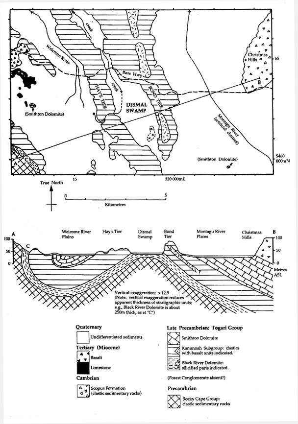
Figure 2: Geological plan and cross-section of Dismal Swamp (adapted from Seymour & Baillie 1992).
The Criteria to be satisfied:
Given the geological and geomorphic context of Dismal Swamp as described above, the necessary conditions for a polje to have developed there have clearly existed. The following sections examine the available field evidence to determine whether Dismal Swamp does indeed satisfy the criteria for a polje. The evidence described below is based both upon previous work as cited, and on evidence obtained during field visits by the writer and Ian Houshold on 14th - 15th March 1999, and on 7th May 1999 by the same workers together with Professor John Chappell and others.
The criteria for Dismal Swamp to be identified as a polje can be listed as follows (based on the criteria defined by Gams (1978) and Ford & Williams (1989), as noted above):
- flat floor in rock or unconsolidated sediments;
- flat floor at least 400m wide;
- a closed basin;
- steeply rising marginal slope at least on one side; and
- karstic drainage.
The following discussion identifies the degree to which Dismal Swamp complies with each of these criteria.
Flat floor in rock or unconsolidated sediments.
A flat floor is an essential characteristic of a polje, since it results directly from the fact that poljes develop by lateral corrosion at the local water table. However, Gams (1978, p179) notes that it is not necessary for the entire polje floor to be flat since the lateral corrosion process may have been interrupted by other processes, resulting in terracing or incomplete planation of the floor.
The floor of Dismal Swamp is very flat, more so indeed than many of the classic Dinaric poljes described by Gams (1978). A dumpy level survey by the writer and I. Houshold showed that the long profile of the creek channel draining from the western side of Dismal Swamp (see Fig. 3) is almost perfectly flat (to within 0.2m) over a distance of about 400m upstream into the swamp from the western swamp margin at grid ref. 316 900mE 5462 330mN. From the upstream terminus of the survey, a foot traverse across the swamp floor in a northeasterly direction revealed no discernable relief apart from surface irregularities of a few centimetres amplitude until the opposite swamp margin slope was reached. The Marrawah 1:25,000 topographic map (sheet 3046, 1988) shows only three surveyed spot heights on the swamp floor, at 41, 42 and 42 metres above sea level, indicating a very flat floor. The only notable relief shown on the latter map is a small rise in the southeast corner of the swamp which breaks the 50m ASL contour; this is part of an area of resistant silicified dolomite outcrop (described further below). Apart from the latter low rise, it appears that most of the swamp floor has no more than 1 or 2 metres relief, lying around the 41 - 42 m ASL level.
Soils and sediments
Apart from the low silicified dolomite outcrops mentioned above, no other bedrock outcrop is known on the swamp floor. The flat swamp floor comprises mostly mottled grey silty clays of unknown depth with little peaty organic topsoil. The relative lack of organic soil materials was also noted by Spate (1990) and is unusual for a swampy environment. The ability of the swamp to drain almost dry in summer - probably due to karst drainage as argued in this paper - may create more aerobic topsoil conditions than is usual in swamps, thereby allowing relatively rapid decay of organic material and inhibiting peat accumulation. The mottled clays are similarly indicative of periodic water table lowering.
In the western and northern parts of the swamp floor the clayey subsoils are commonly overlain by a few centimetres of fine sandy topsoil (e.g., around 317 200mE 5462 500mN) which appears to be absent in the central part of the swamp, and may represent aeolian sands deposited during the last glacial climatic stage (J. Chappell pers. comm.). Pebbles and granules of mudstone or siltstone noted in some swamp topsoils (e.g., in the northern part of the swamp floor) are probably derived from clastic Kanunnah Subgroup rocks on the adjacent marginal slopes, indicating that the swamp soils include at least a component of allogenic alluvial sediments. Insoluble weathering products from the dolomite sequence are also likely to comprise a proportion of the swamp soil parent material. In strong contrast to the swamp floor soils, the surrounding marginal slopes are typically mantled by silty red-brown soils developed on colluvium derived from Kanunnah Subgroup mudstones and siltstones.
Flat floor at least 400m wide.
As noted previously, the minimum size limit of 400m width for a polje floor is an arbitrary figure. Nonetheless Dismal Swamp easily exceeds this figure: the flat swamp floor measures about 4 km NNW to SSE, and ranges from about 1 km to 2 km wide east to west. Even if the western part of the swamp floor - which drains to the west via a surface stream for part of the year - is excluded, the internally - draining central and eastern part of the swamp still measures about 2.5 km north to south and 0.4 km to 1.0 km wide west to east. Dismal Swamp easily exceeds the minimum size criterion for a polje.
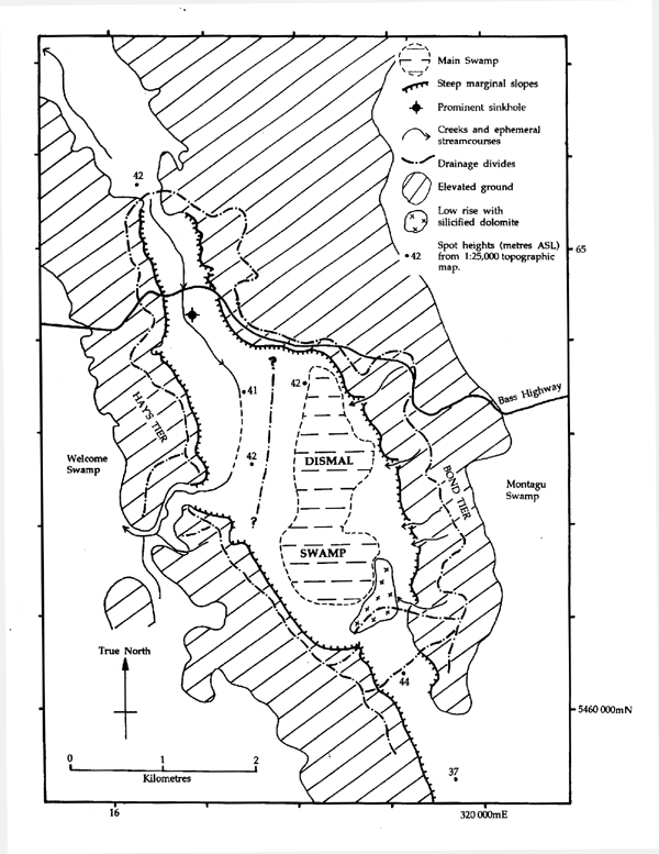
Figure 3: Map of Dismal Swamp, illustrating important geomorphic features.
A closed basin.
The 1:25,000 topographic map (Marrawah sheet 3046) clearly shows that the basin of Dismal Swamp is enclosed by a rim of steep marginal slopes about 20 - 40 m high on all sides apart from three short low points in the rim where the map contour interval of 10m is insufficient to demonstrate closure. These low points occur at the NNW, SSE and western sides of the swamp basin (see Figure 3).
The NNW low point takes the form of a flat-floored valley or corridor about 200 - 400m wide extending NNW from the main swamp basin, and is crossed by the Bass Highway (see Fig. 3). An ephemeral drainage line is evident in the thalweg of this valley near the Bass Highway crossing. A dumpy level survey along this drainage line by the writer and I. Houshold demonstrated that it descends very gently southwards from the highway into the main swamp basin (by less than 0.5m over a distance of about 300m). However, two km NNW of the Bass Highway crossing, streams in the same valley drain northwards away from the swamp (Marrawah 1:25,000 topographic map), demonstrating that the swamp basin is topographically closed at the NNW low point of its rim. The surface drainage divide appears to lie about 1 km north of the Bass Highway, at around 316 400mE 5465 600mN.
The SSE low point of the rim appears to be about 600m wide on the topographic map; however much of this interval actually comprises a distinct rise of about 3 to 5 metres above the swamp floor. Only the SW end of the SSE "low point" (about 318 650mE 5460 770mN) is not closed by this rise, and field examination of this area revealed no evidence of watercourses draining out of the swamp. A few hundred metres further south, beyond the main swamp basin, the topographic map shows a spot height of 44m ASL in the middle of the swamp rim's low area, about two metres higher than the main swamp floor. It is therefore likely that the swamp basin is topographically enclosed at the SSE low point of the rim.
As noted above, a creek channel draining out from the western low point in the rim of Dismal Swamp extends over 400m upstream into the swamp. At the upstream end of the 400m section (surveyed by the writer and I. Houshold) the creek channel is trending from the north, before turning westwards to drain to the outlet (see Figure 3 ). It is likely, although not yet demonstrated, that the creek takes some of the water draining into the swamp at its NNW end (see above). However no channels have been identified draining to the creek from the central and eastern parts of the swamp basin, and the writer's traverse eastwards from the creek to the main swamp basin crossed a region of open vegetation understorey (indicating better drained ground) before descending into the main swamp basin which is characterised by an abundance of cutting grass and bare muddy ground where pools of water evidently sit well into summer. The fact that the main swamp is separated from the western creek by better drained ground with no indication of creek channels implies that the main swamp is a topographically closed basin, albeit the drainage divide between the western creek and the main swamp is probably less than a metre high and overflow from the main swamp into the creek appears to occur in winter.
The western low point in the swamp rim has probably developed by headwards incision of the western creek, which has now captured surface drainage from the western side of the swamp basin. It is likely that this stream will ultimately capture surface drainage from the whole swamp; however at present there is no evidence that the stream has fully captured drainage from the main part of the swamp, which remains a topographically enclosed basin that only spills into the creek during times of high winter water levels.
Steeply rising marginal slope at least on one side.
Gams (1978) noted that the Dinaric poljes he studied had steep slopes on 2.5 (out of 4) sides on average, with particular poljes having steep slopes on anything from all four sides to only one side. Gams thus considered that a polje must have a steep marginal slope on at least one side, although some geomorphologists regard steep margins as simply a characteristic of poljes rather than an essential criterion. In many types of polje, a sharp transition from the flat floor to the bordering slope is also characteristic (Gams 1978, p177-178).
The writer has measured slope angles of 35° - 37° on the marginal slope at the southwest side of Dismal Swamp13, and a similar gradient of 35° was measured on the northeastern marginal slope (at 318 730mE 5463 220mN). Visually similar steep slope angles were noted along much of the eastern swamp margin, at the northern swamp margin immediately south of the Bass Highway, and on the western margin around 317 100mE 5462 600mN. The topographic map contours are consistent with similar slope angles along most of the western swamp margin. Demek (1972; cited in Bell 1998, p. 14) classifies 35° slope angles as "very steep" to "precipitous". Dismal Swamp therefore has very steep marginal slopes on not just one, but most sides (see Figure 3).
13Slope angles were measured at grid references 318 320mE 5460 670mN and 317 780mE 5461 200mN using a Suunto inclinometer.
The marginal slopes are mostly mantled by colluvial deposits, up to two metres or more thick, of angular Kannunah Subgroup mudstone or siltstone pebbles and cobbles in a red-brown silty matrix. The transition from the flat swamp floor to the steep marginal slopes is in most places abrupt, consistent with the classical poljes studied by Gams (1978). The predominating 35° to 37° slope angle presumably represents the maximum stable angle of repose of the mudstone colluvium. This is consistent with oversteepening of the slopes resulting from lateral karstic corrosion of the swamp floor, which would tend to "undercut" the marginal slopes and force them to maintain the steepest possible slope angles. No evidence was found of strong recent fluvial bank erosion around the margin of the swamp (e.g., large stream channels, coarse channel sediments), yet this is the only other process likely to have been capable of producing such steep marginal slopes at Dismal Swamp.
Karstic drainage
Folklore in the Smithton region holds that water from Dismal Swamp drains underground to Marrawah Bay, about 15km to the west (Geoff John, Smithton resident, pers. comm.). Although the Black River Dolomite, which is the likely karstic substrate beneath the swamp (see below), probably does also underlie Marrawah Bay, this flowpath seems unlikely on structural grounds. Since Dismal Swamp lies in the breached axis of a NNW - SSE - trending anticline with limbs of impermeable clastic rock (the Kanunnah Subgroup) dipping downwards to the east and west, karst drainage from the swamp floor in these directions would have to occur via interstratal karst beneath deep and broad synclinal fold structures (see Figure 2). The Black River Dolomite does not re-appear at the surface for over 20 kilometres to the east (Lennox et al. 1982), or for some 5 kilometres to the west (Seymour & Baillie 1992); thus, whilst interstratal karst drainage in these directions is perhaps conceivable, it appears unlikely compared to the simpler alternative of drainage along the anticlinal axis:
The most likely direction for karst drainage to occur is to the NNW or SSE, along the anticlinal axis (Kiernan 1995, Vol. 1, 116). The Marrawah 1:2,000 topographic map sheet shows that to the NNW a lowlying topographic corridor which is probably underlain by the dolomite along the anticlinal axis extends beyond the surface divide that closes the north end of the swamp basin, and descends to the NNW, dropping below the 40 m contour (i.e. below the floor of Dismal Swamp) about 3 km NNW of the Bass Highway. To the SSE of the swamp, an equivalent corridor drops to 40m ASL about 1 km SSE of the swamp basin, and to 37m ASL a further kilometre to the SSE. Although no resurgence springs have been located to date, these altitudes clearly allow sufficient hydraulic gradient for water draining underground from the swamp floor (at 41 - 42m ASL) to be escaping by subsurface karst drainage to the NNW or SSE, and resurging within a few kilometres beyond the swamp basin.
Given that the potential exists for karstic drainage from Dismal Swamp, crucial considerations in determining whether this is indeed the case include the evidence for the existence of a karstic substrate such as dolomite, and evidence of hydrological behaviour indicative of karst drainage from the swamp.
Direct evidence of dolomite bedrock underlying the swamp
Although solutional cavities and underground drainage conduits are known in non-carbonate rocks, these are relative rare cases and most karst drainage develops in carbonate bedrock such as limestone or dolomite. Structural and stratigraphic considerations (discussed previously; see Figure 2) strongly suggest that the floor of Dismal Swamp is most likely to be underlain by the Black River Dolomite; however prior to the present work no direct evidence of this had been obtained.
However, fieldwork by C. Sharples and I. Houshold in March 1999 identified boulders and probable bedrock outcrops of white silica at the southeastern end of the swamp floor. The silica is exposed on a low, well-drained rise, roughly 3 - 5m above the general swamp floor level around 319020mE 5461 150mN, and is a tough, dense, fine-grained and white to grey-white material which macroscopically appears generally massive, although a suggestion of planar bedding can be discerned in some exposures. The material varies from cherty to a fine saccharoidal texture, with quartz veins up to 5mm thick being present. A distinguishing feature is the common presence of angular vughs ranging from less than 1mm to over 10mm diameter, which in some specimens form prominent boxworks of angular holes separated by thin silica "plates". Some vughs are lined by very fine (<0.5mm dia.) quartz crystals. Petrographic examination of thin sections of the silica boxwork material by Ralph Bottrill (mineralogist, Mineral Resources Tasmania) indicate that the material is silicified dolomite with a small proportion of carbonate remaining or recrystallised (Bottrill 1999).
Prominent secondary silicification, including silica boxworks and crystalline quartz, are characteristic features of Late Precambrian dolomites throughout Tasmania (e.g., Dixon 1992, Khin Zaw et al 1992). The boxworks appear to result from dissolution of remanent dolomite patches following pervasive silicification of the rock. This style of silicification in Tasmanian dolomites is considered to result from low temperature hydrothermal fluids of magmatic or metamorphic origin (ibid); Tasmanian silcrete duricrusts identified to date do not exhibit boxworks.
The silicification of the Tasmanian Late Precambrian dolomites is commonly very patchy, with predominantly silicified areas occurring immediately adjacent areas of relatively unsilicified dolomite exhibiting well-developed karst landforms (e.g., at Hastings in southern Tasmania: C. Sharples unpublished mapping). At Dismal Swamp, the occurrence of a patch of silicified dolomite underlying the southeast corner of the swamp is consistent with the slightly elevated swamp floor in that area (due to higher resistance to erosion of the silicified dolomite), whilst the lower remainder of the swamp floor would be consistent with contiguous areas of the same dolomite unit having a lesser degree of silicification. The presence of silicified dolomite at Dismal Swamp together with the known structure and stratigraphy of the area (see above), and the other evidence for karst drainage (below), are entirely consistent with the swamp being underlain by patchily silicified dolomite bedrock, probably the Black River Dolomite.
Hydrological evidence for karst drainage
Previous workers have reported that the swamp and outlet creek are waterfilled in winter (e.g., Kiernan 1995). However, when examined by the writer in March 1999, the outlet stream draining westwards from Dismal Swamp was quite dry, as was the central part of the swamp (around 318 300mE 5463 000mN). Numerous bare mud patches in the swamp centre indicate that they are covered by standing water for much of the year, and mottling of the soil profile together with the lack of peat (see above) are similarly indicative of regular drying out of the swamp. The fact that the central part of the swamp can dry up completely in late summer despite being topographically enclosed and not connected to the western outlet creek by channels (see above) strongly suggests that the main part of the swamp must be internally draining, since substantial residual pools of water would otherwise be expected to remain once the swamp had drained to below the low divide between it and the western outlet creek in early summer. Piezometric testing would be a useful means of confirming that Dismal Swamp drains into a subsurface aquifer in summer (T. Halihan pers. comm.), but unfortunately such testing has not been carried out to date.
However, the presence and hydrological behaviour of a sinkhole on the swamp floor provides particularly telling evidence of karstic drainage. The sinkhole, previously reported by Kiernan (1995, Vol. 1, p117), lies about 300m south of the Bass Highway at roughly 316 740mE 5464 250mN in the northern part of the swamp floor. The sinkhole is a prominent conical fully enclosed sinkhole 30m diameter and 4.3m deep, with another probable sinkhole 8m dia. x 0.5m deep a few metres away. Although both sinkholes were quite dry when observed by the writer in March 1999, the main sinkhole was waterfilled in December 1998 when observed by Professor John Chappell (J. Chappell pers. comm.). Since the bottom of the sinkhole lies several metres below any part of the floor of Dismal Swamp, and below the thalweg of the western outlet creek which overflows from Dismal Swamp in winter, the complete evacuation of all water between December and March demands the evacuation of water downwards into an aquifer that discharges at a lower altitude than the surrounding swamp floor (Kiernan 1995, Vol. 1, p117). It is difficult to explain this by any means other than karst drainage.
Although drying of the shallow swamp basin by evaporation in summer might be conceivable, such a mechanism is highly unlikely to be capable of drying out a 4.3m deep conical depression under a dense forest canopy between December and March. An alternative explanation verbally suggested by Professor Powell at the RPDC hearings was that water might simply drain via non-karstic fractures and pores in the bedrock, whatever its lithology. However, whilst much groundwater does of course move slowly by such means, this cannot account for the development of a large enclosed depression such as the Dismal Swamp basin. The development of karst landforms requires the removal not only of dissolved carbonate, but also of considerable quantities of insoluble residue and allogenic sediment, and this in turn requires the development of conduits of sufficient dimensions to avoid being clogged by the residues, a condition rarely met other than by karst processes. In the case of Dismal Swamp, it is highly unlikely that evacuation of insoluble residues and sediments through pores and fractures in non-carbonate bedrock could exceed rates of sedimentary deposition in the basin sufficiently to allow an enclosed depression to develop. If it were a simple matter to develop large enclosed internally-draining depressions through non-karstic subsurface drainage, then such features would presumably be as common in non-carbonate rocks as they are in carbonate terrains. In fact, however, such features are relatively rare in non-carbonate rocks, usually of small scale, and result from unusual circumstances.
Conclusion
Dismal Swamp fits the criteria for being a polje. Its topography and hydrological behaviour, particularly that of the sinkhole nested within its northern part, is difficult to explain by any means other than karst drainage. The simplest explanation for the morphology and hydrology of Dismal Swamp is that it is a polje whose surface drainage is in the process of being captured by a westwards-flowing surface stream, but whose major part still drains internally via karstic processes. Indeed, given that the flat floor of the swamp basin is the result of horizontal karst corrosion processes at the water table, then the feature is by definition a polje regardless of the degree of surface drainage that may exist today. It is possible that some other large karstic plains in the Smithton region such as Brittons Swamp are also former poljes, now infilled, whose drainage has been mostly captured by surface streams (Kiernan et al. 1991, Kiernan 1995, Vol. 1, p118).
THE GEOCONSERVATION SIGNIFICANCE AND MANAGEMENT OF DISMAL SWAMP
THE GEOCONSERVATION SIGNIFICANCE OF DISMAL SWAMP POLJE
The concept of geoconservation significance has been outlined elsewhere in this paper. The hydrological behaviour of Dismal Swamp - due to karst processes - is of high ecological significance as it plays a fundamental role in maintaining the Blackwood Swamp ecosystem. Since Dismal Swamp is one of the few blackwood swamps in northwest Tasmania which has not been artificially drained, and was declared a CAR reserve for that reason, the swamp is of particular nature conservation significance as one of the few remaining in the region whose natural (karstic) hydrological processes continue to operate at natural rates and magnitudes of change, allowing the continued existence of a natural swamp forest community.
Dismal Swamp can also be considered to have considerable geoconservation value as one of the best expressed examples of a polje in Australia, which is to say that it has significance as an exemplar of an element of geodiversity which is uncommon in Australia. With its very flat floor and almost complete surround of steep marginal slopes the swamp conforms closely to the ideal form of a polje. Indeed, Dismal Swamp conforms very well to Sweeting's (1972) description of the typical Dinaric poljes:
"Poljes in the Karst are large depressions, with conspicuously flat floors. They are almost always aligned in the direction of the major tectonic lines...They vary in size from about 2km long to over 60 km, and most of them are oval, or longer in one direction than the other. Their floors are always planed or alluviated; the sides usually rise steeply at about 30° and the transverse profile of a polje is of a wide open U-shape...many poljes are flooded during the autumn and winter, and are dry during the summer..." (Sweeting 1972, p. 193)
Spate (1990) considered that compared to other known or suspected Australian poljes (in Western Australia, in the Mt Gambier and Portland regions of South Australia and Victoria, and in the Mole Creek area of Tasmania), Dismal Swamp is closest to the "classical" polje type specimens of eastern Europe, and as such could be considered an Australian "type". In conventional geoconservation parlance, this means the significance of Dismal Swamp can be said to be Representative or Outstanding at a National level.
MANAGEMENT IMPLICATIONS OF THE POLJE
Given that the geoconservation significance of Dismal Swamp resides particularly in its (karst) hydrological processes and in its classical polje morphology, appropriate conservation management of the swamp must focus on maintaining these characteristics.
The aspect of the swamp's morphology which is most vulnerable to artificial disturbance is probably the characteristic steep but short marginal slopes. Excavation of these slopes by quarrying or road construction could result in substantial morphological changes that would degrade the geoconservation value of the swamp basin. Some road construction has already affected the steep marginal slopes at several points and hence it is important that no further artificial alteration of the shape of these slopes should occur.
In order to maintain the natural swamp hydrology, it is important that the low drainage divide between the central internally draining swamp and the western outlet creek not be breached (Spate 1990, Kiernan 1990c). Given that this divide is probably no more than a metre high, it is easily conceivable that rutting resulting from the use of heavy machinery on the swamp floor in the vicinity of the western outlet creek could initiate gullying and headwards incision in the unconsolidated swamp sediments and soils, leading to further capture of surface drainage from the central swamp by artificially created tributaries of the outlet creek (ibid.). This would lead to the central swamp basin being dry for a longer proportion of each year than occurs naturally, and such changed hydrological conditions would undoubtedly adversely affect both the karst hydrological system and the swamp forest which is the primary reason for the existence of a CAR reserve at Dismal Swamp14. With this in mind, Kiernan(1990c) recommended rutting depth limits of 15cm should not be exceeded if the use of heavy machinery were to occur on the swamp floor.
14As noted previously, it is probable that natural fluvial processes will in fact breach the divide and capture the surface drainage from the central swamp at some future time. This provides a good example of the relevance of the dictum that geoconservation should aim to "maintain natural rates and magnitudes of change" : whereas breaching of the drainage divide will occur naturally at some unknown future time, allowing it to occur rapidly and prematurely as a result of artificial disturbance constitutes an unacceptable acceleration of natural rates and magnitudes of change because it will result in a premature loss of features of considerable conservation value. In a similar vein, the writer has previously known at least one miner to argue that quarrying of limestone from an important cave system would not matter because erosion would eventually do the same thing anyway; however, if we accept this sort of argument then there is no longer any point in trying to protect anything of value whatsoever, since nothing will last forever anyway!
REACTIONS TO GEOCONSERVATION
The example of an aggressively adverse reaction from certain bedrock and mining geologists to the concept of geoconservation which I have described in this paper is only one of a number such cases, albeit one of the few where those concerned were so good as to place their reactions on the public record in a documentary form (thereby providing the opportunity for this paper to be written!). Nonetheless, other examples of similar reactions by geologists and the mining industry to proposals for the conservation of karst features in particular have been documented by, for example, Kiernan (1993) and Gartrell (1999, p29).
It is important to place on record that I am not attempting to tar all bedrock geologists with the same brush in this regard. I was myself trained primarily in bedrock geology, as were a number of my colleagues in geoconservation. However, it is clear to me that there is a strongly evident tendency amongst some bedrock geologists associated with the mining industry to react with considerable negativity to the idea of "geoconservation". Moreover, such a reaction is usually not preceded by any attempt to discuss the issue with geoconservation practitioners so as to understand it. So the question must be asked: "Why do some bedrock geologists, and in particular those closely involved with the mining industry, tend to 'automatically' react so negatively to the concept of geoconservation as I have described it in this paper?" A number of apparent reasons can readily be identified:
1. Fear of Resource Alienation
The most obvious reason is the fear that geoconservation will result in the "locking up" or alienation of mineral resources. The notion of conserving rocks themselves - as opposed to just the living things found on them - is evidently anathema to some miners who prefer to regard rocks purely as a resource to be exploited. There are several threads to this fear that must be addressed:
In the first place, it is unreasonable for the mining industry to expect that any and all economic mineral resources should be available for exploitation. To suppose that a (genuinely) sustainable human civilisation necessarily requires the exploitation of all possible mineral resources is a self-defeating notion, since if this is valid then it must mean that our mineral resources are so perilously limited that any alienation of resources will be catastrophic to society. This is an absurd notion, analogies of which were abandoned years ago by other major resource users in Tasmania such as the forestry industry and the Hydro-Electric Corporation. The latter have both accepted that not exploiting some forest and water resources because of their conservation values is not about to cause the collapse of civilisation in Tasmania. The mining industry should likewise accept that there should be situations in which the conservation value of rocks and landforms is acknowledged to outweigh their economic value as exploitable resources.
This said, the fear of geoconservation is belied by the fact that bioconservation and wilderness conservation have resulted in far more land being set aside as conservation reserves in Tasmania than has ever or probably will ever be set aside on account of geoconservation values. The failure of the Tasmanian RFA to provide protection for a representative karst estate in Tasmania while systematically setting aside reserves for representative forest communities is a case in point (Kiernan 1998). In fact, as has been noted elsewhere in this paper, to the extent that geoconservation values are in fact protected, this is as likely to occur through special prescriptions in areas subject to development activities (as occurs on State forest in Tasmania) as it is through outright reservation.
It is especially noteworthy that those who attempted to discredit geoconservation during the Tasmanian RPDC hearings had never approached Tasmanian practitioners of geoconservation to discuss the issues or learn what the concept of geoconservation we promote involves and implies. Their reaction to geoconservation was based, in other words, on an unprofessional approach of failing to seek information and thus criticising what they do not understand.
2.Reaction to non-utilitarian value systems
Geology as it is practiced professionally by that great majority of geologists who are allied in one way or another to the mining industry is mostly pursued for utilitarian, economic reasons; namely to produce mineral-based goods for society. A lesser number of geologists apply their expertise to engineering investigations or utilitarian "environmental geology" applications such as preventing landslips and other geomorphic hazards from impinging on human activities. Few geologists indeed are professionally involved in the conservation of natural systems for ecocentric reasons, as may be the case in a Parks agency for example. Thus, geologists generally are trained to see the value of rocks (and associated landforms and soils) in largely utilitarian ways, as things whose primary value is economic, whether it be for mining, building roads and structures on, or for farming and water extraction. This is in distinct contrast to the perspective of many geomorphologists, whose (commonly) education in physical geography departments, and whose particular expertise in surface processes, often leads to them being employed in areas of land management and conservation where a less utilitarian perspective on the role and value of landforms and landform processes in ecological processes is more likely to be held.
The utilitarian perspective on the value of rocks that is endemic in much of the geological profession carries over strongly into those approaches to "earth science conservation", "geological heritage" or "geological conservation" that have in the past been adopted or considered acceptable by geologists. For example, the official policy on Geological Heritage published by the Geological Society of Australia Inc. (GSA) explicitly defines the conservation value of rocks in the following terms:
"Significant geological features (SGF) are those features of special scientific or educational value which form the essential basis of geological education, research and reference. These features are considered by the geological community to be worthy of protection and preservation." (Legge & King 1992, p18)
Whilst defining the value of rocks in terms of their value for scientific research is entirely appropriate for a society whose purpose is the promotion of geological science, the narrow focus on the conservation value of rocks for their (utilitarian) value to education, research and reference ignores the possibility that they might have other conservation values, such as intrinsic value or important roles in ecological processes.
The utilitarian focus of "Earth Science Conservation" has been made even more explicit in a strategy for Earth Science Conservation published in Great Britain, wherein it is stated:
"The most direct link between everyday life and earth science conservation is through the need to advance research and to train earth scientists for industry" (NCC 1990, p17)
That is, the primary purpose of geological conservation is seen in this strategy to be to preserve important sites so that they can be used to train geologists, who can then apply their knowledge to mineral exploration, engineering and related utilitarian undertakings. Whilst the same document does also refer to preserving geological heritage for future generations, taken in context it is clear that the main purpose of doing so is to allow future generations the same geological research and education opportunities that are available today. Indeed, one British geologist, in a keynote address to the Malvern (UK) conference on Geological and Landscape Conservation, went so far as to suggest that "Geological Conservation", far from being a branch of Nature Conservation, should better be regarded as an area of "Cultural Conservation" (Stevens 1994). Stevens stated:
"Geological Conservation is strongly linked to other cultural conservation areas: it is concerned with conserving the means of intellectual development ... Geological conservation is particularly concerned with two aspects of the use of Earth science heritage: our geological understanding including the means to advance it in the future, and the aesthetic value of the heritage." (Stevens 1994, p. 499)
This sampling of quotes, the first two of which can be considered authoritative presentations of a wide consensus amongst bedrock geologists, clearly show that the sort of concept of "Geological Conservation" which is considered acceptable amongst a broad range of geologists is a wholly utilitarian one in which the greatest concession to non-utilitarian values is a recognition that geological features may be of aesthetic value - which is still, nonetheless, an entirely anthropocentric perspective on the value of geological features.
This sort of perspective on geological conservation, which tends to ignore the intrinsic and ecological significance of rocks and landforms is, I have argued in this paper, one reason that earlier concepts of 'geological conservation' have received comparatively little attention from land managers and professional conservation agencies such as Parks services: by ignoring the ecological aspect in particular, they have been positioned as issues of minor importance in land management, compared to the importance of conserving ecological processes. The concept of "geoconservation" as presented in this paper has been framed to redress this problem by acknowledging and emphasising that rocks, landforms and soils not only have utilitarian values, but also have intrinsic value, and are of over-riding significance in the management of natural ecosystems.
I am personally convinced that part of the opposition to geoconservation amongst bedrock geologists derives from the fact that geoconservation seeks to acknowledge that rocks (and associated landforms, soils and waters) may have values beyond the purely utilitarian and anthropocentric ones of economic exploitation, research and education, or even aesthetic appreciation and recreation. This is an approach which must naturally cause uneasiness and misunderstanding amongst geologists trained to think of the value of rocks in purely utilitarian terms, and hence, I believe, is one source of the negative reaction to geoconservation.
3. Intellectual ownership of "Geo" things
Related to the above point, there is in my opinion a strong sense in the bedrock geology profession of intellectual "ownership" of anything prefixed with the word "geo". Thus, for example, it is not uncommon for bedrock geologists to express the view that their geological training gives them all the necessary expertise to deal with geomorphological issues. Professor Powell's temerity in presenting himself - an acknowledged expert in structural geology and tectonics - to the RPDC hearings as a scientist with appropriate expertise to pronounce on issues of karst geomorphology is a case in point. That he does not in fact have such expertise was in my opinion well demonstrated during the hearings. In fact, it is pertinent to note that many (albeit not all) professional geomorphologists in Australia have received their formal Tertiary training in Departments of Physical Geography rather than Departments of Geology.
It is the writer's strong sense from many years interaction with the geological and mining community that some geologists feel a sense of outrage and treachery in the idea of conservationists appropriating the term "geo" in tandem with "conservation" to produce a concept of "geoconservation". However there is no reason why geological expertise should not be directed towards nature conservation; the agriculture and fishing industries do not (generally) express outrage at botanical and zoological expertise being directed to bioconservation!
A mature approach to Geoconservation
It is the writer's opinion that the crudely aggressive approach towards geoconservation adopted by Morritt and others at the 1998 RPDC hearings probably reflects their lack of experience in dealing with conservation issues. Other players, such as the Tasmanian forestry industry, have long ago realised that nature conservation issues - including geoconservation - are genuine and important ones which cannot simply be dismissed and crudely "defeated". With the creation of a Forest Practices Code that acknowledged conservation values and a Forest Practices Unit staffed by scientific specialists with solid conservation credentials, the Tasmanian forestry industry and its government agency (Forestry Tasmania, formerly the Tasmanian Forestry Commission) took conservation values seriously on board, and have been rewarded by achieving considerable gains for the industry in the recent Tasmanian Regional Forest Agreement, and by having generally greater public credibility when challenged on environmental matters.
In this respect, it is to their credit that the Tasmanian government mining agency, Mineral Resources Tasmania (MRT), has not reacted to geoconservation in the same knee-jerk fashion as Morritt and his colleagues. Instead, representatives of MRT quietly discussed the issues with Tasmanian geoconservation advocates including the writer, and adopted the policy - which an MRT representative expressed at the 1998 RPDC hearings - that geoconservation values were real and should be acknowledged and managed for. A tangible manifestation of this more considered and realistic approach to geoconservation has been the recent collaboration of Mineral Resources Tasmania with the Tasmanian Parks and Wildlife Service and the Tasmanian Department of State Development in the undertaking of a study of magnesite karst values in an area of northwest Tasmania under consideration for magnesite mining (Houshold et al. 1999, Williams 1998). At the time of writing it appears that the likely outcome will be that the magnesite mine will be able to proceed with minimal impact on magnesite karst values - a satisfying outcome for all parties directly involved, and one likely to be regarded with perplexity by those miners who see geoconservation as a deadly foe to be discredited at all costs.
The great irony in the negative attitude of certain industry miners towards such an obvious and necessary aspect of nature conservation as geoconservation, is that their attitude raises questions as to how serious the industry is about achieving high standards of environmental management. If certain miners will not accept the validity and importance of geoconservation in principle, then they are by implication denying the importance to environmental management of such things as karst groundwater management, the need to avoid accelerated river channel bank erosion, and blanket bog peat soil degradation - all serious environmental issues in Tasmania, and all ones which fit easily under the banner of geoconservation.
ACKNOWLEDGEMENTS
I am particularly indebted to Ian Houshold and Professor John Chappell for their time spent with me in the field at Dismal Swamp, and for useful discussions and advice. Useful comments were also provided by Rolan Eberhard and Elery Hamilton-Smith. I must also thank RPDC Executive Commissioner Bruce Leaver for tolerantly allowing the Dismal Swamp issue to be aired at the December 1998 RPDC hearings in Hobart, despite its almost total irrelevance to the subject matter of those hearings. Finally, I am most grateful to Dr Robin Morritt and Professor Chris McA. Powell for placing their comments about geoconservation and Dismal Swamp on the public record in a documentary form, which provided the opportunity for this paper to be written. Notwithstanding the advice and comment received from various sources, responsibility for the statements made in this paper is entirely that of the author.
REFERENCES
ACIUCN, 1996: Australian Natural Heritage Charter; Australian Heritage Commission and Australian Committee for IUCN, Sydney.
BEDER, S., 1997: Global Spin: The Corporate Assault on Environmentalism; Scribe Publications Pty. Ltd., Melbourne, 288 pp.
BELL, F.G., 1998: Environmental Geology - Principles and Practice; Blackwell Science Ltd., Oxford.
BOTTRILL, R.S., 1999: Petrographic examination of rocks from the Dismal Swamp area; Unpublished report for Department of Primary Industries, Water and Environment, by Mineral Resources Tasmania, 5th July 1999.
BOWDEN, A.R., 1983: Relict terrestrial dunes: legacies of a former climate in coastal northeastern Tasmania; Zeitschrift für Geomorphologie, Vol. 45, p. 153-174.
BOWDEN, A.R., & COLHOUN, E.A., 1984: Quaternary emergent shorelines of Australia; in: Thom, B.G., (ed.), Coastal Geomorphology in Australia, Academic Press, p313-342.
CALVER, C.R., & EVERARD, J.L., 1992: Arthur River Traverse: Smithton Basin; Unpublished map, Drawing 5432B, Tasmania Department of Mines.
DAVIES, J.L., 1959: High level erosion surfaces and landscape development in Tasmania; Australian Geographer, Vol. 7, p193-203.
DEMEK, J., 1972: Manual of Detailed Geomorphological Mapping; Academia, Prague.
DIXON, G., 1992: Notes on the geology, geomorphology and soils of the Algonkian Rivulet - upper Maxwell River area, Tasmanian Wilderness World Heritage Area; Papers and Proceedings of the Royal Society of Tasmania, Vol. 126, p13-18.
DIXON, G., & DUHIG, N., 1996: Compilation and Assessment of some Places of Geoconservation Significance; Report to the Tasmanian RFA Environment & Heritage Technical Committee, December 1996, 78 pp., Regional Forest Agreement, Commonwealth of Australia and State of Tasmania.
DIXON, G., SHARPLES, C., HOUSHOLD, I., PEMBERTON, M., & EBERHARD, R., 1997: Conservation Management Guidelines for Geodiversity; Report to the Tasmanian Regional Forest Agreement Environment and Heritage Technical Committee, April 1997, 70 pp.
DIXON, G., SHARPLES, C., & HOUSHOLD, I., 1998: Submission on Values and appropriate tenures for proposed CAR reserves listed in: "Discussion Paper - Categories for proposed CAR Reserves"; Submission to Tasmanian Public Land Use Commission, January 1998 (re-submitted to Resource Planning and Development Commission, May 1998).
DOUGHTY, P., 1999: Forum for major players: Geoconservation Commission; Earth Heritage, No. 11, Published by English Nature, p21.
EBERHARD, R., (ed.), 1997: Pattern & Process: Towards a Regional Approach to National Estate Assessment of Geodiversity; 1997 Technical Series No. 2, Australian Heritage Commission and Environment Forest Taskforce, Environment Australia, Canberra.
EVERARD, J.L., SEYMOUR, D.B., BROWN, A.V., & CALVER, C.R., 1996: Trowutta; Geological Atlas 1:50,000 Series, Sheet 7915N, Tasmanian Geological Survey, Tasmania Development and Resources, Hobart.
FORD, D.C., & WILLIAMS, P.W., 1989: Karst Geomorphology and Hydrology; Chapman & Hall, London, 601 pp.
GAMS, I., 1978: The polje: the problem of its definition; Zeitschrift für Geomorphologie, Vol. 22, p170-181.
GARTRELL, G., 1999: Sellicks Hill Quarry Cave - Five years to nowhere; Australian Cave and Karst Management Association Inc. Journal, No. 34, p. 28 - 33.
GILL, E.D., & BANKS, M.R., 1956: Cainozoic History of Mowbray Swamp and other areas of North-Western Tasmania; Records Queen Victoria Museum, Launceston, Vol. 6, p1-41.
HOUSHOLD, I., SHARPLES, C., DIXON, G., & DUHIG, N., 1997: Georegionalisation - A more systematic approach to the identification of places of geoconservation significance; in: Eberhard, R., (ed.), Pattern and Process: Towards a Regional Approach to National Estate Assessment of Geodiversity, 1997 Technical Series No. 2, Australian Heritage Commission & Environment Forest Taskforce, Environment Australia, Canberra, p65-89.
HOUSHOLD, I., CALVER, C., & SHARPLES, C., 1999: Magnesite Karst in Northwest Tasmania; Report to Division of Investment, Trade and Development, Department of State Development, Tasmania.
JOYCE, E.B., 1997: Assessing geological heritage; in: Eberhard, R., (ed.), Pattern and Process: Towards a Regional Approach to National Estate Assessment of Geodiversity, 1997 Technical Series No. 2, Australian Heritage Commission & Environment Forest Taskforce, Environment Australia, Canberra, p35-40.
KHIN ZAW, TURNER, N.J., LARGE, R.R., NOLAN, H., & MERNAGH, T., 1992: Geology and genesis of silica flour and gold in the Corinna district, western Tasmania; Geological Survey Bulletin 70, Tasmania Department of Mines, p96.
KIERNAN, K., 1983: Weathering evidence for an additional glacial stage in Tasmania; Australian Geographical Studies, Vol. 21(2), p197-220.
KIERNAN, K., 1990a: Geomorphology Manual; Forest Practices Unit, Forestry Commission, Tasmania.
KIERNAN, K., 1990b: The Geomorphology of Dismal Swamp; Unpublished report to Forestry Commission, Tasmania, September 1990.
KIERNAN, K., 1990c: Dismal Swamp - Limits of Modification Acceptable; Unpublished Report to Forestry Commission, Tasmania, September 1990.
KIERNAN, K., 1991: Landform conservation and protection; Fifth Regional Seminar on National Parks and Wildlife Management, Tasmania 1991, Resource Document, Department of Parks, Wildlife & Heritage, Tasmania, p112-129.
KIERNAN, K., 1993: The Exit Cave Quarry: Tracing waterflows and resource policy evolution; Helictite, Vol. 31(2), p27-42.
KIERNAN, K., 1995: An Atlas of Tasmanian Karst; Research Report No. 10, Tasmanian Forest Research Council Inc., Tasmania, 2 vols.
KIERNAN, K., 1997: Landform classification for geoconservation; in: Eberhard, R., (ed.), Pattern and Process: Towards a Regional Approach to National Estate Assessment of Geodiversity, 1997 Technical Series No. 2, Australian Heritage Commission & Environment Forest Taskforce, Environment Australia, Canberra, p21-34.
KIERNAN, K., 1998: Karst and the RFA; Forest Practices News, Vol. 1(1), p2, Forest Practices Board, Hobart.
KIERNAN, K., HENRIKSEN, D., ROSEVEAR, P., & WARNER, A., 1991: Karst Management in far north western Tasmania; in: Bell, P., (ed.), Proceedings of the Ninth ACKMA Conference, Margaret River WA, Australian Cave and Karst Management Association.
LEGGE, P., & KING, R., 1992: Geological Society of Australia Inc. Policy on Geological Heritage in Australia; The Australian Geologist, No. 85, p18-19.
LENNOX, P.G., CORBETT, K.D., BAILLIE, P.W., CORBETT, E.B., & BROWN, A.V., 1982: Smithton; Geological Atlas 1:50,000 Series, Sheet 7916 S, Geological Survey of Tasmania, Department of Mines, Hobart.
MACPHAIL, M.K., COLHOUN, E.A., KIERNAN, K., & HANNAN, D., 1993: Glacial climates in the Antarctic region during the Late Palaeogene: evidence from northwest Tasmania, Australia; Geology, Vol. 21, p145-148, February 1993.
MORRITT, R., 1998: Submission to RPDC Proposed Recommendations Report CAR Reserves; Pacific - Nevada Mining Pty. Ltd., Perth, Western Australia, 19th November 1998.
MURRAY - WALLACE, C.V., & BELPERIO, A.P., 1991: The Last Interglacial Shoreline in Australia - A Review; Quaternary Science Reviews, Vol. 10, p441-461.
MURRAY - WALLACE, C.V., & GOEDE, A., 1991: Aminostratigraphy and electron spin resonance studies of Late Quaternary sea level change and coastal neotectonics in Tasmania, Australia; Zeitschrift für Geomorphologie N.F., Vol. 35(2), p129-149.
NCC, 1990: Earth Science Conservation in Great Britain: A Strategy; Nature Conservancy Council, Great Britain.
NEWNHAM, L., 1998: Submission on Proposed Recommendations Report CAR Reserves; Submission to Resource Planning and Development Commission, 29th September 1998.
POWELL, C. McA., 1998: Re: Inquiry into areas to be reserved under the Tasmania - Commonwealth Regional Forest Agreement - Resource Planning and Development Commission; Attachment to: Morritt, R.: Submission to RPDC Proposed Recommendations Report CAR Reserves, Pacific - Nevada Mining Pty. Ltd., Perth, Western Australia, 19th November 1998.
RAMPTON, S., & STAUBER, J., 1999: The Junkyard Dogs of Science; New Internationalist, No. 314, p20-22, July 1999.
RICHLEY, L.R., 1978: Land Systems of Tasmania Region 3; Tasmanian Department of Agriculture.
RPDC, 1998a: Inquiry into areas to be reserved under the Tasmania - Commonwealth Regional Forest Agreement. Background Report Part J: Resource Planning and Development Commission, Tasmania, March 1998.
RPDC, 1998b: Inquiry into areas to be reserved under the Tasmania - Commonwealth Regional Forest Agreement. Proposed Recommendations Report: CAR Reserves; Resource Planning and Development Commission, Tasmania, August 1998.
SEYMOUR, D.B., & BAILLIE, P.W., 1992: Woolnorth; Geological Atlas 1:50,000 Series, Sheet 7816S, Geological Survey of Tasmania, Department of Mines, Hobart.
SEYMOUR, D.B., & CALVER, C.R., 1995: Explanatory Notes for the Time - Space Diagram and Stratotectonic Elements Map of Tasmania; Tasmanian Geological Survey Record 1995/01, Industry Safety and Mines, Tasmania Development and Resources.
SHARPLES, C., 1995: Geoconservation in forest management - Principles and Procedures; Tasforests, Vol. 7, Forestry Tasmania, Hobart, p37-50.
SIANO, B., 1999: Public relations, blue smoke, mirrors and designer science: How the public relations industry compromises democracy; Skeptic, Vol. 7(1), p45-55 (Published by The Skeptics Society, California).
SNYDER, K., 1998: Memorandum on Dismal Swamp, 18th November 1998; Attachment to: Morritt, R.: Submission to RPDC Proposed Recommendations Report CAR Reserves, Pacific - Nevada Mining Pty. Ltd., Perth, Western Australia, 19th November 1998.
SPATE, A., 1990: Re: Dismal Swamp; Unpublished report to Tasmanian Forestry Commission, Smithton District, December 1990.
SPATE, A., KIERNAN, K., & HAMILTON-SMITH, E., 1998: Geoconservation in land use planning: Some lessons from North West Cape, Western Australia; in: Bliss, E., (ed.), Islands: Economy, Society and Environment, Conference Series No. 19, New Zealand Geographical Society.
STEVENS, C., 1994: Defining Geological Conservation; in: O'Halloran, D., Green, C., Harley, M., Stanley, M., & Knill, J., (eds), Geological and Landscape Conservation, Geological Society, London, p499-501.
STOCK, E., 1997: Geo-processes as heritage; in: Eberhard, R., (ed.), Pattern and Process: Towards a Regional Approach to National Estate Assessment of Geodiversity, 1997 Technical Series No. 2, Australian Heritage Commission & Environment Forest Taskforce, Environment Australia, Canberra, p41-50.
SWEETING, M.M., 1972: Karst Landforms; Macmillan Press, London.
TURNER, N.J., BLACK, L.P. & KAMPERMAN, M., 1998: Dating of Neoproterozoic and Cambrian Orogenies in Tasmania; Australian Journal of Earth Sciences, Vol. 45, p789-806.
VAN DE GEER, G., COLHOUN, E.A., & MOOK, W.G., 1986: Stratigraphy, pollen analysis and palaeoclimatic interpretation of Mowbray and Broadmeadows Swamps, north-western Tasmania; Australian Geographer, Vol. 17, p121-143.
WILLIAMS, P.W., 1998: Report on the Geoconservation Values of the Magnesite Karst in Northwest Tasmania; Unpublished report to Department of Premier and Cabinet, Tasmania, Dec. 1998, 9 pp.