The Waitomo Catchment Scheme - a community landcare project
Abstract
Many important karst features are found in the Waitomo valley, including the renowned Waitomo Glowworm Cave. The upper valley, above the Glowworm Cave, is predominantly hill country under extensive pastoral farming, native forest and pine plantations. The sediment load of the Waitomo Stream has been an issue for many years, primarily due to its impact on the Glowworm Cave operation. In 1992 a Catchment Scheme commenced in order to address erosion issues. A large amount of work has since been completed, ranging from the retirement of erodible land to the installation of sediment dams to the covenanting of forest remnants. A feature of the scheme has been the way in which it has been 'owned' by the local community - the landcare concept.
This paper considers the Waitomo valley, the history of sediment issues at the Glowworm Cave and the implementation of the 1992 Catchment Scheme.
The Catchment
The upper Waitomo valley comprises around 5000ha of hill country, rising from 60m to 450m above sea level. This is the catchment of the renowned Waitomo Glowworm Cave. Other notable karst features of the upper valley include Ruakuri Cave, the Waitomo Headwaters System, Gardner's Gut Cave and the Waipuna polygonal karst fields. The catchment is essentially a mosaic of sandstones, mudstones and limestones of Oligocene to lower Miocene age. A mantle of volcanic tephra (up to 6m deep) blankets most of the area and tends to dominate soil character. The rainfall of the catchment varies from 1800mm at the Glowworm Cave to 2200mm at the head of the catchment. Two major subvalley systems combine to form the Waitomo Stream, which has a flow at the Glowworm Cave ranging from 0.4 cumecs to a five year event of up to 60 cumecs.

The natural vegetation of the area is a podocarp-broadleaf temperate rainforest. The small alluvial floodplain immediately above the Glowworm Cave was probably cleared last century (the lower part of the valley has been inhabited by iwi for several hundred years). European settlers deforested most of the hill country around 1900-1920, far later than most of New Zealand (the King Country region was closed to settlers for some time in the late nineteenth century). It is estimated that about 70% of the catchment had been converted to pasture by 1915. By the 1940s much of this had reverted to scrub as the initial fertility was lost. The development of aerial topdressing in the 1950s was the catalyst for redevelopment of much of this land, sustained by government land development loans and stock incentives through the 1960s and 1970s. Government incentives to develop marginal land were still available until the early 1980s.
Today the catchment is dominated by pastoral land (traditionally sheep and beef farming, increasingly dairy heifer grazing), with sizeable areas of plantation forest, public conservation land and private native forest/secondary growth.
Catchment erosion
The hill country of the Waitomo valley descends to a small alluvial plain, the downstream end of which is closed off by a low saddle. Cutting beneath this is the Waitomo Glowworm Cave. It was once a large natural tunnel, perhaps 20-30m high, cutting through the short ridge. At the stream level it is now, because of sediment deposition, a large chamber culminating in sumps and a low stream passage. Most of this change can be ascribed to sea level change since the last Ice Age, as the Cave is only 60m above sea level with alluvial flats accompanying the stream all the way from the Cave resurgence to the sea. The sumping of the lower end of the Cave has prevented air movement out through the resurgence and probably helped create a microclimate conducive to such a spectacular glowworm display.
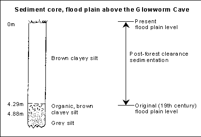
In the last hundred years however, accelerated erosion in the catchment has caused a further three to four metre increase in the level of the floodplain upstream and downstream of the cave. The airspace at the submergence, through which tour boats exit the Cave, is now only 3-4m high and can close completely in flood. Evidence for the change through this century is found in sediment cores from the floodplain, and in historic photographs of the submergence.
Passage height at resurgence (from historic photographs)
1889 20ft 1962 12ft 1974 9ft
Considering this and other evidence, Paul Williams from Auckland University has estimated the following aggradation rates for the floodplain:
General Holocene aggradation rate 0.3-0.5mm/yr Average 20th century aggradation rate 30-40mm/yr Peak aggradation rate (mid 1970s) 60mm/yr
Sediment at the Glowworm Cave
Catchment condition had long been recognised as an issue in the Cave - correspondence from Caves' managers to Wellington through the 1920-30s frequently referred to the disappointment of tourists unable to visit the Glowworm Grotto section of the Cave. In the 1930s, and again in the 1950s, there was some enthusiasm for a cut to divert floodwater through the ridge parallel to the Cave. This was never implemented, partly because the two leading entomologists of the day disagreed about how or whether the glowworm population might be affected. Through the 1950s and 60s, flooding continued to be a problem, but was only seen in an operational context, through the loss of revenue and image on flood days and in the work required to clean paths and jetties after a flood.
The peak aggradation rate occurred in the early to mid 1970s - a 'watershed' period in the management of the cave and in awareness of stream sediment as a more serious issue. In the early 1970s the main road through the Waitomo catchment to the west coast received a major upgrade and widening. As part of this, realignment was carried out along a stretch of unstable sandstone just above the valley floor. Spoil from the new cut was dumped over the side of the road onto slopes and small gullies that descended down to the Waitomo Stream. A barren spoil dump around 20ha in extent was created. Flood events after this time could deposit up to 0.5m of sediment on the inside jetty at the Cave.
Minor desilting was carried out all through these years, generally through the use of high-pressure water or submersible pumps to shift sediment away from the jetty area. In the early 1970s, a major desilting involved the pumping of slurry to waiting trucks. The stream below the cave was straightened and a weir constructed in the 1950s. Annual desilting costs in the 1980s were around $10,000 with the periodic major desiltings costing up to $40,000.
Looking at the catchment
Despite the problems of flooding, few attempts were made to address catchment issues in the early part of the century. The odd bit of correspondence on the issue between the Tourist Hotel Corporation (THC) and the County and Valley authorities in the 1950s and 60s appears to have had little result. But around 1974, the Tourist Hotel Corporation's management of the Cave came into the public spotlight, broadly attacked by the local newspaper, scientists, the NZ Speleological Society and other bodies. In a report by the NZ Speleo Society, Paul Williams and others stated: "The most serious human impact on the Caves has been the sedimentation of the world renowned Glowworm Grotto", and that "the remaining life of the Glowworm Grotto could be less than 50 years" [based on the peak aggradation rate, at that time influenced by the roadworks]. A multidisciplinary, "Waitomo Caves Research Group" was set up that year, funded by THC. Catchment management was a key need recognised by the Group and the research programme included a PhD thesis by David Hawke on fluvial processes in the Waitomo catchment. Amongst Hawke's findings (1976-80 data):
- the erosion rate is a typical lower range value for such catchments in New Zealand
- most of the annual suspended sediment load transport occurs in high energy flows
- the areas requiring most attention are the non-limestone lithologies which are responsible for up to 85% of the solid load carried by the stream
- annual erosion rate (1976-1980 record) (Hawke, 1982):
tonnes/km2/yr m3/km2/yr Dissolved Suspended 83 Bed 108 Catchment Total 229
- erosion rates distributed according to rock type:
tonnes/km2/yr m3/km2/yr Limestone (47% of catchment) solutes 177 66 solids 47 19 Non-limestone (53% of catchment) 235 94
Hawke's work also suggested that the sediment level had stabilised at the Cave by 1982, or at least could be managed by periodic desilting. Despite this, the general recommendation of the Caves Research Group for catchment management still held. Catchment management was still critical to the Glowworm Cave operation:
- to attenuate flooding, which caused lost revenue and lost reputation, and required cleaning up;
- to preclude the need for expensive desilting; and
- to improve stream ecosystem health, which influences the health of the glowworm population. While the glowworm seems to be an opportunistic feeder in general, at the Glowworm Cave site its diet is mostly chironomid midges. These have an aquatic larval stage. Riparian protection would provide organic material, lower stream temperature and generally contribute to a healthy stream ecosystem. Excessive flooding deposits sediment over the benthic chironomid pupae, or in major flood can scour the top layer of sediment away. The optimal sediment load for a healthy glowworm population is assumed to be that provided by a catchment in natural condition.
The first catchment scheme
In the late 1970s, with the backing of the Caves Research Group, THC began lobbying central government for a catchment management scheme. The Waikato Valley Authority produced a report (1980) on catchment condition and a plan to address some of the major erosion sources. Central government agreed to pay two-thirds of the scheme, with the other third split between the County Council and THC. The forecast cost of the scheme was a little over $200,000. Only $64,000 was ever spent before the timeframe for the government share expired in 1982. Most of this was spent on remediating (drainage and reafforestation) the old roadworks spoil site on the road to the coast.
A number of problems other than the timeframe contributed to very limited success of this scheme. One of the most critical of these was the disinterest of community landowners towards a Tourist Hotel Corporation cave business that was seen as an extractive industry contributing little to the local area. A common local attitude to helping with the Cave's sediment problem at that time has been summarised as "bugger the Caves ..."
The 1992 Catchment Scheme
Completion of the Catchment Scheme was promoted again in the early 1990s. Some key factors had changed by this stage. The Glowworm Cave had a new majority owner (1990) in the Ruapuha Uekaha Hapu Trust, while the remaining Crown interest had been transferred from the old government Tourist Hotel Corporation to the Department of Conservation. Central government grants for catchment type work had disappeared as part of a major reorganisation of local government (1988-9), devolving many responsibilities to district and regional authorities. There was also increased community interest, beyond the Glowworm Cave, in such a scheme - the ethic of sustainable land use in agriculture was being promoted nationally, while an increasing number of cave tourism businesses in Waitomo also sought catchment protection.
The new owners of the Cave approached the Waikato Regional Council (the authority responsible for soil and water conservation, similar to the old Valley Authority) about catchment protection in the early 1990s. WRC, better known as Environment Waikato, were keen at that time to try out the 'Landcare' concept. This had been successfully developed in Australia as a grassroots approach to land management, where local communities take the lead in sorting out local issues. Such grassroots approaches had been used amongst communities for many years all over the world, what was new in the Landcare 'concept' was its formal acceptance by statutory authorities as a management tool. Environment Waikato decided that Waitomo was the place to try the concept out, and held a well-attended public meeting in May 1992. Interest was high, and a set of community representatives were elected to the Waitomo Catchment Trust Board (since incorporated as a charitable trust). These representatives came from the farming community (2), tourism (2), iwi (2), District (1) and Regional Council (1), Dept of Conservation (1), QEII National Trust (1) and the NZ Speleo Society (1).
The Waitomo catchment: impacts and strategies
The primary land management and erosion problems in the catchment were the same in 1992 as ever, and similar to those of many other catchments in the King Country region:
- a trend to heavier grades of stock, away from sheep towards cattle, with phases of bull and deer on some properties
- animal pests, such as goats and possums, limiting the rehabilitation of forest remnants
- some soil creep and slip in limestone areas (though these are otherwise generally stable)
- significant mass movements on the sandstone blocks during rain
- continued slumping of road batters
- some streambank erosion
- sheet erosion on the intensively used land
- and erosion from farm access track maintenance and blade disturbance for fencelines
Strategies to address the issues had to take into account farm economics and viability as well as the soil conservation issues. Three broad areas of the catchment were defined in the catchment scheme:
Small floodplain above the cave
This area seems to have a minor impact on water quality with respect to sediment but is important for its riparian influence as the stream approaches the Cave (effect on parameters such as organic matter and water temperature). A problem with riparian retirement is the high economic value of the floodplain as pasture.
Upland valleys
Large and turbulent overland flows tend to reduce the effectiveness of riparian buffers in the main valleys leading down to the floodplain. There is also some economic constraint on works in these areas, because of the large areas involved. Sediment dams were proposed for two of the smaller valleys as an interim measure pending longer term protection from changes in land use and protection.
Steep headwater catchments.
These are often eroding land of low pasture growth. It was proposed to fence these out as far as possible. In the Waitomo project the aim was to retire most Land Use Capability Class VIe8, VII and VIII land (generally the higher the grade the lower the capability of the land, VIII is the highest grade)
The plan
The mechanism for achieving the strategy was a series of Property Protection Plans, covering each of the major farms in the catchment. These were built by Regional Council land management staff in conjunction with landowners and collectively make up the Waitomo Catchment Scheme. The Property Protection Plans are binding on the farm titles in the form of a 99-year Land Improvement Agreement.
The 1992 scheme intended to:
- fence 12km around 330ha of native bush on Class VII and VIII land
- commercially afforest 220ha of Class VI and VII marginal farmland and scrub
- open pole plant 42ha of potential slips
- intensive pole plant 18ha of earthflows
- install two sediment dams
The enthusiasm of landowners for more works expanded the scheme considerably over the next few years. By the end of 1996 the scheme had encompassed:
- fifty kilometres of fencing
- 339ha of commercial afforestation on former grazing land
- 264ha of native forest purchased by QEII (Queen Elizabeth II National Trust)
- 350 ha of native bush and scrubland permanently retired
- three dams and three reticulated water supplies
The estimated cost of the original scheme was around $300,000. The total value of the works in 1996 was $520,000; a considerable increase on the originally intended scheme. Together with $63,000 of works from the 1982 scheme, protection assets in the Waitomo catchment now have a value of around $580,000.
The plan - Raising money
Environment Waikato had indicated from the start that they would contribute 35% of the cost of the scheme over three years. The Waitomo Catchment Trust Board, representing the local community, had the task of raising the other 65%. This was about $200,000 originally, but eventually came to around $340,000 with expansion.
In theory, the community money needed to be raised within three years to gain the 35% share from Regional Council. This was never easily achievable, and while the works were done in three years the community share was raised and paid out right through to 1999. Interim debt (at sixty-five percent) was carried by the landowners, in some cases for several years, on each project.
The plan - typical Waitomo property protection plan from Environment Waikato
The first cheque to roll into the community coffers was arranged by Caves' manager Dave Williams from the local Tavern charity. A large annual commitment was extracted from the operators of the Glowworm Cave, Southern Pacific Hotel Corporation (by asking the Australian office to overrule the recommendation of the NZ office!) The new operators of the Cave, Tourism Holdings Ltd, have since continued with this amount each year. The same amount, for three years, also came from the local District Council (from whom an ultra vires response had been expected) recognising the problems roadworks had caused in the past and the socio-economic importance of tourism in the area. The owners of the Cave (Ruapuha Uekaha Hapu Trust and Department of Conservation) have delivered a similar amount between them each year. Two of the main Waitomo adventure cave operators, Black Water Rafting and Waitomo Down Under, who also run tours through stream caves in the catchment, have contributed smaller but quite significant amounts each year.
The Queen Elizabeth II National Trust is a quasi-government organisation that arranges natural heritage covenants on private land. This has been a remarkably successful organisation nationally, allowing farmers to retain title on their land while protecting many areas of natural value. Several areas of native forest were covenanted, fenced and surveyed at the expense of "QEII", who also purchased outright some 260ha of private forest in the catchment. At the end of the first three years of works, Waitomo had the highest density of QEII covenants in the country and a considerable amount of the required money had been picked up through the QEII.
On the land designated for commercial reafforestation, there clearly needed to be some recognition of the eventual returns. The Trust and landowners agreed that the owners would put in half the costs of plantation establishment, plus all the subsequent silviculture and harvest costs. This effectively gave a 'seeding' contribution from the community to encourage the retirement of the land from grazing. In return, the logging proceeds go to the landowner.
The plan - Asset maintenance
The long-term effectiveness of such a capital works programme may well be determined by the effective upkeep of the works. The basic works are binding on property titles for 99 years as Land Improvement Agreements. These also contain conditions such as the maintenance of fences in stockproof condition and keeping conservation areas free of stock. On top of this, in some cases, are the strict terms of any applicable QEII covenant. The asset maintenance costs for the scheme are estimated at $4500 per annum, with a disaster contingency (damage from slips, flooding etc) estimated at $4000 per annum. Some maintenance costs fall on landowners as part of the Land Improvement Agreements. It seems likely that the community can sustain any residual maintenance costs.
The plan - Results
The benefits of catchment schemes can take many years to accrue, particularly where regolith binding by vegetation is a key process. Stream monitoring through the early stages of the scheme comprised of full time flow measurement with monthly spot sampling of sediment. The available analysis has suggested a sediment level reduction of 60% between 1991-3 and 1994-7. This result needs to be treated with quite some caution due to the limited sample size but is nevertheless a positive sign.
Environment Waikato has recently upgraded the stream monitoring to include automatic sediment sampling programme at high flows. This should provide, before long, sufficient data to enable a comparison with Hawke's work.
The plan: Looking back, and looking ahead
The works programme and fund-raising has progressed fairly smoothly, but not without associated problems. Such issues as pines versus grazing, failure of a sediment dam, and Land Improvement Agreement compliance have raised interesting issues for the community and Regional Council to deal with along the way.
Many elements have contributed to the apparent success of the project. Two of these are perhaps most important in contrasting with earlier attempts at a catchment scheme. Firstly, the participants have been able to work towards their own objectives through common methods, rather than all work to any group's cause. This has seen farmers look for sustainable land use, cave operators look for increased water quality, environmental groups look for protected forest and so on. Contrast the earlier scheme, which was essentially promoted for the benefit of the Caves alone. Secondly, the community approach has brought landowners and offsite benefactors face-to-face in setting policy, raising funds and resolving the real financial implications of catchment protection. This has helped to create a sense of local 'ownership' of the problems (under the guiding hand of Regional Council) that sees issues tackled through consensus rather than ignored or debated fractiously from opposite sides of the fence.
Perhaps a key indicator of success is the ongoing interest of catchment landowners in carrying out more works. In fact the Trust has had to ask landowners to hold back in an effort to create enough breathing space to clear the payments of the first round of works. This is now complete and a Phase II of catchment works is imminent.
Select bibliography/references
NZ Speleological Society, 1974, Report on the Conservation of Waitomo Caves (ed: P Williams), unpublished report
Waikato Valley Authority, 1979, Waitomo Caves Catchment Water and Soil Management Scheme (Technical Publication #9), unpublished report
Hawke D, 1982, Fluvial Processes in the Upper Waitomo Catchment, unpublished PhD thesis University of Auckland
Waikato Regional Council, 1992, Waitomo Caves Catchment Landcare, unpublished report