MT CRIPPS KARST MANAGEMENT - LAND MANAGEMENT, THOUGHTS AND ACTIONS
I remember as a young forester 20 years ago, observing the rather unusual antics of an archaeologist as we walked through the forest on North Forest's freehold land just north of the Mt Cripps area - the archaeologist was not looking up at the trees, which I always find interesting and tell me a lot about the soil, the available moisture and the extent of fire and other disturbances - but rather staring intently at the ground! What a strange way to walk through the forest!
So you can imagine what I thought, when I first went into the bush with Kevin Kiernan and he was interested in what was even lower down - underground in fact!
Now as most of you know, KK has a pied piper quality when it comes to making squirming down a small dark crevice partially filled with icy cold water and rather appropriately named 'rathole', sound like the sort of thing any self respecting land manager should do on weekend, especially when the lawns need mowing and there's some restoration work to be done on the house! Kevin has a bit of the daredevil in him and following him underground reminded me of that saying - "Live every day as though it is your last - one day you'll get it right!" I suspect it was probably one of Kevin's ancestors who discovered frogs legs were edible.
Of course, there is really nothing strange in looking at the ground, or underground when walking in a forest or any area for that matter. What's strange is only looking at one part of any ecosystem in isolation - any part. And I suppose that until I had been underground and looked at the forest from a different perspective, I hadn't really appreciated one part of the ecosystem I was responsible for managing.
As a land manager, my interest must be in considering all parts of the system. And as a land manager, this means I often decide to treat adjacent areas of land differently.
Often it is the physical characteristics of the site that make the difference between two places - tertiary basalt versus conglomerate will affect the vegetation over a very short distance, as will drainage patterns and so on.
Land ownership is also a factor. This explains why the forest type on Crown land may be managed differently from the same forest type on an adjacent piece of private property.
Finding the right course through the maze of options is where the land manager's job starts to get hard.
It is often difficult to find the ideal compromise between conflicting land uses for a parcel of land. The job of the land manager is to obtain the best available advice from recognised experts and to then weigh up this information and make a decision.
I believe it is important to stress that the all singing, all dancing "follow these steps and you'll always be right" set of rules has not yet been and never will be invented.
My plea to all experts is to recognise that while from the expert's perspective the solution is simple (it usually is when you know more and more about less and less until you know everything about nothing) - from the land manager's viewpoint there can be a multitude of experts often recommending different courses of action! I suppose this makes a land manager a person striving to learn less and less about more and more until you end up knowing nothing about everything!
Let's look at the history of the Mt Cripps area from the land manager's viewpoint and follow the process.
But first a bit of background information.
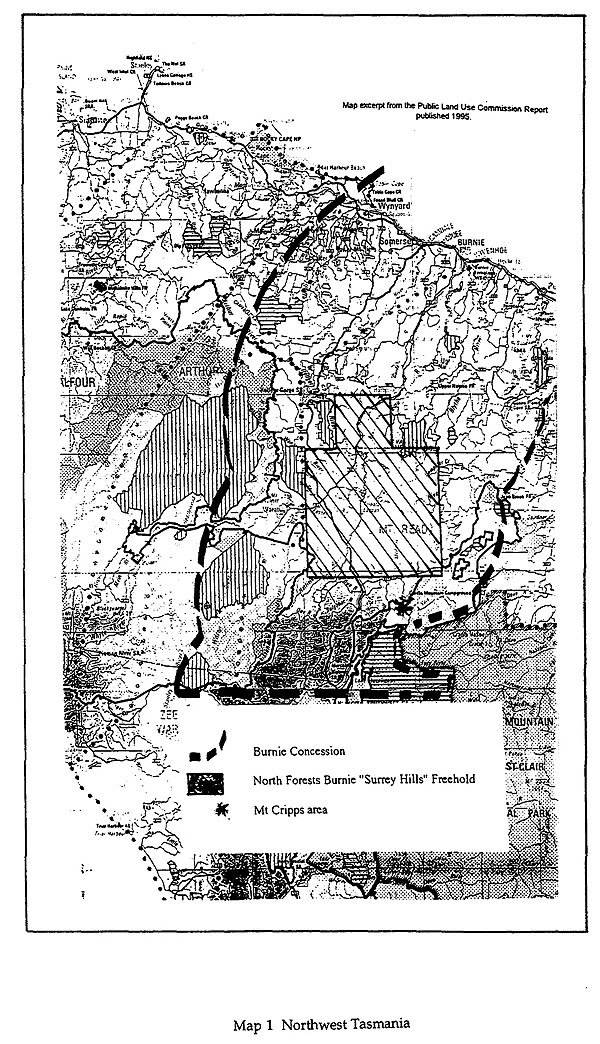
Map 1
North Forests Burnie is responsible for managing the largest area of Freehold forest in Tasmania - an area over 1,200 square kilometres in size (see Map 1). The majority of this land is in the North West and is in the region south of Burnie around the prominent mountain St Valentines Peak. This block of Company owned forest is known as Surrey Hills - so called by the first European explorers in 1827. Surrey Hills has provided resource for most of the forest based industries in North West Tasmania for over the last 50 years, especially for the pulp and paper mill complex established in Burnie in 1938. Surrey Hills is being managed for tree farming, with large areas of reserves.
As well as the resource on the private forests of the Company, in the earlier part of this century, the State government allocated concessions on large areas of land to encourage the development of the fledgling pulp and paper industry. In the North West Tasmania, the Burnie Concession, over 25,000 square kilometres in size, was allocated to the founders of what is now North Forests Burnie. It included all the area surrounding the Surrey Hills block and included the area known as the Bulgobac block, which includes
Under the Concession system, North Forests Burnie was responsible for most of the planning, roading, regeneration and fire fighting in the Mt Cripps area, with the State Forestry Service providing additional controlling activities. This system is being progressively replaced with more formal control by the government authorities in a manner supported by North Forests.
Mt Cripps was an important area for wood production in the early 1980s. The first logging operations provided very high quality sawlog and veneer, used in at least sawmills and one veneer mill in the region, as well pulpwood for the Burnie mill. The first coupe was on the southern edge of the tertiary basalt flow which extends northwards from Mt Cripps to the coast. Logging activity had extended from the north around the western side of Mt Cripps and these basalt soils were what everyone was used to. The road was extended to access the next ridge of timber. At this stage, there didn't appear to be anything too unusual, with some small patches of limestone identified in the preliminary inventory of the area. Closer field inspection soon indicated that the geology and contour maps for the area were not accurate due to the impact of the karst.
Following some further field inspection and the discovery of numerous caves, it was obvious to me that the area could not be managed in the same way as the adjacent coupes to the north.
As you heard on the field day yesterday, the input of Kevin Kiernan and the Savage River Caving Club was sought to provide the land manager with the necessary information to decide what could be done regarding further development.
Logging activity was halted and a gate put up to ensure unauthorised access to the caves was restricted. The enthusiasm often associated with unmanaged cave exploration can often be detrimental to fragile cave ecosystems. The balance between getting additional information and the damage this can cause needs to be a part of the land manager's considerations.
The important point here was that the decision was to manage the area for its karst and geomorphological value, rather than to just manage it for its wood production values. This has meant funding for photography, some climbing equipment, ongoing management of controlled access and maintaining the road for at least an extra 5 years, rather than putting it to bed immediately were all a part of this decision.
There is a message here for all those involved in the specialised management of caves and karst - try to understand other people's perspective. The land manager must in many cases look for a compromise. The experts need to recognise their advice forms only part of the spectrum of information which the land manager must and indeed should consider.
Good land management involves recognising when compromise is not is an option. In the case of Mt Cripps this meant that when the land manager considered the value to society of harvesting the large tracts of commercially valuable timber, the importance of the karst was deemed to be greater and so an active management decision was made to cease all harvesting within a zone determined by a recognised karst expert.
The Mt Cripps area and the surrounding high quality forest has been set aside to allow at least 10 years for further scientific study to be carried out, especially with respect to the karst.
The contribution of the local caving club was important in establishing the extent of the karst - that involvement is ongoing, including a commitment to provide a detailed survey of every find and to advise of any floral or faunal signs - driven in part no doubt by the anticipation of the next find being deeper, longer, and more challenging than all that have come before!
They have produced some excellent mapping information on the extent and detail of the karst caves (see Figures 2 and 3).
Good communication and willingness to listen is important. Karst expert, volunteer speleos and other experts from Forestry Tasmania and other government departments all provided input to the land manager.
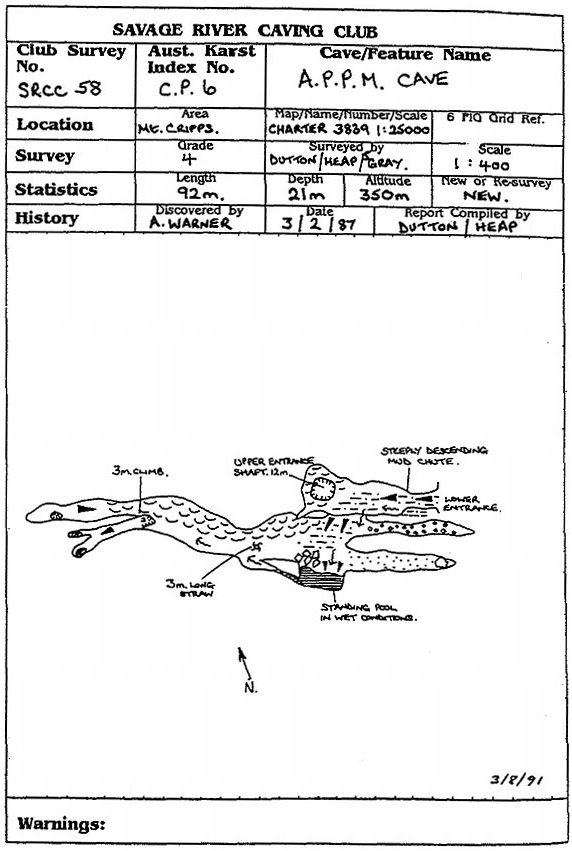
Figure 2 APPM Cave, Mt Cripps (Savage River Caving Club)
There is a postscript to the Mt Cripps experience - following the timely conversion of the Concession system to a contract to supply wood products with the co-operation of all players, the 1926 Burnie Concession Act will shortly be repealed and Forestry Tasmania will take up the role as the primary land manager.
While I cannot speak for the land managers in Forestry Tasmania, I believe that the planning systems in place in the State are capable of ensuring the Mt Cripps area continues to be managed principally for its karst value, with the active, enthusiastic and disciplined involvement of the local caving group.
For you see effective land management only starts with the decision on what to do with a parcel of land - the ongoing active management process involves continually updating the information on the area, revising the options available and regularly reviewing the information. Land management is a dynamic process.
This is not unique to karst, but has been applied by North Forests in dealing with the native high altitude grasslands and the Ptunarra butterfly, with the early archaeological activity of the Van Diemen's Land Company and with the revision of the location of eucalypt tree farms all on North Forest's Surrey Hills estate to name just a few other examples.
Mt Cripps is an example of how joint effort can facilitate successful land management practices. I wish it a continuing history of active management.
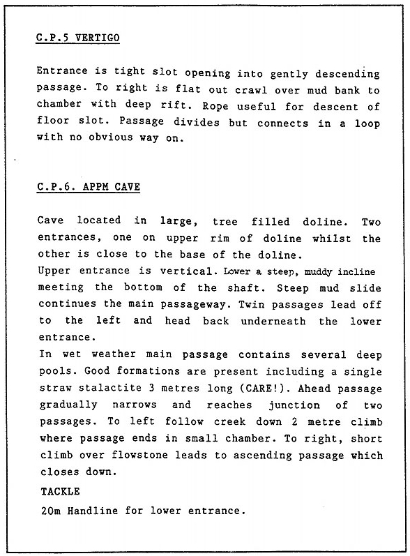
Figure 3 Cave descriptions, Mt Cripps (Savage River Caving Club)