Geoconservation in karst areas
ABSTRACT
Geoconservation is concerned with the retention of geodiversity, the variety of geological phenomena, landforms and soil types that comprise the geosphere. Geoheritage may be of conservation significance for intrinsic reasons or for a variety of instrumental purposes, such as the value of sites for science, education or tourism. A site may be important as a natural feature or as a place that displays a natural process in operation. Landforms and soils are generally the most vulnerable components of geodiversity in management terms. This is because changes caused by development to the surface contours of landforms, at whatever scale, by definition implies damage to the natural geomorphology. Hence, it is important to have the capacity to assess the significance of the landform involved and the significance of the damage to be caused. There are species and communities of karst landforms just as there are species and communities of plants and animals - there are various different types of caves, sinkholes, residual hills, karren and so forth. Just as it is important to retain living species, so too is it important to retain representative examples of all landform species, and also landform communites such as caves and their associated sinkhole complexes, areas of polygonal karst of different types, or inter-related suites of glacial and karst phenomena in glaciokarsts. Sites that are oustanding in some way also require safeguarding. As with living species, some landform species are common and some are rare, some are robust and some are fragile. In karst areas the adoption of a systems perspective is critical to effective geoconservation. Analysis of geoheritage can usefully be pursued at four levels: (1) the natural systems level, that is, the mix of environmental controls that condition landform evolution in an area; (2) the landform species and landform communities that are present; (3) landform contents, including sediments or biota contained within sinkholes and caves; and (4) human use and aesthetic considerations. This paper discusses some of the general principles of karst geoconservation and outlines some results of the Tasmanian Karst Atlas Project and their implications for karst geoconservation in Tasmania.
INTRODUCTION
Geoconservation is concerned with the retention of geodiversity, the variety of geological phenomena, landforms and soil types that comprise the geosphere. Geoheritage may be of conservation significance for intrinsic reasons or for a variety of instrumental purposes, such as the value of sites for science, education or tourism. A site may be important as a natural feature or as a place that displays a natural process in operation. While geoconservation focuses on landforms as phenomena of importance in their own right, it also recognises the fundamental role of landforms in conditioning biodiversity, and recognises the desirability of protecting places that are essential to the maintenance of natural ecological processes.
Geoconservation programs are well developed in some countries, but recognition of geodiversity as a focus for conservation has not hitherto been universal. Within Australia, the Australian Heritage Commission has supported some geoconservation programs, notably inventory work in Victoria, while some other studies have also been undertaken (eg. Eastoe 1979, Joyce and King 1980, McRae-Williams et al, 1981, Kiernan 1984a, 1994b, Davey 1984, Rosengren 1984, Rosengren et al, 1981, Rosengren and Peterson 1989). Reviews of the evolution of geoconservation in Tasmania, and methodological considerations therein are available (Kiernan 1989a, Sharples 1993a). Outside karst areas, progress is being made statewide on geoheritage inventories (Bradbury 1993, 1994a, 1994b; Dixon 1991, 1994; Sharples 1994a, 1994b, 1995).
The need to identify and protect important components of Australia's karst heritage has been addressed by Jennings (1983), and some methodological considerations have been reviewed by Davey (1984) and White (1991). A conservation assessment of Victoria's caves has been undertaken (Davey and White 1986). The significance of the alpine karsts of mainland Australia has been discussed by Spate and Houshold (1989). Attention has also been drawn to the desirability of developing a register of important karst sites worldwide (eg. Rojsek 1987), including potential candidates for World Heritage nomination (Ford and Williams 1989).
For many years virtually the only Tasmanian karst features that have been considered of sufficient import to warrant protection have been limestone caves, and very few even of these have been reserved. In more recent years the need to embrace a wider range of karst phenomena has been recognised and steps have been taken towards the identification of the most important karst features (Kiernan 1984a, 1989c, in press, Kiernan and S. Eberhard 1993, R. Eberhard 1994). In the joint Tasmanian Government - Australian Government nomination of the Tasmanian Wilderness to the World Heritage List, broader karst values were specifically cited in arguing that the area met all four criteria with respect to natural values, and also three of the six possible criteria for listing of the area for its cultural heritage values. Implicit in the subsequent inclusion of the wilderness area on the List of the World's Cultural and Natural Heritage is international acknowledgement of the importance of the karsts that it contains. However, only part of the range of Tasmania's karst phenomena is contained within the World Heritage Area (WHA). Much karst geoheritage that is of equal importance remains outside the WHA and demands the most careful and protective management, irrespective of its present land tenure.
The protection of important landforms has been enshrined in the Tasmanian Forest Practices Code since its inception in 1978. Geodiversity has also been addressed during the Tasmanian Forests and Forest Industry Strategy process (Podger et al 1990), and the conservation of landforms is a stated requirement of Forestry Tasmania under the Public Lands (Administration and Forests) Act 1991. Formal reservation is required in some cases, as is the situation with the Mill Creek - Kansas Creek area in Tasmania (Kiernan 1984a, 1989b, Spate and Holland 1990, Kiernan et al 1994) and the Mole Creek System itself (Jennings 1980, Kiernan 1984a, 1989c). In both these areas sufficient documentation has now been completed to amply demonstrate the need for full protection and appropriate management.
A SIMPLE FRAMEWORK FOR THE IDENTIFICATION OF KARST GEOHERITAGE
Tasmania's karst estate contains a wide variety of resources. This paper focusses on the identification of geoheritage. Various components of Tasmania's karst are of nature conservation significance at scales ranging from local to international. In addition to geoheritage considerations, some of Tasmania's karst environments are also places where people work and live. A variety of natural geomorphic hazards potentially confront these residents of karst areas, including the vulnerability of soils and aquifers to degradation, ground surface instability and foundation difficulties (Kiernan 1988a, 1990b). Some Tasmanian karstlands have been formally reserved for conservation or have the potential to be formally reserved, reducing some potential human impacts. Where reserve status does not exist, the potential for geoheritage degradation and for karst geomorphic hazards to impact adversely on communities must be taken into greater account, and alternative strategies are necessary if karst geodiversity is to be safeguarded.
A simple framework for the identification of karst geoheritage has been developed as part of the Tasmanian Karst Atlas Project (Kiernan, in press) and adapted to geoheritage work in some other terranes. Analysis of geoheritage can usefully be persued at four levels: (1) the natural systems level, that is, the mix of environmental controls that condition landform evolution in an area; (2) the landform species and landform communities that are present; (3) landform contents, including sediments or biota contained within sinkholes and caves; and (4) human use and aesthetic considerations.
The need to recognise and appropriately manage landform communities is particularly important when it comes to protecting karst caves. For example, the protection of cave stream and dripwater catchments and the system of sinkholes and often very small scale conduits that deliver it to the cave is critical to effective protection of the caves that have formed in most temperate karsts, including those in Tasmania (Figure 1). Sound management of the condition of the soil and vegetation systems above a cave is also a critical factor. For example, vegetation clearing can lead to increased biological activity in the soil as a result of increased exposure to the sun raising soil surface temperatures. This may have the potential to give rise to an increase in soil carbon dioxide concentrations and, hence, an increase in the acidity of dripwater that reaches the caves. Under such circumstances speleothems can probably be redissolved. Karst processes can be significantly modified by short term changes to plant/soil/water relationships (Harmon 1977, Jakucs 1987, Kiernan 1987h, 1989b,k). The impact of visitors to caves is also likely to be profound and must be taken into account in planning (Spate and Hamilton-Smith 1991).
SOME GENERAL PRINCIPLES OF KARST GEOCONSERVATION
While an excessively reductionist perpective is not appropriate to the management highly systemic phenomena such as a karst, if the goal is retention of natural diversity, then the components that make up that diversity need to be spelt out. The landform kingdom is divisible into various orders, families, genera and species just as the plant and animal kingdoms are divisible in this manner - there are various different kinds of cave, sinkholes, residual hills, and karren for instance, and variants upon these. Only by means of a sound and broadly-based categorisation system can the relative frequency of a particular landform type, and its conservation status, be properly assessed. The recognition of the concept of there being karst landform species and communities in the joint Tasmanian Government - Australian Government nomination of the Tasmanian Wilderness for inclusion on the List of the World's Natural and Cultural Heritage highlights the growing recognition of the requirement for a protective system that is adequately representative of the natural geodiversity of Tasmania's karst. The need to recognise the interactive nature of karst systems has also been addressed in the Forest Practices Code, in the World Heritage nomination of the Tasmanian Wilderness, and in the decision by the Australian Government to close a limestone quarry in the Exit Cave karst system.
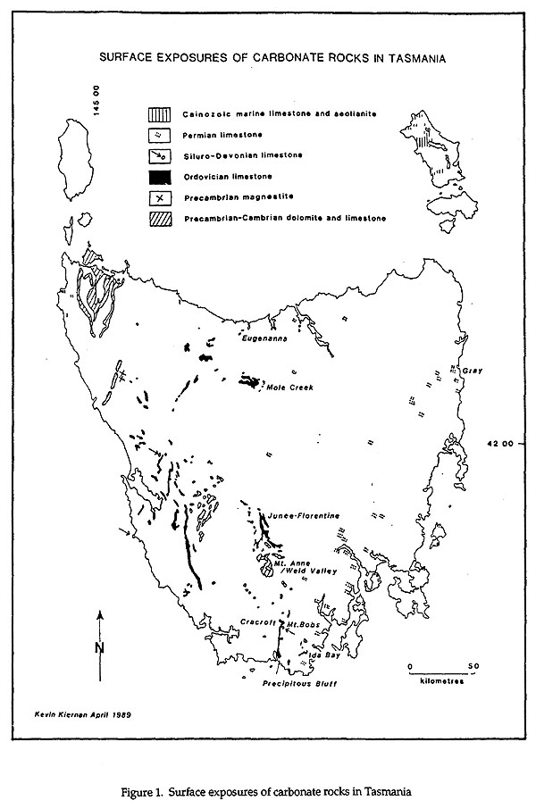
Fig 1
Assessment of the significance of particular karst landforms may be based on one of two principal concepts. A site may be considered significant because it is outstanding in some way (eg. a particularly well decorated cave) or because it is representative of the class of landform to which it belongs (Davey 1984). The latter approach is less fraught with problems caused by different tastes and changing fashions, and is the only basis upon which biodiversity or geodiversity can readily be identified and retained. This will also facilitate the more adequate protection of the functioning of the wider ecosystems that are dependent upon landforms (Sharples 1993a). Davey and White (1976) have spelt out fifteen additional criteria that may make a site significant, including:
- its having contributed significantly to explanations about a wider class of sites
- its being the location of important research
- its providing evidence for understanding the past
- its holding important prehistoric or historic associations
- its being the type locality for any species
- its being the habitat of an endemic species
- its being the habitat for any troglobitic species
- its being a breeding, acclimatisation, overwintering, staging or roosting site for any species
- its being of high visual or other sensory quality
- its containing unusual recreation opportunities
- its having the potential for non-destructive use that will contribute to local and regional economy and employment
- its being one of the few remaining or best preserved examples of its class
- its being part of a related complex of sites that collectively meets one or more of these criteria.
The appropriate management response to the presence of significant karst geoheritage will vary according to the particular circumstances. As with plant and animal species, some landform species are rare and others are common, some are robust and some are fragile. Management of particular sites needs to take such considerations into account. Scale is often a factor in determining fragility - for example, a helictite might be broken simply by a careless visitor brushing past it, whereas the morphology of a large residual strike ridge of limestone is unlikely to be damaged other than by heavy earth moving, road construction or quarrying. It must be recognised that geomorphology is concerned with the shape of landforms, and that changes to the ground contours at whatever scale by definition necessarily implies damage. The important question is whether that damage matters in a particular case. Hence, it is essential to identify at the outset which landforms are important, and what threats to their integrity may exist. The intended function of a particular site also needs to be clear at the outset - is it to be protected to display ongoing karst processes in operation, as a representative example of that particular class of landform, or for its potential scientific value for a particular thematic or regional research topic? In the latter case, if destructive sampling methods are likely to be accepted, then additional examples that will be retained intact need to be identified and appropriate management initiated (Kiernan 1989a).
This latter issue raises the question of how many examples of a particular phenomenon it is appropriate to protect. No biologist would ever consider the protection of simply one individual of a species to be sufficient, and the same situation faces workers in geoconservation. Accidental damage or unanticipated process changes may mean the loss of a geoheritage species entirely if only one example is safeguarded for posterity. The degree of replication appropriate is dependent upon such factors as the rarity, sensitivity, scientific significance and ecological importance of a class of feature. Moreover, if diversity and sustainability are to be maintained at regional or greater scales protective management of similar species may need to be replicated across entire regions (Sharples 1993). Because of their wide geographical distribution Australia's caves, for instance, offer opportunities for broad scale studies such as that of climatic change across the continent. This cave heritage totals more than just the sum of its parts, and each karst area forms part of a set the value of which cannot but be diminished by the loss of any of its constituent parts (Spate 1987).
LANDFORM SPECIES LISTS FOR TASMANIAN KARST AREAS
Karst area attributes are the product of the range of system controls that condition the evolution of a karst area, including factors such as lithology, structure, climatic and palaeoclimatic factors, the nature of the solvent system, whether the solvent falls directly onto the karst as rain or reaches it as a concentrated stream flowing from adjacent non-carbonate rocks, topographic setting, and the relationship between geological structure, drainage direction and the direction in which caprock is stripped. The specific features of potential geoconservation interest are those landforms and landform assemblages, landform contents, and opportunities for human use and aesthetic appreciation. As part of the Tasmanian Karst Atlas Project (Kiernan, in press), lists of potential karst landform types and variants have been developed, and on the basis of presently existing knowledge, their presence in any of the 300 carbonate rock localities identified in Tasmania has been recorded. This represents a first step along the path to developing landform species lists for each karst, a style of karst landform documentation that should ultimately permit the real diversity of Tasmania's karst to be recognised and targetted by protective management strategies for particular karsts. This inventory structure will no doubt be modified and refined by future workers as further areas are studied and documented, but at least we now have a framework that appears workable.
However, assessing the significance of a particular landform must involve reference back to the systems context within which it occurs. This is because a landform of a class that may be common and of little geoheritage significance in one context may well be of interest should an example be found in another less usual context. For example, a small and moderately well decorated cave in the Cashions Creek Limestone of the Gordon Group may be of no more than moderate interest since they are relatively common, but should a similar cave be found in one of the Permian limestone formations it would be of considerable interest since these rocks appear generally non-cavernous.
Because the maintenance of karst geoheritage values is so highly dependent upon appropriate management of the systems within which they occur, it is not appropriate to provide point locations in developing a data base of karst landform species present around Tasmania. At worst this could lead, for instance, to protective management being afforded to a cave entrance while the lands that overlie the majority of the cave and the catchment of the streams that flow into it are ignored. For this reason, coupled with the fact that full documentation of all karst areas is clearly beyond our capacity to acheive at the present time, specific grid references are not provided for the individual features identified. It is better simply to say at this stage that they are known to occur in those karsts indicated. The free availability of specific locational information is also undesirable in the case of sensitive caves or other features that are not presently afforded any significant management at the site level and hence are potentially open to damage by excessive or careless visitors or by vandals. The concept of protecting landform assemblages or communities rather than merely individual examples of a species relates to this need to recognise the interdependence of landforms with the range of influences that have conditioned their evolution or are important for their ongoing evolution.
While the landform species lists presently available provide a useful step towards establishing a list of important sites, no attempt has been made at this early stage to tabulate occurrences of specific landform types against the areas in which they are known to occur. It is probably too soon to undertake such an exercise in a manner that can give meaningful results. However, some preliminary assessments are possible in those cases where the evolution of a particular landform species requires a particular mix of system controls that is only very localised in occurrence.
ASSESSING CONSERVATION STATUS: (1) THE SYSTEMS LEVEL
One example of a system mix that is highly limited in occurrence is provided by the Fairview (Redpa) karst (NW11) in northwestern Tasmania. This is the only Tasmanian karst hitherto documented where marine carbonate formations of such widely differing age are involved and indeed in contact, in this case being of Precambrian and Tertiary age. Karstic drainage between the two formations is integrated. The area represents the only significant terrestrial karst formed in Tertiary limestone on the Tasmanian mainland. In terms of the landforms present, the karren assemblage formed on the Tertiary limestone is particularly rugged in comparison with other inland karsts in Tasmania, exhibiting some morphologies closer to those exhibited by Pleistocene aeolianites subject to coastal processes of weathering and erosion. Future research potential includes the possibility that, given the relatively low altitude of the site, and relatively recent coastal uplift, it is possible that fossil coastal karst features persist in the Precambrian rock and have influenced terrestrial karstification, and even the possibility that palaeokarst fills of the later Tertiary limestone may prove to be present.
Another example of a system that is very limited in distribution is the karst formed in magnesite that occurs in the Tarkine area in far northwestern Tasmania. No magnesite karst has been recorded from any other part of Tasmania and it appears very rare at a national level. While magnesite occurs in various parts of the world no discussion of magnesite karst is contained in any of the standard contemporary texts on karst, although in a few cases overseas karstic cavities have been reported (Bodenlos 1950, 1954, Gale 1912, Hess 1908, Turner 1993). Although there is little specific literature on karst in magnesite (eg. Klir 1968) the point is made by Turner (1993) that magnesite is less soluble than some other carbonates under some field conditions. Hence, the lithological system is unlike many other carbonate karsts and this in itself makes karst occurences in magnesite significant targets for geodiversity retention initiatives. The presence of Victory Springs implies the existence of an integrated subsurface drainage system. None of the Tasmanian magnesite karst has any form of protection. The magnesite has already been explored as a possible source of industrial magnesium and for its possible use as ornamental marble. It has been disturbed by past mining near Victory Springs and to the south, and in the former area defacement and subsequent erosion of one hillside during mineral exploration has been very severe, demanding a substantial revegetation exercise despite which it is likely to remain exposed and eroding for decades to come.
ASSESSING CONSERVATION STATUS: (2) THE LANDFORM COMMUNITY LEVEL. THE EXAMPLE OF POLYGONAL KARST.
The term "polygonal karst" (Williams 1972) refers to a karst environment in which no apparent legacy remains of the original landscape that existed prior to the exposure of the carbonate bedrock. In conventional landscapes the alignment of ridges and valleys is often superimposed from one set of rocks onto the deeper rock units as the landscape is eroded. In polygonal karst all trace of the earlier pattern of hills and valleys has vanished and the whole land surface has been consumed by sinkholes to produce a landscape somewhat akin to the inside of an egg carton. All parts of the land surface form parts of sinkholes, and the only surface drainage divides that are identifiable are the polygonal patterns of residual crests that separate the sinkholes. No apparent direction of drainage can readily be inferred, even incorrectly, from the surface topography. In such areas stream channels are not the focus of incision and landscape change, instead the base of sinkholes forms this focus.
Polygonal karst is probably best developed in the humid tropics, but in Tasmania there are four small localities in which landscape of this kind is developed: east of Sensation Gorge in the Mole Creek karst (Kiernan 1984a, 1989c); in parts of the Mt Cripps karst (Shannon et al, 1991); in the Nelson River Valley (Kiernan 1980b, 1983b); and, less well developed, in part of the Marble Hill karst (Houshold and Spate 1990, Kiernan 1990a).
Significant differences exist between these four areas of polygonal karst. Most are formed in limestones of Ordovician age, but the limestone in which the Nelson River assemblage has formed may be of Devonian age. At Mole Creek the sinkholes are formed largely in unconsolidated sediments that overlie limestone whereas at the other sites they are formed in bedrock limestone. At both Nelson River and Mt Cripps the polygonal karsts have been repeatedly glaciated leaving an obvious glacial geomorphic legacy, particularly at the former. The Mole Creek site has been glaciated but the present polygonal karst probably postdates the glaciation and there is no unequivocal glacial geomorphology present there. The Marble Hill site has not been glaciated, but palaeokarstic sediments in the area suggest a very long history of karstification. The Mt Cripps site is considerably larger than the other three, Nelson River is perhaps the most visually striking but, while smaller, the Mole Creek site is also striking and is very accessible. The polygonal karst at Mole Creek bears some resemblance to that at Ida Bay in being focussed along a geological contact where surface runoff from non-carbonate rocks sinks underground. However, at Mole Creek it has evolved partly in response to surface runoff from an anticlinal core of subjacent rocks and subsurface drainage from a neighbouring karst-margin polje, whereas at Marble Hill surface runoff from across a fault boundary appears to have played a prominent role, in concert with surface runoff from non-carbonate sediments that overlie the limestone. The Mole Creek site is the better developed and more extensive of these two.
At Nelson River large allogenic streams that drain through the limestone have aided removal of material from beneath the evolving sinkholes; some similarities exist in the Mole Creek case but the situation there appears more complex. The importance of the Mole Creek site is increased because the polygonal karst is formed at the margin of a karst-margin polje (the Mayberry polje) and a major valley that is seasonally dry (Sensation Gorge), both being landforms that are of geoconservation significance in their own right. Baseflow drainage from the polje, intercepted from its previous course through Sensation Gorge (Jennings 1967, 1985), has facilitated evolution of the polygonal karst through its removal of weathering products from beneath the evolving sinkholes. Hence, the Mole Creek polygonal karst is both a landform community in its own right, and part of a broader landform community that also includes the Mayberry polje and Sensation Gorge.
The contents of the karst landforms in areas of ploygonal karst can add to their value. At Mole Creek the sinkholes contain a botanical community that is of scientific interest, and formal reservation of the area has previously been proposed for this reason alone (Whinham et al, 1989). At least one cave in the Nelson River area is of archaeological importance, and the rainforest in the sinkholes at Mt Cripps is an important attribute to those who use the area for recreation.
Hence, each of these four areas of polygonal karst contributes significantly to Tasmanian karst geodiversity. However, only the Mt Cripps site remains wholly intact. The Nelson River polygonal karst is now partly submerged beneath the Lake Burbury hydro-electric impoundment, flooding features and flattening the hydraulic gradients that enabled it to evolve. Limestone quarrying has engulfed part of the Ida Bay site and the caves that drain it have been polluted by runoff from the quarry. The Mole Creek site has been damaged by road and track construction, quarrying, and so many years of use as a refuse disposal site that some of the sinkholes have been filled totally. Although use of this site by the local municipal council has recently been halted, this history of dumping has had an obvious impact upon the integrity of the site and has created a long term hazard for humans since leakage of waste materials from the sinkholes or collapses as the polygonal karst landscape continues to evolve, may enable dumped materials to reach the underground watercourses that provide much of the water that feeds Sassafras Creek, which is used locally for domestic supplies.
ASSESSING CONSERVATION STATUS: (3) THE INDIVIDUAL AND FORM LEVEL. THE EXAMPLE OF WARM KARST SPRINGS.
Warm springs are locally noteworthy features in some Tasmanian karsts. It is likely that few significant warm springs remain to be discovered, hence some useful assessment of the significance of the known sites is possible. They are most abundant in Precambrian dolomite, but occur more rarely in Gordon Group limestones and, perhaps uniquely in the world, one has formed in magnesite. All occur at low altitude in areas subject to high annual rainfall totals. One occurs on a hill flank but the others lie on plains of either riverine or coastal origin. Some variety exists in the lithological systems involved.
Warm springs in dolomite:
There may be a couple of dozen dolomite warm springs in the Smithton area, but the tract of country where they occur has been heavily modified by agricultural practices, the natural vegetation stripped, and major canalisation undertaken. Some of the smaller spring-mounds have been erased totally in land development and the others degraded in other ways, including the excavation of deep drainage ditches through their flanks. In some cases other excavations associated with building construction or quarrying have taken place. Certainly the largest examples of the dolomite mound springs around Smithton are highly degraded. The other site at which warm springs are known in dolomite is in the Hastings district. Here there are no evident spring mounds. The principal outlets have been heavily modified to form or feed the artificial swimming pool that has been constructed at the site. A couple of other small sites are known at which warm water emerges.
Warm springs in Precambrian magnesite:
Victory Springs in the Keith River area is a warm spring that issues from a conduit system formed in magnesite. There are three known sites of warm water emergence, located close to one another on the northern bank of the Arthur River. All the emergence points have been damaged by bulldozing, and the extent of damage immediately upslope and downslope is such that if any other seepages are present they can no longer reliably be discerned from the deranged surface flow from the principal outlets. A pipe from the muddy pool at the largest outlet flows to a holding tank and shed adjacent to which there is a sign: "Thomas's Cascading Natural Mineral Spring Water".
Warm springs in Gordon Group limestones:
Circumstantial evidence suggests that the warm springs at Kimberley may be of karstic origin and related to solution channels in subsurface Ordovician limestone. Irrespective, this site has been heavily modified, the natural vegetation removed facilitating slopewash of sediment into a much modified emergence pond now partly choked with weed. Discharge from the pond has been further impeded by interference with the outlet channel further downstream. At Loongana, the water that emerges from at least one mound spring is warm. Once again, the natural vegetation surrounding the mound springs has been removed, the spring carbonate surfaces degraded by stock trampling, and at least one spring mound has been excavated. On the Lune Plains in southern Tasmania, McLeods Springs have to date fared rather better and are perhaps the best example of unmodified warm springs remaining intact anywhere in Tasmania. They warrant the highest level of protective management.
Tasmania's warm springs therefore exhibit an interesting diversity, one of the springs being of a kind that hitherto may not have been recognised, or indeed exists, outside Tasmania. Spring mounds are a noteworthy feature of some spring sites, the spring mounds at Mella being the largest known in Tasmania. At present, the conservation status of warm karst springs in Tasmania is very poor. In addition to the desirability of retaining representative and outstanding examples of these different types of warm spring as part of a process of retaining geodiversity, warm springs are also of interest to many in the community. The latter point is evident from the frequency with which popular picnic sites or access facilities have been established at springs that occur on public land.
Some warm springs are also of considerable scientific value. Particularly where mineral precipitation occurs, the biota in the springs is readily fossilised. The fossil record is commonly contained on the margins of the spring sites or the flanks of spring mounds such as those that occur in the Smithton area and at Loongana. Some limited palaeontological study has been focussed on one or two of the warm springs in far northwestern Tasmania, principally involving studies of fossil vertebrate fauna and palynological studies of material trapped in the carbonates that have been precipitated at spring discharge points. These studies have facilitated the interpretation of late Pleistocene environmental change in the local area (van der Geer, 1981). However, the potential for work of this kind is far from exhausted. Moreover, warm springs are also good environments for bacteria and algae. While some attention has been given to study of the warm spring biota at places like Rotorua in New Zealand and Yellowstone in the USA, the biota of Tasmanian warm springs is unstudied. Investigation of some warm spring deposits has revealed the existence of stromatolites and recent work in North Queensland has shown preservation of 300 million year old fossils down to the scale of microscopic cells (Walter, 1994). The fossil record, and certainly the retention of the natural processes operating at the spring site, can readily be compromised by disturbance of the spring margins. For these as well as practical site managment reasons, care is required in management, including visitor management.
CONCLUSIONS
Serious deficiencies exist in the existing system of cave reserves in Tasmania, in terms of the range of phenomena included, the legal standing of the reserves, and also often in terms of the design of some reserve boundaries, which sometimes include little more than the entrance to the targetted cave and leave unprotected most of the cave and its catchment, as at Croesus Cave and Gunns Plains Cave (Kiernan 1974). Some proposals to improve the protection of karst geoheritage through formal reservation have been advanced in the past, others await development (Kiernan 1984a, 1989, Podger et al, 1990, Dixon 1990, R. Eberhard 1994, Kiernan et al, 1994). On the other hand, many of Tasmania's karsts have already been subject to various forms of development, and are no longer in a natural condition. Development of some important Tasmanian karsts has included activities such as farming, forestry, mining, tourism, and the construction of dwellings and towns, with the attendant issues of servicing, including the problem of waste disposal in a situation of high aquifer vulnerability. Significant economic and political difficulties would be entailed in the formally reserving some of the important features they contain, and in any case it is not always necessary to preclude all forms of economic use provided appropriate strategies are put in place with respect to particular threatening processes. Obviously not all karst geoheritage values are necessarily extinguished by partial development of the land surface in a karst catchment.
Many important values remain in Tasmania's developed karsts, such as the caves in the Mole-Lobster divide and in the Croesus area at Mole Creek, the Dogs Head Hill hum, and the Mayberry polje and polygonal karst in the same area. Similarly, important phenomena remain in good condition in the Junee-Florentine karst, Gunns Plains karst and elsewhere. While reservation seems the appropriate path to tread in these particular cases, in others alternative strategies might be adopted. One of the most powerful sources of the wish many have to formally reserve important karst sites is the present lack under other tenures of effective legislative protection against total removal of features by activities such as potential future limestone mining. Were this situation otherwise, then the potential for a more multiple use approach to geoconservation would be far greater. Decisons need to be taken as to the most appropriate use of important Tasmanian karst sites, not only whether a proposed or existing use for one purpose or another might be sustainable. However, sustainable management of Tasmania's karst environments, for whatever purpose, including geoheritage conservation, is not attainable unless the karst context is taken into account and catered for fully.
REFERENCES
Bodenlos, A.J. 1950, Magnesite deposits of Central Ceara, Brazil. Bul. US Geol. Surv. 962-C.
Bodenlos, A.J. 1954, Magnesite deposits in the Serra das Eguas, Brumado Bahia, Brazil. Bul. US Geol. Surv. 975-C.
Bradbury, J. 1993, A Preliminary Geoheritage Inventory of the Eastern Tasmania Terrane. Unpublished report, Parks & Wildlife Service, Hobart.
Bradbury, J. 1994a, Continuation of Preliminary Earth Heritage Inventory - Central, Northern and Western Tasmania. Unpublished report, Parks & Wildlife Service, Hobart. 81pp.
Bradbury, J. 1994b, Significant Earth Heritage Sites on the Lower Gordon River. Unpublished report, Parks & Wildlife Service, Hobart.
Davey, A.G. (ed) 1984, Evaluation criteria for the cave and karst heritage of Australia. Helictite 15(2): 1-41
Davey, A.G. & White, S. 1986, Management of Victorian Caves and Karst. A report to the Department of Conservation, Forests & Lands, Victoria. Applied Natural Resource Management, Canberra.
Dixon, G. 1990, The Appropriate Boundaries of a World Heritage Area in Western Tasmania. Dept. Parks, Wildlife & Heritage, Hobart.
Dixon, G. 1991, Earth Resources of the Tasmanian Wilderness World Heritage Area. Dept. Parks, Wildlife & Heruitage Occ. Pap. 25.
Dixon, G. 1994, A Preliminary Geoheritage Inventory of King Island. Unpubl. report, Parks & Wildlife Service, Hobart.
Dixon, G. & Bradbury, J. 1994, Management of the lower Gordon River. Ranger 29: 15-17.
Eastoe, C. 1979, Geological Monuments in Tasmania. Geological Society of Australia (Tasmanian Division).
Eberhard, R. 1994a, Inventory and Management of the Junee River Karst System, Tasmania. Forestry Tasmania, Hobart. 125pp.
Ford, D. & Williams, P. 1989, Karst Geomorphology & Hydrology. Unwin Hyman, London, 601p.
Gale, H.S. 1912, Late developments of magnesite deposits in California and Nevada. Bul. US Geol. Surv. 540: 483-520.
Harmon, R.S. 1977, An isotopic study of ground water seepage in the central Kentucky karst Water Resources Res 15(2):476-480.
Hess, F.L. 1908, The magnesite deposits of California. Bul. US Geol. Surv. 355.
Houshold, I & Spate, A.P. 1990, Geomorphology and Hydrology of the Ida Bay Karst Area. Ida Bay Karst Study Report to Department of Parks, Wildlife & Heritage, Hobart. 3 vols.
Jakucs, L. 1987, Traces of acid rain (sedimentation) in the re-dissolution of cave dripstones. Endins 13 : 49-57.
Jennings, J.N., 1967, Some karst areas of Australia (in) J.N. Jennings & J.A. Mabbutt (eds). Landform Studies from Australia and New Guinea: Nat. Uni. Press : Canberra. pp. 269-279.
Jennings, J.N. 1985, Karst Geomorphology. Blackwell, Oxford. 293pp.
Joyce, E.B. & King, R.C. (eds.) 1980, Geological Features in the National Estate of Victoria. An inventory compiled for the Australian Heritage Commission. Geol. Soc. Aust. (Vic. Div.) 13pp.
Kiernan, K. 1974, A critical examination of Tasmania's cave reserves. Southern Caver 6(2): 3-25.
Kiernan, K. 1980b, Pleistocene Glaciation of the Central West Coast Range, Tasmania. Hons. thesis, University of Tasmania. 247pp.
Kiernan, K. 1980c, Caves of Tasmania. Caving International Magazine 6-7: 36-45. (Canada).
Kiernan, K. 1983b, Relationship of cave fills to glaciation in the Nelson River Valley, central western Tasmania. Australian Geographer 15 : 367-375.
Kiernan, K. 1984a, Land-use in Karst Areas: Forestry Operations and the Mole Creek Caves. Forestry Commission Tasmania and Australian Heritage Commission Library, Canberra. 320pp.
Kiernan, K. 1987h, Soils and cave management. Aust. Ranger Bul. 4(3):6-7.
Kiernan, K. 1988a, The Management of Soluble Rock Landscapes. Speleological Research Council, Sydney. 61pp.
Kiernan, K. 1989a, Landform conservation in Tasmania. (extended abstract only) pp. 13-14 [in] R. Fensham (ed.) Threatened Species and Habitats in Tasmania. Proceedings 1989. Centre for Environmental Studies, University of Tasmania, Hobart. 14pp.
Kiernan, K. 1989b, Soil and water degradation in carbonate rock terranes. Aust. J. Soil & Water Cons. 3(4): 26-33.
Kiernan, K. 1989c, Caves, Karst and Management at Mole Creek, Tasmania. Department of Parks, Wildlife and Heritage, Tasmania, Occasional Paper 22. 130 pp.
Kiernan, K. 1989k, Issues in cave and karst management. Australian Parks and Recreation. 25(4): 28-32.
Kiernan, K. 1990a, Forest Practices Geomorphology Manual. Forestry Commission, Hobart. 58 pp.
Kiernan, K. 1994b, The Geoconservation Significance of Lake Pedder and its Contribution to Geodiversity. Report to the Lake Pedder Study Group. 21pp.
Kiernan, K. in press, An Atlas of Tasmanian Karst. Tasmanian Forest Research Council Inc. 2 vols.
Kiernan, K., Eberhard , R. & Shannon, C.H. 1994, Further hydrogeological investigations of the Mill Creek-Kansas Creek area, northern Tasmania. Tasforests 6: 7-22
Kiernan, K. & Eberhard, S. 1993, Karst resources and cave biology. Chap. 3 [in] Smith, S.J. & Banks, M.R. (eds) Tasmanian Wilderness - World Heritage Values. Royal Society of Tasmania, Hobart: 28-37.
Klir, S. 1968, Unterirdische wasser des magnesit karsts in der CSSR, Steirische Beitrage zur Hydrogeologie 20: 5-22.
McRae-Williams, M.S.; Rosengren, N.J. & Kraemers, S.M. 1981, Sites of Geological and Geomorphological Significance in East Gippsland, Victoria. Ministry for Conservation, Victoria. Environmental Studies Division Publication No. 320. 641pp.Podger, F.D.;
Bayly-Stark, J.; Brown, M.J.; Delahunt, A.; Kiernan, K.; Kirkpatrick, J.B.; Law, G.M.; Ranson, D. & Richardson, A.M. 1990, Report of the Panel of Experts of the Conservation Technical Working Group. Forests & Forest Industry Council, Hobart.
Rojsek, D. 1987, Natural heritage of the classical karst (kras). pp. 255-265 [in] Kunaver, J. (ed.) Karst and Man Dept. of Philosophy, University E. Kardelj of Ljubljana. 265pp.
Rosengren, N. 1984, Sites of Geological and Geomorphological Significance in the Westernport Bay Catchment. Report to Environmental Studies Division, Ministry for Conservation, Victoria.
Rosengren, N.; Malen, J. & Shepherd, T. 1981, An Assessment of the Geological and Geomorphological Significance of Private Land in the Shire of Portland. Rep. to Ministry for Conservation Ecological Survey Co-ordinating Committee. 53 pp.
Rosengren, N.J. & Peterson, J.A. 1989, Heritage values and the geological and geomorphological significance of the Australian alpine zone. pp187-204 [in] R. Good (ed.) The Scientific Significance of the Australian Alps. Australian Alps National Park Liason Committee & Australian Academy of Science. 392pp.
Shannon, H., Dutton, B., Heap, D. & Salt,, F. 1991, The Mount Cripps Karst northwestern Tasmania. Helictite 29(1): 3-7.
Sharples, C. 1993, A Methodology for the Identification of Significant Landforms and Geological Sites for Geoconservation Purposes. Forestry Commission, Tasmania.
Sharples, C. 1994, Landforms and Geological Sites of Geoconservation Significance in the Huon Forest District. Forestry Commision, Tasmania, Hobart. 2 vols.
Sharples, C. 1995, A Reconniassance of Landforms and Geological Sites of Geoconservation Significance in the North-Eastern Tasmanian Forest Districts (Eastern Tiers and Bass Forest Districts.) Forestry Tasmania, Hobart. 2 vols.
Soutberg, T.L. 1990, Towards a Descriptive Geomorphic Classification System for Nature Conservation Purposes. Tas. Dept. Parks, Wildife & Heritage Occ. Pap. 23. 49pp.
Spate, A. 1987, Values and management of karst resources. Aust. Ranger Bul. 4(3):4-5.
Spate, A.P. & Houshold, I. 1989, The significance of the alpine karst areas of mainland Australia. pp. 205-219 [in] R. Good (ed.) The Scientific Signficance of the Australian Alps. Australian Alps National Park Liason Committee, Canberra. 392 pp.
Spate, A. & Hamilton-Smith, E. 1991, Caver's impacts - Some theoretical and applied considerations. Proc. 9th Australasian Cave and Karst Management Conference, Margaret River, Western Australia, September 1991: 20-30.
Spate, A. & Holland, E. 1990, Croesus Cave, Mole Creek, Tasmania. A review of resources, visitors' impacts and management issues. Unpublished report to Forestry Commission, Tasmania.
Turner, N.J. 1993, Review: Geological/Geomorphological Aspects of the Wilderness Society's September 1992 Proposal for a World Heritage area in the North West Forests. Division of Mines Report 1993/04
Walter, M. 1994, The earliest life on earth. Clues to finding life on Mars. Search 25(4): 117-119.
Whinham, J., Eberhard, S, Kirkpatrick, J.B. & Moscal, A. 1989, Ecology and Conservation of Sphagnum Peatlands in Tasmania. Tasmanian Conservation Trust, Hobart.
White, S. 1991, Conservation of caves and karst in Australia from a geological perspective. pp. 18-19 [in] P. Bell (ed.) 9th ACKMA Conf. Proc. Augusta-Margaret River Tourist Bureau, Margaret River, W.A