MANAGEMENT OF HONEYCOMB HILL CAVE - AN EXAMPLE OF INTEGRATING CONSERVATION AND DEVELOPMENT
1.0 INTRODUCTION
The Honeycomb Hill Cave system is located in the Oparara River Valley, about 17km north-east of the township of Karamea, near the north end of the South Island's West Coast. The cave system and all of the middle and upper section of the valley lie within the North-West Nelson State Forest Park.
The system is located in a long, narrow band of exposed limestone which runs in a north-south direction for approximately 15km. For most of this distance the limestone lies along the base of the valley, in close association with the Oparara River which has thus strongly influenced cave development within it. This influence is clearly demonstrated by the major passages within Honeycomb Hill Cave which were apparently formed by the river, and by the presence of three major limestone arches across the river in the upper half of the valley.
The limestone in this area characteristically exhibits a considerable density of cave passages. Honeycomb Hill Cave itself has over 13km of surveyed passages contained in a section of limestone of c. 900m x 700m and up to 80-l00m maximum thickness; hence the name Honeycomb Hill. Star Draft Cave nearby has 1km of passage in an area of limestone 200m x 80m. Star Draft and other smaller caves mainly situated near the southern end of Honeycomb Hill Cave, and not continuous with it, are considered to be part of the overall Honeycomb Hill Cave system. The system is quite complex, with considerable potential for detailed interpretation of its speleogenesis and geomorphology. The Oparara limestone is highly weathered and eroded compared with many other areas of Tertiary limestone in New Zealand, with the karst above Honeycomb Hill Cave being extremely broken and difficult of access. Deep, narrow grikes, shafts and dolines abound, often separated by narrow, rocky limestone ridges that are sometimes perforated by short sections of ancient cave passage.
The highly weathered nature of the limestone explains one of the cave system's most important physical features -its very large number of entrances. More than 70 entrances to the main cave are known, many of them being shafts or debris slides from dolines and this undoubtedly explains the extent and frequency of the cave's subfossil deposits.
The number of entrances means that the cave has a large total area of "twilight zones" with its associated flora and fauna. It also means that few sections of the cave lie more than 100m from an entrance, and most of its passages probably exhibit wider temperature and humidity fluctuations through the year than is the norm for many caves. However, some sections are sufficiently removed from outside influences to house populations of obligate cave-dwelling invertebrates - two species of carabid beetles and a harvestman have been found to date.
An unusual feature of the cave's fauna is a large spider of the genus Gradungula - a member of a primitive and ancient family of the true spiders. Apart from two other New Zealand species, its nearest relatives lives in Australia, America and China. This species has a limited distribution, occurring in caves in the Oparara limestone and in some caves in the limestone of the lower Heaphy River. It is unlikely to be a truly obligate cave-dweller.
The cave has the usual variety of speleothems and minerals, with some particularly good speleothem displays, although these are not especially significant in a national context.
However, it does contain large deposits of the form of calcite known as "moon-milk", and these are said to be "massive" deposits on an international scale. (D Ford, pers. comm.)
The Honeycomb Hill Cave system is thus a major system by Mew Zealand standards, with some outstanding scientific values. It has some recreational value for experienced cavers, and the generally easy nature of its passages and its wealth of interpretable features give it good potential for tourist development. This paper will look at how management of the system has proceeded to date, present management practices and where it may lead in the future.
2.0 BACKGROUND
2.1 Historical
Systematic exploration of Honeycomb Hill Cave commenced during the mid-1970s by Phil Wood of Westport, a member of the Buller Caving Group. Wood was impressed by the large deposits of subfossil bird bones present in the cave and initiated moves to bring them to the attention of scientists and the New Zealand Forest Service. A trip to the caves by staff of the Canterbury Museum in 1980 resulted in the removal of some bones to the Museum, but a fuller picture of the potential importance of the deposits did not emerge until a preliminary investigation was made in 1982 by Dr Phil Millener and National Museum staff in conjunction with the New Zealand Forest Service. This investigation was followed up by a survey and assessment of the system's subfossil remains and their significance, and the possibilities for future cave management in respect of these remains. Dr Millener's report (Millener 1984) concluded that the cave contains an outstanding assemblage of subfossil material of national and international significance. It is the largest most varied, and scientifically most important assemblage of subfossil bird bones and associated remains yet discovered in a New Zealand cave, and includes over 50 species including at least one that was new to science. Frog and lizard bones, some of which are not those of any known living species, are also present, as well as extensive accumulations of subfossil landsnail shells. The report contained a number of management recommendations, with respect to the subfossil material. Millener also raised the possibility of opening parts of the cave to the public for guided tours and made suggestions as to possible tour routes.
In conjunction with Millener's investigation, a preliminary investigation of the hydrology of the Oparara Basin with respect to the cave was undertaken by Dr A. Pearce of Forest Research Institute. The aim of this was to determine what effects, if any, logging in the cave's catchment might have on the cave. (See Millener 1984, Appendix I)
The Millener report served to highlight potential conflicts of use that could arise with Honeycomb Hill Cave which a management plan would be required to resolve. There was some urgency in this matter, as publicity over the cave and its contents had created a considerable amount of public interest, both locally and further afield, with the associated fears of possible damage to speleothems and subfossil deposits through vandalism, souveniring or carelessness.
The cave and surrounding land were temporarily closed to the general public in December 1983 pending the outcome of investigations into future management options.
2.2 Management Planning
Resulting from Millener's study an investigation of management problems and possibilities with a particular view toward public tours was conducted in March 1984, by K Wilde of the Department of Lands and Survey, along with Forest Service staff and Phil Wood.
Wilde's report recommended that the southern, most accessible, section of the cave should be developed as a tourist or public inspection route, containing examples of most of the cave's notable features.
It concurred with Millener's suggestions for restricting access (by gating) to several extremely important and sensitive subfossil deposits within the cave and similarly closing off the main, northern portion of the cave to casual visitors. Access to most of the cave system (excluding sensitive areas) for bona fide cavers was recommended, with a permit system and suitable restrictions (party size etc) to govern such access.
Wilde also made a number of recommendations concerning general cave management. These included adopting the cave classification system proposed by the New Zealand Speleological Society (Cody, Wilde and Worthy 1982) to classify Honeycomb Hill Cave and individual passages within it, and the use of photomonitoring and other monitoring techniques to assess visitor impact.
Wilde recommended that an accurate survey of the cave system was a major priority, both for establishing its precise boundaries for possible legal requirements in management, and as a basis for management decisions and future scientific work.
Wilde's recommendations, in combination with all associated documentation, formed a basis for the Honeycomb Hill Cave Management Plan (Rautjoki and Millar, 1984) which set out the objectives of management of the cave system and its environs, and provided a working plan to achieve these objectives. The primary objectives of management can be summarised as follows:
- To identify features which are unique or of national or international scientific importance.
- To protect all subfossil deposits of national or international scientific importance from damage and unauthorised removal.
- To institute a system of protection for all natural features which are vulnerable to damage by the public.
- To facilitate research of scientific and natural features without causing unnecessary degradation of the quality of the resource.
- To seek advice from specialists on management of the cave.
Other management objectives, subject to the above are:
- To provide for public use of the cave, compatible with the protection required of its natural features.
- To provide the public with an opportunity to learn about and understand cave systems.
- To prepare appropriate publications and publicity material about the cave for educational and recreational purposes.
3.0 CURRENT CAVE MANAGEMENT PROCEDURES PUT IN PLACE
3.1 Cave Survey
Phil Wood and other Buller Caving Group members had begun a survey of the Honeycomb Hill Cave system but a complete and accurate survey of the system (including associated caves) and a description of it were considered to be minimum requirements for effective management planning.
Trevor Worthy (NZSS) accepted the task and, with Forest Service staff and some welcome assistance from members of the Buller Caving Group, surveyed most of the system (13,150m of continuous passages, 1,800m associated caves and 1km of the Oparara River) in a period of some seven weeks during September/October 1984. Only minor known passages remain unsurveyed, but in the future other passages are certain to be discovered. Worthy (1984) in his report on the survey gave a detailed interpretation of the cave's structure and possible development, as well as describing its fauna, both recent and subfossil. From the survey he produced a copy of the map annotated with the position of all bone deposits found and identifications of these deposits.
A complete map showing all passages surveyed is held by the New Zealand Forest Service (Nelson) for management and research purposes. An incomplete version on which three particularly vulnerable sites ("closed passages/caves") away from the main thoroughfares of the system are not shown, has now been made available to the New Zealand Speleological Society whose members found, explored and have promoted scientific awareness of the cave.
3.2 Classification (Current)
The classification system mentioned earlier was produced by members of the New Zealand Speleological Society to initiate moves toward a national policy for karst and cave management. This system of classification was used to classify Honeycomb Hill Cave, although we were aware at the time of the impending policy and classification being considered by the major land-administering Government Departments, Lands and Survey and the Forest Service. This departmental policy and classification has now been presented to this conference. We have still to institute the "machinery" for applying the policy. The classification for the cave system will be reviewed under the new policy and classification system when they are finally ratified.
To enable classification to be applied to the cave (i.e. the placing of restrictions on public access) a "restricted area" notice and definition were placed over the cave and its environs (it must be remembered that the cave is within North-West Nelson State Forest Park, to which access is open to the general public).
The presence of nationally important subfossil deposits made it necessary to close some caves/cave passages to all but bona fide scientific research as a minimal protective measure. Four such sites, including a small cave separate from the main cave, have been so classified, and each has been designated as a "Scientific Reference Cave/Passage".
Recreational use by experienced cavers was considered to be acceptable in most of Honeycomb Hill Cave. However, some control over access was desirable for that part of the system north of the southern end of Bees Knees passage, as this section includes most of the "closed" areas as well as other sensitive sites. It was also considered that that part of the cave lying south of Bees Knees passage would be suitable for having a basic public tour route developed within it, with minimal impact on other values.
Apart from those passages and areas specifically referred to above, all passages and sections of Honeycomb Hill Cave north of the southern end of Bees Knees Passage are classified as "restricted access passages". All passages south of Bees Knees Passage are classified as "limited access passages".
3.3 Protection Measures
To effect control of access to "restricted" and "closed" areas of caves the classification allows for the erection of gates or barriers across cave passages where it is considered to be absolutely necessary. In Honeycomb Hill Cave some gating was felt to be essential to effectively control access, especially to vulnerable areas of scientific importance. Accordingly, a gate and barriers were erected on the major passage and two associated oxbows, connecting the basic tour section of the cave with the "Restricted Access" passages beyond, and a gate was also erected across the entrance to one of the scientifically most important sites. For other vulnerable sites, signs and rope or tape barriers are being emplaced. A gate was erected at the entrance to the small separate cave (Moa Cave) containing important subfossil deposits.
In those areas which are accessible for use by cavers and/or the public, walking routes through passages have been defined where necessary, and important sites e.g. subfossil deposits) marked off for their protection.
In brief then, the cave contains:
- Two gates and two grills, with a further gate on a separate cave.
- Rope barriers along sections of the "tour route".
- Numerous taped off areas for individual sites outside closed areas, where speleothems or scientific values require protection.
- Signs indicating the necessity for restrictions and detailing status of passage, cave etc.
3.4 Public Use (Tourist and Recreational)
In planning for public use little or no information existed on the amount of use likely to occur. Prior to opening the cave to public access interest in the cave, engendered by the amount of publicity it had received, suggested that use could be high, particularly during the summer months.
The approach taken to public access to the Honeycomb Hill Cave was that:
- The pressure engendered by publicity given to the cave and its contents made it impossible not to allow some public access to the cave.
- A "representative", least sensitive part of the cave would, therefore, be made available for public use.
- Controls on such use would occur, at least initially.
An area at the southern, and most accessible, end of the cave was recognised as being less sensitive to controlled public use than the rest of the system. Within this area a tour route for guided tours was established. This necessitated the construction of a high standard access track from the road to the cave (including bridging the Oparara River) and the definition of a suitable tour route within the cave, with minimum impact and development.
Some 800 people visited the cave during January/February 1985. Many of these were among the c.1500 summer visitors to the nearby Oparara Arch (Big Arch). Each tour was lead by a Forest Service guide, and a realistic charge to cover basic costs was levied. From this, an indication of general public interest in the tour has been gained, as well as base information for the consideration of possible applications for a concession to run tours. Interest in such a concession has already been expressed by various groups.
Classification defined areas of Honeycomb Hill Cave in which controlled recreational use by groups of experienced cavers is acceptable. This effectively includes the major part of the cave system, excluding only the sensitive "closed" areas mentioned above. Entry to such areas is by permit only, and the permit imposes conditions of entry which are considered necessary to achieve minimum impact on the cave. Again, this preserves scientific and other values, as well as maintaining all future management options. Only six permits have been issued since the cave was opened in December 1984: four to one person for parties under his leadership to go into the restricted area, one for the limited access area, and one that was not taken up.
3.5 Impact Assessment (Human and Natural)
"Caves have no carrying capacity"
The need to assess human impacts was first suggested by Wilde, a theme expanded upon by Worthy to include natural processes of change. Malcolm Wood, assisted by Forest Service staff, was recruited in November 1984 to carry out and advise on photomonitoring of the cave as a means of assessing impact and natural changes. A total of five days in the cave resulted in 33 photopoints and 50 views (photos) being established (Wood 1985). Further photopoints will be established if necessary. As it will obviously be impossible to monitor the entire cave, suitable indicator sites will be selected wherever possible. This is the very beginning in the development of a tool which will hopefully prove valuable for effective future management of the cave.
Other methods which can be used in conjunction with photomonitoring to assess change in the cave include the collection of visitor data (from visitor records, permits, registers or automatic counters) and research into the processes and rates of natural change.
3.6 Research
As the involvement of "experts" has continued in this process of obtaining information for management, each has contributed a little more towards what the research needs of the cave system area. The process began with Phil Wood who recognised the need for assessment of the cave's scientific importance, then Millener who, as well as evaluating the subfossil deposits, made specific recommendations on other aspects as topics for further research. Wilde added a more comprehensive list to this, followed by Worthy and so the list goes on.
In order to facilitate the orderly direction of scientific research in the cave, a Scientific Advisory Committee has been established, comprising:
Professor Paul Williams, Department of Geography, Auckland University
Dr Rowan Emberson, Department of Entomology, Lincoln College
Rowly Taylor, DSIR, Nelson
This Committee advises on such matters as priorities for research, evaluation of methodologies for research projects, implications for management and, on a wider front, on management implications of features of scientific importance in other cave and karst systems in the Park (NWNSFP).
Only one approved scientific project has been undertaken in Honeycomb Hill Cave since the institution of management procedures; the collection of a sample of subfossil frog bones by Trevor Worthy for his post-graduate studies on the former distribution of this group of animals in New Zealand.
4.0 FUTURE MANAGEMENT
So far, we have described the discovery, investigations and development of this cave and how the integration between development and conservation has been achieved to date. We are entering a new phase in this historical sequence. Many of the issues which will require resolution in order to manage the cave successfully are also issues of the Oparara Valley in general. The future management of the cave must continue to balance the protection of the important scientific values with continued pressure for public access.
This same balance is also required in the forests of the va1ley and has already been demonstrated in the forest management zoning of the Oparara Valley.
4.1 Management of the Cave Catchment
The Kohaihai Ecological Reserve was set aside to complement reservation of forest types in the Heaphy and Little Wanganui Ecological Areas. It preserves two specific forest types (PB 3a - Rimu over hard beech on poorly drained sites and PH 3 - Rimu emergent over southern rata/scrub hardwood) and also includes part of the beech/non-beech interface (refer to Map 1).
The positioning of this reserve, near the head of the Oparara Basin, and backing onto the Kohaihai River, resulted in the coincidental inclusion of Honeycomb Hill Cave system within it. At this stage parts of the catchments of some of the Oparara Basin streams associated with the cave were not included in the reserve. These had been zoned for Long Term Indigenous Management in the Buller Regional Management Plan.
Since then, additions to the ecological area have extended it to the south to include a significant portion of the limestone band (NB all the Oparara limestone band has had a protective zoning in the past either "protection forest", or "amenity" as around the Big Arch), and a further section to the west (previously zoned Long Term Indigenous Management), effectively including all the cave system's western catchments.
A brief study of the western cave stream catchments of the Honeycomb Hill system was undertaken by Dr A J Pearce of the Forest Research Institute, during the course of Millener's subfossil investigations (see Millener, 1984, Appendix I). Of particular interest was the possible effect of logging on these streams, and on the cave. His findings indicated that:
- Changes in cave stream chemistry and pH resulting from logging in their catchments would be unlikely to be significant, or to significantly affect the cave or the limestone.
- Retention of even a narrow (5m minimum) unlogged riparian strip should effectively preclude the entry of logging slash into streams. To be effective such strips must be completely undisturbed, which precludes hauling logs through or above them. Such a requirement would mean constant supervision of logging operations.
- If logging in the catchments induced increases in suspended sediments in the streams typical of those in logging of other areas of native forest, there appears to be little risk of blocking of cave passages, with subsequent effects of flooding on formations, subfossil deposits etc. While these findings have now been effectively superseded for Honeycomb Hill Cave by the inclusion of its total western catchment within the proposed Kohaihai Ecological Area they still remain relevant in the management of the catchments of the limestone band extending south from the system. In particular, the provision for effective riparian strips along watercourses is relevant. The question of the possible effects of increases in suspended sediments in cave streams would probably need assessment in each individual case.
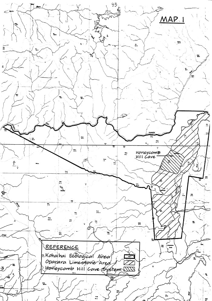
Map 1
4.2 Tourist Access and Concessions
The future management of Honeycomb Hill Cave system, to some extent, depends on the forest management in the Oparara Valley.
Access is currently via logging roads which would need to be maintained to a higher standard than at present if general tourist access to the Oparara is to be continued.
Planting in the valley has now ceased and indigenous logging using current techniques can only continue for a limited time in the future, at which stage the logging road would normally no longer be maintained to its present standard.
Upgrading of the road to allow ready tourist access to the Arches - Caves area may result in increased public demand for access to the cave, through tours.
Also to be decided is whether the Forest Service should continue its present role of ferrying tour groups from the public carpark to the cave's carpark and guiding them through the tourist route(s) or whether this would be better serviced by a concessionaire. The remoteness of the caves will be the determinant as to whether a concessionaire option is viable or not: the passing on of significant travel costs could well make the tour prohibitive.
The possibility of running "Adventure Tours" through the restricted access sections of the cave has already been raised. This would require few if any, structural modifications within the cave, but raises important questions regarding the need for controlling such use, and adequate protection of the cave's scientific values. Also, if such tours were to incorporate above-ground travel (over the karst) which is likely, these areas would almost certainly require tracking, especially if the tours were relatively frequent. The limestone karst areas are turned to bog by continual (not necessarily heavy) use.
The concessions issue revolves greatly around the type of tours and clientele aimed for. Adventure tours aimed at the "middle of the market" could engender a considerable amount of interest and activity. This could have the effect of making many New Zealanders including locals, reasonably familiar with the layout of the cave, making it impossible to restrict future access to the system, given the number of entrances. This would be an undesirable result.
If aimed at the "top end" of the market, thereby being more "exclusive" in nature, they may create pressure from the general public for greater access to these sections of the cave. Such pressure might also come from Forest Service personnel (or concessionaires) running the basic tour.
In conclusion, as you can see, the integration of development with conservation has resolved many of the conflicting issues. This must be attributed largely to the expert advice the department has sought and received. We appreciate that without this advice management of the cave would have been very different and certainly less successful. We look forward to this liaison continuing.
We have also raised what we would see as the major areas of concern for the future. Your comments today, and throughout this conference on these matters would be appreciated.
REFERENCES
CODY, A; K A WILDE and T WORTHY (1982): A Basis for New Zealand Cave and Karst Management. NZ Speleological Bulletin 7(124): 94-98
MILLENER, P R (1984): Honeycomb Hill Cave - A Survey of Scientific and Scenic Resources. National Museum of New Zealand. Unpublished report.
RAUTJOKI, H A and I MILLAR (1984): North West Nelson State Forest Park - Honeycomb Hill Cave: Management Plan. NZ Forest Service, Nelson: Unpublished report.
WILDE, K A (1984): Honeycomb Hill Cave System - Recommendations for Management - NZ Forest Service. Unpublished report.
WOOD, M (1985): Report on the Photomonitoring of Honeycomb Hill Cave 1984-85. NZ Forest Service Unpublished report.
WORTHY, TH (1984): Honeycomb Hill Cave System: A description of the cave, its structure and development with comments on its fauna both recent and subfossil. NZ Forest Service. Unpublished report.