PLITVICE : A CASE STUDY IN KARST MANAGEMENT
INTRODUCTION
Yugoslavia is justly famous for its caves and karst. Many of the pioneering studies of both karst phenomena (von Valvasor 1689, Schmidl 1854, Cvijic 1893) and cave biology (Schiner 1854) were carried out in that country. Such familiar terms as karst, doline, uvala and polje are all of Yugoslavian origin. Today over 10,000 caves have been documented, and although only some 24 caves or cave areas are open to the public, these account for a significant part of the country's tourist revenue (Habe 1977a).
It must be emphasised that the government, and hence the management of natural resources, is highly decentralised. The system of samo-upravljanje, or self-management, places the responsibility for each enterprise in the hands of the workers concerned with day-to-day operation, and under the constitutional amendments of 1974, this system was extended to community concerns and "non-productive" industries (see Davidson (1978) for a simple account).
This emphasis on localised management means that one cannot generalise about karst management, or indeed any other topic, from one part of the country to another. My own personal experience covered only parts of Slovenia and Croatia and some eight tourist caves or cave areas. The differences in management were certainly more apparent from cave to cave than the similarities, and Plitvice, the subject of this paper is vastly superior in management to all other areas which I visited.
Plitvice is a national park, but I am unable at this point to explain the relative responsibilities of central government, provincial government and local management. Of the tourist caves in Slovenia which I visited or of which I have knowledge, all are locally managed — six by tourist associations and six by caving clubs (Habe et al 1978).
Before proceeding to deal in detail with Plitvice it is perhaps worth referring briefly to the famous Postojna Cave. This has been visited consistently since at least the 13th century, was developed as a tourist cave in 1819, published its first guidebook in 1821 (the current edition, in six languages, is the 86th) and now is visited by up to 10,000 people per day (Habe 1977b). It is a huge and spectacular cave system, with many features of interest. Despite this and the very excellent guidebook, my overwhelming impression is that the major management objective is simply to maximise the number of visitors, regardless of any other considerations!
Finally in this introduction, I also emphasise my remarks on Plitvice are primarily based upon my own experience as a visitor over a three-day period. I have referred to the literature where possible, for descriptive information and statistics but, at this stage, have not been able to obtain details of or to discuss the management plan. Thus, in commenting upon such matters as management objectives I have made an assessment of the situation from the visible evidence of park development and not from formal documentation.
THE PLITVICE LAKES
The central feature of the Plitvice area is a series of sixteen terraced lakes within a forested valley. The lakes are, in themselves, a surprising feature in a karst area where most drainage is underground. They owe their existence to a complex of algae and mosses which act to precipitate tufa from the mineral-laden waters. This tufa both seals the lake bed and forms a series of walls between lakes, resulting in gradual deepening of the lakes and terracing of the total complex. (Bozicevic 1965, Pepeonik 1977, Vidakovic 1977.)
The total surface area of the lakes is some 192 hectares; the total distance from the beginning of the uppermost lake to the beginning of the Korana canyon below the lakes is between eight and ten kilometres; while the difference in altitude from top to bottom of the system is some 154 metres (Figure 4). These bold statistics give little idea of the remarkable beauty of the lakes themselves, each with its own distinctive colour in deep blue or green, and the various cascades between them.
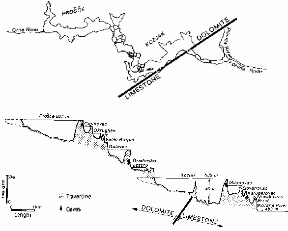
Figure 4: Plan and Profile of Plitvice Lakes, after Pepeonik 1977
It is important to recognise that this lake system is an environmentally sensitive one. The tufa barriers between the lakes are constantly eroded, yet simultaneously re-generated by new deposition. Thus, the preservation of the lakes is dependent upon continuity of the dynamic biological processes involved in the development of the barriers between the lakes, and this could very easily be disturbed by human influence (Pevalek 1958). I will return to this issue below.
In addition to the lakes and waterfalls, two kinds of caves occur in the valley. Some are the familiar caves found in the limestone bedrock, many of which have yielded important palaentological or archaeological material. More unusual are the caves formed within the tufa barriers between the lakes, not by the usual solution processes, but by the interaction of various forces at work in the construction of the barriers themselves. The surrounding forests also conceal literally many hundreds of dolines and uvalas.
THE NATIONAL PARK
Moves towards establishing a system for protection of the Plitvice Lakes Area commenced in 1890 and in 1893 a formal association was formed to further the safe-keeping of the region. Various moves were made to have the area declared a National Park and although this was first done in 1928, the legislation concerned remained in force for only one year. It was not until April 1949 that the present National Park was proclaimed and its present pattern of management and administration was only enacted at the beginning of 1970 (Vidakovic 1977).
The area of the Park as presently proclaimed is approximately 20,000 hectares. Of this area, some 13,500 hectares consists of more or less virgin forest with a magnificent diversity of flora and fauna. The remainder is farmland with a few villages, having a total population of approximately 2,000 people. These people are all engaged in park administration, provision of hotel or other services to visitors and in primary production for consumption by visitors.
Plans are in hand to extend the present park to a total of approximately 33,000 hectares. This extension will mean that the total watershed draining into the park will fall under park management and will prevent any actions which might adversely affect water quality or the preservation of the lakes.
Other than tracks for visitors, building developments are concentrated along the main road which fringes the park. These include three hotels all of extremely high quality, a petrol station, campground, two supermarkets, a high quality restaurant built in historic style and serving the traditional food of the region, and several other refreshment centres.
Visitors enter the park at any one of four entrances. Two of these are situated adjacent to major car parks and other services along the main road, while two others are adjacent to the hotel area. The entry charge is sixty Din (approximately $3.00). The visitor receives an attractive ticket which incorporates a map of the park and several photographs. This ticket entitles one to enter the park at any time over a two-day period and to use either the road train or boat which are available to transport visitors from one end of the park to the other.
The most recent figures which I have available on use of the park are provided below in Table I. However, I understand that there are today well over one-half million visitors per annum and the number is maintaining a steady increase.
Table I
| Year | Total number of registered tourists | Number of foreign tourists | Percent |
|
1970 1971 1972 1973 1974 1975 1976 |
247,193 305,137 262,344 328,782 332,635 407,793 395,515 |
143,000 179,600 159,605 203,056 197,852 226,357 204,149 |
39 59 61 62 60 56 52 |
N.B. Figures are only maintained for the period May 1st to September 30th each year. At other times of the year the low number of visitors does not justify staffing of entrances.
ASPECTS OF MANAGEMENT
As noted above, I do not know the formal management objectives established in the park plan. As a visitor it appears to me that the primary objective is probably something like:
To enable visitors to fully appreciate the beauty of the Plitvice Lakes Area.
Along with this, it is obvious that conservation is a very major factor in management. However, by contrast with most national parks in Western countries, there is no very overt attention to educational objectives. Nevertheless, as I will detail below, those visitors who wish to obtain educational information are readily able to do so to a much greater extent than is possible in most other parks.
Two of the most attractive areas of the Lakes are each within two hundred metres of a park entrance. A very large proportion of visitors, on the occasion of my visit, did not move any great distance into the park but were content to spend their time in these two remarkably beautiful areas. Some would enter at one of these areas, then catch either the road train or boat to the other and then return to their hotel or car.
Considerable attention has been paid to track-making. Those tracks on bedrock are paved with gravel, but all those which are upon or near the tufa barriers are constructed from split logs. On the whole the tracks are unobtrusive, but where this is not practical, they are attractively designed to fit in with the landscape. The split logs which are used provide a non-slippery surface, even in areas where they are continually wet.
The road train runs on a bitumen roadway and is virtually completely silent. The roadway itself runs for virtually the whole of its length through dense forest and is so constructed that it never intrudes upon one's view. Similarly the boat used on the Lakes is electrically operated and completely silent. It moves slowly enough to leave little wake on the Lake surface. The only other transport within the Park are several small horse-drawn buggies. A visitor may hire one of these for a specific journey and they are also used for patrol of the walking tracks. At least on occasion a patrolling ranger will give a ride to visitors whose enthusiasm has exceeded their endurance.
Park interpretation commences at the gateway. As one approaches a multi-lingual sign lists the key features of the Park:
SILENCEWATER
FORESTS AND WATERFALLS
My observation is that this is a particularly powerful piece of interpretation. I saw many parties of visitors approaching the gate as a noisy and excited group, yet within the park they walked about in much the same way as visitors to one of the great cathedrals. I did not see a person running about or sky-larking in any way within the park, even though there is no evidence of any authoritarian control nor are there any other signs enjoining proper behaviour.
The ticket is, in itself a valuable interpretative aid. In particular, it includes a map of the park. This and all other maps are colour-coded and the only signs within the park are small and unobtrusive finger boards with coloured dots relating to the colour-coding on maps. The visitor can also buy very cheaply a descriptive folder with a much larger and more detailed map; there is also an extremely attractive guidebook available together with various "coffee-table" picture books. Finally, those who want more educational information on the park are able to purchase the Management Plan together with a volume of the research papers upon which planning has been based. Regrettably, the latter two documents are only available in Serbo-Croatian, but all others are published in up to eight languages.
Both the boat and road train have an audio system which plays soft music interrupted occasionally by brief explanatory statements about the park. Again, these are multi-lingual.
The rangers play a relatively low key role. They are available near the entrances, assist with car parking and answer enquires from the public. One occasionally sees a ranger on patrol within the park and again their major function is that of answering enquires. Most speak several languages reasonably well and have at least some understanding of the other languages commonly used by visitors. The only uniform worn is the traditional folk costume hat - a beautifully embodied scarlet and black cap with a long tassel. Visitors who wish to do so can purchase their own ranger hat at either of the supermarkets.
The overall result of these management practices appears to be one of overwhelming respect for the resources of the park by visitors. I saw virtually no sign of damage or vandalism and the rangers told me that this is virtually confined to the car park and shopping areas at the fringes of the park. My own visit was at the end of the park pressure period during the European summer holiday season, but even with extensive searching along the pathways and under bushes, I could find no sign of litter.
Careful location of gates and design of paths also serves as a very effective zoning mechanism. Reference has already been made above to the extent to which the majority of visitors remain relatively close to park entrances. On one day I walked the total circuit of the Lake system and other than in the high density areas, saw only three people in the course of that walk. At the same time, there were probably some 10,000 - 12,000 visitors to the park on that day.
I would argue that the key to the remarkably impressive management of this park lies in the focus upon aesthetic appreciation, the extent to which this is implemented through virtually every aspect of park management, and the extent to which park management is internally consistent. It leads me to question many features of the park management which one commonly sees.
REFERENCES
BOZICEVIC, SRECKO. 1965. The Plitvice Lakes. Guidebook to Congress Excursion. IV Inter. Congress of Speleology, Ljubljana.
CVIJIC, J. 1893. Das Karstphanomen. Geogr. Abhl. 5:2l7-329.
DAVIDSON, BASIL. 1978. The Yugoslavs Begin to Wither the State. New Society. 46 (844): 575-575
HABE, FRANCE. 1977a. Fremdenverkehr der Karstgebiete in Jugoslawien. Proc. 6th Inter. Congress Speleology. Olomouc, Vol. 7, pp. 179-190.
HABE, FRANCE. 1977b. The Postojna Grottoes. Postojna Tourist and Hotel Enterprise.
HABE, FRANCE, et al. 1978. Show Caves in Slovenia. Karst Association for Environment Preservation, Postojna.
PEVALEK, I. 1968. (The Biodynamic of the Lakes of Plitvice and Their Protection) in Nacionalci Park Plitvicka Jezera, Zagreb.
PEPEONIK, ZLATKO. 1977. Plitvice Lakes as a Karst Phenomenon and as a Tourist Attraction. Proc. 7th Inter. Congress Speleology. Sheffield, pp. 339-342.
SCHINER, RUDOLF. 1854. Fauna der Adelsberger - Leuger - und Magdalenen- Grotte, pp. 231-272 in Schmidl, A., Op. Cit.
SCHMIDL, ADOLF. 1854. Die Grotten und Hohien von Adelsberg, Lueg, Planina und Laas, Braumuller, Wien.
VIDAKOVIC, PETAR. 1977. Plitvice Lakes National Park, Turistkomerc, Zagreb. (5th edition)
VON VALVASOR, J.W.F. 1689. Ducatus Carniolae tabula geographica ...