PROPOSED KATHERINE KARST NATIONAL PARK
For several years organisations and interested people have been promoting the establishment of a tropical karst national park in the Katherine region of the Northern Territory. To date there have been few tangible results and lack of community support. Additional investigations have been carried out in the area over the past 12 months to enable a submission to be made to the new Northern Territory Government which hopefully will result in the declaration of a substantial area incorporating the existing Sixteen Mile Caves Nature Park.
The Territory Parks and Wildlife Commission (formerly the Northern Territory Reserves Board) has strongly supported the proposal but its efforts have been thwarted.
The Commission is competing against many groups for land to be included in the parks and nature reserve system. In addition to the usual groups - mining, pastoral, agricultural, etc - all unalienated Crown land in the Territory is subject to Aboriginal land claims. At present the majority of the existing Territory national parks and reserves are subject to land claims.
The Commission has the responsibility to establish a national park system which includes representation of all the major ecosystems that occur in the Northern Territory. This will enable the protection and continued survival of the Territory's native flora and fauna. In addition to its conservation aims, the Commission is firmly committed to the provision of appropriate facilities and public access and the promotion of park use consistent with the national park concept.
The Commission also proposes setting aside reserves or national parks to protect: unique or endangered flora and fauna; special geological formations; and archaeological or historical sites. The area of the proposed Katherine Karst National Park includes features from each of the above categories.
The area under consideration is a small portion of the vast Daly River Basin (Figure 3). Within this Basin a cavernous rock formation known as the Tindall limestone covers an area in excess of 3 000 000 hectares. Extensive outcrops of Tindall limestone exist between the small Sixteen Mile Nature Park and Katherine Township. This area is of particular interest due to the large number of cave entrances known to exist, extensive dolines, tower karst and other karst features. The flora and fauna associated with this limestone is of considerable interest.
It is proposed that the boundaries of the existing 259 hectare nature park be extended north-west along the Stuart Highway to include the spectacular tower karst occurring 1.5 kilometres west of the highway adjacent to the Katherine Airport. The proposed park would continue west to enable the setting up of a tropical karst wilderness area of around 3 000 hectares.
The development and management of the existing park was covered in a paper presented to the last conference in Hobart. Over the past 12 months, consolidation of previous work has been carried out and most of the proposed park developments have now been completed. In brief, extensive redevelopment has been carried out and the park management has been directly taken over from a concessionaire by the Commission. The show cave, Cutta Cutta, has been set up for regular visitor inspections using a sophisticated, virtually concealed lighting system. The cave has been set out for public inspection with a minimum of intrusions on the cavescape: a hand rail in one short section; three sets of steps; five small switchboards; a limited number of spotlights and low bollard track lights. Guided tours, incorporating a short nature walk on the surface are conducted on a daily basis during the dry season by the two resident rangers. A small service and residential area has been set up on the park, out of view of the public. Two furnished log cabin homesteads have been constructed for the staff. The service includes a small office, store, workshop and powerhouse with two 25 kVa generators. All power, water and telephone reticulation lines on the park are underground.
Whilst the two resident rangers can normally cope with the guided inspections, park maintenance, pest control and routine work such as provision of fire breaks etc, there is little time for extensive survey and exploration work. Several surveys have, however, been carried out on the park and surrounding areas. These include one carried out by a team from the Australian Speleological Federation in May 1974 plus various surveys by Commission staff and other Northern Territory government personnel including botanists, biologists and geologists. To provide a reasonable data bank on the area's resources for the determination of future management and development objectives, considerable additional surveys are necessary. One major gap in our current knowledge is the location and mapping of cave entrances and prominent karst features plus further cave exploration. We would like to make arrangements with the Australian Speleological Federation and other groups to carry out some of this work.
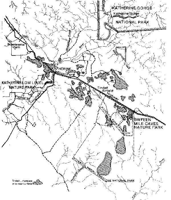
Figure 3 Proposed Katherine Karst National Park
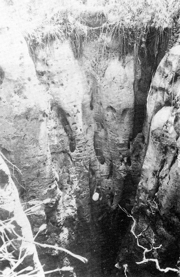
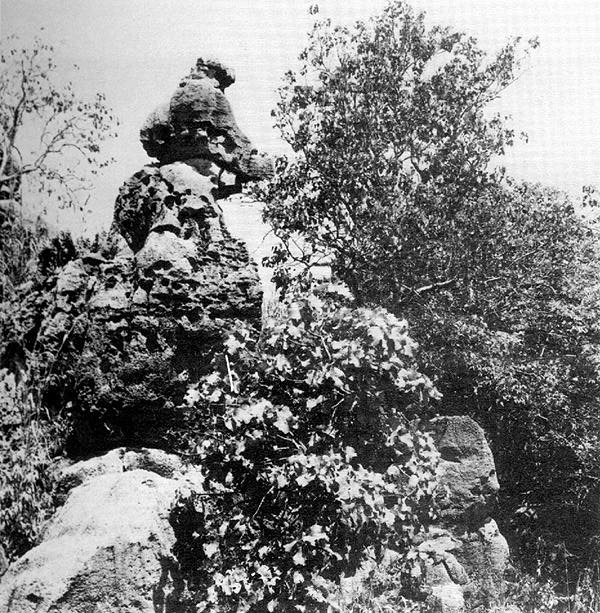
Vertical Pitch, Tower Karst
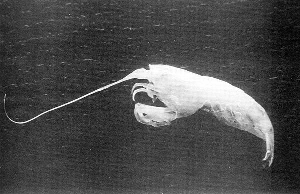
Sorghum Grass, Blind Shrimp
Mapping of the cave entrances is difficult due to the extent of area, the large number of entrances, the ruggedness of the terrain, the vegetation and the climate.
During the wet season (December to March, 600mm rainfall) movement on the ground can be difficult, if not impossible and by early February the dominant grass of the region, Sorghum (sorghum plunosuni), reaches a height of up to 4 metres and consequently restricts ground visibility. During the dry season, which is also the tourist season, visibility improves but other attractions or distractions such as the highly venomous King Brown snakes are quite active in the caves.
To assist future surveys, the Commission is supplementing National Mapping aerial photography with low-level 70mm infrared and colour photographs. A relationship exists between many cave entrances and large native fig trees which can be readily identified on the photographs. Helicopter surveys have also been used to confirm locations and identify features. It is planned that all resource data be fed in to the Commission's computer data bank for ease of access.
Some of the interesting information gleaned from investigations include the following:
Flora surveys have found that there are at least 3 species of Ficus in the area, though only one specimen of Ficus virens variety dasycarpa has been recorded in the region. It has been recorded in Western Australia and one specimen was reported in Arnhemland but this site has been lost.
The small colony of 5 Ghost Bats, Macroderma gigas, sighted in the Cutta Cutta Cave by the Australian Speleological Federation survey team in 1974 have increased to 15. The breeding cave for this species has not yet been located.
In July 1974, 'Guy' Cave K26 was surveyed and mapped by U.N.S.W.S.S.
This cave, which is approximately 2 kilometres west of the Cutta Cutta Cave, has an entrance 8 x 6 metres, a depth of 20 metres and a passage length in excess of 1 000 metres. During the past 3 wet seasons a large colony of Golden Horseshoe Bats, Rhinonicteris aurantius, have been using this cave as a maternity cave.
Another cave surveyed and mapped by U.N.S.W.S.S., the Turkish Bath Cave K30, is 300 metres from K26, with a length of 160 metres, an approximate depth of 10 metres and has an entrance temperature of 34°C
The Cutta Cutta Cave is the only known cave in the area where access to the water table is possible, though other caves probably exist in the proposed national park where such access is possible. Two species of eyeless shrimp from Cutta Cutta; Parisin unguis and Parisin gracilis have been identified. These shrimps have not as yet been recorded in other locations in Australia and other species of the same genus are known only from caves in Malagasy.
Dramatic doline collapses occur each wet season. During the 1976/77 wet, a vertical pitch appeared adjacent to the self-guiding Cutta Cutta Cave nature walk. This shaft was 1 metre across and 10 metres deep and led down to a funnel at the bottom. Another vertical pitch appeared recently within a few metres of the railway line and main highway 3 kilometres north of the park. This pitch is 8 metres across and 13 metres deep. Another 4 shafts have appeared adjacent to this large one, all of a similar depth but varying between ½ metre and 1½ metres across.
In conclusion, we seek your support in establishing this tropical karst national park.
I would like to thank the Australian Speleological Federation and the South Australian National Park Service for the opportunity to present this paper and in organising this conference