What is special about Australian Caves and Karst?
Optimal Karst Management – http://www.karstmanagement.com
Email: aspate1@bigpond.com
Abstract
Australia has 19 World Heritage Properties – many of these have karst-associated values. We had one UNESCO Global Geopark until it was torpedoed by stupid political ideologies. Australia has a program of recognising significant ‘national’ landscapes – again many of these have karst values and provide some recognition of karst.
There are other areas such as the Nullarbor limestone karst and wonderful sandstone karst and pseudokarst landscapes of northern Australia which are worthy of World Heritage or similar status which are again precluded from proper recognition by Australia’s political and cultural systems.
This paper reviews the karst areas of Australia in regard to their international and national significance. In keeping with the conference themes of ‘people, planet, profit’ comment will be made on what Australia’s karst resources offer the nation.
Introduction
In 1975 Joe Jennings published a paper titled How well off is Australia for karst and caves? A brief geomorphic estimate in which he suggested that the continent had a paucity of cave and karst features with only Tasmania approaching the situation in the rest of the world. Much has been added to our knowledge of Australian karst and caves since that time. Whilst Jennings’ estimate is still fundamentally correct, what has changed dramatically is that the values of these resources have achieved international and national recognition through instruments such as World Heritage listing. There are other important areas that have received little recognition or are poorly sampled in reserves.
This paper will review various types and levels of recognition and see how inclusive they are in recognising Australia’s karst and cave environments. Firstly what sorts of values can we now identify for our karst areas? Ken Grimes provides an overview with his map of Australian karst regions (Figure 1).
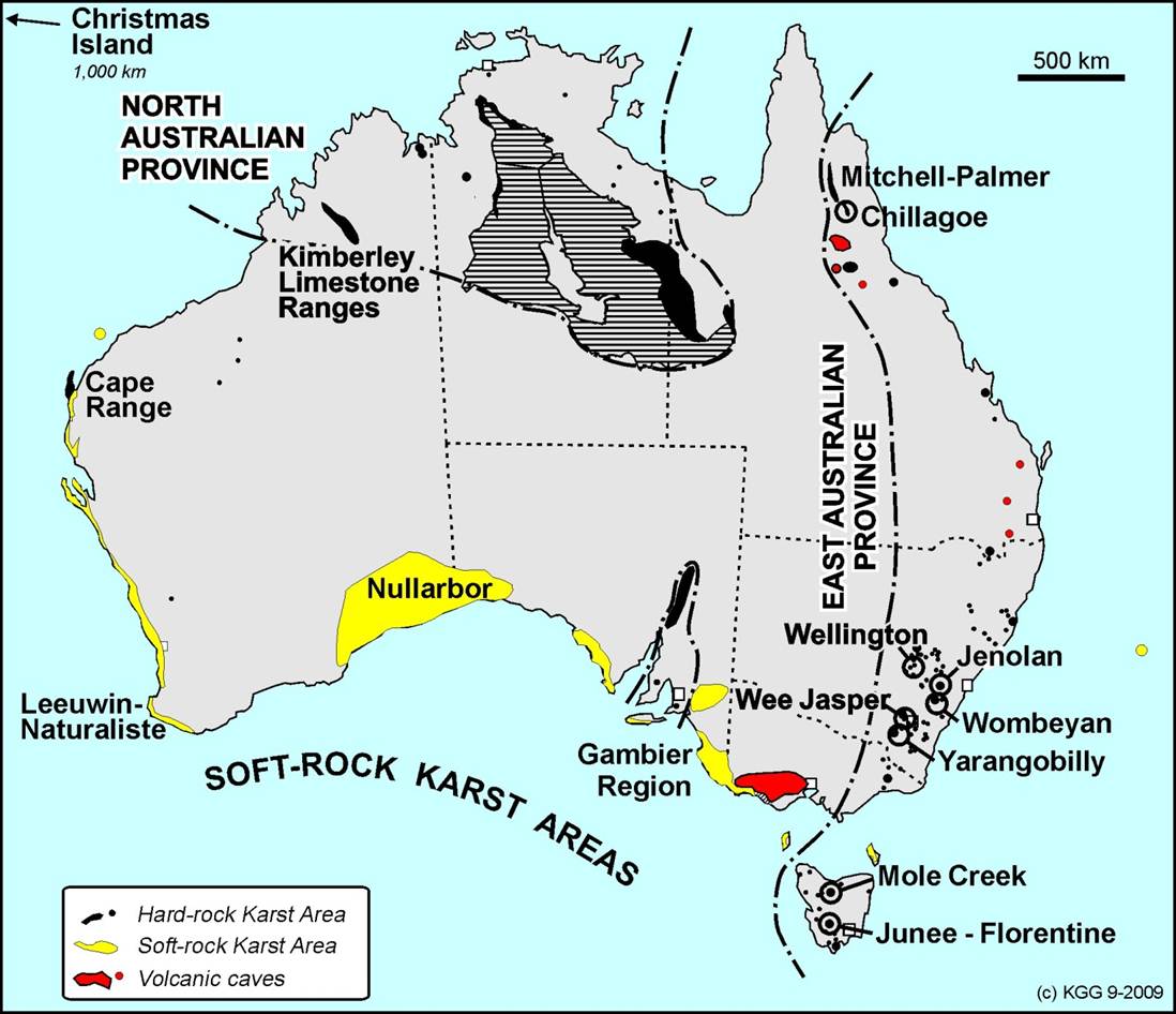
Figure 1. Australian karst regions (courtesy Ken Grimes).
Some of the values that can be ascribed to our karst, cave and pseudokarst resources include:
- Largest extent of young dune limestones in the world.
- Significant karst caves and landforms in many areas.
- Incredible antiquity of Jenolan and perhaps other caves.
- Significant rock art in both karst and pseudokarst caves.
- Remarkable palaeontological values.
- Largest semi-arid to arid limestone region in the world.
- Significant subterranean biodiversity.
- Significant pseudokarst caves and karst features in sandstone, granites and laterites.
- Spectacular and unusual scenery.
- Significant aquifer systems.
- Significant contribution to local economies through cave tourism and scenery-based tourism.
- Etc.
These values, in many cases, are within relatively well-protected and managed reserve systems although that coverage can be very patchy especially in karst regions such as those with the young dune limestones.
World Heritage properties
Australia has 19 properties inscribed on the World Heritage list in recognition of their “outstanding universal value”. Some of these are serial sites. These are shown on Figure 2 and their values, dates of inscription and the presence/absence of karst values are shown in Table 1.
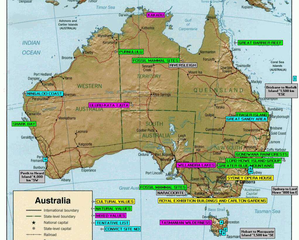
Figure 2. Australian World Heritage properties (note that the Ningaloo Coast and the Australian Convict Sites were in fact inscribed in 2010).
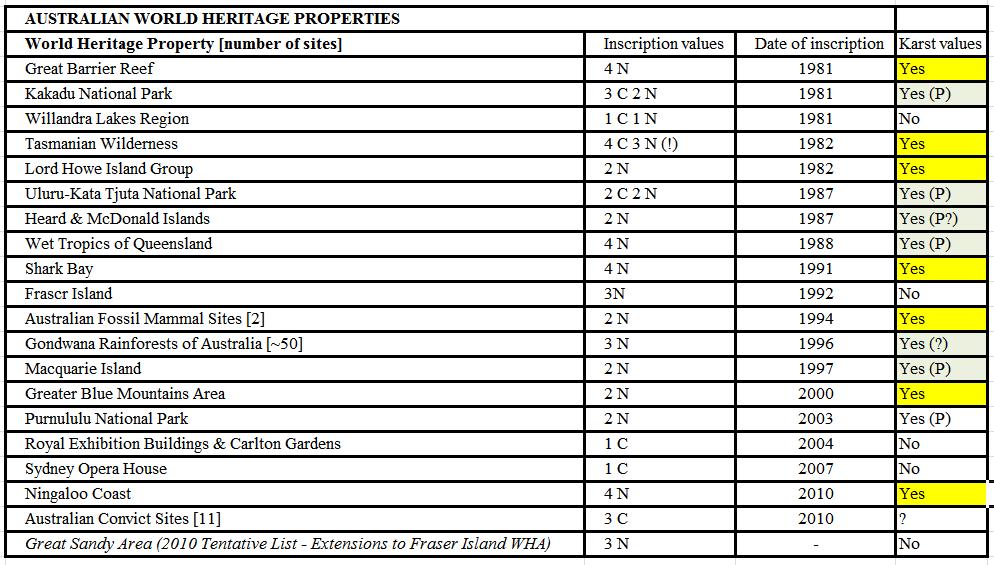
Table 1. Australian World Heritage properties and their values. Notes: N = natural values; C = cultural values; P = pseudokarst.
From Table 1 for the 19 inscribed properties it can be seen that:
- Seven have karst values.
- Five have pseudokarst values.
- One or more of the 50 or more sites in the Gondwana Rainforests of Australia property probably has karst values.
- There are probably lava (pseudokarst) caves on Heard Island.
- Stretching the point maybe - the old Fremantle Gaol (Australian Convict sites) has conducted tours of an underground labyrinth of tunnels used to obtain groundwater for the gaol!
Thus 14, perhaps 15, of the 19 properties have some connection with karst or karst-like landforms. What are these connections?
- Great Barrier Reef – the “blue holes” of Cockatoo Reefs and elsewhere (Figure 3).
- Kakadu National Park – karstic scenery and caves and cultural values associated with them.
- Willandra Lakes Region – none
- Tasmanian Wilderness – very significant karst and cultural values associated with caves.
- Lord Howe Island Group – caves and coastal karst landforms in Quaternary dune limestones.
- Uluru-Kata Tjuta National Park – pseudokarst features with associated cultural values.
- Heard & McDonald Islands – probable lava caves.
- Wet Tropics of Queensland – pseudokarst features such as the Mt Hypipamee Crater (Figure 4).
- Shark Bay – large solution features (probable dolines) and minor caves on Dirk Hartog Island. Coastal karst landforms.
- Fraser Island – none
- Australian Fossil Mammal Sites [2] –caves, relict caves and other karst features.
- Gondwana Rainforests of Australia [~50] –limestone karsts exist in the Macleay Valley and elsewhere.
- Macquarie Island – lava caves.
- Greater Blue Mountains Area – Jenolan Caves and many sandstone pseudokarst features.
- Purnululu National Park – the striking “beehive” and other pseudokarst features.
- Royal Exhibition Buildings & Carlton Gardens – none.
- Sydney Opera House – none.
- Ningaloo Coast – large range of caves and other karst features and very significant subterranean biodiversity.
- Australian Convict Sites [11] –man-made tunnels under the Old Fremantle Goal.
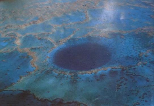
Figure 3. Blue Hole in Cockatoo Reef, Great Barrier Reef World Heritage Area.
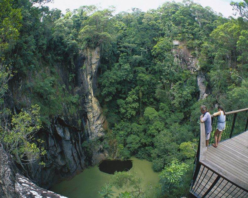
Figure 4. Mt Hypipamee Crater, Wet Tropics of Queensland World Heritage Area.
Ramsar sites
Other than World Heritage, how else may Australia’s karstic heritage be recognised? Of the 66 Ramsar Convention sites in Australia at least three have karst values. [The Ramsar Convention on Wetlands of International Importance … is an international treaty for the conservation and sustainable utilisation of wetlands. It is named after the city of Ramsar in Iran, where the Convention was signed in 1971]. Two of these are on Christmas Island (one may have been damaged by Howard’s detention centre); the other is Picanninie Ponds in South Australia.
Hosnies Springs is of particular interest. These are freshwater springs at the contact between the underlying volcanics and the over-lying reefal limestones of this rapidly uplifting island as it drifts north to the Wharton Trench. Here there are mangroves 30-40 m tall in freshwater at 24-37 m ASL (Figure 5). The Dales at the western end of Christmas Island are largely constructional features in tufa more dramatic than similar features on the mainland. Picanninie Ponds are quite different – upwelling freshwater in Tertiary limestone producing deep shafts – perhaps under the influence of rising carbon dioxide rich waters of uncertain origins at depth (Webb et al., 2010).
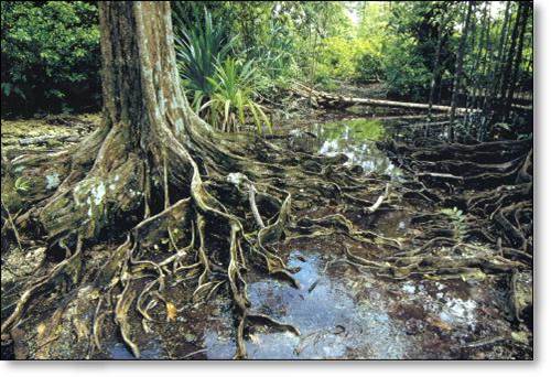
Figure 5. Hosnies Springs Ramsar site, Christmas Island.
Geoparks
The Kanawinka Geopark was recognised internationally as a UNESCO Global Geopark. The Network of Global Geoparks is based on the following criteria:
- To encourage understanding of Earth Science.
- To enhance sustainable management of resources.
- To provide education opportunities.
However, the concept seems much misunderstood by federal bureaucrats. The global status was withdrawn following representations from the Federal Government. To their great credit, the seven local governments in South Australia and Victoria have continued to support the Kanawinka Geopark. The Geopark contains 58 separate geosites in five precincts (Figure 6). Many of the geosites are karst features in the Tertiary and Quaternary limestones of this area.
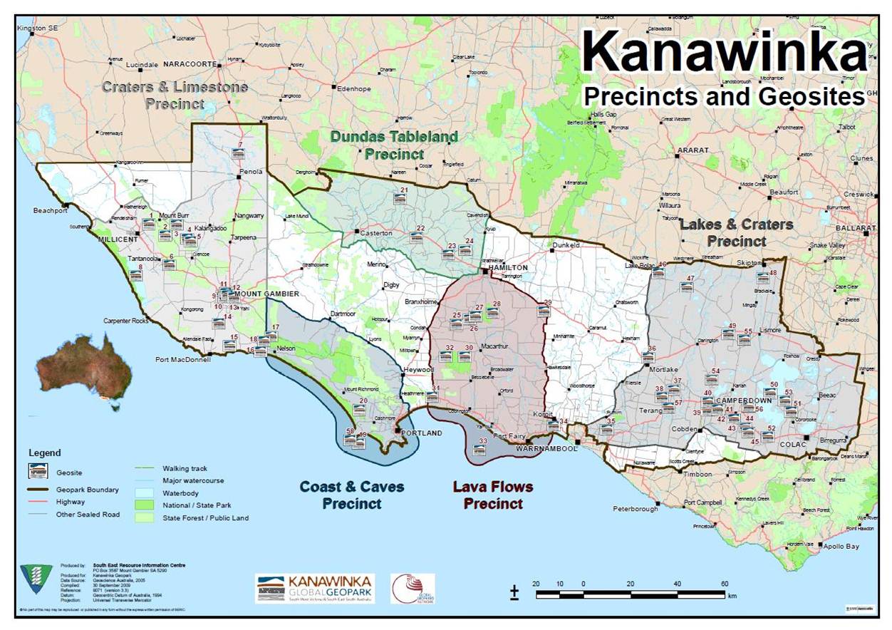
Figure 6. Kanawinka Geopark, South Australia and Victoria.
Other geopark proposals have been discussed in five states in addition to Victoria. It seems unlikely that these will proceed further at this time. A number of countries are currently establishing or have established national facilities (e.g. Brazil, Canada, Chile, China, Italy, South Korea) to develop geoparks and ultimately seek listing as UNESCO Global Geoparks.
Australian National Landscapes
Recently the concept of Australian National Landscapes has been developed largely by Tourism Australia and other interested parties. In the words of Bruce Leaver (pers. comm.) a national landscape “is an offer of a nature/heritage experience to a tightly defined target market with a characteristic profile. The first stage in NL roll out is a destination branding process that identifies the distinctive experience”. Sixteen national landscapes have been identified (Figure 7). Most of them contain World Heritage areas. The boundaries are deliberately “fuzzy” to define “an ‘experience boundary' and a site pleading to be 'in' or 'out' [is] only relevant if [it] contributed to the branded experience” (Leaver pers. comm.).
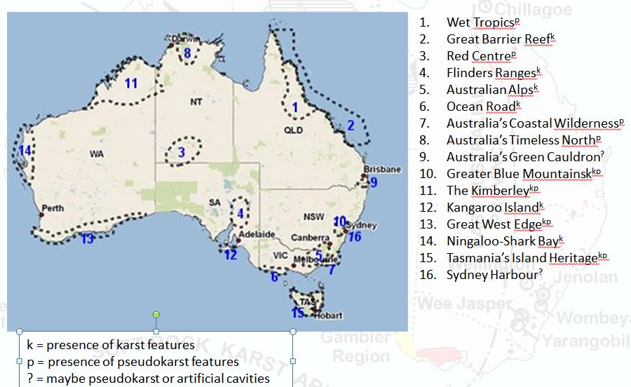
Figure 7. Australian National Landscapes (Tourism Australia website). Superscripts indicate the presence/absence of karst and pseudokarst.
Nation-wide assessment of Australia’s karst and pseudokarst
In 2006, the Heritage Division, within the then Commonwealth Department of Environment, Water, Heritage and the Arts formed the view that a simple and effective framework for the comparative analysis of karst values across Australia had not been developed. Geological and geomorphological approaches to enable comparative analyses had been developed by various authors, however, karst sites have not generally been considered holistically, for example the significant biodiversity values that are known for many karst areas have often not been considered, or have been overlooked.
A decision was made to hold an expert workshop to allow assessment of karst sites around Australia by identifying the most significant karst sites, their outstanding values and why these sites are of higher significance than other examples. Many of Australia’s karst scientists were invited to participate by preparing position papers on areas they considered important. These were discussed at a two-day workshop in Canberra and with remarkable unanimity 14 karsts were considered nationally significant (Figure 8). Many of these are within World Heritage areas, Australian National Landscapes or have Ramsar sites.
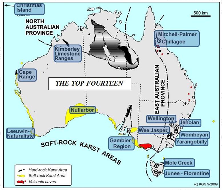
Figure 8. Fourteen karst areas identified as nationally significant by the Framework for Karst Values Workshop, Canberra, April 2006.
Discussion
It seems that Australian karst and caves are relatively well recognised by international and national instruments. However there are three aspects which arise.
Firstly, the Nullarbor karst has long been considered to be of “outstanding universal value” (e.g. Davey et al., 1992). Much of the Western Australian portion is leased for cattle grazing with a few areas of reserved land. Some of these reserves are quite extensive but important areas such as Mundrabilla Station are excluded. Due to the different land tenures and systems pertaining in South and Western Australia, it would seem that inscription of the Nullarbor as a World Heritage site is as long away as ever. It does not fit in with the concept of national landscapes.
Secondly, the Gregory karst should have been included in Karst Values Workshop considerations if only for the immense length of Bullita Cave with the thin Supplejack Dolostone (10-17 m, White and White, 2009). There probably would have been 15 nationally significant karst recognised if it had been discussed.
The third area for discussion is the remarkable range of sandstone karst and pseudokarst areas across northern Australia. Purnululu and Kakadu World Heritage Areas do not capture the full range and scale of the sandstone features. Many are “hidden” in Arnhem Land Aboriginal lands (Figure 9) but others such as the Abner Range (Northern Territory, Figure 9) and the Carnarvon Ranges (Queensland) could well make up an extended serial World Heritage nomination with Purnululu and Kakadu.
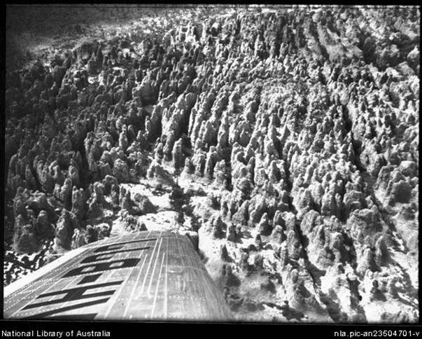
Figure 9. Ruined City, Arnhem Land (National Library of Australia).
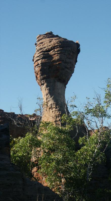
Figure 10. Sandstone pillar in the Abner Range of the Northern Territory.
Acknowledgements
I am grateful for the input of several delegates following the presentation at Waitomo particularly Dr Susan Q White.
References
Davey, A.G., Gray, M.R. Grimes, K.G., Hamilton-Smith, E., James, J.M., and Spate, A.P., (1992) World Heritage Significance of karst and other landforms in the Nullarbor Region, report to the Department of Arts, Sport, the Environment and Territories, Canberra.
Jennings J.N. (1975). How well off is Australia for karst and caves? A brief geomorphic estimate. Proceedings of the 10th Biennial Conference of the Australian Speleological Federation, Brisbane. pp 82-90
Webb J.A., Grimes K.G. and Lewis I.D. (2010). Volcanogenic origin of cenotes near Mt Gambier, southeastern Australia. Geomorphology 119:23-35
White S. and White N. (2009). Bullita Cave, Gregory Karst, N.T. Australia: A maze cave in Proterozoic Dolomite. Proceedings of the 15th International Congress of Speleology, pp 1010-13.