"Ecotourism" in two karst areas in Madagascar
Email: jmj@chem.usyd.edu.au 1 davidandsasa@bigpond.com 2 cbarnes6@bigpond.com 3
Abstract
The two internationally renowned karst areas of Madagascar are both plateau massifs in Jurassic limestone and have the distinctive weathered landscape of pinnacle karst, known locally as tsingy. The park’s magnificent landscapes together with their caves and exceptional biodiversity are ideal for ecotourism. However, the move to ecotourism in Madagascar in the 1990’s was made not for the above reasons but as the only real solution to managing and protecting threatened natural areas. To do this ecotourism trails funded by government and various international agencies were developed in both parks. Innovative infrastructure design and the use of local materials on the trails allows them to blend into the landscape. The trails of variable difficulty allow the entire spectrum of tourists to view landscapes and flora and fauna with minimal damage to their environment. Trained Malagasy guides, knowledgeable about culture and biodiversity, accompany all groups, further ensuring the protection of the parks. The parks and their surrounding areas benefit financially from the ecotourism either directly from park entrance fees or by employment generated by catering for the needs of tourists.
Introduction
In keeping with the conference theme of the triple bottom line, herein is a discussion of the development of “ecotourism” in the Tsingy de Bemaraha National Park and the Ankarana National Park in Madagascar (Figure 1).
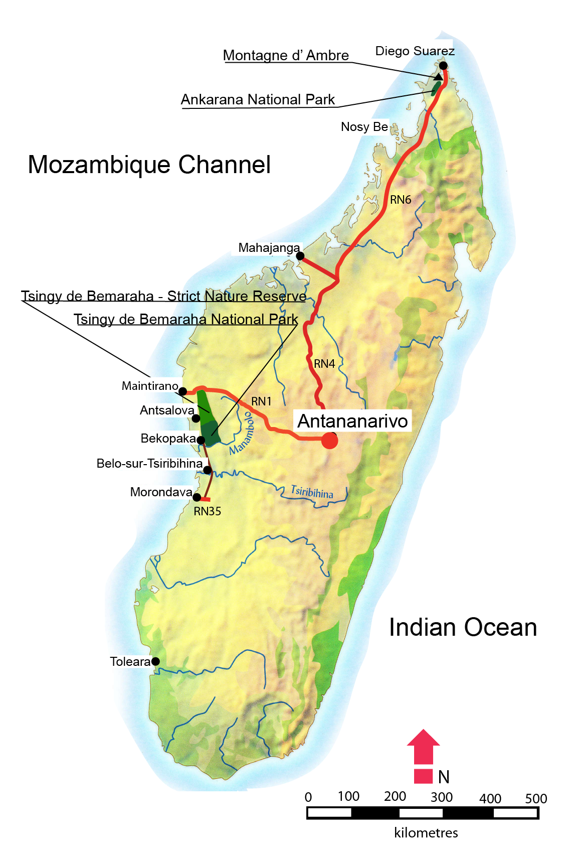
Figure 1: Location of the two National Parks in Madagascar (adapted from Grunewald and Wolozan, 2006).
There are many definitions of “ecotourism” the two presented below were obtained from McKay (1997).
Ecotourism is natured-based tourism that involves education and interpretation of the natural environment and is managed to be ecologically sustainable (Australian Department of Tourism, 1994).
The alternative and more fitting for this discussion is:
…low impact nature tourism which contributes to the maintenance of species and habitats either directly through a contribution to conservation and/or indirectly by providing revenue to the local community sufficient for local people to value, and therefore protect, their wildlife heritage area as a source of income (Goodwin, 1996).
A major attraction in both parks is a geomorphic feature known locally as tsingy (Figure 2). Tsingy is a karst surface covered with limestone pinnacles that in the tropical climate has fretted into razor sharp shards and spikes. There are four definitions of this Malagasy word: derived from the ringing sound the stone makes when struck (Middleton, 2004); derived from the Malagasy word for sharp (Bradt, 2011); a Sakalava guide claimed that the meaning was “walking on tiptoes”; another source claims the translation is “where one cannot walk”. Despite the ambiguity of its translation, it is used for terrains with pinnacle karst throughout Madagascar.
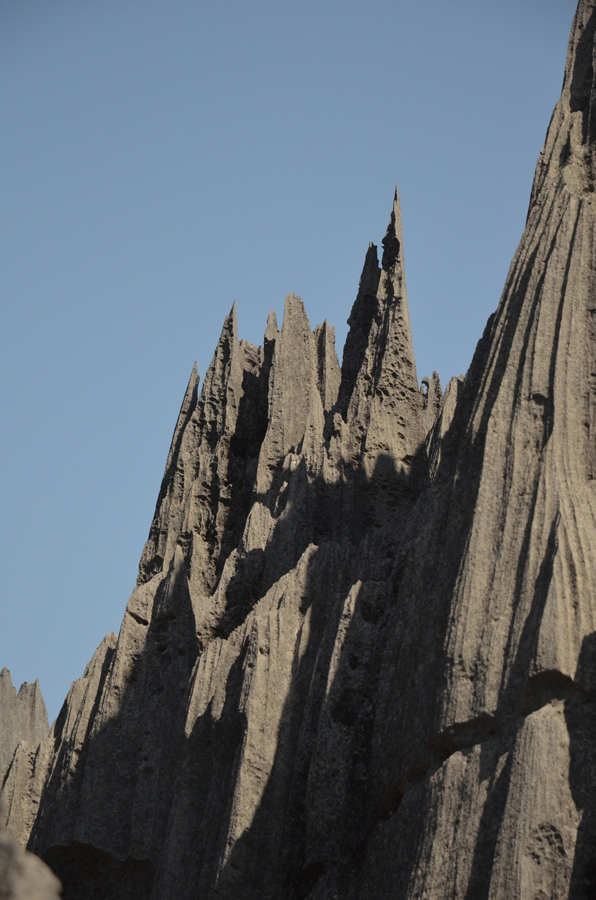
Figure 2: Tsingy.
Tsingy de Bemaraha National Park
In 1927, the entire Bemaraha Plateau, an area of 1520 km2 (Figure 1), attained a special level of protection when it was declared as The Antsingy de Bemaraha Strict Nature Reserve. By the 1980s, the limestone massif was at risk of deforestation as the result of slash and burn agriculture on its perimeter and in the easily accessed sections of the reserve. This forced the Malagasy government to undertake environmental action. Initiated in 1987, the heritage nomination process would see the Antsingy de Bemaraha inscribed as a UNESCO World Heritage site in1990, the first in Madagascar. As a result the area had a budget granted by government and various international agencies. A conservation program was commenced with the aim to protect the reserve while at the same time ensuring sustainable economic development of the surrounding areas. This was found to be insufficient because the Strict Nature Reserve status would not allow what was considered the only real solution for managing and protecting a threatened natural area, “ecotourism”. Hence, in 1994, the Tsingy de Bemaraha National Park was created allowing 725 km2 of the Strict Nature Reserve to become accessible to tourists. The new national park came under the direction of Madagascar’s National Association for the Management of Protected Areas (ANGAP). In addition, the two parks are administered by Madagascar National Parks.
Tsingy de Bemaraha National Park is difficult and expensive to access. The popular tourist route starts some 180 km to the south at Morondava (Figure 1). It is largely on unsealed roads with two ferry crossings of major rivers. At the south end of the park is the village of Bekopaka where there are fully serviced camping sites and hotels, while the park’s visitor center is located on the banks of the Manambolo River (Figure 1). The park offers eight developed ecotourism trails of varying levels of difficulty. All groups have to be accompanied by a local ranger/guide trained in ecotourism. Guides and tickets can be obtained at the parks visitor’s center. Part of the ticket price goes directly to the local community. The community also benefits from employment in the park and servicing the needs of the tourists.
The limestone of the Bemaraha is Jurassic and is composed of two layers of high purity and low porosity of the limestone that are separated by a more solution-resistant middle band of marly limestone, which takes longer to erode. The limestone has been dissected by the opening of a perfect joint maze to produce both caves and canyons. The upper and lower limestones both weather in the tropical climate to pinnacles, rock needles and spires - tsingy.
The park offers eight ecotourism trails. The Petit Tsingy trail provides good exposure for those afraid of heights and prone to difficulty with rough terrain. The "Grand Tsingy" group of trails start l7 km north of Bekopaka. The Andamozavaky trail, a full days’ excursion, is the cream of these. A journey through dense forests, canyons and caves, and up and down vertical walls is required to reach the top of the massif. On the top the trail wanders through spectacular tsingy, over forbidding precipices and onto stunning lookouts. The trail is a circuit and the descent from the top is equally stimulating. Safety is at a premium and climbing harnesses supplied by the park are required for this trail. It should probably be classed as adventure tourism. The Manambolo Trail starts as a canoe ride upriver to reach a Vvazirnba tomb and includes a decorated cave. Several of the trails close to the river can be combined, making a bivouac amongst the karst. There is only one developed trail in the north of the park, which caters for people entering Tsingy de Bemaraha from the village Antsalova, and has even less visitors.
The park’s trails were explored and developed for tourism by Jean-Claude Dobrilla. The paths blend into the landscape, camouflaged by the use of local limestone and wood cunningly bolted into place (Figure 3); no concrete was observed on the park’s circuits.
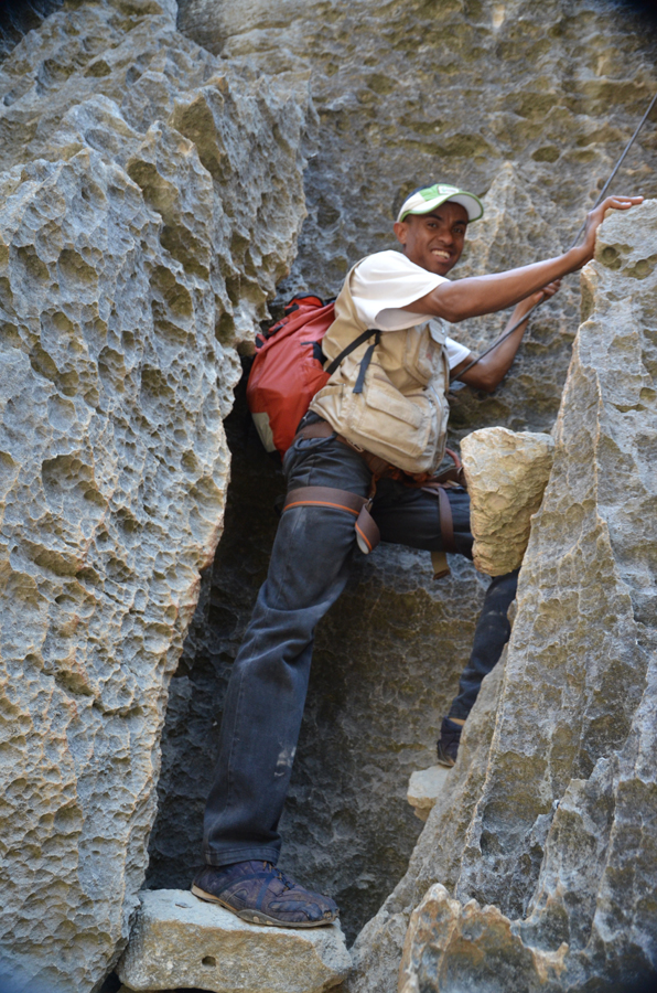
Figure 3: limestone blocks bolted into place as an aid to climbing
The park is closed to tourists for maintenance during the wet season from beginning of November to the end of April when approximately 1500 mm of rain falls and temperatures can reach 60°C. This frees some park employees to assist on family farms during the growing season.
Local guides speak a diverse range of languages, catering to the needs of most tourists. For example, one guide speaks English, French and also Japanese. The guides are exceptionally well informed about the local culture, competent with a discussion of biodiversity but are inadequately trained to discuss karst processes. Some guides have been trained in wilderness first aid. They diligently ensure that tourists do not deviate from the marked trails, so preserving the integrity of the fragile tsingy, and conserve the environment by picking up litter and preventing graffiti. The park is outstandingly clean.
Ankarana National Park
Unlike Tsingy de Bemaraha, that has an international reputation for its karst, Ankarana’s reputation lies in its caves. The Ankarana Special Reserve (Figures 1 and 4) was created in 1956. Prior to this the rugged relief and the dense vegetation had helped protect the region from extensive human intrusion. In 1986, a British expedition (Wilson, 1987) realized that the area faced an uncertain future, particularly as local deforestation had the potential to increase siltation in the caves and reduce the food supply for the cave communities. Intervention was required if the Ankarana Massif was to be safeguarded for the future. The Malagasy government at that time had the will, but sadly lacked the resources. In 1987 a film was made featuring the major attractions: the Crocodile Cave, the tsingy and the lemurs. As a result, in the 1990s money was raised from international conservation organizations and the area was protected for the benefit of karst wildlife, the people of Madagascar, scientists and cavers alike.
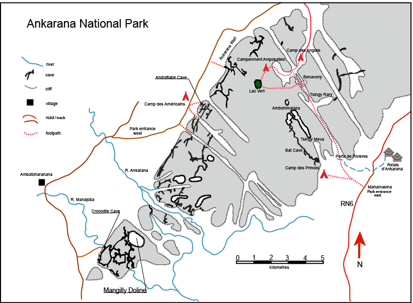
Figure 4: The Ankarana National Park (after Middleton, 2004).
As with the Tsingy de Bemaraha, ecotourism in the new National Park was able to produce additional funds for development and maintenance, and helped support the local community. The overthrow of the Malagasy government in 2009 saw the international conservation agencies depart, so currently the Ankarana National Park relies entirely on the revenue generated by ecotourism.
The Antakarana tribal group is predominant in Ankarana and its environmentally focused beliefs are beneficial to the conservation of the park. A third of the park entrance fee, together with donations given by tourists at sacred sites, are used to finance community development projects. A local committee administers the collective fund, with thirty-eight projects having been completed since 1992. Unfortunately, at present sections of the park are threatened by uncontrolled sapphire mining.
The Ankarana Special Reserve is 250 km2 and is a partially vegetated plateau composed of 150-million-year-old middle Jurassic limestone. The plateau slopes gently to the east but on the west ends abruptly in the Ankarana Wall, a sheer cliff that extends 25 km (Figure 4) and rises as high as 280 m asl. The limestone on the plateau has been etched into tsingy by the 2000 mm average annual rainfall. To the south the limestone massif is broken up into karst towers. In the centre of the plateau tectonic activity associated with the eruption of Montagne d’Ambre has faulted the limestone forming deep gorges. Rivers flow through the caves and are home to Nile crocodiles.
The Ankarana National Park (Figure 1) is on an arterial road RN6, located such that it draws day visitors from Diego Suarez 70 km to the north and from Nosy Be, a tropical paradise known as the Perfumed Isle, to the west. Such tourists do not necessarily have an ecotourism focus. This is in contrast to the Tsingy de Bemaraha where careful planning and a minimum of three days are required for a visit. However, accommodation at Mahamasina is available for tourists who wish to stay longer at Ankarana.
The advertised trails all start from the eastern park entrance on RN6 (Figure 4). Four of the walking trails start 2.2 km from the main road along a drivable track. All initially follow the same path, with junctions leading to the Perte de Rivieres (a massive sink of three rivers), the Tsingy Rary, Benavony Cave and Lac Vert (Green Lake). The Green Lake can also be reached by a longer 9.2 km trail. Another set of trails departs from Camp des Princes (Figure 4) to the Perte de Rivieres, the Tsingy Meva, the Ambohimalaza forest and the Bat Cave. The Bat Cave is over 4 km long and features a lower level with a river and an upper level that is well decorated.
The Crocodile Cave, portrayed in the 1987 film, lies to the south in a block of limestone separate from the main massif, and tours can be arranged to this cave from the park headquarters.
The west entrance to the park (Figure 4) accesses spectacular caves, including Andrafiabé Cave and Skeleton Cave, and several camping areas, including the well-equipped Camp des Américains. It is utilized by specialist tour agencies offering a different experience for those interested in more demanding trails and caves. However, a park guide is still required.
A day excursion to the Andrafiabé Cave and Skeleton Cave (Figure 4) from the east side of the park entails a long and arduous drive, hence a visit to these magnificent caves has to be somewhat truncated. Due to the preferences of tour operators park guides are less familiar with the western sections of the park, making visitation difficult.
At Ankarana, the trails have been developed with local materials in the same manner as those at the Tsingy de Bemaraha, the exception being one stretch of 165 concrete stairs leading down into the Bat Cave doline. In the caves infrastructure is minimal. The park does not supply helmets and lights for cave visits. Again the local guides have excellent language skills and are knowledgeable about culture and biodiversity, but have only elementary knowledge of karst processes in the park. The park is clean and free from litter and graffiti.
Conclusion
There is no doubt that ecotourism as developed in the two karst parks is a success. The change of half the park from Strict Nature Reserve to National Park has enabled the Tsingy de Bemaraha to completely fulfil all requirements of ecotourism: it is low impact, contributes to the maintenance of species and habitats and provides employment and revenue for the local community. Therefore it is sustainable. Ankarana, located within a more populous area and being accessible to a greater variety of tourists, provides different management challenges, however the presence of ecotourism does provide a multitude of benefits similar to Tsingy de Bemaraha with regard to conservation and sustainability.
Acknowledgements
The authors acknowledge many helpful discussions with the Madagascar National Parks Rangers and Guides and the assistance of Jean Jacques Fanina a “Malagasy guide extraordinaire” employed for our entire visit by the tour operator Undiscovered Destinations.
References
Australian Department of Tourism (1994). National Ecotourism Strategy. Canberra, Australian Government Printing Service.
Bradt, H. (2011). Madagascar. 10th edition, Bradt Travel Guides, UK.
Goodwin, H. (1996). In pursuit of ecotourism, Biodiversity and Conservation 5, 277-291.
Grunewald, O. and Wolozan, D. (2006). Tsingy - Stone Forest – Madagascar, Altus Editions, ISBN: 2-9526011-1-9.
McKay, B.M. (1997). Cave Conservation: is there a place for ecotourism? Graduate Diploma of Science (Environmental Science) thesis, The University of Sydney.
Middleton, G. (2004). Madagascar. In Encyclopedia of Caves and Karst Science, ed J. Gunn, Publisher, Fitzroy Dearborn, UK p. 493-495.
Wilson, J. (1987). The Crocodile Caves of Ankarana: Expedition to Northern Madagascar, 1986, Cave Science, 14(3), 107-119.