History and Long-term Conservation Management of Karst at the Vale of Belvoir, North-West Tasmania
Reserves Manager, Tasmanian Land Conservancy, Sandy Bay, Tasmania.
Email: dkingdom@tasland.org.au
Abstract
The Vale of Belvoir supports a unique mosaic of biological and geomorphological values, layered with a rich historical background. In addition to its extensive list of threatened flora, fauna and vegetation communities, the Vale is significant as one of Australia’s few subalpine karstlands.
The property was purchased in 2010 by the Tasmanian Land Conservancy (TLC), following on from a 150-year history of summer cattle grazing. The TLC is now managing the land for its conservation values, and is undertaking practical on-ground work in partnership with the community to research and conserve these values into the future.
Introduction
The Vale of Belvoir is a magnificent natural grassy valley in Tasmania’s highlands. The valley supports unique geological and geomorphological values and is one of only a few subalpine karstlands in Australia. The Vale of Belvoir also supports numerous threatened species and vegetation communities, and is recognised as one of the best remaining examples of Tasmania’s highland grasslands. In concert with the natural values, the valley has a rich historical background, including both indigenous and European heritage.
The Vale of Belvoir is located 8km northwest of Cradle Mountain, in Tasmania’s northwest. The Tasmanian Land Conservancy (TLC) purchased the 476 hectare Vale of Belvoir Reserve in 2008, in order to protect its many conservation values in perpetuity. The TLC manages the land as a private conservation reserve, in partnership with the community.
The Tasmanian Land Conservancy
The Tasmanian Land Conservancy is a private, not-for-profit conservation organisation, whose goal is to protect Tasmania’s biodiversity through conservation on private land. From the TLC’s beginnings in 2001, more than 50,000 hectares of private land have been protected. The TLC use a range of mechanisms to protect land, including the Permanent Reserves Program, which acquires land to be kept and managed in perpetuity by the TLC as private conservation reserves.
The TLC’s permanent reserves are funded through private philanthropic donations and, where possible, competitive grants. The TLC has also established a perpetual trust fund, to ensure an ongoing income stream to cover land management costs into the future. The Vale of Belvoir was the TLC’s eighth permanent reserve, which now has ten properties covering 3,500 hectares.
Natural values
The Vale of Belvoir Reserve supports a wide array of natural values, both biological and geological. The valley provides habitat for twelve threatened plant and animal species, and the highland grasslands are recognised by scientists as one of the best remaining examples of this vegetation community in Tasmania. The area also has some of the highest recorded densities of marsupial carnivores in the world, including Tasmanian devils, quolls and, at least historically, Tasmanian tigers.
The Vale of Belvoir also has a complex geology and geomorphology that is unique in Tasmania. The area is a limestone valley, partly infilled by basalt. Glaciation during the Pleistocene resulted in redistribution of the basalt and the transportation of dolerite erratics from Cradle Mountain. The area is recognised twice on the Tasmanian Geoconservation Database for its national significance, as Tasmania’s only example of a sub-alpine karstland and as a part of the Central Highlands Cainozoic Glacial Area.
The Vale of Belvoir is a highly active karstic landscape, with hundreds of sinkholes and numerous karst outcrops. Three new sinkholes have been recorded since 2008, focussed around two karst outcrops near the valley bottom.
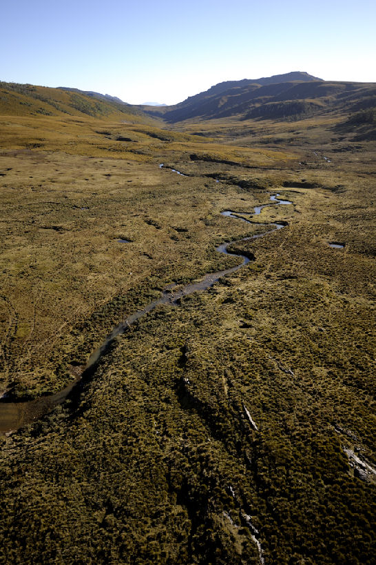
Figure 1: The Vale of Belvoir from the air. ©Matt Newton 2008
Sixteen caves have been mapped in the valley by local caving clubs and individual speleologists, and no speleothems have been recorded. The longest cave, ‘Fossey’s Slot’, measures 257m long and comprises a series of tunnels, including underground sections of a creek.
The karstic landscape at the Vale of Belvoir provides for unusual hydrological features. A mound spring was discovered at the Vale of Belvoir by Rolan Eberhard and Denna Kingdom in 2009, and is possibly the only sub-alpine mound spring in Australia. In addition, Lake Lea, to the north of the valley, is believed to flow in two opposite directions – to the north via the River Lea and to the south via the karst into the Vale River.
Management past and present
Evidence of Aboriginal occupation has been found in the region around the Vale of Belvoir, including domed bark huts and artefacts. These are supported by historical accounts by early European observations of Aboriginal tribes hunting, burning and travelling through the area.
The land now owned by the TLC was owned from 1897 to 2008 by a single family, who developed an extensive knowledge of the landscape and its seasonality. Their management of the area remained relatively consistent over this time, with mosaic burning of the grasslands at the end of winter and light cattle grazing during the summers. No pasture improvement or other development ever occurred, with the land used to supplement the family’s main farming practices at lower altitudes.
The TLC is continuing the management regime of the past 114 years, and is undertaking research to quantify the effects of the grazing and burning on the high levels of grassland diversity, and their role in the ecology of threatened plant species.
Before purchasing the Vale of Belvoir, the TLC investigated the specific conservation values of the valley and the real and potential threats to these values. An assessment was undertaken on how to manage these threats, and this assessment has formed the basis for the TLC’s current management plan for the reserve.
The greatest threat to the karst values of the reserve is nutrification and/or sedimentation of rivers and creeks upstream of karst. This is most likely to occur due to soil disturbance (pugging) and faecal input by cattle, and inappropriate fire regimes and vehicle use causing soil erosion.
Managing the impact of cattle is recognised as the highest priority for protecting the karst values. To do this, the TLC has instigated strict grazing lease conditions, which limit the maximum grazing intensity (0.3 cattle/ha) and specify the times of year that the cattle are permitted. The TLC has also installed fencing to exclude cattle from 24.5 hectares of sensitive wetlands, riparian areas and karst outcrops. Water quality is being monitored to assess any changes resulting from the exclusion of cattle from these areas.
Fire regimes and vehicle use are being managed in co-operation with the Parks and Wildlife Service, who manage the adjacent land. This includes the development of a fire management plan that will continue the mosaic burning patterns used over the past century, and the installation of signage restricting vehicle use for management purposes only.
To ensure that these threats are managed into the future, the TLC has also registered a perpetual conservation covenant over the land. This covenant restricts activities that may negatively impact the conservation values on the land. The covenant is registered on the land titles, ensuring that any future owners of the land are also bound by these restrictions.
Future management and research
Successful management of the karst at the Vale of Belvoir depends on our understanding of the areas past, and the processes that threaten or maintain it. Passing this understanding on to others who use or manage karst is also critical to ensure that other karstlands are protected.
The TLC encourages researchers to use the Vale of Belvoir to further our understanding of the caves and the history of the area. Opportunities exist for scientific research into palynology, palaeontology, cave biology and hydrogeology. The TLC also seeks research partnerships that will provide information to assist the TLC and others to manage this landscape.
Sharing our knowledge of the Vale’s values and threats with the community is also important. The TLC is looking to develop interpretation and education materials about the Vale of Belvoir, for general public use. Our volunteer program also provides opportunities for individuals to visit and work at the Vale of Belvoir, allowing us to share our knowledge of the landscape in-situ. By focussing on engaging and retaining long-term volunteers, these individuals also develop a deeper understanding of the area, which they can also share with others.
Conclusion
The Vale of Belvoir’s array of biological and geological conservation values are unique in Tasmania. The TLC is working to further our understanding of these conservation values and the processes that threaten and maintain them, in order to ensure their protection for generations to come.
Acknowledgements
Thanks to: the conference convenors for the invitation to attend and present; Keith Corbett for providing the geology map; Matt Newton for his stunning photography; and Rolan Eberhard for assistance in identifying karst values and threats to these at the Vale of Belvoir.