‘It is an alluvial soil, and capable of being drained’: the perilous integrity of Dismal Swamp
Honorary Associate, University of Tasmania
Email: lakelea22@yahoo.com.au
Abstract
Surveyor John Helder Wedge clambered knee-deep through wet swamps while searching for grazing land in the Circular Head region in 1828. Dismal Swamp, one of a few intact poljes known in Tasmania today, formed part of the swamp area on Wedge’s map which he believed could be profitably drained. Like the nearby Mowbray, Montagu, Welcome and Brittons Swamps, Dismal was a favourite habitat of blackwood (Acacia melanoxylon) timber — a staple of the Circular Head sawmilling industry for more than a century. When logging began in Circular Head, swamps were synonymous with disease, degradation and fear of the primeval. Clearing them represented not just financial profit but social justice. Precambrian dolomite swamps were logged and never regenerated, since agricultural land was needed for yeoman farmers and post-World War II soldier settlement. Only Dismal Swamp survived Wedge’s quest for pastoral supremacy.
Introduction
Dismal Swamp, one of few intact poljes known in Tasmania, owes its reservation to Smithton District Forester Wes Beckett. The swamp’s survival before Beckett’s intervention in the 1960s was just as remarkable, given the pressure exerted to log, drain and cultivate the dolomite swamps west of Smithton. The Circular Head-Arthur River region is rich in karst features, including the State-reserved Trowutta Arch; Lake Chisholm, a nationally significant sinkhole lake; and the Julius River underground stream and decorated caves (Lake Chisholm and the Julius River features are managed in Forestry Reserves by Forestry Tasmania).1 Graziers and vegetable producers had little interest in karst geomorphology, however, beyond the rich dolomite soil and the gushing mound springs it produced. Sawmillers were grateful for the swamp drainage regimes that created optimum conditions for the growth of blackwood (Acacia melanoxylon), a staple of the Circular Head timber industry. Unlike adjacent swamps, which were deforested, drained and therefore never regenerated, Dismal Swamp was only selectively logged, allowing its blackwood timber to return and its unusual geomorphology to be preserved by a dedicated forester.
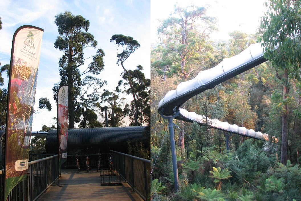
(Left) eucalypts soar over the Tarkine Forest Adventures (Dismal Swamp) visitor complex. (Right) The white-knuckle slide experience deposits the visitor on the floor of the Dismal Swamp polje. Photos by Nic Haygarth
For Tasmanian governments looking for new settlement areas, the far north-west has sometimes been embraced as the place of last resort. So it was at the beginning of European settlement. In 1825 the Van Diemen’s Land Company (VDL Co) was established under a royal warrant to grow fine wool in Van Diemen’s Land (later Tasmania) for the European market. When the company’s officers arrived in the colony in 1826, they discovered that Lieutenant-governor George Arthur was not pleased to have them here. Rather than giving them the fine pasture they expected, Arthur shunted them into the far north-west of the island where the company would not interfere with land selection.
When the VDL Co complained that it could find little grazing land in this portion, in 1828 Arthur sent the surveyor John Helder Wedge to explore the country.2 Wedge was soon wallowing in the Montagu Swamp south of what would become the VDL Co’s Woolnorth block:
Wednesday 26 [March, 1828]
To Swamp—mid leg deep in water. Thick Tea Tree and Sedge obliged to sleep on the tops of the Bushes—during the night I found myself lying at an angle of 20 degrees. Head downwards.
Thursday 27
Swamp Knee deep in water—wet night—Some of the men slept on the trunks of fallen trees, keeping themselves from falling into the water by stakes, and I slept on a small mound caused by a tree having given way and raised its roots above the surface of the water, with stakes to keep myself from rolling in…
Friday 28
Out of Swamp to forest—light Soil—Stringy Bark & Myrtle—Wet day and night.3
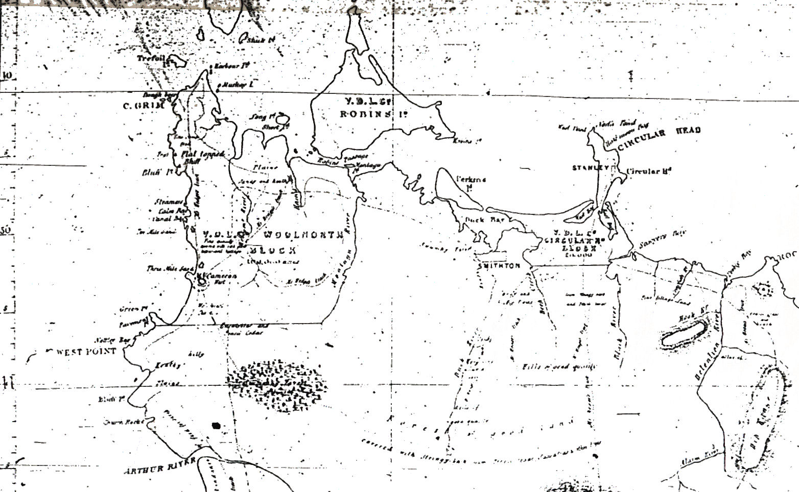
Far north-western Tasmania, as surveyed by JH Wedge in 1828. The Montagu, Dismal and Welcome Swamps are denoted generally by the dotted area south of the Woolnorth block. Map reproduced from Pat Brown’s book, From Montagu Swamp to Togari.
Wedge claimed that at least 40,000 acres of grazing land was already available to the VDL Co. Even the swampy forest had an alluvial soil and was ‘capable of being drained’. Another 700,000 acres, representing ‘some of the most valuable land in the Island’, lay beneath forests which Wedge invited the company to clear, defraying their expenses by exporting the timber, mostly ‘pencil cedar’ (blackwood), a beautiful native timber ranging in colour from light golden-brown to deep brown, sometimes with a reddish tint or black streaks.4 Extensive logging operations were not a welcome prospect for a grazing company.
However, it was good news for Arthur. In January 1829 he and his entourage rode northward from Hobart, through the Mole Creek karst into the far north-west, where he saw for himself the country and the forests the VDL Co was faced with.5 The success of Arthur’s meeting with VDL Co agent Edward Curr can probably be judged from the fact that the company took up the Woolnorth block explored by Wedge, and that within three years Curr was trumpeting the ornamental properties of blackwood. Curr regarded it as far superior to imported cedar, and recommended it for making furniture.6 He regularly requested blackwood from the Woolnorth property for the company’s own building purposes, and by 1839 believed the timber would command ‘an extensive market at a high price’.7
Having learned to appreciate other north-western assets besides sheep pasture, the VDL Co was encouraged by Polish amateur geologist Paul Strzelecki’s 1841 analysis of the mound spring at Deep Creek, at the western end of its Circular Head block near present-day Smithton. Strzelecki recognised ‘a slight indication of lime’ in the ‘aperient and tonic’ waters, concluding that ‘they are also sufficiently disgusting to the palate to pass for highly medicinal’.8 Curr optimistically imagined that Strzelecki’s opinion of the spring would attract ‘a great deal of attention’.9
Circular Head did not become a health spa. In fact the VDL Co fared so badly from the 1840s that the company became an absentee landlord in the years 1852 to 1869, letting its properties.10 Potatoes and blackwood were the stock in trade of coastal farmers at settlements like Montagu, but for decades few penetrated the forested tiers.
The timber industry starts to clear the swamps
By 1886 Joseph (JS) Lee operated the fastest, most sophisticated, steam-operated sawmill in the colony at a settlement called Blackwood Mill (now Leesville), west of Smithton. It was said that Lee’s timber resource reached from there ‘to the shores of the Southern Indian Ocean between West Cape and the debouchment of the Arthur [River]’.11 Lee was soon attacking the blackwood on the edges of the Mowbray (or Blackwood) Swamp and later the Montagu Swamp, enabling pioneer farmers to select holdings on the denuded land. By 1890 the VDL Co was exporting blackwood timber to England.12 In 1901, Thomas Just, in the Cyclopedia of Tasmania, recommended blackwood for the construction of railway carriages and trucks, coaches, felloes (the outer sections of wheels, to which spokes are attached), agricultural implements, furniture and cabinet work and for use in telegraph poles. In addition, blackwood produced fine staves for barrel making.13 By 1907 other companies like Britton Brothers had found their own blackwood stands on the dolomite swamps west of Smithton.14
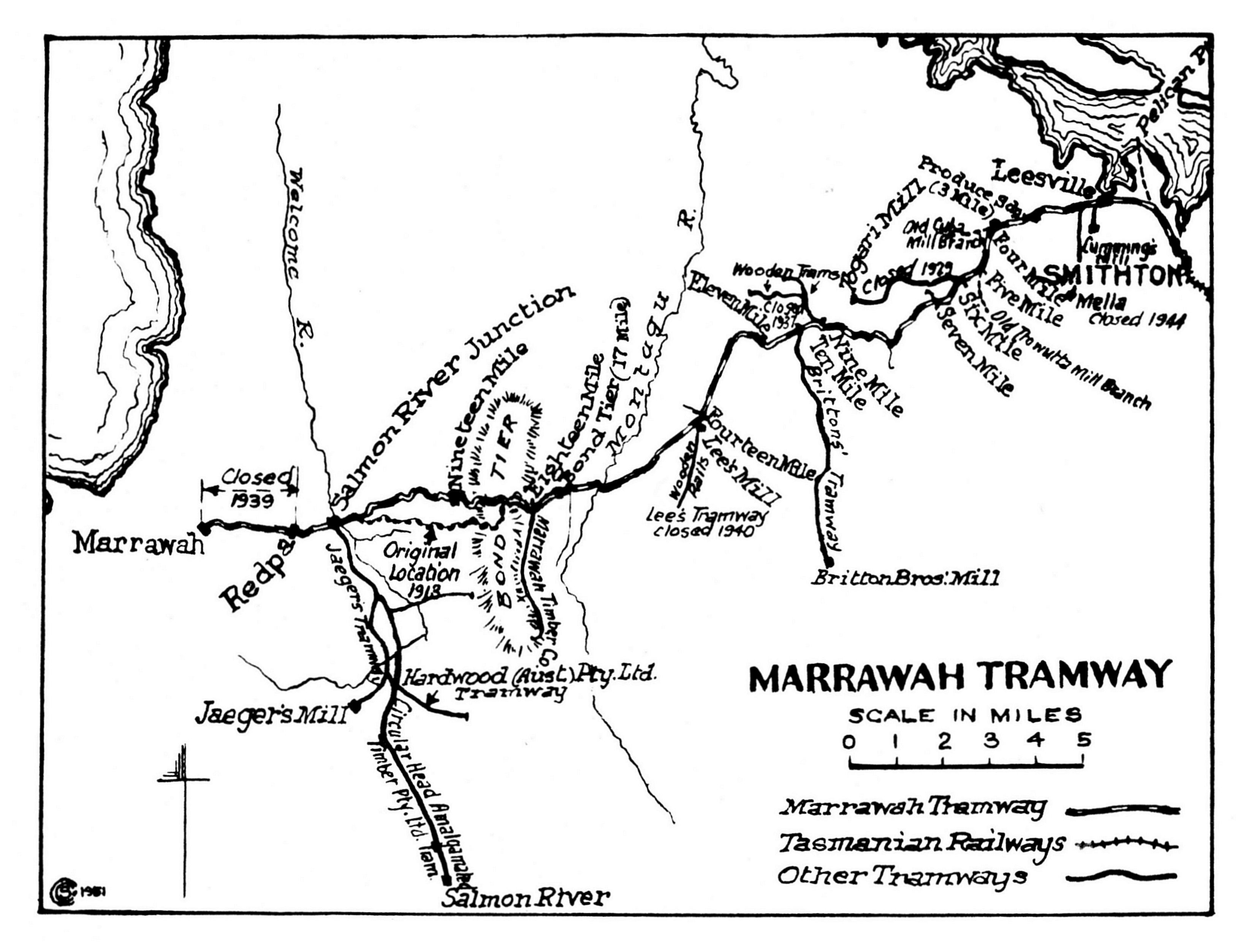
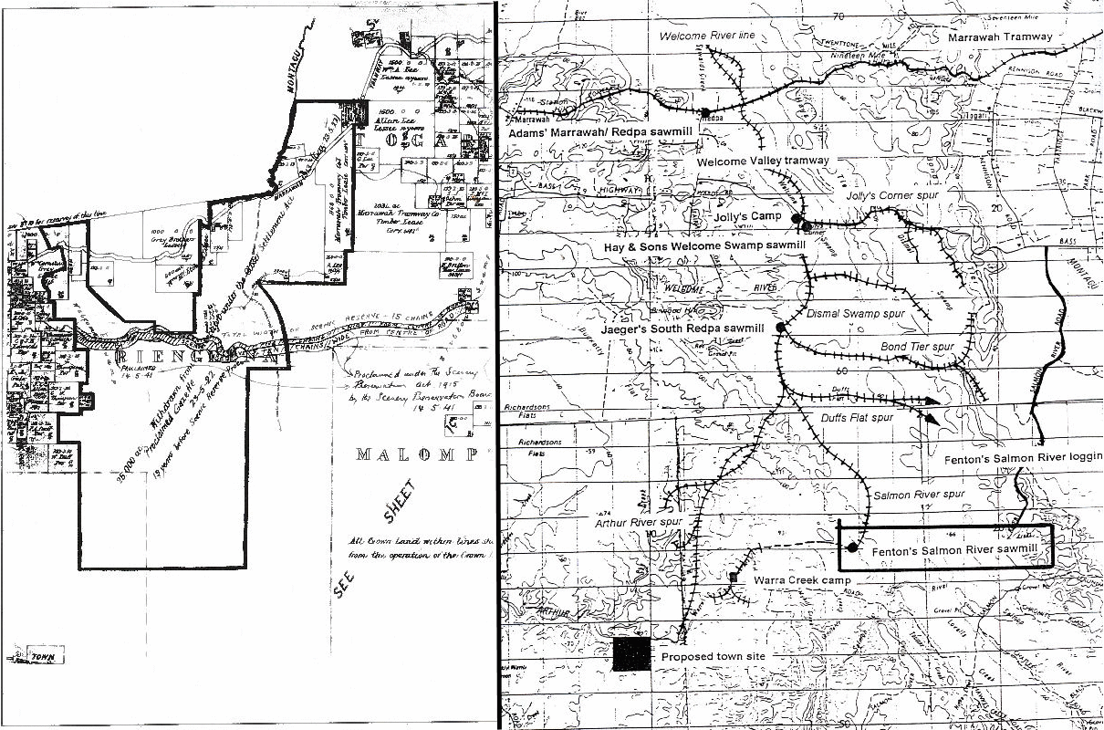
The Marrawah Tramway enters the dolomite Mowbray and Montagu Swamps on its journey from Smithton to Marrawah. Brittons’ branch tramway penetrates Brittons Swamp. Dismal Swamp lies between Bond Tier and Jaeger’s tramway, under the notation ‘Original location 1918’. Map from ‘Wanderer’, ‘Railways and Tramways of the Circular Head District’, Australian Railway Historical Bulletin no.168, October 1951.
A Britton Brothers wooden tramway across swamp lands Courtesy of the Britton family
The Marrawah Tramway was started by JS Lee in order to harvest the timber on the Mowbray Swamp. The State Government took it over and extended it to Marrawah on the west coast, and private timber tramways radiated from the Marrawah Tramway into the Montagu, Brittons, Arthur River and Welcome Swamps.15 The rapaciousness of the Circular Head timber industry was captured in Bernard Cronin’s novel Timber Wolves, published in 1920, the year before the establishment of the Tasmanian Forestry Department in an effort to make the industry sustainable.16 In 1925-26, 6 million super feet of blackwood sawlogs, most of them from Circular Head, were cut in Tasmania. The result of glutting the market for blackwood and eucalypt was a severe downturn in the industry, with rationalisation of Circular Head timber operators being investigated even by the middle of 1926.17
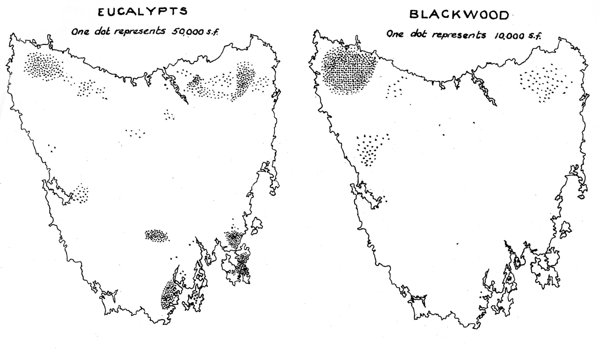
Circular Head (far north-west) is shown to be a significant eucalypt producer and Tasmania’s predominant blackwood producer in 1926–27 (from Acting Conservator of Forests, Forestry Handbook, Tasmanian Forestry Department, Hobart, 1928).
Draining the ‘dismal’ out of the swamps: the moral imperative
Swamps have been dismal at least since the Romantic period in literature and art. Peter the Great, tsar of Russia, for example, is said to have drained ‘dismal swamps’ to create St Petersburg, his ‘window on Europe’, in 1703.18 Perhaps the best-known Dismal Swamp in the world was in North Carolina, and in the mid to late 19th Century it was apparently a lawless place of lynch mobs, runaway slaves and criminals. In 1856 it featured in Mrs Beecher Stowe’s novel Dred: A Tale of the Dismal Swamp, and a stage version of this book toured Tasmania on several occasions. Similarly, in 1887 imperial explorer and journalist Henry Stanley famously marched through a ‘dismal swamp’ in darkest Africa, a place of perpetual gloom.19 It was not only physically but morally oppressive, since slavery was still practiced there. Late in the 19th Century, typhoid epidemics were still common in Australia through poor sanitation, being almost a rite of passage for a new mining town. The fear remained that disease was spread by ‘miasma’ (swamp gas) and rotting vegetation, providing a moral imperative to rid the world of swamps. In British culture a boggy road was typically described as a ‘slough of despond’ and a boggy forest was a ‘dismal swamp’.
For example, venturing over the tier from the settlement of Montagu into Montagu Swamp, in December 1878 District Surveyor Charles Sprent’s party emulated Wedge’s trials 50 years earlier:
We camped on a dry sandy ridge and to our dismay found the place swarming with mosquitoes. Very little sleep visited us that night and we were glad enough to be off next morning. However our troubles were only commencing, for we immediately got into the worst place I have seen in the colony. A great dismal swamp of tea, blackwood, bauera, cutting grass and all manner of abominable scrubs and in addition the place was knee deep in water. We tumbled about in the slop for nearly three hours and then came out on a patch of button grass, a most abominable slop. The grass concealed great water holes and into these we kept tumbling, one after the other up to our knees in water, we must have fallen fifty times going a quarter of a mile.20
A 1954 CSIRO map shows the relative positions of the Welcome, Dismal and Montagu Swamps, plus the Marrawah Tramway and Bass Highway. Brittons and the Mowbray Swamp are further east. Map from Pat Brown, From Montagu Swamp to Togari.
Another thing that made forested swamps dismal was that they isolated the settlers trying to conquer and exploit them. In 19th- and early 20th-century Tasmanian stories were common of bush selectors having to ringbark and burn trees on their properties because there was no means of getting the timber to market. One Brittons Swamp settler had the novel idea of burying the trees he felled, only to be exhausted by the exercise.21 The closeness of the forest, which blocked out both the landscape and social interaction with those living close by, was oppressive.
Social justice was also put to work on the dolomite swamps west of Smithton. From about 1820 to 1831 Tasmania created effectively a landed gentry by granting large acreages to pastoralists. From the middle of the 19th century, however, when the Victorian and New South Wales gold rushes drained Tasmania’s vigorous young male population, more was done to encourage the yeomanry to stay or to return to Tasmania after seeking their fortune. A series of Waste Land and Crown Land Acts contained provisions designed to open up the bush, and it was as a result of this westward spread of settlement that many caves were discovered in the Mole Creek region, including the tourist caves Scotts, Baldocks, King Solomons and Marakoopa. Early in the 20th century, there was further pressure for a fairer society, and the first Closer Settlement Act (1907) was designed to break up the big estates into small farms and sell them to yeoman farmers, but also to open up new areas of the bush.22
|
Smithton dolomite swamp |
Cleared & drained |
Legislative agent |
|||||||||||||||||||||||||||||||||||||||||||||||||||||||||||||||||||||||||||||||||||||||||||||||||||||||||||||||||||||||||||||||||||||||||||||||||||||||||||||||||||||||||||||||||||||||||||||||||||||||||||||||||||||||||||||||||||||||||||||||||||||
|
Mowbray (Blackwood, Mella) |
1904–06 1913+ |
Crown Land Act (1904); Closer Settlement Act (1913) |
|||||||||||||||||||||||||||||||||||||||||||||||||||||||||||||||||||||||||||||||||||||||||||||||||||||||||||||||||||||||||||||||||||||||||||||||||||||||||||||||||||||||||||||||||||||||||||||||||||||||||||||||||||||||||||||||||||||||||||||||||||||
|
Welcome |
1922-27 |
Closer Settlement Act (1913); Drainage Promotion Act (1917) |
|||||||||||||||||||||||||||||||||||||||||||||||||||||||||||||||||||||||||||||||||||||||||||||||||||||||||||||||||||||||||||||||||||||||||||||||||||||||||||||||||||||||||||||||||||||||||||||||||||||||||||||||||||||||||||||||||||||||||||||||||||||
|
Brittons |
1933-38 |
Closer Settlement Act (1929) |
|||||||||||||||||||||||||||||||||||||||||||||||||||||||||||||||||||||||||||||||||||||||||||||||||||||||||||||||||||||||||||||||||||||||||||||||||||||||||||||||||||||||||||||||||||||||||||||||||||||||||||||||||||||||||||||||||||||||||||||||||||||
|
Montagu (Togari) |
1953+ |
(Commonwealth) War Service Land Settlement Act (1945) |
|||||||||||||||||||||||||||||||||||||||||||||||||||||||||||||||||||||||||||||||||||||||||||||||||||||||||||||||||||||||||||||||||||||||||||||||||||||||||||||||||||||||||||||||||||||||||||||||||||||||||||||||||||||||||||||||||||||||||||||||||||||
Mowbray Swamp was opened up by selectors and by two government drainage schemes. In 1910, while cutting a drain through his peaty soil, the recently arrived potato grower Ernest Carrington Lovell made the first of his two discoveries of Nototherium (Pleistocene megafauna) bones.23 In 1931 a Mowbray Swamp selector claimed that there were 31 miles (50 kilometres) of underground drains on his property.24 Lionel Gregory, now 94 years old, dug drains on a Mowbray Swamp property during the early 1930s. He recalled digging 15 feet (almost five metres) below the surface. One man would shovel dirt out of the bottom of the drain up to a ledge, where a second person would shovel it up to the surface. He remembered the clover growing so high on the swamp that prone cattle were invisible amongst it.25 A traveller passing through the swamp on the Marrawah Tramway in 1929 marvelled at the ‘improvements’, quipping that ‘today the “dismal” has gone’.26
The Smithton Dolomite swamp’s natural waterworks intrigued locals. The ‘limestone blows’ were said to be among the milder of these gushing springs.27 They were traced across Mowbray Swamp by their accompanying mounds, some of these six metres high. Although some blows were considered toxic, cattle gained more joy from them than Strzelecki had from the spring at Deep Creek, reputedly enjoying this particular water so much that they would seek it out.28
Surveyors’ reports of the country west of the Christmas Hills echoed those of Wedge three-quarters of a century earlier. Miles (1902) and Carroll (1906) met ‘deep swamps’, ‘worthless’ land and bauera scrub.29 Still, the successful Mowbray Swamp drainage brought an influx of Victorian selectors and by 1921 had convinced the government to drain the Welcome, Montagu, Brittons and Arthur River Swamps. The Surveyor-general stressed the importance of reclaiming
a large area of swamp lands, now lying in useless waste, but which when reclaimed and opened up will form one of the largest and best agricultural and dairying propositions in the state.30
Disappointment followed. The development of the Smithton Dolomite Welcome Swamp near East Marrawah (Redpa) was a comparative disaster. Drainage was inadequate, the scheme was extremely expensive, and superintendent of the works, Thomas Strickland, faced accusations of foul play. Strickland resigned with the job incomplete after being criticised by a Royal Commission into the reclamation scheme.31 For years afterwards no land on the Welcome Swamp was ploughed.
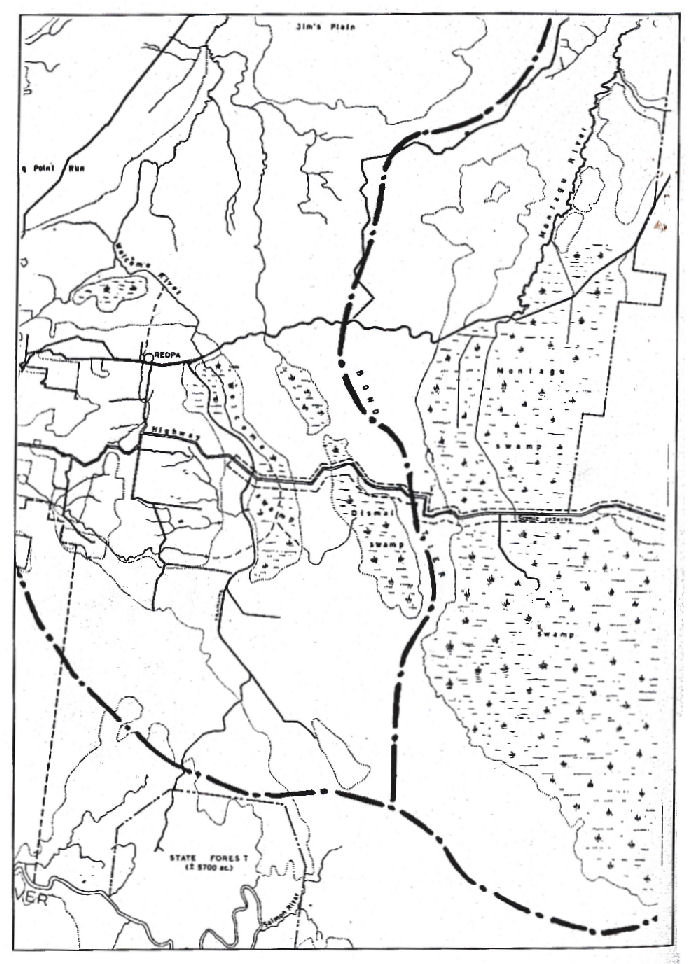
(Left) In 1922 Dismal Swamp was included in an area withdrawn under the Closer Settlement Act (1913) as part of the development of Welcome Swamp.32 The scheme failed and Dismal Swamp was never drained. (Right) During the 1930s logging tramlines crossed Dismal Swamp (near centre of map) from adjacent sawmills. Left map from Pat Brown, From Montagu Swamp to Togari; right map cropped from one by Parry Kostoglou, Regional Forest Agreement.
The Welcome Swamp scheme brought sawmilling to Dismal Swamp. The Marrawah Tramway Company established a sawmill, huts and steel-railed branch line from the Marrawah Tramway to harvest a reputed six million feet of blackwood in the area, but the contract was abruptly cancelled in the wake of the Royal Commission.33 This company may even have applied the name ‘Dismal Swamp’, which appeared on a Forestry Department map in 1925.34 By 1936 FD Hay and Sons and Frank Jaeger operated mills with branch tramlines into Dismal Swamp.35
New impetus for swamp drainage came from the demand for new farming land and construction of the main road from Christmas Hills to Marrawah during the early 1930s. Engineer Lewis East, of the Victorian Rivers and Water Supply Commission, provided guidance on swamp clearance.36 The Circular Head Chronicle hoped and expected ‘that every swamp in Circular Head will be brought under grass within the life of persons now living’.37 Even the sawmiller Elijah Britton, after whom the swamp was named, eventually agreed:
There was a difference of opinion on the opening up of Brittons Swamp. Some thought it should be kept as a timber reserve to grow blackwood, but after much thought Dad thought it was too valuable as grass land to be held for timber reserve.38
An additional moral incentive for developing this scheme was to provide unemployment relief during the Great Depression.39
Agriculture or forest regeneration?
While demand for sawlogs dropped during the Great Depression, another line in blackwood remained buoyant: staves for beer barrels. Britton Brothers, for example, fed Tooth’s Brewery’s insatiable demand for staves. These came from good quality cross-cut timber, split into various lengths. Stacks of staves were removed from the bush on horse-drawn sledges, railed or driven to the port of Stanley, then shipped to Sydney to be shaped by coopers in order to house Australia’s favourite drop. Much blackwood was wasted by cutters, however, disgusting the sawmillers.40 Just as millions of blackwood staves had been cut from the Marrawah tramway, the new road opened up Dismal Swamp as a tent town of stave cutters—taking only the best timber.41
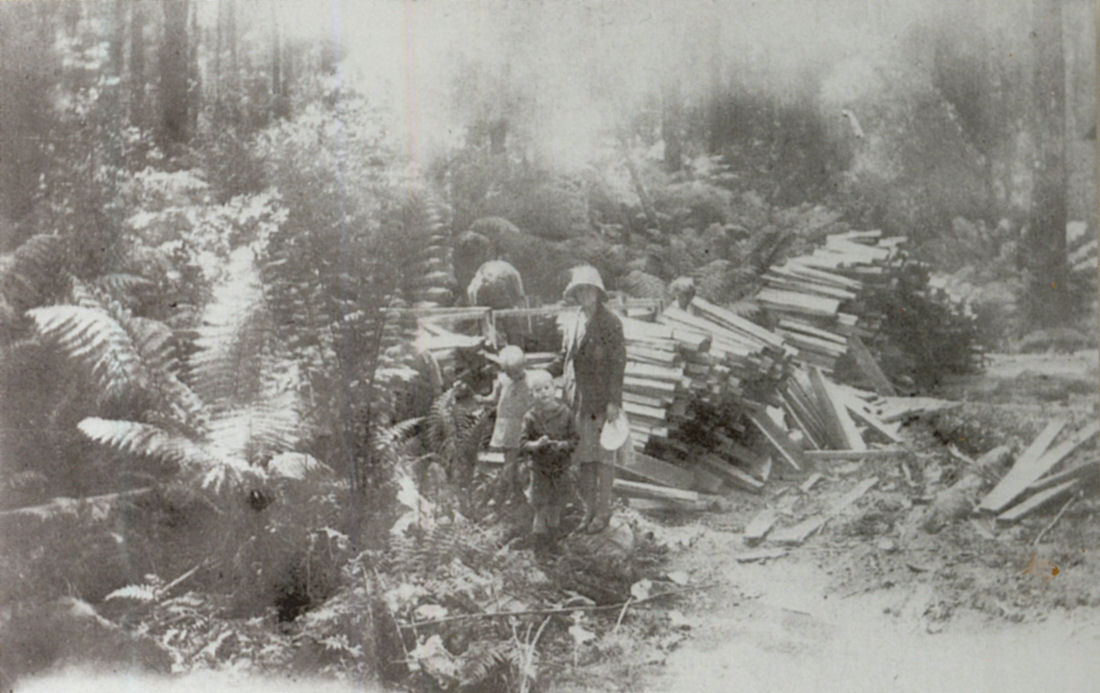
Blackwood sawmiller Eljah Britton (bent over at back) and Britton family members with a stack of blackwood staves waiting to be transported out of the bush, probably during the 1920s. Courtesy of the Britton family.
Yet Elijah Britton’s ambivalence about the future of Brittons Swamp expressed the tension existing between forestry and agriculture in the region. Closer settlement of the swamps ensured that after being cleared of millable timber they were never regenerated. Moreover, established bush selectors wanted cut-out timber leases for agistment of stock, not regeneration, and blamed adjacent forestry reserves for putting them at risk of bush fire.42 The announcement of a proposed forestry reserve on ‘swamp country’ near the Arthur River excited the response that:
it seems that the Forestry Department could not find a more suitable place to establish its reserves than in a farmer’s paddock. For what is the Far North West, if not the remaining last paddock of agricultural Tasmania?43
In 1938, after the failure of closer settlement at Welcome Swamp and Roger River, the Forestry Department’s AH Payne judged that ‘the success of agriculture on the high land appears to be very doubtful’, and warned that forest management and protection of the high land was needed.44
Social justice, in the form of soldier settlement, again interfered in the Forestry Commission’s conservation plans. As part of World War 2 (1939-45) resettlement, from 1953 part of the Montagu Swamp was drained and turned into a farmland region known as Togari.45 Millable timber was removed prior to the scrubbing and burning of the land. The demand for blackwood staves had, meanwhile, almost disappeared as demand grew for a cold one. The wooden cask would not withstand the additional pressure required to keep cold draught beer carbonated. Nor could a wooden cask be sterilised, and this led to the development of the stainless steel cask in 1950.46 At that time, Hobart’s Cascade Brewery had a stockpile of blackwood staves that would last it 20 years.47
While the blackwood stave trade disappeared, by the 1960s Circular Head sawmillers were looking to the county south of the Arthur River (a region now known as the Tarkine) for a new timber supply. North of the Arthur, an agreement was reached to open flat swamp land containing mostly blackwoods for settlement, while keeping the higher swamp lands containing mostly eucalypts for forestry purposes.
Accordingly, and through the efforts of Wes Beckett, Dismal Swamp was declared a Forestry Reserve in 1976.48 Ninety-seven hectares of that Forestry Reserve plus three additional hectares were gazetted as a State Reserve in 1979.49 In 1982 Dismal Swamp was placed on the Register of the National Estate ‘especially for its natural scientific interest’, noting ‘the need for some continued logging to retain that scientific interest’, that is, recognition that blackwood growth is stimulated by disturbance.50 The sculpture of a cow nonchalantly grazing the floor of the regenerating polje today is a neat reminder of the disturbance that Dismal Swamp narrowly avoided.
References
- See Chris Sharples, Karst Geomorphology and Values of the Tarkine: Limestone, Dolomite and Magnesite Karst Systems of the Arthur-Pieman Region of Tasmania: a Report to the Australian Heritage Commission and the Tasmanian Conservation Trust Inc, Hobart, 1997, pp.39-42, 44, 136-37.
- For an overview of the Van Diemen’s Land Company’s negotiations with Arthur and exploration see CJ Binks, Explorers of Western Tasmania, Mary Fisher Bookshop, Launceston, 1980.
- John Helder Wedge, The Diaries of John Helder Wedge 1824-35 (eds Mr Justice Crawford, WF Ellis and JH Stancombe), Royal Society of Tasmania, Hobart, 1962, 26-30 March 1828, p.46.
- JH Wedge, ‘Official Report of Journies by JH Wedge, Esq, Assistant Surveyor, in the North-West Portion of Van Diemen’s Land, in the Early Part of the Year 1828’, reprinted in Venturing Westward: Accounts of Pioneering Exploration in Western and North Western Tasmania by Messrs Gould, Gunn, Hellyer, Frodsham, Counsel and Sprent [and Wedge], Government Printer, Hobart, 1987, pp.36 and 39. In the 19th Century, ‘pencil cedar’ usually referred to blackwood (Acacia melanoxylon). Sometimes it was used to describe a type of Acacia melanoxylon distinct from ‘blackwood’ and ‘lightwood’, and it was also sometimes used to describe King Billy pine (Arthrotaxis selaginoides). There are several accounts of Lieutenant-governor Arthur’s trip to north-west Tasmania in 1829. See, for example, ‘Van Diemen’s Land’, Hobart-Town Courier 7 February 1829. For Arthur’s negotiations with Curr, see CJ Binks, Explorers of Western Tasmania, pp.89–90.
- Edward Curr to James Richardson 30 October 1832, VDL23/5 (Tasmanian Archive and Heritage Office).
- Edward Curr to Adolphus Schayer 2 September 1839, VDL23/8 (Tasmanian Archive and Heritage Office).
- Count Streleski [sic], ‘Notes of an Excursion in the North-western Part of Tasmania’, Tasmanian Journal of Natural Science, Agriculture, Statistics etc, vol.1, 1842, p.77.
- Edward Curr to Court of Directors of the Van Diemen’s Land Company 2 March 1841, VDL5/6 (Tasmanian Archive and Heritage Office).
- ‘Eighteenth Annual Report of the Van Diemen’s Land Company’, Courier 22 September 1843 p.4; ‘Van Diemen’s Land Company’, Courier 18 August 1852, p.4.
- Theophilus Jones, ‘Rural Tasmania: no.16’, Examiner 7 January 1888, supplement, p.1.
- See, for example, Minutes of VDL Co Court of Directors 16 July 1890, VDL201/1/10 (Tasmanian Archive and Heritage Office).
- Thomas Just, ‘Timber Trees and the Timber Trade’, Cyclopedia of Tasmania, Maitland & Krone, Hobart, 1901, vol.1, p.468.
- Nic Haygarth, Celebrating a Centenary of Britton Timbers: Tasmania’s Blackwood Dynasty, Britton Timbers, Smithton, 2007.
- ‘Wanderer’, ‘Railways and Tramways of the Circular Head District’, Australian Railway Historical Bulletin no.168, October 1951, pp.151–52.
- Bernard Cronin, The Timber Wolves, Hodder & Stoughton, London, 1920.
- ‘Tasmanian Timbers Ltd’, Circular Head Chronicle 21 July 1926, p.5.
- Fred T Jane, The Imperial Russian Navy: its Past, Present and Future, W Thacker & Co, London, 1899, p.51.
- Henry Stanley to the Emin Pasha Relief Committee 28 August 1888; quoted in ‘The Story of Stanley’s Great March’, Mercury 13 May 1889, p.3.
- Charles Sprent’s notes of Montagu Swamp trip December 1878; quoted by Bob Mesibov, ‘The Dismal’s Interesting Story’, Circular Head Chronicle 25 November 1987, p.4. See also ‘District Surveyors’ Reports’, Mercury 7 June 1879, p.3.
- Lorna Britton notes, held by the Britton family.
- Shayne Breen, Contested Places: Tasmania’s Northern Districts from Ancient Times to 1900, Centre for Tasmanian Historical Studies, Hobart, 2001, pp.42–46.
- See, for example, ‘Interesting Discovery’, Examiner 9 August 1910, p.5; ‘Nototherium Oweni Mitchelli’, Mercury 7 April 1920, p.3. For an overview, see Edmund D Gill and Maxwell R Banks, ‘Cainozoic History of Mowbray Swamp and Other Areas of North-Western Tasmania’, Records of the Queen Victoria Museum, Launceston, new series no.6, 1956.
- ‘Brittons Swamp: Public Works Committee Inquiry’, Circular Head Chronicle 16 September 1931, p.1.
- Interview with Lionel Gregory 10 October 2010.
- ‘Scout’, ‘By Train to Marrawah’, Circular Head Chronicle 10 April 1929, p.4.
- ‘Scout’, ‘The Circular Head Mineral Springs’, Circular Head Chronicle 8 May 1929, p.2.
- ‘Mowbray Swamp: Fertile North-west Belt’, Examiner 6 May 1931, p.10.
- JH Miles to Surveyor-general 27 October 1902, ‘Exploration Survey Salmon River Wellington’, file LSD344/1/1 (Tasmanian Archive and Heritage Office); ‘The Far North-west: Land for Selection’, Advocate and Emu Bay Times 14 July 1906, p.6.
- Surveyor-general to Minister for Lands 12 May 1921, ‘Exploration Survey Salmon River Wellington’, file LSD344/1/1 (Tasmanian Archive and Heritage Office).
- ‘Welcome Swamp: Royal Commission’s Report’, Examiner 13 March 1924, p.8.
- Pat Brown, From Montagu Swamp to Togari: a Job Well Done, the author, Forest, Tas, 1997, p.6.
- ‘The Lands Department’, Mercury 10 October 1923, p.10; ‘Welcome Swamp Timber’, Mercury 14 March 1925, p.13.
- Bob Mesibov, ‘The Dismal’s Interesting Story’, Circular Head Chronicle 25 November 1987, p.4.
- ‘Scout’, ‘The Salmon River: an Account of a Visit’, Circular Head Chronicle 29 July 1936, p.4; Parry Kostoglou, in association with Michael Pearson, Regional Forest Agreement: Cultural Heritage Identification and Assessment: Stage 2 & 3: Study 1: Historic Timber Getting Circular Head District, Tasmanian RFA Environment & Heritage Technical Committee, Hobart, 1997, p.6 and following.
- ‘Swamp Reclamation’, Examiner 8 March 1930, p.5.
- ‘Brittons Swamp’, Circular Head Chronicle 4 November 1931, p.2.
- Philip Britton, ‘Memories of Christmas Hills (Brittons Swamp): the Story of the Sawmilling Industry and Farming in the Circular Head District 1900–1980’ (manuscript held by the Britton Family).
- ‘Employment Scheme’, Mercury 1 October 1932, p.11.
- Philip Britton, ‘Memories of Christmas Hills…’.
- Bob Gordon, ‘Vale Wes Beckett: Saviour of Dismal Swamp’, www.forestrytas.com.au/branchline/branchline-june-10-2010/vale-wes-beckett-saviour-of-dismal-swamp
- See, for example, ‘Forest Reserves’, Circular Head Chronicle 5 April 1933, p.1; or ‘Trees or Settlers’, Examiner 21 March 1928, p.6.
- S Sutchkoff, ‘Forestry and Land’, Examiner 20 January 1927, p.7.
- AH Payne, Tasmanian Forestry Department, ‘A Proposed Economic Survey of Crown Lands Between the Montagu and Duck rivers in the North-western Division, Tasmania’, FC4/1/1157 Land 1/2 (Tasmanian Archive and Heritage Office).
- See Pat Brown, From Montagu Swamp to Togari: a Job Well Done, the author, Forest, Tas, 1997.
- Philip Britton, ‘Memories of Christmas Hills…’; Fosters Group Limited website, Brewing in Australia fosters.com.au/enjoy/beer/brewing_in_australia.htm
- ‘Our Industrial Roundsman’, ‘Blackwood Beer Barrels May Become Museum Pieces’, Mercury 20 June 1950, p.10.
- Gazettal no.279, 20 October 1976; cited by Wes Beckett in a letter to Regional Forester, Burnie, 14 December 1976. Thanks to Deb Hunter for this document.
- Gazettal no.89, 5 June 1979.
- National Estate Register correspondence; cited in Tasmanian Export Woodchip Study Group, Environmental Impact Statement on Tasmanian Woodchip Exports Beyond 1988, 1985, p.284. See also Bob Mesibov to Regional Forester, Burnie, 23 November 1982. Thanks to Deb Hunter for these documents.