KARST OF OKINAWA AND KIKAI, JAPAN: GEOMORPHOLOGY AND MANAGEMENT
Introduction
Limestones are widely distributed in the Japanese islands, but the majority of these are hard, crystalline limestones forming impounded karsts (Figure 1). In contrast, eogenetic karsts formed in young porous limestones are widespread in the southern Ryukyu Islands of Japan. The best and most accessible of these are on Okinawa and Kikai islands. Karst and cave development in coastal or oceanic settings is very different to that found in continental or large island settings. The limestones are generally young, diagenesis is not advanced, and they are located close to their original depositional environment. The islands have freshwater lenses overlying brines, and complex mixing phenomena can enhance limestone solution processes. Finally, many of these carbonate islands have experienced profound sea level changes during the Pleistocene, as well as some local tectonic movement.
Lessons learnt in eogenetic karsts of the Caribbean can be applied to those of the younger Japanese islands, but one factor is quite different: the Pleistocene limestones of the Ryukyus have been subject to very strong uplift and tilting along an active plate boundary, creating complexities in karst evolution. In addition, they have been subject to extremes of rainfall and periodic tsunamis, which have modified near-coastal environments on a regular basis.
Geography and geology of the Ryukyu Islands
The Ryukyu Islands form part of a chain of raised coral reefs running in an arc to the southwest of Japan for about 500 kilometres. The islands reach altitudes of up to 200m, and have stepped terrace profiles with shallow soils. The coasts are cliffed, with deep incuts and stacks due to Holocene emergence. The climate is subtropical, with mean annual temperatures in the range 21.3 to 23.8°C, and annual rainfall is more than 2000mm. The wet season from May to September is associated with typhoons and tropical cyclones, with an average of 3.8 typhoons each year in Okinawa. Land use in the Ryukyus includes traditional cultivation of sweet potato, sugarcane and rice, with new crops such as pineapples being introduced in the 1950s.
The Ryukyu Arc is an active plate boundary where the Philippine Sea Plate is being subducted beneath the Eurasian Plate. The frontal arc is composed of Permian to early Pleistocene sedimentary and meta-sedimentary rocks, while the volcanic arc is located behind it. In the early Pleistocene crustal movements caused uplift of the Ryukyu Arc and subsidence of the deep Okinawa Trough. This was conducive to the formation of coral reefs, which were subsequently uplifted and lithified to form the late Pleistocene Ryukyu Limestone. Quaternary limestones thus cap most islands in the central and southern Ryukyus. Uplift is uneven, with the Holocene terrace ranging in altitude from 22 to 2m, and the main terrace (40Ka BP) ranging from 200m to 30m altitudes.
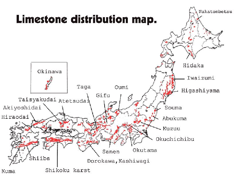
Figure 1: Distribution of limestones in Japan. Okinawa is about 400km southwest of mainland Japan.
Limestones in the Ryukyus are classified into two groups: Older Limestones (Permian, Triassic and Eocene) and Ryukyu Limestones (Quaternary). The Older Limestones are massively bedded, hard and crystalline, while the Ryukyu Limestones are poorly cemented, porous aggregates of calcareous detrital materials. The Older Limestones are used for road materials, harbour construction and cement.
Caves and karst of Okinawa
Okinawa is the largest island in the Ryukyus, with a population in excess of one million. Agriculture is the dominant land use, with extensive areas occupied by Naha city and USAF bases. There are three distinct Pleistocene terraces (Table 1) with the highest attaining 200m altitude. Water moves in discrete underground streams to coastal springs, aided by the control of faults and conjugate joints in the limestone.
Table 1: Classification of Pleistocene marine terraces in Okinawa (from Urushibara-Yoshino & Gillieson, 2001)
| Terrace | Geology | δ18O stage | Age (kaBP) |
| Low | Machinato limestone | 3-5e | 27-130 |
| Middle | Yomitan limestone | 7 | 200-230 |
| High | Naha formation: Naha limestone/Kunigami gravel beds | 9-15 | Unknown - mid Pleistocene? |
Near to the Ginowan US airforce base, Futenma-gu Cave is a Shinto shrine on the middle terrace at 70m altitude. The cave is some 280m long with three main chambers. All show some evidence of flank margin cave development (Mylroie et al, 2001). Collapse entrances have intersected mixing chambers with numerous roof cupolas and phreatic pendants. Three horizontal wall notches are well preserved and suggest former water rest levels. Thick gravelly clay deposits have been excavated to 160cm, yielding fossil deer bones. At the airbase itself, numerous caves have been mapped by NSS members posted to Okinawa. The airforce base and runways are entirely underlain by cavernous limestones with drainage to the coast. There are numerous open shafts in the limestone as well as caves such as Futenma-gu. Ongoing formation of over 130 collapse dolines, some on the runway itself, creates headaches for engineers. It is likely that drainage modification during base construction has exacerbated the problem.
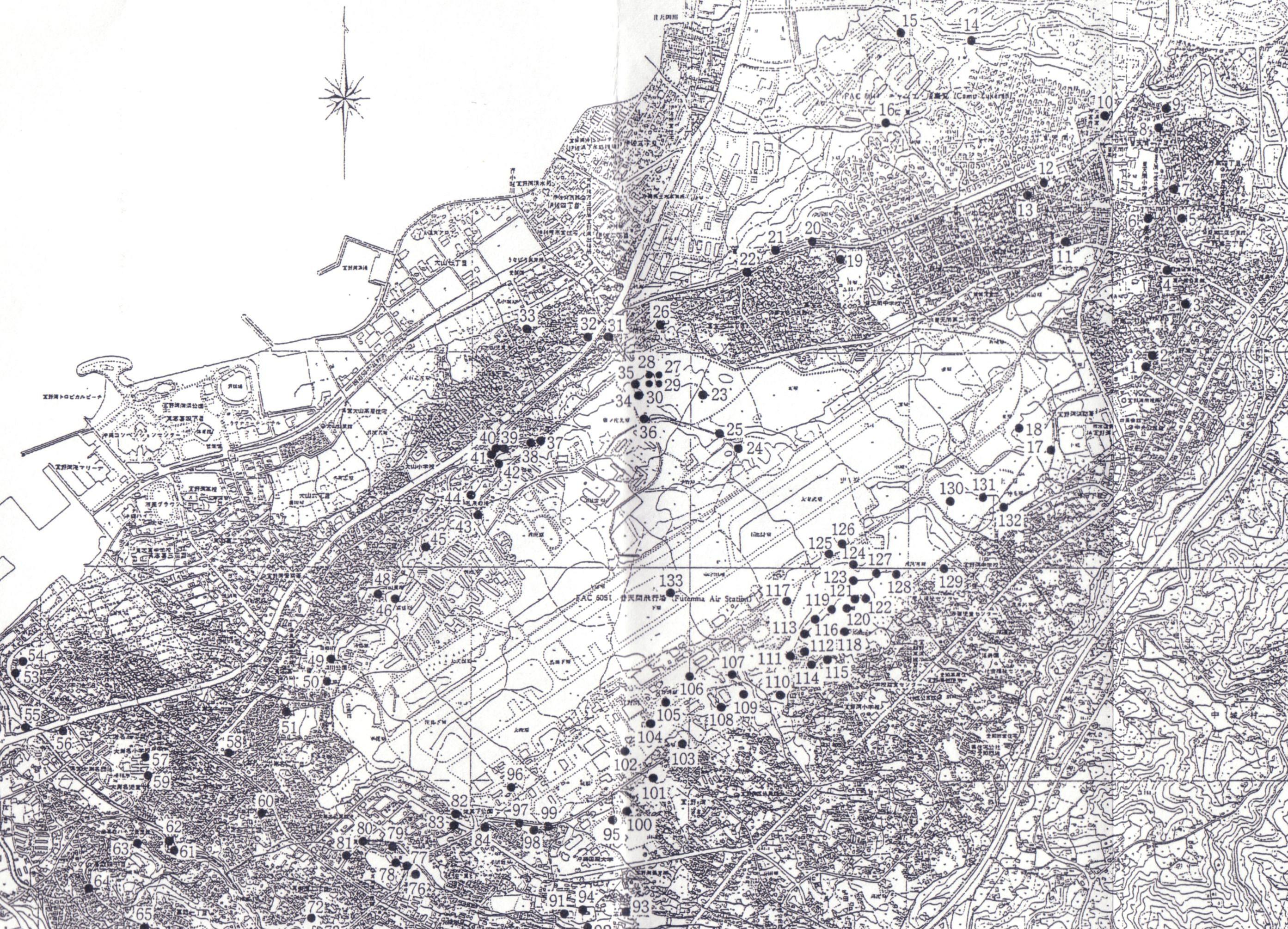
Figure 2: Over 130 collapse dolines (black dots) have formed in and around the USAF base at Ginowan on Okinawa.
In the southern part of Okinawa, the Gyokusendo cave has formed in the Ryukyu Limestone (Early Pleistocene). The cave is the source of the Yuhigawa River and shows three main levels in a large vadose canyon. The system is over 4000m long, of which 800m is open for visitors - about 500,000 annually. The cave is well decorated and lit, and interpretation covers speleothems, cave invertebrates and a bat colony. There is a strong emphasis on natural history and conservation.
Also in southern Okinawa, the Kirabaru collapse dolines and associated Oyakebaru cave are formed in Ryukyu Limestone. These features are analogous to the "banana holes" of the Bahamas, and are due to collapse into drained caves at the top of the freshwater lens. Over 30 dolines are present, with the largest being 300m wide and 10m deep. Over 4500m of cave passage has been surveyed, with an underground stream. The cave has numerous flat floored chambers with roof cupolas, connected by short joint-guided passages.
Near Ufudo, in Motobu district bare conical hills of Older Limestone resemble the mogotes of Cuba (Figure 3) and Mount Etna in Queensland; well developed karren, grikes and deep shafts cover their upper surfaces. Several well-developed poljes are floored with non-calcareous rocks and support agriculture. Contact springs on the polje margins are captured into small reservoirs and concrete channels for distribution.
At Gushikami, Holocene emerged coral reefs are well displayed, with sea cliffs and "mushroom rocks". The corals in these reefs are dated at 5500 to 6500y BP. Emerged sea caves have a minimum age of 2300y BP, with associated notches due to recent uplifting. Further south at Itoman, a wide surf bench cut in limestone is due to tsunami waves; large blocks of limestone have been lifted up to 10m vertically to rest on top of raised coral reefs. This is the most exposed coast on Okinawa.
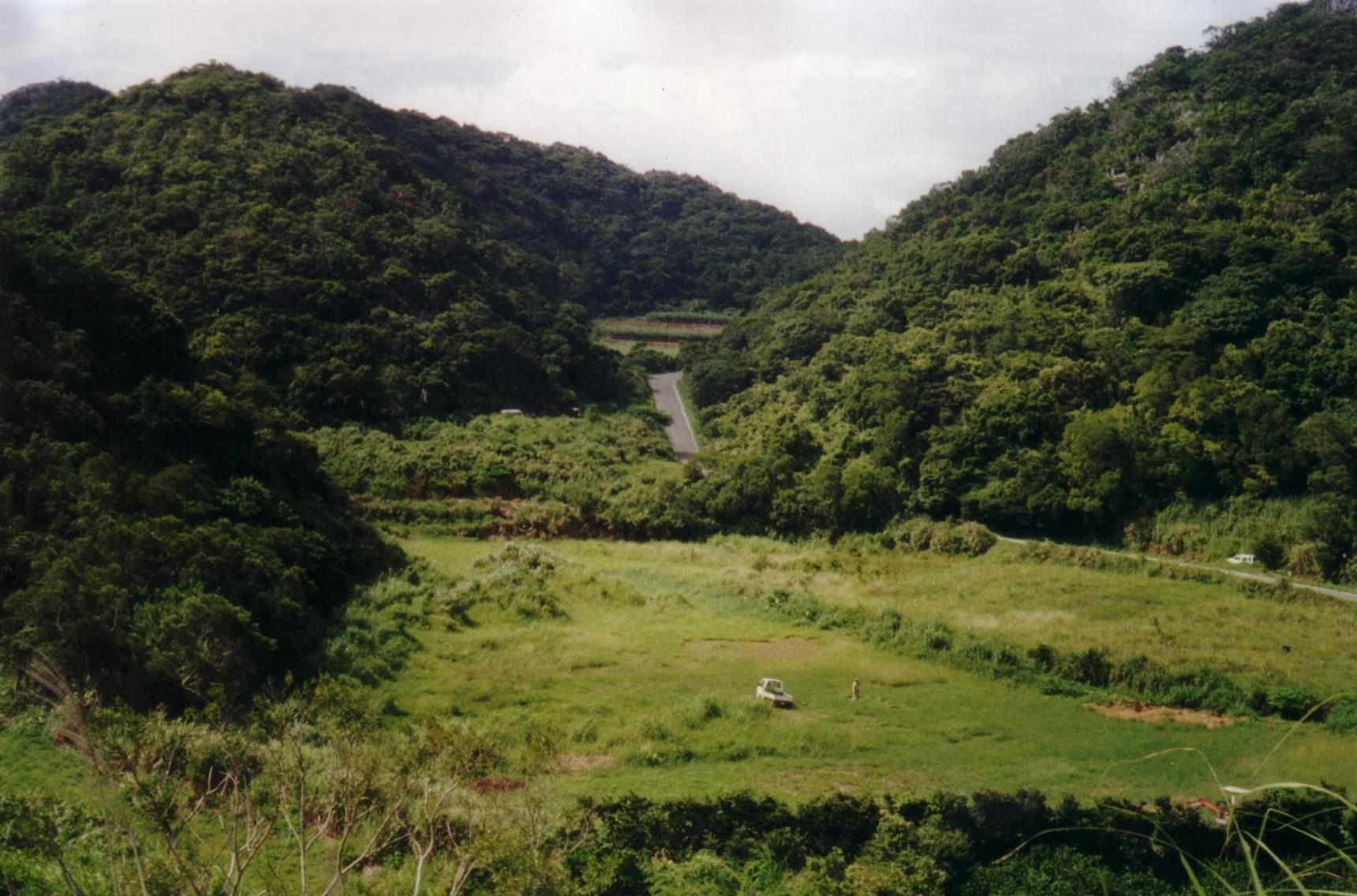
Figure 3: Polje near Ufudo, Okinawa. The conical hills are developed in Permian Motubu limestone. Springs on the polje margins are channelled into concrete drains used for irrigation.
Caves and karst of Kikai
Kikai is one of the northernmost Ryukyu islands, and is very close to the Ryukyu Trench marking the plate boundary. As a result, it has been strongly uplifted and tilted in the late Quaternary. A flight of coral terraces extends up to 224m above sea level, with a broad stepped surface on the west coast and a very steep escarpment on the east coast (Figure 4). The island is subject to earthquakes and many tsunamis. Local residents build their houses with thick walls and protected by thick stone sea walls. Lanes between houses twist and turn to reduce the swash of attacking waves.
The terraces are also deformed by step faulting, and some detachment tectonics on the underlying Tertiary siltstone is likely. Soil development reflects reef age, with red-yellow clay soils (Hapludalf) on the uppermost terrace and terra-rossa like soils (Chromic Luvisol) on the next terrace of Last Interglacial age. On the lowest terraces rendzina-like soils (Mollic Leptosol or Eutropeptic Rendoll) are present. Thus the soil sequence reflects loss of soluble carbonates over time and reduction to simple clays in a tropical weathering environment. All of the soils are relatively shallow, limiting plant growth through seasonal moisture deficit.
Over 100 springs are known on Kikai, of which eleven have a discharge over 1000m3/day and are used for irrigation. Many of these springs are located on or near faults, and water flows radially to the coast. On the northwest coast, several near-circular coves are likely to be breached springs with low cliffs modified by collapse. Hazato and Takigawa springs have enterable phreatic caves, while Nanateigama cave is a former spring located on the face between terraces C and D. It is a fissure cave with some phreatic development visible in the roof, used as a refuge by local farmers during WWII.
Holocene emerged coral reef terraces are seen on the northwestern coast at Sakamine, while tsunami-tossed coral boulders near Tonbizaki have been moved 85m from their growth position. Five earthquakes greater than Richter scale 7.4 have occurred on or near Kikai since 1901, resulting in tsunamis and loss of life.
Land management
On both Okinawa and Kikai the dominant land use is principally agriculture for sugarcane, pineapples, tree crops such as mangoes and lychees, as well as rice, melons, sweet potatoes and taro. Farms are small, typically less than 50ha, and are subsidised by central government. The crops are highly valued by urban Japanese - a wooden box of three mangoes from Kikai sells for A$30, while batik textiles produced from silk and banana fibre sell for around $30,000 for a 13m length, used exclusively in wedding kimonos.
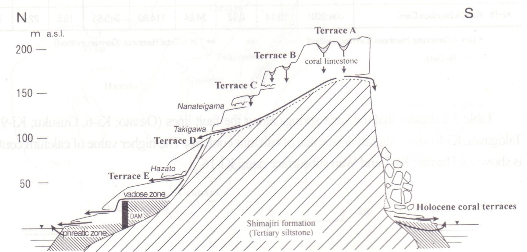
Figure 4: Cross-section of Kikai island showing caves and coral terraces. Ages of terraces are A: 115-138KA BP; B: 95-104ka BP; C: 79-83ka BP; D: 70ka BP; E:50-60ka BP. Takigawa and Hazato are large springs; Nanateigama is a fissure cave with abundant speleothems.
Cave springs and some wells in these karst landscapes provide access to drinkable water, but the combination of shallow soils and strongly seasonal rainfall produces frequent drought conditions on the Ryukyu Islands. A serious drought on these islands extends for 35-40 days. Historically these were times of severe famine and led to depopulation of some islands. Today the population is less that half of its nineteenth century size. The challenge is to develop methods for improving water retention while regulating existing water use. Soil amelioration using crushed rock, seaweed and mulch is effective and zero tillage methods show some promise. Fishing is also an important activity for the population, with high prices being paid for fish and lobsters. Tourism has started to create opportunities for local people, but infrastructure is in an early stage of development. The development of resort hotels in the Ryukyus will place heavy demands on water resources, and use of conserving technologies may be appropriate.
Recently improved water management on the porous limestones has led to an expansion of agriculture. On Kikai, a subsurface dam was built by 1999 to provide irrigation water to 1680ha of farmland. This structure (Figure 5) was created by driving a tunnel for two kilometres then drilling down and concreting to create a curtain wall. The reservoir capacity is 47,000m3 and the underground dam has locally raised the water rest level by 20m; water is reticulated across the main terrace of the island. Recently problems have arisen due to salt-water incursion in low-lying areas of the island, near to Kikai town, due to reduction in groundwater outflow by the dam.
Conclusions
The Ryukyu Islands present good examples of subtropical eogenetic karsts in a tectonically active zone, with well-displayed raised reef terraces and some fine caves. Access is relatively easy and many caves are well documented. There are a number used as Shinto shrines and these can be visited as well.
Sensible use of karst resources is well integrated into local planning, with an emphasis on resource conservation and subsidised traditional lifestyles. This is consistent with Japanese values where rural lifeways are cherished and supported by central government. Tourism has some potential, with diving and nature based tourism (including cave tours) being the obvious sectors to develop. The challenge will be to permit this development while conserving water resources and the local culture.
Acknowledgements
During August 2001 I was the recipient of a Fellowship to Japan under the auspices of the Japan - Australia Exchange Scheme run by the Australian Academy of Science and the Japan Society for the Promotion of Science (JSPS). Professor Kazuko Urushibara - Yoshino of Hosei University, Tokyo and Professor Akira Maekado of the University of the Ryukyus, hosted my visit to the Ryukyu Islands of southern Japan. I advised land and water managers on Okinawa and Kikai islands about sustainable use of limestone soils and associated water management. Mr. M. Nakachi, the Head of Gyokusendo Cave and staff of the Ryukyu Cement Co. Ltd facilitated our work on Okinawa. On Kikai, I am grateful to Mr. K.Kato, the Mayor of Kikai Town Office, and Mr. M. Honda, the Chief of Construction of the Kikai Island Subsurface Dam National Irrigation Project Office.
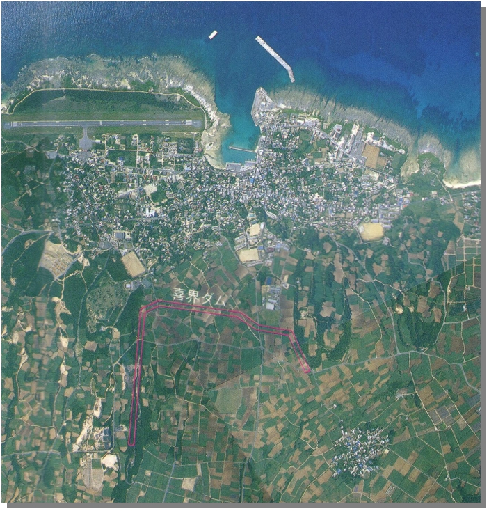
Figure 5: Aerial photograph of coral terraces and underground dam (linework) on the north coast of Kikai, Ryukyu Islands, Japan.
Bibliography
Ikeda, S., Kasuya, M. & Ikeya, M. 1991. ESR ages of middle Pleistocene corals from the Ryukyu Islands, Quaternary Research 36:61-71
Mylroie, J. E., Jenson, J.W., Taborosi, D., Jocson, J.M.U., Vann, D.T. & Wexel, C. 2001. Karst features of Guam in terms of a general model of carbonate island karst, Journal of Cave and Karst Studies 63(1):9-22
Ota, Y. & Omura, A. 1992. Contrasting styles and rates of tectonic uplift of coral reef terraces on the Ryukyu and Daito Islands, southwestern Japan, Quaternary International 15:17-29
Urushibara-Yoshino, K. & Gillieson, D. 2001. Human Activities and Sustainable Development in Karst Areas, Joint Scientific Seminar under the Japan-Australia Research Cooperative Program, Hosei University, Tokyo, 90pp