STATE OF PLAY — CONSERVATION STATUS OF THE MOLE CREEK KARST AND ITS CATCHMENT
Abstract
The Mole Creek Karst and its catchment occupy a synclinal basin between the Gog Range to the north and the Great Western Tiers to the south. The majority of the area is private freehold in tenure, including much of the catchment. The rest is largely State Forest and some State Reserve and Crown Land. Many of our famous caves are outside the Reserve system.
Local conservation campaigns focussing on the Great Western Tiers began over 20 years ago, and have included karst issues since 1983. A proposal exists for a National Park for the Great Western Tiers, karst and karst catchment comprising some 30% of the Proposal area. Most of the area is listed on the Register of the National Estate and some is World Heritage Area (WHA). Future forestry and mining pose threats. Planning is piecemeal in nature.
An overview of campaigns, the Park Proposal and industry planning and connotations is presented.
INTRODUCTION
Due to local climatic conditions, a legacy of glacial activity, the high "purity" CaCO3 content of the Ordovician limestone and thick forest cover in the catchments and above the caves a densely cavernous karst has developed at Mole Creek, which hosts active speleothems of wide repute. An abundance of cave fauna exists, many forms of which await scientific description, and few are protected species. The integrity of the karst is still good overall. The karst exhibits all stages of development from youthful to senile. The area of exposed limestone extends approximately 26km east/west by 10km north/south, and contains nearly 300 documented caves. Mole Creek has a history of cave tourism dating from white settlement.
Much of the valley was already grassy at the time of white settlement, George Augustus Robinson commenting on the rich luxuriant pastures (of the Pallattorre people). Much development has occured since then, selective (and now clearfall) logging, farming and grazing, further land clearance, mining for agricultural and industrial lime and show cave development included. The greatest present day threat in terms of land use to karst values is modern tree harvesting within the State Forest of the area. To date, 150 years of logging in the old style has left the biodiversity of the State Forests of the Great Western Tiers largely intact, and there still exists some pristine areas.
CONSERVATION BACKGROUND
A detailed examination of the development of the conservation campaign can be found in Illuminations 1, but for now I'll be brief. Local campaigns began in 1972 in the face of escalating and increasingly mechanised logging efforts. I'll emphasise that then, as now, campaigns for the Tiers were carried out by local residents. As a local with speleological interests, I became involved as the campaigners gave recognition to the fact that the Tiers are a geographical unit which includes karst and karst catchment.
The now Western Tiers Campaign developed a proposal for a Great Western Tiers National Park, released in January 1990 and endorsed by all major Tasmanian conservation groups, as a response to the piecemeal and unsatisfactory approach to management of particularly the (then) Forestry Commission, now the Forestry Tasmania Corporation. The ASF showed its support by resolution at the 1993 Council meeting. Recommended reading includes Bob Burton's article on Resource Security legislation (RSL). It had also become clear that the local limeworks had its sights on the Dogs Head hum, as demand for industrial lime, particularly associated with the future increased production of paper pulp from eucalypt feedstock, looked likely to deplete existing reserves twice as fast. One of the outliers of the Proposal is the Dogs Head. The Proposal area contains no private land.
In 1983, an area of 8,850 ha, "The Mole Creek Caves", was placed on the National Estate Register, along with the slopes of the Tiers above 800m (there's few loggable trees there apart from a few topographic benches). Since the declaration of temporary boundaries of the Western Tasmania Wilderness World Heritage Area post the Helsham enquiry, the Tiers have been shown to be of World Heritage value by a Parks report, yet those boundaries remain unchanged. The biological values have also been well-documented. World Heritage status was afforded the existing State and Forest Reserves, however this was a political decision only, and the whole of the Tiers should have been included in the actual listing even if only as a buffer zone, according to WHA guidelines.
Kevin Kiernan commenced his (Forestry Commission sponsored) reconnaissance inventory of the karst and land use in 1983 and made Reserve proposals which have yet to be implemented. The Recommended Areas for Protection (RAPs) are still just that - recommended. Even so, the Dogs Head is recommended as a representative example of a dry sclerophyl forest, not as Australia's only true example of a hum, containing the rare, perhaps unique, phototropic phytospeleothems. Mining is still allowable in RAPs; it's only logging which is prohibited. All other threatening land uses still can occur. Most of the karst and karst catchment under Forestry Tasmania's control is classified "conditional" under "deferred" forest status but is counted in Forestry's total resource assessment, which is assumed available in the juggling act of resource allocation for companies licensed to export woodchips. The protection of conditional deferred forests depends on industry efficiency improvements for which there is no incentive.
The Park Proposal is currently under review for a second edition. Proposed boundary changes include the "windgap" and (southern) catchment of the Dogs Head (consistent with Kiernan's recognition of it) and a further outlier, Wet Cave Reserve. Input is welcomed, and a discussion document "Towards a Great Western Tiers National Park Management Plan" is open to comment. The Park proposal has now been on the National conservation agenda for some time.
LAND USE, TENURES AND CONSERVATION
It is difficult, to make an understatement, coming to grips with nature conservation in a karst area with such a patchwork of tenures as Mole Creek. About half of the forested slopes of the Great Western Tiers seen from the valley floor are privately owned. The majority of the remainder is State Forest and the rest State and Forest Reserves. These slopes contain streamsinks and caves. The valley floor is mostly private freehold, and the ridges and hillocks are a mixture of tenures.
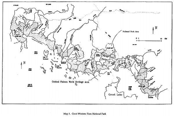
Map 1
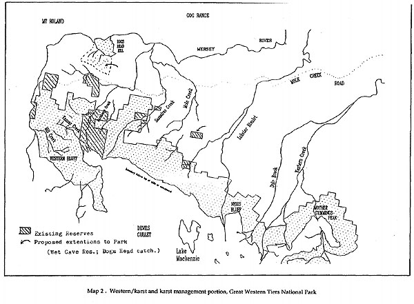
Map 2
There are many major caves outside Reserves and there are many whose entrances lie within Reserves but which extend beyond. Those outside Reserves include Flowers Pot, Prohibition, My, Their, Tailender, Rat Hole, Rubbish Heap, Execution Pot, Herberts Pot, Scotts, Westmorland, Pyramid, Black Shawl, Shishkebab, White Rabbit, Mersey Hill, Union, Moss Palace and Big "L" Pot. Major caves which extend beyond Reserves include Croesus, Lynds, Wet and Sassafras. Logging and other activities upstream and above caves have been shown elsewhere to have effects on the karst resources. Detrimental practices relating to agriculture include dumping in surface karst features, stock access to karst streams, dairy effluent disposal, diversion of inflows, cropping around dolines, within uvulas or on slopes and the threat of a large proposed piggery* in the immediate catchment of the Mole Creek system itself. Infections of leptospirosis (also known as "Weil's disease") has been associated with exposure to piggery run-off while caving.
The ideal situation at Mole Creek would be the declaration of the National Park as proposed, allocation of the remaining State Forest for the sustainable use of the local community and the carrying out of sustainable practices by an educated private landowner sector. Some existing practices could probably continue in a limited area covered by an "underground National Park". As an election promise, Harry Holgate, Premier and leader of the outgoing Tasmanian Labor Government in 1992, mooted "underground National Park" type protection for caves in Tasmania, and consideration is being given to supporting the concept in the revised Park proposal, particularly for the Mole Creek system above Wet Cave Reserve.
Of topical interest, the Mount Cripps karst, which has only one tenure (State Forest) and extremely limited access, was this summer half burnt out by an arsonist who probably boated across to start the fire on the lakeside. (M. Lichon, pers. comm., 1995)
A karst is a landscape unit, and its catchment integral to its ecological and other processes. However, the managers of the various tenures of the Mole Creek karst are not coordinated towards its sustainable use.
CONCLUSIONS
- A new philosophical approach is needed in weighing up whether or
not to approve a development in a karst landscape. There are competing
interests for the same resource to consider, all of which have their own
potential impacts.
In developing Wild Cave Tours, I came up with a concept which could be widely applied- Net Benefit (environmental emphasis) (Fig. 1). This line of thought was further conceptualised at the recent "Women and the Environment" Conference (Fig. 2) when it was expressed that there was a need for a new philosophical approach in managing wild places. A subtle shift resulting in what can be best described as "ecology of mind". At the same Conference, "wilderness" was discussed, and this has direct bearing on karst management/conservation philosophy. "Wilderness" is a racist concept, and is only 200 years old. Until then, Australian "country" (term prefered by Aboriginal women) included its native inhabitants. Rather, "wilderness" is really an applied human value, resulting from a person's interaction with a natural setting (Fig. 3). It is OK that "wilderness" means different things to different people: it always will. Let us manage the karst resources to enable quality nature experiences, both remote and close at hand.
- Support is needed for the proposed National Park from all local community sectors and interested bodies and persons. Resources of conservation importance to non-speleologist locals within the karst and its catchment include water, soil, biodiversity, timber, scenery, quality recreational opportunities and the spectacular active speleothems which return tourist dollars to the community economy. The local municipal body, the Meander Valley Council, could have great influence on the declaration of the Park and the education of the community into better living with limestone.
* The piggery proposal was disallowed by the Meander Valley Council in 1995
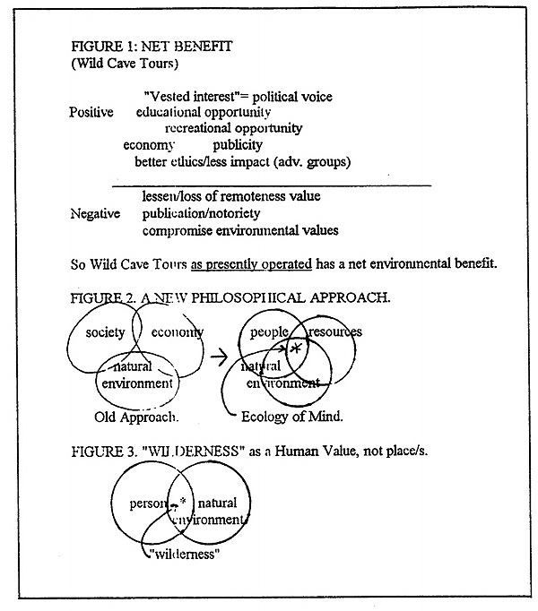
Figure 1,2 & 3
REFERENCES
Burton, R. (1994). Resource Security Legislation. (in) Illuminations 3, Journal of the Mole Creek Caving Club.
Cadman, S. et el (1990). The Great Western Tiers: The Case for Conservation. A Proposal for a Great Western Tiers National Park. Deloraine Environment Centre Inc.
Department of Parks, Wildlife and Heritage (1990). Appropriate Boundaries of a World Heritage Area in Western Tasmania.
Hunter, D. (1992) A Brief History of Cave Conservation at Mole Creek and the Development of the Great Western Tiers National Park Proposal. (in) Illuminations 1, Journal of the Mole Creek Caving Club.
Kiernan, K. (1984). Land Use in Karst Areas- Forestry Operations and the Mole Creek Caves. Report to the Forestry Commission and the National Parks and Wildlife Service Tasmania.
Kiernan, K.,Eberhard, R. and Shannon, C.H.C. (1994). Further Hydrogeological Investigations of the Mill Creek- Kansas Creek Area, Northern Tasmania. (in) Tasforests (Vol. 6), Forestry Tasmania.
Kirkpatrick, J.B. and Moscal, A. (1986). Conservation Status of the Vegetation and Flora of the Great Western Tiers Tasmania. Report to the Australian Heritage Commission.
Lichon, M. (1992) The Phototropic Phytospeleothems of Moss Palace, Mole Creek, Tasmania. (in) Helictite 30 (1).
Lichon, M. (1992) The Right to Farm- the Latest Threat to the Mole Creek Karst.(in) Illuminations 1, journal of the Mole Creek Caving Club.
Lichon, M. (1993) Response to the Forestry Commission Draft Management Plan for the Great Western Tiers. (in) Illuminations 2, Journal of the Mole Creek Caving Club.
Western Tiers Campaign (1993). Towards a Great Western Tiers National Park Management Plan. Deloraine Environment Centre Inc.