RESERVATIONS ABOUT TASMANIAN KARST
INTRODUCTION
In assessing land management options for karst environments, we should first consider why such areas need protection. Kiernan (1988, 1989) discussed issues relating to karst systems, their protection requirements and land management in detail. A summary is provided here:
Karst may be significant for a variety of reasons which can generally be grouped into:
- nature conservation
- recreation
- aesthetic considerations
- archaeological and historical associations
- folklore or religious considerations
Nature conservation in karst areas, including scientific values, covers such fields as geology, surface and underground geomorphology, hydrology, climatology, vertebrate palaeontology and surface and underground biology. Recreation in karst areas ranges from conventional commercial tourism through to 'adventure' tourism and outdoor recreation (e.g. school, scout groups, individuals) - both inside and outside caves. Aesthetic considerations, especially the 'attractive qualities' of speleothems and glow worms etc. are a major factor in the recreational use of caves by tourists and adventurous others. Caves are archaeologically important on an international scale, including several Tasmanian caves. Historically, caves have been used, world wide, by rebel armies, bushrangers and other fugitives. Many Asian caves house shrines and temples, whilst many Australian caves have significance for its indigenous people.
Kiernan (1989) also discussed the effects of not adequately protecting karst areas. The contamination of karstic water supplies, particularly through rural land use and sewage, has led to serious health problems downstream such as typhoid, gastroenteritis etc in some overseas areas (Mosely 1959, Waltham 1978). Other problems, more confined to the conservation values of karst include wanton vandalism and accidental breakages of speleothems and disturbance of biota. Excessive use of some areas may also damage caves. In some areas, degraded caves may attract fewer visitors thus reducing recreational and tourism potential.
Given the need for protection of karst areas, the most feasible options available in the Tasmanian context are:
- reservation under an Act administered by the Parks and Wildlife Service or Forestry Tasmania;
- protection through local government planning schemes;
- ad hoc protection through off-reserve (usually private land) conservation schemes such as Landcare and conservation covenants; and
- protection indirectly flowing from other legislation such as the Conveyancing and Law of Property Act 1884 (amended by the Private Forests Act 1994) and the now defunct Land Conservation Legislation.
This paper reviews processes available to protect karst (or other conservation values) administered by the National Parks and Wildlife Service, Tasmania. A thorough examination of other available options administered by other agencies is outside the scope of this paper. However, related issues dealt with by Forestry Tasmania have been discussed elsewhere in this volume (Whitely, this volume).
RESERVATION
Often it has been argued that reservation, or other formal and less formal protection measures for land, are unnecessary in areas where there are no demonstrated threats to the values. Karst at Mt Cripps, in the north west of Tasmania, is currently deferred forest and under concession to North Forest Products, Burnie. Management has been sympathetic to the conservation of the karst values and has worked together with the local Savage River Caving Club in effectively managing the area. However recently the manager moved elsewhere and there is now no guarantee that the incoming manager will operate the area in the same sympathetic manner as before.
The most effective protection for any area is attained when there is a consistent and on-going competent management regime. Legislative reservation is one of the best ways to achieve such protection, as it affords the long term security of tenure to enable a management regime that many other options cannot guarantee. A major advantage of legislative reservation of significant karst areas includes a greater potential for effective on-going management through the development of statutory management plans. For example, these can include areas adjacent to, or upstream of, the karst which may affect its underground hydrology. Reservation under the National Parks and Wildlife Act 1970 provides greater scope for adequate funding for management in the region than alternative forms of protection, particularly those with no legislative background which often attract only 'once-off' funding through Commonwealth grants. However, reservation of Forestry Tasmania managed areas may be even more likely to attract sufficient resources, given the partially self-funding base of that organisation. Legislative reservation also affords a greater protection of the areas from other statutory powers such as mining exploration.
Legislative reservation also brings with it the bureaucratic baggage of increased management responsibilities that are often not sufficiently matched by funding increases in reality, although theoretically, funding is more likely in such circumstances. Reservation of an area automatically raises its public profile, thereby attracting more visitors which increases pressures on managers to provide facilities and services. Increased visitation, particularly in karst areas, can also lead to degradation of those features that initially attracted the visitors. In reality, land tenure and catchment boundaries do not coincide, therefore reserves do not usually encompass entire catchments. As the surface catchments do not necessarily reflect the underground catchments in karst regions, reservation based on practical surface considerations is even less likely to adequately protect the karst than other conservation values. Suitable areas for reservation are often determined by current freehold boundaries, and given the present state of funding for land acquisition, it is unlikely that there will be any opportunity to purchase such land for incorporation into reserves. However, options other than land purchase, that are available to enable reservation of some areas are discussed later in this paper.
What has been reserved?
To date, no areas have been reserved specifically to protect surface karst features*. Historical reservation of karst areas has mainly been associated with tourist caves (or caves thought at the time to have tourist potential), such as at Mole Creek, where there is a variety of different land tenures from State forest, State reserves, Crown land reserves and unallocated Crown land. 'Wild caves' that have been reserved include Exit Cave, Croesus Cave and Kubla Khan Cave. Some reservation of karst areas has been 'accidental' where those areas have been included as part of a larger reservation, such as at Precipitous Bluff in the World Heritage Area. The ad hoc reservation of karst areas is set out in Table 1.**
Table 1: Summary of reserved karst areas in Tasmania administered by the National Parks and Wildlife Service. NPW Act = National Parks and Wildlife Act 1970; CL Act = Crown Lands Act (date given); SP Act = Scenery Preservation Act 1915; WHA = World Heritage Area; SR = State Reserve [# = Source: Harris and Kiernan (1971)]
| Karst area | Type of reserve & Act | Effective date | Notes |
| Trowutta Caves Reserve | State reserve, NPW Act | 11/10/76 | Noted on original charts as a caves reserve in 1920s, but only formally reserved when a neighbour began illegally using the area in the 1970s. |
| Baldocks Cave Reserve | State reserve, NPW Act | 16/8/39 | Originally proclaimed under SP Act and automatically became SR in 1971 (after advent of NPW Act). Is part of the proposed Mole Creek Karst National Park. |
| Junee Cave | State reserve, NPW Act | 8/9/76 | Proclaimed for its geomorphological values. |
| Kubla Khan | State reserve, NPW Act | 8/9/82 | Is part of the proposed Mole Creek Karst National Park. |
| Croesus Cave Reserve | State reserve, NPW Act | 12/7/72 | Is part of the proposed Mole Creek Karst National Park. |
| Marakoopa Cave | State reserve, NPW Act | 16/8/39 | Originally proclaimed under SP Act and automatically became SR in 1971 (after advent of NPW Act). Is part of the proposed Mole Creek Karst National Park. |
| King Solomon Cave | State reserve, NPW Act | 16/8/39 | Originally proclaimed under SP Act and automatically became SR in 1971 (after advent of NPW Act). Is part of the proposed Mole Creek Karst National Park. |
| Exit Cave | State reserve, NPW Act | 4/4/79 | Previously Exit Cave SR, now incorporated into Southwest National Park (27/6/90) and part of the WHA |
| Hastings Cave Reserve | State reserve, NPW Act | 12/6/19 | Includes entrances of Newdegate Cave (tourist cave) and King George V Cave. Needs boundary adjustment to include all of the important caves.# |
| Ida Bay (Mystery Creek Cave) | State reserve, NPW Act | 23/12/81 | Reserve originally protected entrance to Mystery Ck Cave. All of Mystery Ck Cave is now in the Southwest National Park and is included in the World Heritage Area. |
| Gunns Plains Cave Reserve | State reserve, NPW Act | 19/2/81 | Originally proclaimed under SP Act and automatically became SR in 1971 (after advent of NPW Act). Reserve includes tourist cave entrance, but not the majority of the cave. |
| Wet Cave and Honeycomb Cave | Crown land reserve,CL Act 1890 | 6/11/1894 | Is part of the proposed Mole Creek Karst National Park. |
| Westmorland Falls Reserve | Crown land reserve, CL Act 1903 | 27/2/09 | Is part of the proposed Mole Creek Karst National Park. |
| Eugenana | State reserve, NPW Act | 19/10/77 | A small reserve (0.87 ha) to protect Eugenana Beds terrestrial cavern fill. The only known cave in the area, Sherrils Cave, is outside the reserve.# |
| Sensation Gorge | State forest, Forestry Act 1920 | not formally declared | Noted as a reserve on original charts as a scenery reserve, but not formally proclaimed. Is to become part of the proposed Mole Creek Karst National Park. |
A proposal for a Mole Creek National Park was first mooted in the mid 1980s by Kiernan (1989), and proclamation of the current reserve proposal is now gathering momentum, although in a far less encompassing form. The present reserve proposal for the Mole Creek Karst National Park was supported by the incumbent Tasmanian government in early 1996 and is largely comprised of reserves already under the National Parks and Wildlife Act 1970 (Figure 1). Whilst its non-controversial nature has ensured an easy passage through Parliament, it is hoped that additions to the park may be secured in the future in order to provide more geographically-logical boundaries.
The current proposal includes the following areas: the Mole Creek tourist caves (King Solomon Cave State Reserve and Marakoopa Cave State Reserve), three State reserves (Croesus Cave Reserve, Kubla Khan Cave State Reserve and Baldocks Cave Reserve), two Crown land reserves (Wet Cave Reserve and Westmorland Falls Reserve) one area within State forest (Sensation Gorge) and an unallocated block of Crown land with an interesting karst feature.
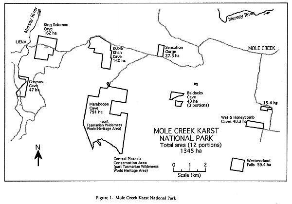
Figure 1 Mole Creek Karst National Park
What should be reserved?
A rule-of-thumb in selecting areas for reservation for any conservation values should be the significance of the values based on their unique, outstanding and/or representative qualities. Ideally, in the short-term, those unique or outstanding areas that are either unreserved or poorly reserved* should be immediately reserved. Table 2 outlines a preliminary list of such areas within Tasmania.
Table 2: Unreserved or poorly reserved Tasmanian karst areas. NP = national park; SR = State reserve; FR = Forest Reserve; SF = State forest; UCL = unallocated Crown land; PL = private land; NPW ACT = National Parks and Wildlife Act 1970; P&WS = Parks and Wildlife Service
| Area | Current land tenure | Values | Proposed reserve type |
| Junee-Florentine | NP, SF, SR | highly significant integrated karst system | Addition to Mt Field National Park |
| Hastings Cave reserve | SR, SF | major tourist cave administered by P&WS | Addition to Southwest National Park, or more preferably the WHA, allow consistent management |
| Tarkine magnesite | SF, UCL | unique feature to Tasmania | SR under NPW Act |
| Mt Cripps | SF | polygonal karst in excellent condition | SR under NPW Act |
| My Cave & Tailender system, Mole Creek | SF | part of the highly significant integrated karst system at Mole Creek | Addition to proposed Mole Creek Karst National Park or at least a permit system should be developed under the present tenure |
| Elephant Pass, Gray | PL | karst in Permian limestone | SR under NPW Act or FR under Forestry Act 1920 |
| Kiernan's (1984) identified sites at Mole Creek | PL | highly significant integrated karst system | Addition to proposed Mole Creek Karst National Park. |
| Croesus Cave | SF | proposed to contain whole of Croesus Cave catchment within reserve | Addition to proposed Mole Creek Karst National Park |
The assessent of 'representativeness' of karst areas is still in its infancy. Kiernan (1995a, b) has recently produced an Atlas of Tasmanian Karst, based on representativeness of karst areas. However, this needs to be further addressed, as many decision-makers rely on 'objective' classification systems to help justify their choices. In the interim, however, uniqueness/outstandingness and representativeness of areas must be assessed concurrently to ensure that no important sites are overlooked in any reservation decisions.
TYPES OF RESERVATION
The Parks and Wildlife Service administers the Crown Lands Act 1976 and the National Parks and Wildlife Act 1970, under which it is most likely that karst areas will be reserved. Karst areas may also be reserved under the Forestry Act 1920 administered by Forestry Tasmania, although the discussion of this Act and such reservation is outside the scope of this paper. The Tasmanian Public Land Use Commission has recommended a revised classification system for Tasmania's reserves, that can be allocated within the IUCN Protected Area Categories System and incorporates the present Tasmanian reserve system (PLUC 1995).
The Crown Lands Act 1976 does not prescribe specific reserve titles, but rather assigns them on the basis of the reserve's primary function. Present karst areas reserved under this Act includes Wet Cave Reserve, which was declared for the protection of the caves. Reserves under the Crown Lands Act may be declared or revoked by Ministerial order, and as such, are less secure than those under the National Parks and Wildlife Act 1970 that require the approval of both Houses of Parliament for their proclamation or revocation. Similarly, land reserved under the Crown Lands Act 1976 is subject to a wider range of uses, and is therefore less protected, than reserves under the National Parks and Wildlife Act 1970. Forest reserves are dedicated by the Governor under the Forestry Act 1920, but need the approval of both Houses of Parliament for their revocation. However, they are not subject to the National Parks and Wildlife Regulations 1971 and are open to a wider range of uses than reserves under the National Parks and Wildlife Act 1970. Therefore, the actual protection of conservation values within such reserves may be less secure than in reserves under the latter Act.
Section 13 of the National Parks and Wildlife Act 1970 makes provision for areas to be set aside for a variety of 'conservation purposes'. Conservation area regulations (as prescribed by the National Parks and Reserves Regulations 1971) apply to all reserves under this Act. Additional specific regulations apply to State reserves, giving them further protection. Table 3 shows the reserve types under this Act that are applicable to the reservation of karst areas.
Table 3: Overview of reserve categories applicable to karst areas under the National Parks and Wildlife Act 1970. (Source: Parks and Wildlife Service 1994)
| Major conservation category | Designated or prescribed reserve title | Land type that can be reserved |
| State reserve | National Park State Reserve Nature Reserve Aboriginal Site |
Crown land |
| Conservation area | Conservation Area Wildlife Sanctuary |
Any land |
OTHER RESERVATION OPTIONS
Mention has been made of the many areas set aside as reserves which do not follow the best geographical boundaries; their size and shape being influenced by such restrictions as other land tenures, funding and political willpower. In some instances, the present reserves clearly are not fulfilling their protective role for the conservation values of the area. Gunns Plains State Reserve is a case in point, whereby the reserve boundaries form a north-south rectangle over the cave which lies in an east-west direction, predominantly through private land (with a 'centre of the earth' title). Apart from the problems associated with the Crown apparently leasing land not under its ownership or control to a concessionaire, there is currently little or no protection for that part of the cave subject to the private landholder's agricultural practices above. The best option to rectify this situation is to acquire the private land title above the cave. This is presently being pursued through a land exchange proposal with the owner of the land.
The alternative option of compulsorily acquiring the land in question is usually considered a 'last resort'. Although the Government may identify the land and acquire it under the National Parks and Wildlife Act 1970, compensation must be paid to the landowner equal to a fair and reasonable market value of the land. Therefore, this measure is not lightly undertaken, given both the limited funds for land purchase and general ill-feeling such moves create within local communities.
In other instances, because of the difficulties associated with acquiring land in karst areas to protect underground features it has been proposed that only the 'cave' is reserved, leaving a private land tenure on the surface. Whilst this option may seem to be an acceptable compromise to the landholder and the cave manager, difficulties are associated with the boundaries of the cave. Are they a set distance from the edge of the 'hole' underground? Does the reserve include only the 'hole'? Does the reserve boundary allow for presently undiscovered parts of the cave being subsequently discovered and mapped? Does the reserve boundary include all those tiny karstic passages that cannot be mapped, or even identified?
Aside from the boundary definition problems, the issues of the landholder directly affecting the underground reserve should be considered. Currently, many reserved karst areas are downstream of private agricultural land, which is undoubtedly affecting the karst. However, some agricultural practices on land directly over a karst environment are far more likely to directly affect the karst, where the effects cannot be diluted or spread over a wider area. Therefore it would be paramount for managers of reserves created under private land to liaise closely with landholders above in order to protect the karst reserve. If this effectively results in substantial landuse changes for the landholder, then the objective of dual landuse through a section of the earth has been defeated and probably the karst would be better protected through conventional reservation of the surface, including the cave.
Similar landuse problems could be encountered with the proposal to reserve the cave from a set depth below the surface. Although the majority of Tasmanian titles are to a 15 m depth below the surface, older titles granted before 1911 are generally to the centre of the earth* . Therefore, acquisition (and compensation) would be necessary in those cases - with the landholder getting a 'windfall' for land that he/she probably would not have used in any case! As with the option of reserving the 'cave' only, problems would arise where conduits to the main part of the system lay within 15m (or the defined depth) of the surface. Cave entrances, by definition, would pose particular problems, being within the 15m of the surface. Once again, not all the system could be effectively protected, unless the adjacent private land was managed sympathetically.
Another alternative to land purchase is to lease land from the landholder, proclaim and manage it as a reserve under the National Parks and Wildlife Act 1970. The land is in all respects as secure as a reserve proclaimed under the Act on Crown land, except that reservation is only as secure as the lease. Change of ownership of the land may well bring pressure on the land manager to alter or cancel the lease, or the landowner may not renew the lease on its expiry.
OPTIONS TO MANAGE LAND OUTSIDE RESERVES
Several options area available to manage land outside reserves - each with varying legislative clout and subsequent success.
Planning schemes
There is scope within local government planning schemes to provide for reservation of areas. As the adoption of a planning scheme results in a statutory document, the area will be probably be satisfactorily protected, provided that specific prescriptions appear within the document to adequately identify and manage the karst (or other conservation) issues. Security of tenure, so necessary for the long-term viability of an area, is not generally available through planning schemes, that are reviewed, with the possibility of changes, at fairly short intervals. In recent years the Meander Valley Council has recognised that a significant part of that municipality lies within the Mole Creek karst region, and is preparing to specifically address the issue in its planning scheme.
There appears to be little consistency across different planning schemes to date, and therefore a consistent overall State-wide approach to the management of conservation values is unlikely to eventuate in the near future. However, planning schemes must refer to State policies developed for specific issues such as water quality and catchment management. Therefore, the integration of karst management, and geoconservation generally, into the relevant policies is paramount in ensuring karst issues are addressed more systematically in planning schemes.
In addition, some planning schemes are adopting a less prescriptive approach than in the past. This leaves the path open for more subjective land management decisions which may well be based more on the persuasive powers of those who would develop, rather than those who would conserve, the land. In practice, such planning schemes may be more prone to short-term whims replacing long-term strategies.
Private conservation areas and covenants
Private land may be voluntarily declared a 'private conservation area' under the National Parks and Wildlife Act 1970. This brings the land under both that Act and the National Parks and Reserves Regulations 1971 for any public use of the area, and allows the Parks and Wildlife Service to intervene in any unauthorised public use of the land. However, the landholder may manage the land in any way, and is not restricted in his or her use of the land. The conservation area status travels with the title of the land and may only be revoked by the Minister, at the request of the landholder or the Parks and Wildlife Service. Whilst earlier conservation areas were not recorded on the title to the land, new areas declared after 1995 will be registered, in order to alert future owners to status of their land.* In practice, landholders who request such protection of their land tend to manage the land in accordance with its conservation values. Landowners may enter into management agreements with the Parks and Wildlife Service and call upon the advice of its rangers and specialist staff in the management of their land.
Covenants on private land titles, when combined with a 'private conservation area' status provide further protection for the area. Covenants can be arranged under either the Conveyancing and Law of Property Act 1884 (amended by the Private Forests Act 1994), or under the National Parks and Wildlife Act 1970 which allows for greater flexibility in developing covenants. If the land is subject to covenants and conservation area status, then the public are restricted under the National Parks and Wildlife Act 1970 and the landholder must manage the land according to the specific covenants. As both covenants and conservation area status travel with the title, the land is as secure as the strength of covenants, and the wills of the landholder and government agreeing to retain both forms of protection.
Problems with private conservation areas and covenants may occur with the non-compliance of them and the subsequent lack of recognition on the part of the overseeing authority. Once more, inadequate funding for monitoring and management of private areas may result in their degradation to the point where their conservation area status no longer applies and requests are made for the area to be revoked. Neither covenants or private conservation areas are as secure as formal reservation in that the former can be varied or removed from the title with the agreement between the landholder and the Minister and the latter declared or revoked by the Minister. Formal reserves, as described previously, require the approval of both Houses of Parliament for the proclamation or revocation.
Incentives for landholders
The Land Conservation Legislation that was drafted, but did not proceed, in 1992 proposed to offer incentives to landholders for conservation of their land. Today, Landcare schemes such as Save the Bush and One Billion Trees now offer financial assistance for landholders to conserve or rehabilitate their land. However, these schemes are somewhat ad hoc, are very much dependent on Federal funding from year to year and can tend to be more directly aimed towards land rehabilitation in terms of agricultural management rather than primarily for nature conservation. Nevertheless, with enough foresight, it is probable that karst areas could be directly safeguarded under one of these schemes by protecting (and rehabilitating if necessary) the vegetation and inflow streams in the immediate vicinity of the karst.
Other strategies
Codes of practice, such as the Forest Practices Code 1985, have been developed to regulate specific activities in specific areas. Karst is addressed in the Forest Practices Code 1985 in order to help protect those areas on Forestry Tasmania managed land. These codes are voluntarily developed by managing authorities and, whilst not having inherent legislative powers, fall under a relevant Act which necessitates compliance with the code.
Eberhard (1995) described how a Karst Management Zonation Scheme, designed to aid management of karst on Forestry Tasmania administered land, has been used in the Junee River catchment. The scheme incorporates recommendations within zones classified on the basis of their 'sensitivity' from a karst conservation perspective and refers to the Forest Practices Code 1985 in its recommendations. The scheme refers to Forestry Tasmania's Management Decision Classification (MDC), which differentiates State forest on the basis of its availability for wood production and recommends a proposed MDC status for each zone based on the sensitivity rating of that zone. The development of such strategies to 'overlay' other management decisions encourages a consistent management regime across regions, and in this case, adding to the protection of those areas.
CONCLUSION
There are a variety of options for protecting karst areas ranging from formal reservation under government legislation to codes of practice used by individual organisations in specific circumstances and indirect protection through schemes targeting other issues. Whilst present management of an area may be sympathetic to the karst values, this may well change following the sale of the land or other management change. It is a long-term security of tenure, under an appropriate management regime that is the most likely to adequately protect the area into the future. Formal reservation is the best method to achieve such tenure. Such reservation may be achieved under the National Parks and Wildlife Act 1970, discussed above, or the Forestry Act 1920 outlined briefly in this paper and discussed elsewhere in this volume.
Arguments have been raised that because reservation is often not followed through with adequate funding for management, reservation is inappropriate. However, once an area is formally reserved, there is a far greater likelihood of attracting ongoing funding (compared with 'once-off' Federal funding in other cases) to provide adequate management. In any case, formal reservation automatically places the area under the relevant legislation which should, in theory, immediately exclude deleterious practices without any management intervention.
Formal reservation may not be feasible or possible in many circumstances, in which case the possibility of other binding (or semi-binding) alternatives such as covenants or prescriptions within planning schemes should be sought. Covenants and private conservation areas travel with land titles and are binding to either the landholder and/or the public. However, both may be removed at the discretion of the landholder (or government) by Ministerial order.
Local Government planning schemes could address karst management in their prescriptions, which are binding for the duration of the scheme. However, as the schemes are often reviewed around a 5 year interval, long-term security for an area is relatively tenuous. The inclusion of karst issues into State policies may help overcome planning scheme deficiencies and provide a more consistent State-wide approach to management.
Other schemes such as Landcare may help indirectly address karst issues through the protection and rehabilitation of rural areas. However, funding is generally not ongoing and cannot be sought directly for karst issues.
Formal reservation is a slow, tedious, political and bureaucratic process. The original 1984 proposal for a Mole Creek National Park has been reduced to one composed largely of current State reserves and non-controversial Crown land. However, once the park is proclaimed, there is the strong possibility of additions, which probably would have never been approved in any initial proposal for a larger park. It is unlikely that funds will be available for land purchase in the near future. However, there is always scope for any Crown land to be given the greatest protection by being reserved under the State reserve category (including national parks) of the National Parks and Wildlife Act 1970. In the interim, unless private land can be leased by the government, proclaimed a reserve and managed accordingly, it is best protected with other legislation such as covenants or private conservation areas, with karst issues addressed under a code of practice at the very least.
REFERENCES
Briggs, J.D. and Leigh, J.H (1988) Rare or Threatened Australian Plants. Special Publication No. 14, Australian National Parks and Wildlife Service.
Eberhard, R. (1995) The Junee-Florentine karst. Cave and Karst Guidebook and Documentation. pp 51-54 Australasian Cave and Karst Management Association.
Harris, S. and Kiernan, K.W. (1971) Cave conservation and Tasmania. Southern Caver 3: 13-24.
Kiernan, K. (1988) The Management of Soluble Rock Landscapes: An Australian Parspective. The Speleological Research Council, Sydney
Kiernan, K. (1989) Karst, caves and management at Mole Creek, Tasmania. Rpt to the Forestry Commission and National parks and Wildlife Service, Tasmania. Department of Parks, Wildlife and Heritage Occ. Pap. No. 22.
Kiernan, K.(1995a) An Atlas of Tasmanian Karst. Vol 1 Research Rpt No. 10, Tasmanian Forest Research Council, Inc.
Mosely, J.W. (1959) Waterborne infectious hepatitis. New Eng. J. Med. 261: 703-748 Parks and Wildlife Service (1994) Tasmanian Parks and Wildlife Service Reserve System. Department of Environment and Land Management.
PLUC (1995) Inquiry into Tasmanian Crown land clasifications. Proposed recommendations report. Tasmanian Public Land Use Commission.
Waltham, A. (1978) Catastrophe - the violent earth. Macmillan, Lond.