Karst impacts and environmental rehabilitation of a limestone quarry at Lune River, Southern Tasmania
INTRODUCTION
In traditional quarry restoration literature (eg Bradshaw & Chadwick 1980, Envt. Dept, Tas 1984, Munshower, 1993) it is axiomatic that after initial drainage works to get water away from the site, most effort is directed towards re-shaping benches and re-establishment of a stable vegetation cover. However, recognition of the highly integrated nature of karst hydrology and meteorology at Lune River (Houshold & Spate 1990, Kiernan 1991) made it quickly apparent that traditional rehabilitation approaches would not be ideal there. In particular it was recognised that compromises would have to be made between the initial rate of vegetation establishment and maintenance of certain aspects of water quality, and between the aesthetic quality achieved and the degree to which natural patterns of karst drainage may be re-instated.
In karst systems, management for the conservation of most significant features, whether physical or biological, relies heavily on the maintenance of natural rates and magnitudes of change within processes traditionally addressed by the earth sciences - the geomorphic, pedological and hydrological systems controlling rates of erosion, transport and deposition of clastic and organic sediments, dissolved solids and ions. However, interdisciplinary work between biologists and earth scientists was necessary to achieve the correct approach, given the crucial role vegetation plays in conditioning water quality and flows.
The approach taken with the rehabilitation of the Lune River limestone quarry has differed in that a greater emphasis has been put on the initial restoration of natural geomorphic, hydrological and atmospheric processes. This was in order to re-instate natural ecological relationships in a systematic sense, rather than focussing on the restoration of landforms, vegetation and aesthetics in isolation of the processes which underlie them. In practical terms, the project involved development of methods to ensure that the majority of water would be retained on site prior to infiltration, as occurs naturally in the polygonal karst which characterises the area, whilst maintaining acceptable standards of water quality and atmospheric exchanges between the surface and subsurface systems.
ENVIRONMENTAL IMPACTS OF LIMESTONE QUARRYING
Significance of the karst
In 1987 the Commission of Inquiry into the Lemonthyme and Southern Forests (the Helsham Commission) found the Exit Cave system and its catchment to be worthy of inclusion on the World Heritage list, as it fulfilled at least two of the criteria for inclusion as part of the natural estate (DASETT 1988).
The system has over 26km of mapped passages with at least 21km of major trunk passages in Exit Cave itself. Mapping is still at a rudimentary level, and incorporation of the many tributaries and anabranches of these passages will probably give a final passage length of over 50km. In many areas passage dimensions exceed 30m x 30m.
The system contains excellent examples of underground stream capture and breaching of surface drainage divides. Vertical stacking of passages and associated sediments record past environmental change and regional incision and aggradation rates. The effects of glacial stream diversion are well illustrated in high level passages such as Hammer Passage (Goede 1969). The regional geochemistry of the area means that speleothems in Exit Cave are well suited to dating by Uranium series methods, allowing an absolute chronology to be developed. Speleothems in upper level passages have been dated to beyond the limit of this method (350 000 years) (Goede & Harmon 1983). Excellent calcite and gypsum speleothem displays are found throughout the cave, including some of Australia's best developed gypsum needles, and extensive moonmilk deposits. Impressive blind shafts, often higher than 200m, are found throughout the system. Palaeontological sites include remains of many megafauna species, and significant archaeological sites are found in some cave entrances (Houshold & Davey 1987a). The cave system is home to a rich terrestrial and aquatic fauna, consisting of at least 30 species, including 11 troglobites. There is a high degree of endemism with several species falling into the IUCN category of Rare. Documentation is, however extremely rudimentary - more work needs to be undertaken before the true diversity of life forms is understood (Eberhard 1990).
Palaeokarst deposits, ranging from Tertiary to Devonian in age and from highly laminated to a form of 'mega breccia' (Osborne pers. comm, Banks 1994) are exposed within the major axes of the cave system and in the Lune River quarry. These have been mineralised, the laminated sediments in particular containing low-grade sulphide deposits which have played an important role in the development of the cave system through the generation of sulphuric acid (Houshold 1995).
The Helsham Commission found that protection of the cave system could only be assured if the surface catchments were also protected. This area necessarily included the quarry workings because all evidence pointed to the probability of a direct hydrological connection between the quarry and Exit Cave (Houshold & Davey 1987b). In 1989 the entire Ida Bay karst system was included in an extension to the existing World Heritage Area (WHA), imposing certain responsibilities on the Federal Government to protect the integrity of the site. The majority of the system was then included within the State controlled Southwest National Park. However, an area of 75ha surrounding the main quarry workings was gazetted the Marble Hill Conservation Area under State legislation, leaving the quarry open for further mining. This was very much at odds with the area's World Heritage status, leading to a political stand-off between State and Federal Governments (Kiernan 1993).
Quarry operations and impacts on the karst
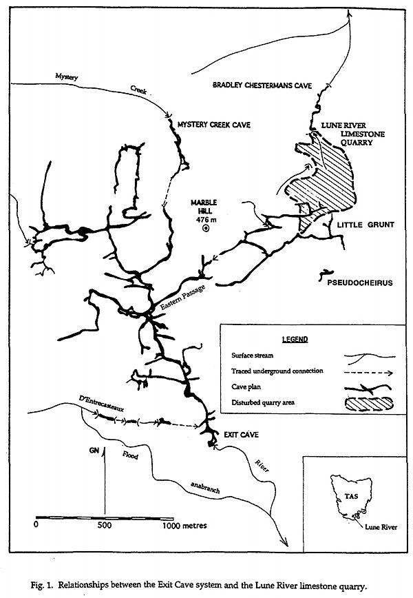
Relationships between the quarry and adjacent karst features are shown in Fig. 1. Before 1991 hydrological relationships between the quarry workings and Bradley Chestermans Cave to the north were well documented. However, although investigations following the extension of the WHA confirmed an even greater likelihood of a direct hydrological connection between the quarry and Exit Cave (Houshold & Spate 1990), this was not proven until positive tracer tests and cave mapping confirmed it late in that year (Kiernan 1991). This positive connection proved pivotal in determining both options for future quarry development and rehabilitation.
The history of the Lune River limestone quarry may be divided into two distinct phases. Before 1975 relatively small quantities of stone were extracted primarily for smelter feed at the Commonwealth Carbide Company works at Electrona. From then until its closure in 1992 the quarry was operated primarily in order to supply large quantities (up to 50 000 tonnes annually) of relatively high grade limestone (85% CaCO3) to the Electrolytic Zinc Company smelters at Risdon. Limestone was used to maintain the pH of molten ore during electrolysis. Agricultural lime (5-6000 tonnes annually) and aggregate for road metal (approx. 2000 tonnes annually) were produced as a by-product of this operation (Baynes 1991a).
Many aspects of the operation of the quarry fell below accepted standards of operation of the time, with obvious impacts on the surrounding karst forms and processes being permitted to continue. Although a very general requirement for site rehabilitation existed in the quarry owner's licence to operate, no detailed quarry development and rehabilitation plan had been drafted prior to 1991.
Vertical faces of up to 40m were left above worked out benches in the eastern quarry with the remains of vertical caves and their contents left exposed in many faces. Topsoil was not stockpiled, rather it was combined with masses of clay residue separated before crushing and dumped in one of two major clay dumps on the eastern and western sides of the workings. These periodically experienced mass failures, resulting in landslides of over 0.5km long reaching from the workings to caves in the valley to the north.
Deliberate dumping and accidental spillages of oils and fuels into sinkholes in the quarry had obvious effects on surrounding caves. Industrial and domestic rubbish had been buried in sinkholes over the years, its breakdown products leaching into cave streams. Prior to closure it was impossible to determine how human faecal wastes were disposed of. Impacts on the Bradley Chesterman system had become so pronounced by 1990 as to have caused the total extinction of aquatic fauna from that cave, previously known to be the habitat of a rare cave adapted form of the Tasmanian Mountain Shrimp (Anaspides sp.) (Eberhard 1990, Houshold & Spate 1990).
In the years immediately before closure the presence of large cavities made it impossible to maintain a benched profile to the upper quarry and in a large measure quarrying consisted of blasting the bases of existing benches and removing stone from the resulting rubble fans. This style of operation made subsequent rehabilitation efforts far more complicated than if an acceptable quarry development and rehabilitation plan had been developed prior to major expansion in the mid 1970s.
During 1991 and 1992 further intensive studies of the geomorphology, cave fauna and hydrology of the Ida Bay karst determined that the quarry was in fact located directly above the headwater passages of the Eastern Passage of the Exit Cave system. Late in 1991 the discovery of a major, 3km long horizontal extension to the vertical pothole IB - 23 (Little Grunt), linking the known Eastern Passage of Exit Cave with quarry drainage, allowed a much better quantification of the extent of quarrying impacts on the Exit Cave system to be made. Unfortunately the difficult technical nature of the entrance (150 vertical metres in ten pitches, many with a vertical squeeze) made it difficult to show the impacts to non-caving decision makers!
Studies confirmed that unacceptable impacts on karst processes, features and associated fauna had already occurred and that proposed plans for extension to the west and south (Baynes 1991b) would dramatically increase the risks of major impacts on the cave system through quarry operations (Kiernan 1991, Eberhard 1992, Houshold 1992).
Briefly summarised, impacts on the Exit Cave system following quarrying have included:
Removal of karst features, including cave passages and their contents
By late 1991 it had become clear that at least the western half of the quarry contributed water to the Exit Cave system at base flow, with the probability that the whole area contributed at high flows. Large vertical caves had been partially excavated in the western part of the quarry in the years of major quarry expansion since the mid 1970s. The most significant of these (eventually named EMP Pot) consists of a series of three vertical pitches with a total depth of 80m, located directly above the horizontal tributaries of the Eastern Passage. The upper levels of this cave, ASF Pot, Exit's Nostrils (named after the significant draught often felt at its entrance) and at least eight other major entrances were known to have been altered significantly, whilst many others had obviously been intersected and backfilled over the years.
The direct effects of blasting on the structure and contents of caves in the quarry was highly variable, depending on the integrity of the rock between the blast site and the cave in question. Within caves in the quarry severe damage both to the structure of cave walls and contents (stalactites and stalagmites etc) were obvious (eg, in Exit's Nostrils, EMP Pot, ASF Pot, etc). Shock waves from blasting were clearly felt by cavers in Little Grunt during blasts, and hydraulic rock breakers could be clearly heard in parts of that cave (possibly air shock waves).
Theoretical investigations suggested that impacts on cave walls could be expected within 200m of the average blast at the Lune River quarry (based on the analogy that unacceptable damage would be expected to occur in Class 1 structures - historic buildings etc) (Baynes 1990). However, Baynes noted that resonance effects on stalactites could not be accurately predicted, and that "where the natural frequency of vibration of stalactites coincides with the principle frequency of the blast, resonance may amplify ground motions by up to 10 times". This may explain why certain speleothems in surrounding caves are broken whilst others remain intact - however many caves in the general area contain broken speleothems at distances far removed from the quarry.
More research is needed in this field as there are no existing standards to predict blast damage to natural features - all predictions are presently based on a loose comparison with built structures (Australian Standard 2187, 1983). Specific research needs to be carried out on the effects of blast-induced resonance in speleothems (if this is possible without damaging significant features).
Increased sedimentation of cave passages by fine clays
Large masses of uniform, highly dispersive, fine grained clays, found within the upper, higher grade limestone beds, presented considerable difficulties for the quarry operators as the grade requirements for customers were often difficult to achieve if the clay could not be separated from the stone before crushing. This was particularly difficult in wet conditions which are common at any time of the year. They also formed a major source of suspended sediment in cave streams draining the quarry.
As may be expected the near-surface beds of limestone in the vicinity of the quarry have been significantly karstified. Many open solution channels are visible in the quarry faces ranging from a few centimetres to many metres wide, generally oriented vertically. An equally large number of channels, and some large, funnel shaped depressions (probably dolines) are seen to be filled with this clay - in upper faces it may comprise 5 - 15 % of the total rock mass.
These fills are derived from soils developed on the Permian sediments which overlie the limestone on Marble Hill. They may also contain a proportion of the silica- rich insoluble residues of the limestone. An analysis of these sediments and cave sediments in the area is presented in Fig. 2. They are probably of Quaternary age - fossil bone assemblages derived from similar deposits within the cave system indicate that species present when they were deposited are essentially similar to present. However, the presence of certain megafauna species including Sthenurus and the locally extinct Forester Kangaroo (Clarke 1987, Muirhead 1990) indicate deposition under a far more open, grassy understory than exists at present, which is indicative of glacial-aged environments in this part of Tasmania.
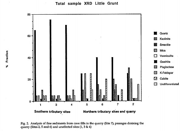
Figure 2
The deposits were exposed following blasting, and large slugs of material entered the cave system immediately after blasting and during subsequent quarrying. Before crushing the limestone/clay mix was forced through a grizzly where much of the fine material was removed. This was then transported to one of two major clay dumps in the eastern and western sides of the quarry. Both of these clay dumps drain steeply to large sinkholes, taking streams which feed Bradley Chestermans Cave. The Eastern clay dump in particular was subject to periodic mass failure with clay and stone rubble flowing at least two hundred metres to pond at the upstream entrance of the cave. At these times large masses of clay were deposited in the cave beyond.
It is difficult to assess the total volume of clay washed into the Eastern Passage of Exit Cave, however at least one kilometre of 3 - 4m wide passage has been filled to a depth of a few centimetres to over 1m at the humanly impenetrable central rockpile. This mass of sediment has had a significant impact on the habitat of aquatic cave fauna, burying speleothems and naturally occurring sediment deposits. It is also a significant source of sulphates dissolved in the cave stream, the concentration of which has been over ten times that of comparable passages (Houshold 1992).
Recurrent turbidity in the Eastern Passage and Exit Creek
Re-mobilisation of the deposited clays has led to considerable turbidity of both the Eastern Passage stream and Exit Creek downstream of the passage junction extending much further into the cave system than the limits of siltation. Levels of suspended solids in the Eastern Passage stream have, at times, been high enough to have had a significant effect on surface fish species (Bradshaw & Chadwick 1980). No information exists on the effects on cave adapted species, however it is generally accepted that cave adapted species usually have a far lower tolerance of artificial environmental change than similar surface forms (Eberhard et al, 1991).
Destruction of palaeokarst fills
The palaeokarst fills exposed in Exit Cave and the quarry record a fascinating history, allowing the genesis of the present cave system to be traced back to Devonian times. A survey of these features (Banks 1994) mapped fills of probable Devonian, Permian, Tertiary and Pleistocene ages. The oldest of these fills have been partially mineralised by fluid intrusions, however the source of this mineralisation is unclear. Stable isotope analysis will provide information on the origin, and possibly the temperature of deposition. This may be linked to warm waters circulating during the emplacement of a granite batholith at depth, or to cool waters derived from sulphide-rich ocean sediments deposited during the Permian marine transgression (Banks pers. comm).
These mineralised fills played a significant role in determining the direction of karstification - most of the major passages of Exit Cave appear to follow palaeokarst fills, suggesting that sulphuric acid generated by the mixing of meteoric waters with sulphides was a major acid source in the excavation of present passages (Houshold 1995). It probably may also help to account for the comparatively large size of many of the chambers (Osborne 1994).
Unfortunately many of these fills were removed during quarrying and dumped along with the rest of the overburden before their true value could be ascertained.
Changes in pH, conductivity and dissolved ion concentrations
The large area of exposed mineralised palaeokarst fill in the western side of the quarry has had a significant impact on the quality of water draining into the Eastern Passage of Exit Cave. The production of sulphuric acid from this part of the quarry following exposure to the atmosphere has increased significantly over natural rates, leading to a decrease in pH in the very headwaters of Eastern Passage and consequently higher conductivity and higher concentrations of most ions, particularly sulphates (150ppm) as water equilibrates further downstream. Whilst no similar impacts have been reported previously, the processes and potential problems are described in Hill (1995) and Kelly (1985).
Re-solution of speleothems by acidified quarry drainage waters
Many speleothems, particularly gours and other rimstones in the streamway at the headwaters of the Eastern Passage have been severely re-dissolved by acidified quarry drainage waters through the processes outlined above. Streamway gours are not common in the Exit Cave system and, whilst these features are a common occurrence in other karsts, their loss at Lune River is a significant one, as well as being an indicator of the overall disequilibrium of the cave stream.
Organic pollution of karst waters
All waste lubricating and hydraulic oils, waste fuel, cleaning agents and human wastes were disposed of on site, generally by draining into gravels over seepage areas, or directly into sinkholes. The Weighbridge Sink in the lower quarry received large amounts of these fluids, as well as used drums and containers, and other rubbish generated on site for many years (Houshold & Spate 1990, Tas. Dept. Environment & Planning 1992). Oil changes were also carried out near the machinery sheds on the crusher bench with waste oil drained directly onto the ground or disposed of nearby. On excavation of the area near the sheds during rehabilitation works tens of cubic metres of oil-saturated fill material were excavated from a large infilled sinkhole.
These pollutants were obviously making their way to Bradley Chestermans Cave where it was often possible to detect strong odours of hydrocarbons. Sewage fungus growing on rocks in the stream suggest that this cave was also the destination of the human wastes generated in the quarry.
It was not uncommon for hydraulic lines to rupture whilst excavation was in progress. Whilst ripping benches many areas of oil-saturated soil were uncovered, with at least two at the mouths of open cave entrances taking reasonable flows after rain.
The main explosive used to blast benches was ANFO (Ammonium Nitrate Fuel Oil). This is a high explosive derived from a mixture of fertiliser and diesel fuel. It was not uncommon for a certain amount of this material to be lost into the karst before it was realised that boreholes needed plugging. Up to 500kg of ANFO was estimated to have been lost into the karst in a single large blast (Baynes 1990). This material is highly toxic to cave fauna.
Reduced densities of indicator species, particularly Fluvidona sp. nov in passages draining the quarry
Eberhard (1992) carried out an exhaustive (and exhausting) study of the densities of indicator species, particularly Fluvidona sp. nov, a small, cave adapted snail, in cave streams affected by quarry drainage, in comparison with those in streams thought not to have been affected by quarrying. Eberhard's results showed a significant difference between snail densities in all habitat types in affected streams as compared with unaffected streams. He attributed lower densities in quarry drainage streams to a combination of siltation of cobble surfaces and interstices reducing both available habitat and opportunities for grazing, and to changes in the pH and dissolved ion concentrations as discussed above. It is likely that direct pollution of cave streams by oils, fuels, ANFO and possibly human wastes also had a significant impact on cave fauna.
REHABILITATION OF THE LUNE RIVER LIMESTONE QUARRY
Rehabilitation strategy
In a last ditch attempt to continue mining on the site, a quarry development plan and environmental management plan (DPEMP) was commissioned by the quarry operator, outlining procedures to progressively develop and rehabilitate the quarry over a 10 - 50 year period (depending on demand for limestone) (Miedecke and Partners 1991). The brief for this plan was developed by the Tasmanian Environment Dept, stressing that the adoption of best environmental practices would be central to the continued operation of the quarry. Following assessment of public comment, this plan was found to be unacceptable to the Commonwealth Environment Dept. (DASET 1992) and the State Environment Dept's assessment concluded that the plan would not adequately provide for the protection and sound management of a world heritage karst system (Environment & Planning Dept, Tas. 1992a).
The Lune River quarry was closed on 20 August 1992 by gazettal of regulations under the World Heritage Properties Conservation Act 1983, following the assessment of existing unacceptable impacts on the cave system and the rejection of the DPEMP on the grounds that protection of the World Heritage values of the karst could not be guaranteed, even with best environmental practices applied (Government Gazette, Aust. 1992). Following closure the first priority was to develop a plan to quickly attenuate ongoing impacts and to re-instate natural processes occurring on the site as far as possible.
Although a reasonable body of literature exists on the rehabilitation of limestone quarries, these deal mainly with the aesthetic aspects of restoration (eg Bradshaw & Chadwick 1980, Gagen & Gunn 1987, 1988, Gunn & Gagen 1989) and the particular difficulties inherent in establishing a vegetation cover (Davis et al. 1993). As far as may be established, this project was the first to attempt to return underlying karst processes to something approaching a natural state, and hence many of the methods are somewhat experimental.
Information
The Ida Bay karst studies (Pemberton & Comfort 1990) and subsequent investigations provided a reasonable general background to significant features and processes in the area (it is unlikely that a similar level of background knowledge exists for any other limestone quarry site in Australia). Before planning could commence it was considered necessary to have a very good idea of the following:
- The nature of the karst processes at all scales, particularly those relating to surface inputs.
- Soil types and thicknesses naturally occurring in the vicinity, and potential topsoil sources.
- Local vegetation communities and potential seed sources.
- Location of cave passages underlying the quarry or receiving quarry drainage.
- Location of recent cave fills and palaeokarst deposits in the quarry area.
- Rainfall records from the nearest local weather station, and some method of compensation to relate rainfall at the site to the station.
- Water quality data for cave streams and quarry discharge.
In the first instance, a general understanding of the nature of the karst system to be replicated was developed using existing data, in order to assess the relevance and completeness of information already obtained, and identify further information requirements. Based on studies already conducted and on analogies drawn from similar areas, we concluded that karst in the vicinity of the quarry consists of:
- a set of diffuse drainage inflow points broadly resembling a polygonal karst inflow system, modelled on the unmodified karst south of the quarry and quarry exposures.
- high secondary porosity at all spatial scales.
- an almost complete absence of overland flow, with most water infiltrating slowly through forest mulch and highly organic topsoils with thin subsoils to fissures in the limestone.
- a very minor component of storm-generated flow into cave entrances.
- an almost complete absence of surface sediment inputs into the karst (apart from events triggered by tree-fall or fire.)
- water quality controlled by CO2 production under a highly variable soil and litter accumulation, and by very slow rates of sulphuric acid production through the weathering action of meteoric waters on subsoil and cave exposures of sulphides.
- a set of air inflow points dispersed according to the cave entrance distribution, modelled on the karst south of the divide.
After analysing the practicality of reproducing these conditions in the quarry, and methods by which this may be approached, gaps in our knowledge were identified and further information was gathered (consistent with heavy time constraints) in order to complete the picture. This included:
Topographical survey of quarry benches
Whilst a quarry plan existed it was out of date in some areas, and the scale of topographic information was too coarse in others. Further levelling was carried out to bring the survey up to date.
Mapping of karst features in the quarry and surrounds
This was important in order to better assess the nature of the pre-quarrying drainage network and to highlight any vulnerable sites requiring protection during the rehabilitation process. Within the quarry, these included such things as cave passages exposed by quarrying and their contents, cave fills and palaeokarst deposits, surface drainage channels and water sink points.
Particularly important was a survey of the untouched karst immediately surrounding the quarry to assess the frequency and separation of major infiltration points. The surrounding area is virtually a polygonal karst with interlocking dolines spaced between 30m and 70m between centres. This spacing was mapped and compared to the separation of major vertical cave passages exposed in the quarry faces and found to coincide reasonably well, given that exposure in the quarry was limited by overburden and the lack of clearly visible faces in some areas.
Further cave mapping
As only a relatively low standard map of the Eastern Passage and its tributaries was available, the Australian Speleological Federation (ASF) was contracted to produce a map of Little Grunt, the Eastern Passage of Exit and its tributaries. A grade 5 map was produced and oriented against the quarry following Global Positioning System and surface theodolite work carried out by members of the University of Tasmania Surveying Department, Russell Bridge of the University of Sydney Engineering Dept. and the surveying division of the Tasmanian Dept. of Environment and Land Management. ASF volunteers also continued a theodolite and Electronic Distance Measurement survey from the entrance of Exit Cave through to the Eastern Passage previously begun by Honours student Glenn Young (Young 1983), in order to close the survey loop. This survey has now been continued through to Valley Entrance and closed by GPS by Danny Ford, as part of his surveying Honours course (Ford 1994).
Further dye tracing work
Whilst Kiernan's (1991) study identified a broad pattern of hydrological connections in the quarry area it was felt that further refinement of the exact destination of flows from various sinking points in the quarry was desirable to determine whether individual flows contributed to the Exit or Bradley Chestermans drainage systems. These experiments were undertaken during medium rainfall events and provided a model for low to medium stage flows.
Further vegetation surveys
These were carried out by Dept. Environment & Land Management (DELM) staff to identify plant species in the immediate vicinity of the quarry, to assess the availability of local seed for the replanting program.
Further soil surveys
Soil surveys were undertaken in the environs of the quarry to identify soil resources available for rehabilitation. A mini excavator was used to open soil pits in suitable locations in order to assess the volume of suitable topsoil available in the area, from sites which would have a minimum effect on karst processes, vegetation communities or other conservation values.
Further water quality data collection
Existing water quality data were collated, however very little information existed on the nature of flows originating within the quarry. Water samples were taken from standing water in the quarry and from flows sinking into the karst system from within the quarry. These were analysed for suspended solids, dissolved major ions, pH and conductivity.
Planning and implementation
When sufficient detailed information had been collected a detailed planning process was undertaken. This involved both theoretical aspects outlined in the written plan, and directions for the plan's practical application, generally represented on detailed maps, plans and conceptual diagrams of the location and construction of the different structures and drainage systems.
Drainage and final bench configurations
Many traditional quarry rehabilitation manuals, and some papers dealing with the rehabilitation of limestone quarries (eg Gagen & Gunn 1987, 1988, Duckett 1989), suggest that before final re-vegetation works proceed the benches should be battered down leaving a rounded profile to bench edges with rubble slopes produced by blasting, creating irregular lengths and heights of benches. This is in order to more closely reproduce the natural contour of the land prior to quarrying. In the highly integrated karst at Lune River this approach had to be weighed against the advantages of retaining the existing bench configuration. It was agreed that, in general, leaving the existing configuration would have the following advantages:
- No further impacts would be created through mobilisation of cave fills and exposure of more palaeokarst fills through blasting and machine work. Many benches sloped back into the hillside, effectively preventing runoff from bench surfaces further eroding clay fans on faces below. Rounding benches and creating rubble slopes would have encouraged the flow of erosive streams over bench edges rather than confining flows to comparatively low energy routes around the bases of faces.
- Water sinking points on the backs of benches could be constructed, allowing a controlled flow of water into the cave system rather than a loss of water from the site, the usual aim of drainage works in non-karst sites.
- Any topsoil applied to the site, or any sediments mobilised through bench ripping could be far better contained by a solid, bunded bench edge than by an irregular, outwards sloping surface.
- The presence of faces up to 40m in height meant that for a re-contouring programme to be of any real use, almost as much material would have had to be moved as had already been removed in the history of the quarry. Clearly this was unacceptable on environmental grounds.
It was recognised that this approach would result in a less aesthetically appealing landscape. However, minimisation of further environmental impacts in combination with the significantly greater control over drainage that it guaranteed made it far more acceptable on ecological grounds, over-ruling purely aesthetic considerations.
Once this general principle was accepted, a drainage system was devised which attempted to parallel the natural system of groundwater recharge in the surrounding karst. It was known that the quarry drains into both the Exit and Bradley Chestermans subsystems. Both cave systems contain cave passages which can be either water-filled or through which air flows freely. The extent to which passages are either water or air filled can vary according to hydrological conditions. The exact variations in watertable height and lateral displacement of drainage divides under different hydrological conditions may never be understood, and certainly may not be predicted with any accuracy. Given this uncertainty, the aim of rehabilitation efforts were to simulate natural conditions of karst drainage throughout the entire quarry.
The nature of karstic flows in the area was illustrated well in some quarry faces, allowing a model of karst drainage to be developed. It was found that, in the vertical plane, karst drainage resembled a tree, in which many small sub-vertical solution tubes gradually coalesced until a major vertical cave was formed (Fig. 3). This process, involving the gradual piracy of small tubes by one large conduit, parallels the accepted process for horizontal cave enlargement described by Ford & Williams (1989), but in the vertical plane. Some major shafts stretch further towards the surface than others, although a zone of thrust faulting marks the upmost penetration of major shafts in the central part of the quarry. In other areas where structural controls are less dominant, large open shafts have penetrated to the surface, giving classical vertical cave entrances. These are particularly common on the contact of a large area of mineralised palaeokarst fill in the western quarry. In fact many of the large vertical caves exhibited some relationship with palaeokarst deposits.
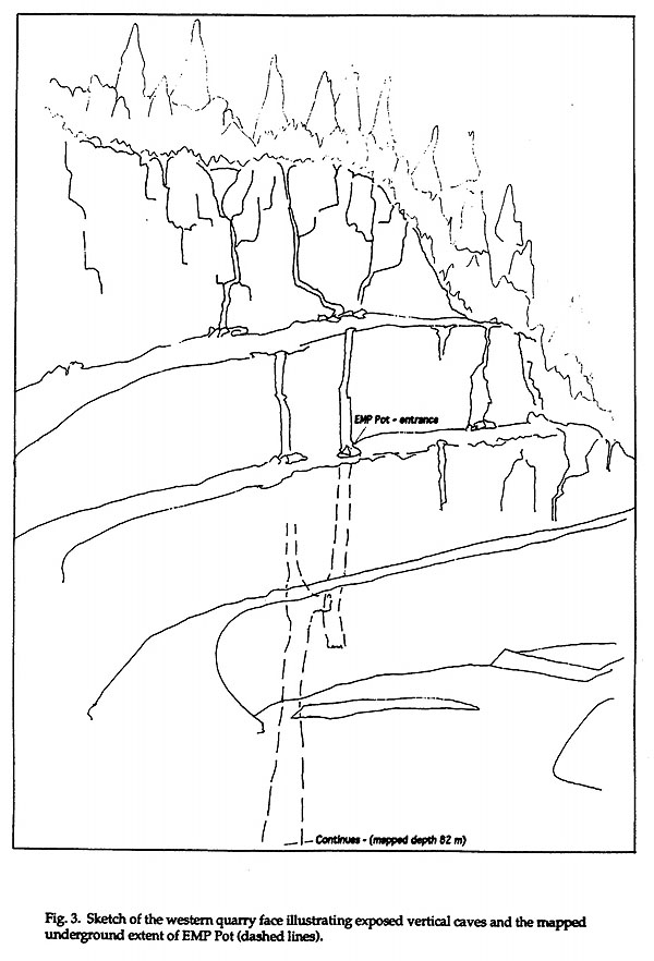
Figure 3
The quarry was divided into numerous small, enclosed compartments, each of around 0.1ha, the size based on distances between doline centres in nearby polygonal karst. Drainage was controlled by a series of bund walls (Fig. 4). A main infiltration point was identified in each compartment, either an obvious cave entrance or solutional passage, or a low point centered on solutionally enlarged joints. Each compartment was to be separated by compressed rock and clay bunds with heights varying between 1 and 2m. The outside of most benches were similarly bunded in order to prevent runoff over bench edges that would initiate erosion gullies. Where benches sloped outwards significantly, filter structures similar to those surrounding inflows were constructed in order to slow water movement before benches were overtopped (Fig. 5).
The size of each compartment varied according to the slope of the bench. In order to maintain internal drainage in each compartment the catchment size of each was calculated in order for all precipitation theoretically expected in a 1 in 100 year storm event to be contained within the bunded area. (This figure was calculated using rainfall events measured at the nearby Hastings weather station and converted according to a conversion factor obtained using two months comparative records at the quarry and the Hastings gauge. As the quarry received consistently higher rainfall than Hastings this approach left a greater margin of error in both the compartment areas and the bund heights). In a very few cases bench slopes were too steep for this to be feasable, and overflow points with drop structures were designed.
Drainage from internal access tracks was diverted inwardly to small catchments rather than being channelled along road table drains to increase in volume and velocity. Ideally, the only surface runoff channels to leave the quarry area would be those few draining the eastern clay dump, the southern side of the road across the main saddle, and possibly the lower section of the main access road.
Stabilisation of clays
The rehabilitation strategy concluded that disturbance of clays should be avoided as far as possible, with drainage to be diverted away from clay areas to avoid any indirect disturbance and remobilisation. The presence of these deposits was also one of the factors influencing the decision not to carry out any further bench reshaping as part of the rehabilitation process. Any further disturbance, essentially for aesthetic purposes only, would have produced an ongoing source of clay to be subsequently deposited within the caves.
The following measures were implemented to achive these aims (Fig. 6):
- Walling and bunding of benches above clay areas in order to divert drainage back onto the bench, to be infiltrated within closed compartments. This was to prevent waterfalls overtopping benches, which were the main cause of erosion of underlying clay deposits.
- Construction of retaining walls at the bases of clay infill areas to prevent further mass movement, with the installation of coarse filter systems at these clay sources. Trials prior to rehabilitation showed that comparatively high energy water flows are common near clay sources. The destabilised fills were also very prone to mass movement following saturation by runoff from above, so the filter would have to allow for the somewhat conflicting processes of transmission of large amounts of water whilst also causing a temporary ponding to allow any fine material to settle out. The inclusion of geotextile or organic materials in these initial traps was shown to detain far too much water, resulting in overtopping and erosion. The best design for this purpose was found to be a wall of large limestone boulders within which 30mm crushed limestone aggregate was emplaced. Surrounding this, arcs of forest mulch and sandy topsoil, and in some cases transverse walls of straw bales were emplaced, in order to slow; any overflows of turbid water, and settle any suspended sediments.
- Clay slopes which were too steep to be mechanically stabilised were treated by hydromulching, involving the spraying of a mixture of pulped paper (newsprint end rolls), vegetable gums as a binder, seed, and in some cases slow release fertiliser.
- The major causes of mass failure of the eastern and western clay dumps were most likely saturation of the slope from runoff above the dumps and from groundwater flows within. Whilst it was suggested that a series of french drains may have been constructed within these deposits it was decided that the disruption caused to existing vegetation on the slopes would not be outweighed by the potential benefits. These drains would not guarantee that groundwater flows within the dumps would in fact be trapped, as their exact location could not be identified. Therefore, no drainage works were carried out on clay dump slopes.
- To alleviate the problem of surface runoff all road drains (which previously had discharged onto the dumps) were diverted away from the dumps, and deep drainage lines were excavated along the tops of the dumps to quickly drain surface water away from potentially unstable sites.
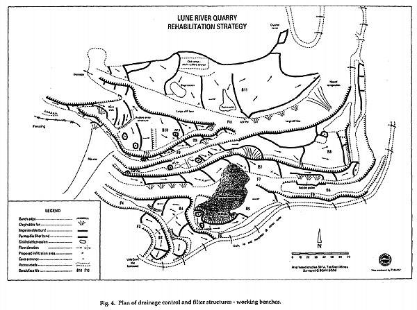
Fig 4a
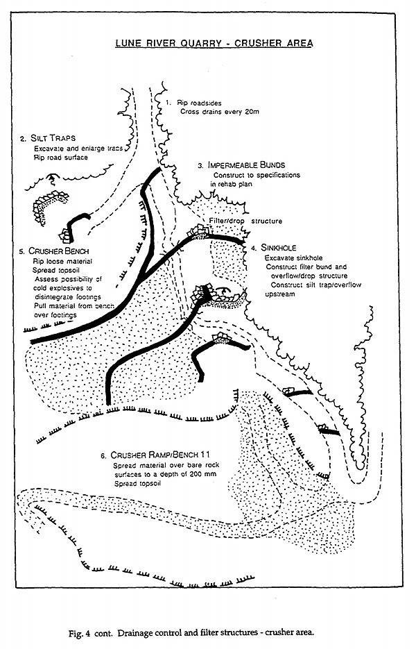
Fig 4b
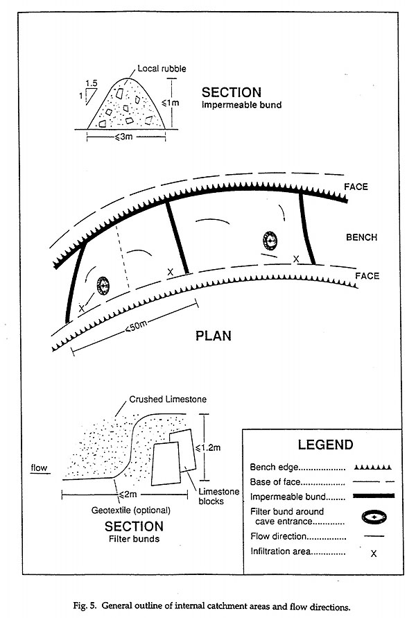
Fig 5
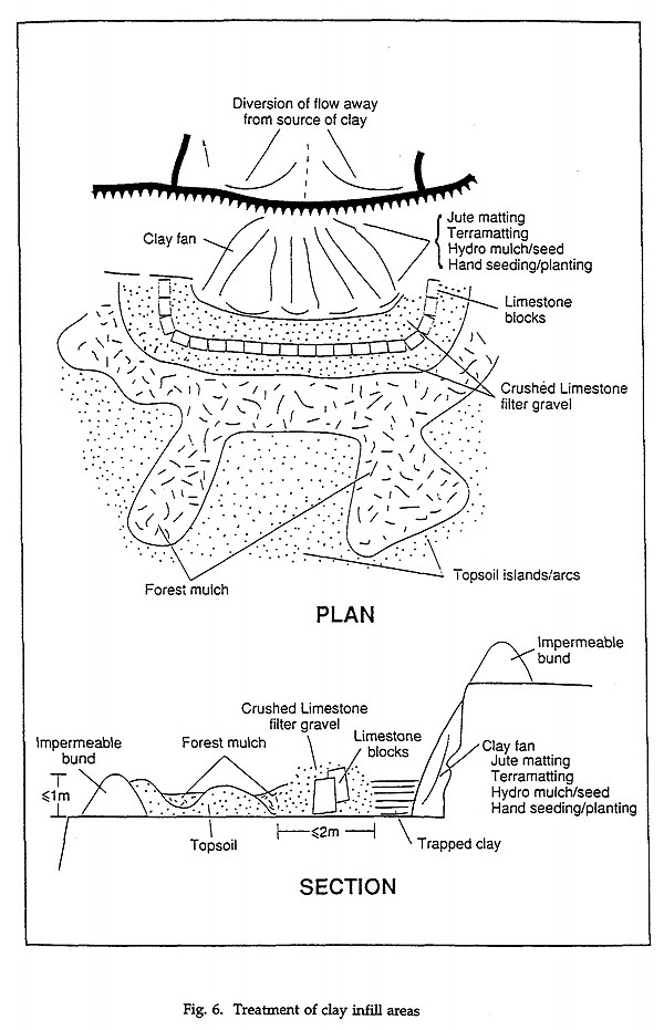
Figure 6
Treatment of exposed solution channels and cave passages
As shown on Figure 4 at least twelve major cave entrances were mapped on quarry benches during the initial investigations. More had been reported in the past, although most of these had been filled to maintain a level bench surface. More were found when bench surfaces were ripped to relieve soil compaction. These openings were the main channels by which heavily silt-laden water was transferred to the cave system below and as such, formed the focus for filtration of water.
Whilst a major objective of the strategy was to trap as much mobile sediment as possible at the source, the extremely fine nature of the clays, the fact that some bench surfaces were to be ripped, and the decision to use topsoil on many benches meant that a final filter system had to be emplaced before surface flows went underground. In order not to affect air circulation it was decided to leave cave entrances open, however to do this a method had to be devised which allowed both air and water to freely pass, whilst leaving any suspended sediments or emplaced topsoil, mulch etc on the bench.
A series of filter and retention structures were tested on a lower quarry bench, utilising various combinations of materials. Materials available in bulk and at a realistic cost included: clean crushed limestone of various grades (crushed on site from limestone stockpiled before closure), various geotextile fabrics, Eucalyptus bark from local sawmills and chipmills, forest mulch derived from powerline clearance operations by the Hydro-Electric Commission (HEC) or mulch produced by the HEC mulcher from local forest sources, pea straw and sterile oaten straw from a local supplier. These structures needed to freely transmit water in order to reduce hydrostatic pressure and hence possible failure of the sructures themselves, whilst trapping as much as possible of the sediment behind.
Following construction, plastic sheeting was installed below the filters to trap water samples for sediment analysis. Large drums were filled with water and saturated with clay obtained from the workings above, and topsoil similar to that proposed for application to the benches. These were emptied at a steady rate through the filters, and water samples trapped in the plastic sheets were analysed for suspended solids concentration and grain size.
All combinations of filter failed to remove the majority of fine, almost colloidal clays if constructed without ponding the water prior to filtration. However, the designs incorporating geotextile cloth significantly dammed back flows, allowing some time for settlement. These designs also trapped the great majority of sandy silt sized topsoil particles, which washed through other designs. Measurement of flow rates and quantities of suspended sediment in the discharge waters showed that structures consisting of large limestone blocks surrounding the area or streamsink to be protected, followed by a layer of 20mm crushed limestone, a single sheet of 'Bidim' woven geotextile, a further layer of 20mm aggregate, a barrier of straw bales, and a 3m thick arc of forest mulch/Eucalyptus bark provided the best filter for sediment just prior to entering streamsinks.
Construction of the filter system finally chosen consisted of the following procedures and materials (Figure 7):
- Each site was assessed as to the possibility of using a low area to pond water prior to it entering the filter. Where possible, attempts were made to channel runoff into this area.
- Using a loader or excavator bucket, as much loose material was cleared from around the entrance as possible. The flat bedded limestone at Lune River made this task reasonably easy.
- Large limestone blocks (of sufficient mass to withstand any flow or mass movement, and high enough to avoid overtopping) were placed at a distance of 2 - 3m around the entrance, downstream of the ponding area.
- The upstream side of this wall was coated with <30mm crushed limestone aggregate, as a bedding for 'Bidim' geotextile (heavy gauge) which was then overlain and lapped onto the bench. This was then sandwiched under a further 1 - 2m thickness of limestone aggregate.
- Straw bales were interlocked on the upstream side of the aggregate, and coated with large quantities of Eucalyptus bark and forest mulch. Coating the bales was necessary to discourage ravens which had the habit of totally dismantling unprotected straw bales for reasons best known to themselves. Mulch arcs were then extended up to 10m horizontally onto the bench, interlocking with topsoil mounds. In some cases futher arcs of straw bales were emplaced to reduce flow velocity before the filter.
Crusher and weighbridge site
Whilst machine work and initial re-vegetation of the working benches was complete by December 1993, removal of the crusher, weighbridge and associated buildings and infrastructure from the lower benches was not complete until late 1994. Rehabilitation of these sites was carried out in March - May 1995. These sites in the lower part of the quarry presented special problems not encountered on the working benches. These areas contained the workshops, plant rooms and machinery sheds used to house and maintain plant and equipment. The sites were also used for rubbish disposal. The main sources of organic pollution of the karst system was centred on these areas, as they received all of the used oils, drums and other refuse associated with the operation.
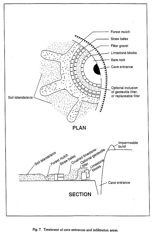
Figure 7
When a shed containing the transformer for 240V power was removed the ground was disrupted to such an extent that the entire flow of a roadside gutter draining the quarry disappeared underground, even after the largest rainfall events when tens of litres/second were flowing. This led us to believe that a substantial cave existed here. Whilst excavating the loose material contained in the cave entrance it was discovered that transmission and engine oil, drained from machinery at service times over many years at a nearby plant shed, had saturated the doline fill with oil. It is highly likely that this was slowly leaking into the karst drainage.
Many cubic metres of contaminated clays and gravels were removed from the doline, exposing the cave entrance. It was impractical to transport this material to another landfill site, so it was combined with other loose material to form bund walls in the lowest area of the quarry, most remote from any likely input to the Exit Cave drainage, reasoning that exposure to the atmosphere and dispersal would allow reasonably effective bioremediation.
Additionally, a massive reinforced concrete slab was discovered, forming an apron to the crusher, bridging many areas of subsidence near this sink. This formed an impervious surface which had to be broken up in order to allow infiltration and root penetration. Removal of this material would have been practically impossible, so it was broken up with a hydraulic rock breaker and buried on site.
Following bunding of the upper quarry benches and construction of four silt traps on the main quarry access roads, the discharge of the main drainage stream was considerably reduced but not eliminated. The object of retaining all flows within the disturbed area was not therefore entirely attained. However, as vegetation re-colonises it is hoped that more detention and infiltration will occur on the benches. In the short term though, storm flows carrying suspended load still discharge here. For this reason three more large silt traps, again consisting of a limestone block foundation veneered with limestone aggregate, were constructed along its course to slow flow velocity and to allow suspended sediments to settle.
During rehabilitation works the weighbridge site was also shown to be contaminated with hydrocarbons - another oil dump site was located near another machinery shed. After an examination of water and hydrocarbon discharge rates the Environmental Management Division concluded that disturbance to this site could cause a large slug of hydrocarbons to be liberated and flushed through Bradley Chestermans Cave. They therefore recommended that the surface of the site be cleaned up as best as possible, but to allow the existing landfill to remain, relying on natural processes to remediate the pollution (Dept. Environment & Planning, Tas. 1992b, 1993).
Roads
Where possible, haul roads were deeply ripped using an excavator bucket rather than a dozer which would have channelled water downslope. The gradient of many of the roads made it unwise to apply topsoil to most of them. Deep (~1m) cross drains were excavated at 20 - 50m intervals directing drainage to either vegetated areas or internal drainage compartments. In a few cases drainage was directed outside the disturbed area into stable surrounding forest in order to prevent flows overtopping quarry faces.
Internal haul roads were ripped during initial machine work in 1993. The western haul road was rehabilitated along with the crusher area in 1995, leaving the eastern haul road open for three years in case any major machine work was necessary in the event of large-scale failure. Following a one in forty year storm event in February 1996 investigation of all structures indicated that failures are not likely to occur in the near future, and the decision to rip, drain and rehabilitate remaining roads was taken in March 1996. The main access road and the eastern haul road were rehabilitated in May - June 1996. A foot track, connecting the main gate with the track to Exit Cave, was constructed along this route to allow cavers access to entrances south of the quarry and to allow seedlings to be carried in to replace any failed plantings.
Safety issues
As machine work progressed, and prior to any manual work commencing, negotiations with the State Mines Inspector were necessary in order to establish that the quarry was left in an acceptably safe state. This was a requirement of the Mines Inspection Act 1968 in Tasmania, and similar legislation applies in other states. It was agreed that a combination of removal of all loose rocks from bench edges and the construction of gates, fences and warning signs at key access points was sufficient to comply with provisions of the Act.
As blasting in the quarry area had been prohibited by Commonwealth regulations, all rock had to be removed by hand or mechanical means. By far the most efficient method was the use of a 30 tonne excavator with a long arm. This machine, where possible, was used to claw stone back onto the bench, although some loose areas could only be reached from below. In inaccessible areas stone was hand picked from bench edges. Most of the stone cleared in this way was subsequently used for the construction of filters and retaining structures, whilst some was crushed for filter gravel.
Re-vegetation
Following the instatement of an acceptable drainage and filtering system, re-establishment of native vegetation was the next major task. Whilst machine work was being carried out a re-vegetation team was engaged in obtaining local supplies of seed and mulching materials. A combination of direct seeding, slash spreading and planting of seedlings was used in the re-vegetation programme (Batchelor 1995).
Topsoil extraction and spreading
The structure and nutrient status of the gravelly clays covering benches was found to be almost totally unsuitable for plant growth, so it was decided that topsoil would be selectively applied to those benches requiring a quick vegetation cover. Soil surveys in the surrounding area were carried out, attempting to locate a source of organic rich, sandy soil capable of supporting plants, allowing rapid infiltration of water and acting as a final filter for suspended sediments. A mini-excavator was used for this work. This soil type would have naturally occurred on the western side of the quarry at least, where relatively coarse grained Permian tillites would have provided the majority of parent material.
A thick deposit of this soil type was located approximately 1km from the quarry where peats overlay thick sand deposits derived from glaciofluvial outwash from the nearby ranges. Up to 2m thickness of organic soil overlay glacial tills and glaciofluvial gravels, capped by an organic horizon up to 0.5m in thickness.
Two soil pits were opened here, however prior to excavation the Leptospermum/Melaleuca heath overlying the soil was slashed and sent to Forestry Tasmania kilns in Geeveston for seed collection. Some slash was also stockpiled to be spread over the soil pits when extraction was complete.
Soil was excavated using 30 tonne excavators initially loading ten yard trucks for transport onto benches. The peaty topsoil was mixed with the sandy substrate using the excavator before loading. As each compartment was constructed the bunds were emplaced, the bench surface ripped, clay retaining structures and filters built, and soil was dumped and roughly spread using either a front end loader or 30 tonne excavator. Each compartment was finally sealed with a bund. In this way soil spreading, filter construction and drainage works were integrated. Soil excavation was carried out over two seasons, as the onset of cold, wet conditions meant that not all of the soil could be excavated in the first year.
When excavation was complete at the end of each season both pits were re-graded and a 200mm layer of topsoil spread evenly over the sites. These were then covered with slash and hand seeded using the seed collected previously. Fertiliser was also hand spread.
Seed collection and direct sowing
Seed collection was carried out in two main phases, because of the seasonal availability of certain species. Bedfordia salicina, Cassinia aculeata, Acacia melanoxylon, A. verticillata, Gahnia grandis, Eucalyptus obliqua, E. nitida, and small quantities of Melaleuca squamea and Leptospermum scoparium were collected in late summer 1993. This was supplemented from stock collected as part of ongoing annual seed collection programs carried out by the PWS Land Rehabilitation Officer and staff. A total of 66.3kg of these species was collected at this time.
The majority of Melaleuca squamea and Leptospermum scoparium were collected in June 1993. Slash was collected from nearby healthy scrub, with approximately 1200kg of slash yielding 88kg of uncleaned seed after extraction in the Forestry Commission kiln.
Approximately 1.5kg of E. obliqua and 1kg E. nitida were purchased from local suppliers collecting in nearby forests.
Approximately 800 g of Gahnia grandis seed were collected. Whilst actual cutting of the seed heads was relatively easy, extraction of the seed was time consuming, with the seed heads requiring heavy threshing and shaking.
Acacia melanoxylon pods were collected either from the tree or underneath, and were relatively easy to extract.
Seed were sown either by hand or as part of a hydromulching program. Hydromulching consisted of applying a mixture of paper pulp (clean roll ends from the Mercury newspaper not containing printers ink), vegetable gum binder, fertiliser (slow release 'Agroblen' or 'Osmocote') and seed (sterile ryecorn for fast stabilisation and mulch production, Acacia verticillata and Eucalyptus obliqua). A large truck-mounted mixing tank supplied the mixture via a high pressure pump and hoses to faces and fans too high or dangerous for hand application. The mix formed a rain-resistant coating on the faces as well as mulch for the seeds, and was effective in slowing rainsplash erosion. It was ineffective in areas where slumps were initiated by seepage or high soil water pore pressure.
The remaining seed was cleaned, mixed and hand spread between May 1993 and May 1996 according to the stage machine work had reached. The Acacia seed was kept separate and treated immediately before spreading by pouring boiling water over, standing for 2 minutes, draining and flushing with cool water. This was then added to the cocktail, and the whole bulked out at the rate of 1:10 with old (70 years) sawdust.
Topsoiled benches, ripped roads, accessible clay fans and other bare areas were all treated with the same mix, at a rate of approximately 6kg/ha, which is a a heavy rate.
Some areas where regeneration was poor were re-seeded two years after the original 1993 treatment, and the soilpits were given a final treatment when the decision to finally cease soil extraction was made in 1995. The rest of the seed cocktail was spread on remaining poor areas, on ripped roads and soil pits at the conclusion of major works in June 1996.
Mulches
A range of different mulches were applied to the site, selected for their properties as filter media for water entering caves, for protection of seedlings and for soil enrichment. Materials included scrub slash, chipped forest mulch from a portable mulcher, oaten straw, pea straw and Eucalyptus bark from local sawmillers.
1.5m lengths of Leptospermum and Melaleuca slash were hand cut and applied directly to the benches, both following seed extraction in the kilns (many seeds were found to remain in the capsules) and direct from collection. This formed the main source of mulch on the benches and was most successful in both initiating seedling growth and protecting young seedlings.
Forest mulch and bark were both used primarily as part of the filter structures, separating straw and crushed rock elements from topsoil. They were also used in some areas to surround seedlings and to add organic matter to ripped surfaces which were not topsoiled.
Bales of sterile oaten straw were also used in filter construction, and many were placed perpendicular to the slope of benches in order to restrict sediment movement within individual compartments. Pea straw was used as a mulch for individual seedlings.
Propogation and planting of seedlings
Seedlings were planted in three main phases - in the latter half of 1993, Autumn 1995 and Autumn/Winter 1996. The initial plantings were propogated from seed collected in 1993, consisting of approximately 3000 Eucalyptus obliqua and 10 000 Acacia verticillata. These were planted using only hand tools, initially at a spacing of approximately 2 - 3m. Eucalypts were planted in areas of good soil depth, adjacent to bench faces, on unstable clay dumps, and in areas requiring screening from remote viewpoints. Acacias were planted on shallower, poorer sites, particularly those which were not topsoiled, considering their nitrogen producing capacity. Holes for seedlings were dug with lightweight mattocks, and approximately 40g of slow release fertilised was placed in each hole and mixed with the soil before planting.
Heavy browsing by herbivores, particularly in the upper quarry, led to losses as high as 50% in the first few months. These were replaced where necessary with seedlings from the initial germinations. By late 1994 it had become obvious that local fauna had a distinct preference for nursery raised stock. Losses, particularly in the upper quarry, were so great as to reduce the number of tall species surviving to less than 20% of that originally envisaged. Further plantings in these areas were made in Autumn 1995, with 1000 Eucalyptus obliqua seedlings protected by 600mm high plastic tree guards held in place with hardwood stakes. At this time mechanical work in the old crusher and weighbridge areas was progressing, and planting and seeding of these areas took place shortly after. Approximately 2 000 each of unprotected Eucalyptus obliqua and Acacia verticillata were planted then, hoping that the distance from the bushline and presence of steep faces would minimise browsing losses.
Although the spiney Acacia verticillata did very well in the cool, wet summer of 1995/6 the unprotected Eucalyptus plantings were almost completely wiped out by grazing. Again, plastic tree guards had to be used to protect E. regnans and E. obliqua seedlings which were used in the final plantings in June 1996. These plantings replaced seedlings which had failed in the earlier tree guards because of drought or frost, filled in poor areas on all benches, and along the eastern haul road and the main quarry access road. In these places individual holes were filled with approximately 5 litres of topsoil before planting and protection, as earlier plantings in untreated ripped road formations had not thrived. Approximately 3 000 Eucalyptus seedlings were planted at this time.
Whilst the quarry now has an acceptable cover of a good mix of species, it is likely that further losses from frost and drought will occur in the future. Although no further mass plantings are required it may be necessary to replace failed individuals within established tree guards - a relatively simple task.
Use of fertilisers
Fertiliser use was strictly controlled in the re-vegetation program, as very little research has been carried out into the effects of artificial fertilisers on cave ecosystems. However, it has been shown that the application of nitrogenous fetilisers, particularly those containing ammonia, may have an effect on dissolved oxygen levels in cave streams sufficient to cause a significant decrease in populations of cave invertebrates (Lewis 1982, Vandike 1982, Aldwell et al, 1988; Mitchem et al, 1988; Hardwicke et al, 1989). Actual levels of fertiliser application would be very difficult to predict, given the individual variance between sites. However, at Lune River a general leaching model (Burns 1975) was used to predict the effects of various nutrient sources on cave streams.
A theoretical maximum acceptable value of 1.5 ppm NO3 - N in cave streams was adopted following a review of relevant literature (Gillieson & Houshold in press). Application rates were then calculated from Burns' model, with the following guidelines established:
- A maximum application rate of 125 kg/ha of combined fertiliser for the entire quarry.
- Nitrogen to be applied only in the form of a slow release fertiliser ('Osmocote', etc).
- No fertiliser to be applied to the immediate catchments of streamsinks or anywhere near flowing water.
Monitoring has subsequently revealed that NO3 - N has never exceeded 0.6 ppm in the Eastern Passage stream, and that populations of key indicator species have increased following rehabilitation.
A fertiliser - free control area was set aside encompassing topsoiled, ripped and untreated areas in order to compare the effects of fertiliser application with unfertilised sites. After one year there is a very obvious difference between treated and control sites, particularly with regard to seedlings germinated from broadcast seed. The unfertilised site has good growth in both A. verticillata and E. obliqua, however Cassinia sp, Senescio sp, Gahnia sp and others are as yet very sparse. These understorey species are growing rapidly in the fertilised sites. However, the main test of the method will come in the future when all artificial fertiliser has been released. At that stage the (presumably) hardier plants (with a greater root/shoot ratio) on unfertilised sites may possibly then become dominant.
Higher rates of fertiliser application - up to 250 kg/ha - including the use of relatively inexpensive, fast release N-P-K combined fertilisers, have been made in areas away from the karst such as disturbed roadsides leading to the quarry and the soil pits. This was to encourage rapid re-vegetation of visually sensitive ares which posed no threat to karst processes.
Applications of fertiliser have been made yearly following initial works in 1993. There are no further plans for widespread application, however restricted applications may be made in poor areas.
PHYSICAL AND HUMAN RESOURCES
Personnel
A wide range of people have been involved in the rehabilitation process. Planning was multi-disciplinary, involving specialists in karst management and environmental rehabilitation, hydrologists, geomorphologists, botanists, biologists, foresters, professional land surveyors and recreational cavers with personal expertise in many karst-related fields. The planning process was overseen by a steering committee of officers from Tas DELM , the Commonwealth Dept Arts, Sport, the Environment & Territories (DASET) and an independent karst expert.
Machine work on site was carried out initially by employees and subcontractors of Benders Spreading Services, supervised by a foreman and engineer from the Tasmanian Dept of Construction. Continuous liaison was required between plant operators, supervisors and the Parks & Wildlife Service (PWS) Karst Officer who had responsibility for implementing the plan. It was vital for this interaction to take place daily as many of the concepts involved were not familiar to supervisors and operators. Later phases of machine work were carried out by Hazell Bros (Construction) under the direct supervision of the Karst Officer.
Re-vegetation was undertaken initially by a team of ten local people employed under a Federal Jobskills program, supervised by PWS Rangers, the PWS Land Rehabilitation Officer and the Karst Officer. Later seeding and tree planting operations were carried out by teams of between two and four local contractors employed and supervised directly by PWS officers.
Machinery
Given the restricted working area on quarry benches, and the often wet and boggy conditions experienced, the most versatile machines used on this job were the 30 tonne excavators with rock and mud buckets and a hydraulic rock breaker. The rock bucket was used to build and compress bunds, transport materials for and construct filters and retaining structures and to rip benches and roads. The mud bucket was used to extract topsoil. The rock breaker was used to break up concrete slabs and shape boulders for use in retaining structures.
A D7 bulldozer was used to stockpile some loose materials on benches but was of only very resticted use in ripping and bund construction, as rips were linear and had to be made downslope - which often channelled water.
4WD articulated front-end loaders were useful in constructing impermeable bunds as loose material could be both transported and compressed using the bucket. Their large capacity and higher speed made them more efficient in some cases than the excavator. As with the dozer, the loaders were of little use in bench ripping.
Ten-yard tip trucks were initially used to transport topsoil onto the benches, however many punctures, boggings and other mechanical failures indicate that these were not ideal for work in such rough terrain. Later, 6WD articulated dumpers were used, being far more manoeuverable and robust.
The truck mounted hydromulching/hydroseeding equipment was very satisfactory for reaching sites up to 20m above the ground. Up to 200m of hose could be attached to reach places away from the immediate vicinity of roads.
For revegetation works a 300kg capacity motorised barrow was extremely useful for transporting stakes, topsoil, fertiliser bags etc over surprisingly rough terrain. The rubber caterpiller treads allowed very steep slopes to be climbed, although the narrow track often made spillages difficult to avoid.
Monitoring
A monitoring program was implemented in order to assess the effectiveness of rehabilitation measures on both the surface and subsurface environments.
Surface monitoring includes regular visual observation of bunding, sediment movement and filters, species maturity, diversity and ground cover. A set of 45 fixed photomonitoring sites were installed with initial recordings at 6 monthly intervals being taken. Now that vegetation has established to an acceptable level, yearly photographs will be taken.
During the three years following completion of the original machine work very little remedial work has been necessary. A miscalculation of the likely volume of one large clay mass allowed approximately 10% of the mass to overtop a retaining structure after the slope failed, spilling onto a bench approximately 75m above an open inflow cave. This was remediated to some extent by the placement of dams of straw bales across the bench to act as stilling dams. These will require constant topping up as silt settles behind them, and as the straw breaks down. Various other minor leaks of clay have been slowed by hand shovelling of filter gravels and hand placement of geotextile.
An early concern was that the geotextile used in filter structures would eventually clog with fine sediments, allowing overtopping and erosion of filters. This has not occurred in the three years following construction, as far less movement of sediment and topsoil has taken place than was originally envisaged. This is mainly due to the effectiveness of clay fan stabilisation and the rough, hummock-and-hollow nature of the restored soil surface.
Vegetation monitoring.
In combination with photomonitoring, vegetation re-establishment has been monitored by estimating the percentage cover on each bench by understorey and canopy species. Although similar plantings and seedings have been made over the entire site, differences in germinations and success of various species of seedlings are striking. Dominant controls are primarily the quality of substrate and secondarily such things as aspect, exposure to sun, wind and frost, and the type of drainage. Numerous species have established independently of plantings, particularly Cassinia and Senescio derived from the immediate surroundings.
By winter 1996 an acceptable concentration of both understorey and canopy species had been established. Vegetation cover has now essentially stabilised all topsoil and clay movements apart from that described above, following the overtopping of the structure on bench 7.
A surprising number of invertebrate species, both aquatic and terrestrial, have established on the site, as have many native herbivorous mammals!
Water quality monitoring
Sub-surface monitoring stations were established to automatically monitor changes in water quality at three sites:
The Eastern and Western Passage streams: The Eastern Passage site was chosen as it was the most easily accessible of the streams heavily affected by quarry drainage. The Western Passage stream was chosen for a qualitative comparison as its catchment has remained in an essentially natural state, escaping even selective logging early in the century (which was carried out over most of the eastern and southern slopes of Marble Hill). It was considered most likely to reflect the nature of the Eastern Passage prior to quarrying.
These two sites consist of fixed dataloggers, initially recording changes in conductivity, pH, turbidity, temperature and stage at half hour intervals. Lead acid gel cells initially used to power the equipment unfortunately failed after less than twelve days given the average cave temperature of 9.5 - 9.7°C, making this regime impractical to service, as a twelve hour day for two people was required to service the sites. Unfortunately the replacement of the gel cells with far less environmentally acceptable alkaline D cells and extending the sampling interval to one hour made little difference to the service interval, with an eighteen day interval being the maximum possible between services. At times the cave streamway is inaccessable because of floods so some data gaps occur in this record.
Unfortunately the contractors who designed and built the equipment to suit the monitoring schedule required by PWS had not, as they had promised, tested the equipment in a temperature controlled lab before installation in the cave. This testing was to enable the meeting of an agreed requirement of a minimum monthly servicing regime, given half hour sampling intervals. The decision to install the equipment in the absence of these tests was an error of judgement which should not be repeated. Given this overall restriction, the apparatus has performed reliably for over two years, the only requirement being a relatively rapid (~6 monthly) replacement of sealed pH probes because of contamination. Sealing of electronics in an air tight container and the very liberal use of fresh silica gel at all service times has been particularly important here.
Whilst gaps exist in this record it was soon realised that base flow conditions at both sites are quite consistent and reliable, with major changes to water chemistry and suspended solids occurring only after medium to large scale flood events. Given the difficulties with the monitoring equipment it was decided to base the monitoring approach on a comparison of the effects of similar magnitude flood events separated by time. Although only a few such comparable events have occurred to date it is obvious, even in a qualitative sense, that graphs of parameters such as turbidity and conductivity are becoming far less peaky over time in the Eastern Passage (Figure 8). The broad shapes of graphs are approaching that of the unaffected site in the Western Passage which have remained essentially constant. Presumably, this levelling and lengthening of turbidity and conductivity peaks may be explained by the more controlled and diffuse infiltration of clean water in the quarry, the cutting off of sulphide-rich fine clay sediments prior to infiltration, and the equilibration of exposed sulphides in the quarry face as oxidation rates have slowed down since rehabilitation.
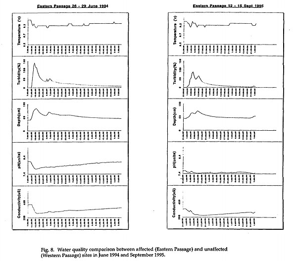
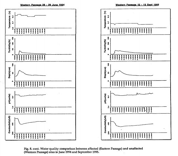
Figure 8
The Exit Cave stream close to its outflow into the D'Entrecasteaux River. This site was established in order to assess the effects of rehabilitation on the entire subterranean catchment. Conductivity, pH, dissolved oxygen, temperature and stage are recorded here using an integrated, submersible YSI 6000 environmental monitoring system. The turbidity probes which were promised by YSI distributers at the time of delivery are, unfortunately not available without major modification to the existing sondes. Whilst these were envisaged at the outset of the programme, and would have proved very useful, the cost of converting the old sondes is now considered too extravagent to proceed. Two individual sondes are employed, swapping each at servicing times in order for downloading, cleaning and re-programming to take place in the lab.
Unfortunately very little baseline data was collected at this site prior to rehabilitation works, and no suitable comparative site exists, so trends in water quality here may only be assessed after many years monitoring. Records from this site are too preliminary to be discussed at this stage.
Once installed in a frame which would withstand the sometimes cosiderable flows of an Exit Cave flood, these monitors have proved extremely reliable, their 8 alkaline 'c' cells reliably powering the instrument for at least one month with half hourly sampling intervals. Electronic calibration has extended the life of pH probes considerably, and thorough cleaning of all probes at service times has prevented significant deterioration of DO and conductivity units.
Fauna monitoring
Following seasonal assessment of annual variation, cave fauna monitoring has been carried out annually, consisting of the establishment of fixed quadrats in various environments in affected and unaffected streams. Counting of key indicator species in these sites indicates that abundances in affected sites are growing, following improvements in water quality as documented by the water quality monitoring programme. For a full discussion of the significance of these findings, refer to Eberhard (1995).
Further investigations into the natural variability of key species and ongoing relationshiops between biological and geohydrological processes will be continued, subject to the availability of funding.
CONCLUSIONS
Monitoring and further exploratory work in the Exit Cave system following closure of the quarry have highlighted the wisdom of the prompt cessation of mining in 1992. Karstic connections between the quarry and the cave system have been shown to be far more direct than was envisaged (by opponents to quarry closure at least) during the extremely limited timeframe available for investigation of impacts prior to the closure decision.
Whilst many of the methods outlined above have been somewhat experimental, they were based on sound geomorphic and hydrological principles, applied to a reasonably complete knowledge of the nature of the karst system in the vicinity of the quarry and the tributary passages of Exit Cave. The acquisition of this information and advice, and drawing the attention of decision makers to the significance of and threats to the karst system, could not have been made without considerable effort by many volunteers, who supplied tens of thousands of dollars worth of voluntary labour. These people, with an extremely wide background in academic, management oriented and recreational aspects of speleology, provided the base on which an assessment of the nature of features and processes which were threatened and which were to be replicated during rehabilitation, could be made.
The results of this project may be applied to karst systems in similar geomorphic settings in other locations. Particularly important principles learned here include:
- The style of rehabilitation for quarries in karstic areas should be primarily determined by the degree of integration of karst hydrology and atmospherics. Lune River is a highly integrated system; others are less so. Vertical and horizontal elements in different karsts are highly variable, depending on relief and associated environmental controls. Relationships with surrounding catchment processes are also highly variable. An autogenic system will require an entirely different rehabilitation strategy to an allogenic system. Whilst the general principles of this project may be applied to others, unquestioning imitation of specific details will most likely lead to problems.
- Detailed investigations of karst and associated biological processes must be carried out in the quarry surrounds before rehabilitation commences, in order to replicate natural processes. Many of these requirements for Lune River are listed in the rehabilitation strategy section, above. Other sites with different ecological relationships will doubtless require the investigation of different parameters.
- A major focus in any project will be the restoration of the karst hydrology, including both drainage patterns and water quality. At Lune River, the natural polygonal karst network was replicated at all scales following the principle that all water falling on the site should remain on the site prior to infiltration. Simulation of internal drainage basins, dolines and minor, structurally controlled infiltration points was achieved through the use of a wide variety of locally available materials and techniques. At other sites, initial conditions will be very different - planning should be very much driven by local karst characteristics.
- Stabilisation of erosion-prone areas as close as possible to their sources, trapping and final filtration of water prior to entering cave systems must be central to all programs, in combination with an assessment of how atmospheric processes are to be re-established in an essentially natural state.
- A greater degree of primarily aesthetic restoration may be possible in karsts where restorative blasting will not intersect or affect further caves or karst processes, at the expense of control over the restoration of processes. This will remain a very difficult parameter to predict with confidence and as such all plans should err on the side of caution.
- Often, in older operations, karstic conduits will be found to be contaminated with hydrocarbons from either accidental or deliberate spillage. Procedures must be formulated to deal with such contaminated materials.
- Current legislation generally requires that safety issues must be dealt with, taking a long term view following decommissioning of quarries. Often traditional methods used to reduce perceived danger are at odds with requirements for environmental aspects of rehabilitation. Strategies to reconcile these differences should be developed as early as possible prior to rehabilitation.
- Successful revegetation of benches was found to depend primarily on the quality of substrate used. Whilst it would have been totally inappropriate to use topsoil in certain sensitive areas, the use of a sandy, organic rich soil from a local source was found invaluable in establishing both trees and understorey species which will now play a very important role in runoff detention, sediment stabilisation and restoration of water chemistry. Careful monitoring will be required, as surface collapses may occur in areas previously thought not to be at risk from subsidence. Sufficient materials must be readily available to create emergency and/or permanent filter structures if necessary.
- The most efficient method of re-vegetation consisted of spreading brush slash for understorey species. Direct spreading of seed extracted from local sources was the next most efficient, and met with good success for understorey species and limited success for trees. It was found that trees germinated from direct seeding were far more resistant to browsing and exposure than nursery raised seedlings which were time consuming to propogate, plant and protect from browsing, as they were particularly attractive to native fauna. However, use of nursery-raised seedlings, suitably protected with tree guards, was found to be the only way to ensure a rapid establishment of tree species.
- Fertiliser use in karst systems must be strictly controlled and monitored, with application rates designed to totally avoid the rapid introduction of nutrients to subsurface streams. In general, slow release combined fertilisers such as 'Osmocote' appear to be acceptable in areas not experiencing overland flow, remote from discrete entrances. Small amounts in holes before seedlings are planted confine nutrients to that area directly used by plants. Broadcasting appears to be useful in the initial germination of plants from direct seeding. however the benefits of rapid initial growth must be weighed against the possibility of excessive nutrients entering the subsurface hydrology and the potential for long-term failure.
- The complex nature of drainage and filter structures meant that daily supervision was mandatory during the machine work phases. Until these principles are more broadly accepted, many are foreign to plant operators and works supervisors, leaving the possibility of mistakes occurring which would be costly or environmentally risky to rectify.
- Monitoring of key aspects of karst hydrology, water quality, cave fauna, the integrity of sediment control structures and the progress of revegetation are very important, especially in these early years of karst landscape rehabilitation. The success of different methods and their appropriateness in relation to the high spatial variability of karst ecology may then be judged, and applied to similar systems elsewhere.
More general findings:
- Quarries which have been in operation for many years will, in most cases, not have management plans focussed on the special nature of karst processes as requirements for progressive rehabilitation. No such models were available prior to this project. Progressive rehabilitation of quarries in karst should become the rule rather than the exception, integrating detailed systematic study of the nature of karstic relationships with stockpiling and gathering of the raw materials required for rehabilitation as the mine progresses, rather than following the working out of the deposit.
- At Lune River it was a very common occurrence for parts of the cave system to be intersected during quarrying operations. These were generally backfilled or otherwise destroyed. Rather than being a source of paranoia, assessing the likelihood of these intersections should be incorporated in quarry management plans, and investigation and rehabilitaion of specific sites carried out as they are exposed. The possibility of loss of much valuable scientific information, in the form of speleothems, bone deposits, palaeokarst fills and other significant cave sediments should not be part of acceptable modern quarry practice - an integration of specialist environmental advice with ongoing quarry development has benefits both for the scientific and broader community, and for quarry operators.
- The style of rehabilitation envisaged should always be assessed prior to the opening of new quarries. Detailed investigations of the nature, integrity and significance of the karst should be made prior to determination of limestone grade and quarry configuration. In the Australian context at least, the relative paucity of karst features on a nationwide scale (Jennings 1975) makes comparative assessment of the environmental significance, vulnerability and possibility of maintenance of karst processes during the life of the quarry mandatory prior to all future limestone mining proposals.
ACKNOWLEDGEMENTS
The author greatly appreciates the efforts of Michael Pemberton, Jenny Dyring and Christine Corbett, of Tas. Parks and Wildlife Service, who provided constructive criticism of an initial draft.
REFERENCES
ALDWELL, C R , THORN, R H & DALY, D 1988. Point source pollution in karst areas in Ireland. In: Proc. 21st congress, karst hydrogeology and karst environment protection, Guilin.
AUSTRALIAN STANDARD 2187, 1983. SAA Explosive code Part ii). Use of explosives - section ii) special hazards.
BANKS, M 1994. Cave deposits at Benders Quarry, Lune River. Unpub. rept. Parks & Wildlife Service, Tas.
BATCHELOR, B 1995. The Lune River Quarry rehabilitation project. Revegetation works February - December 1993. Rept. to Parks & Wildlife Service, Tas.
BAYNES, F J 1990. Newland's quarry - Initial assessment of the effects of blasting upon nearby cave systems. Unpub. rept. to Dept. Mines, Tas.
BAYNES, F 1991a. Ida Bay - Benders Quarry - An estimate of reserves within existing quarry limits. Unpub. rept to Dept Mines, Tas.
BAYNES, F 1991b. Lune River quarry - Outline extraction strategy and environmental approach. Unpub. rept to Dept Mines, Tas.
BRADSHAW, A D & CHADWICK, M J 1980. The restoration of land. Univ. Calif. press.
BURNS, I G 1975. An equation to predict the leaching of surface - applied nitrate. J. Agric. Sci .85: 443 - 454.
CLARKE, A K 1987. Final submission to the Commission of Inquiry into the Lemonthyme and Southern Forests.
DASET 1988. Report of the Commission of Inquiry into the Lemonthyme and Southern Forests AGPS.
DASET 1992. Comment from the Department of the Arts, Sport, the Environmenmt and Territories on the Draft Environmental management plan for proposed future development and continuing operation of Benders Quarry in the Tasmanian Wilderness World Heritage Area. Unpub. rept to Dept Environment & Planning, Tas.
DAVIS, B N K, LAKHANI, K H & BROWN, M C 1993. Experiments on the effects of fertiliser and rabbit grazing treatments upon the vegetation of a limestone quarry floor. J. Applied Ecology 30: 615 - 628.
DUCKETT, T A P 1989. Rehabilitation guidelines for forest construction. Forestry Comm., Tas.
EBERHARD, S M 1990. The Ida Bay karst study: Cave fauna at Ida Bay in Tasmania and the effect of quarry operations. Unpub rept Tas. Dept Parks, Wildlife & Heritage.
EBERHARD, S M, RICHARDSON, A M M and SWAIN, R 1991. The invertebrate cave fauna of Tasmania. Zool. Dept Univ. of Tas.
EBERHARD, Stefan 1992. The effect of stream sedimentation on population densities of Hydrobiid molluscs in caves. Unpub. rept to Dept. Parks, Wildlife & Heritage, Tasmania.
EBERHARD, S M 1993. Ecological monitoring during rehabilitation of the Ida Bay limestone quarry. Unpub. rept. to Parks & Wildlife Service, Tas.
EBERHARD, S M 1994 .Progress Report: Faunal monitoring in Exit Cave. Unpub. rept. to Parks & Wildlife Service, Tas.
EBERHARD, S M 1995. Impact of a limestone quarry on aquatic cave fauna at Ida Bay in Tasmania. Unpub. rept to Parks & Wildlife Service, Tas.
ENVIRONMENT DEPT TAS. 1984. Guidelines for the rehabilitation of quarries and extractive pits. Tas. Govt. Printer.
ENVIRONMENT & PLANNING DEPT TAS. 1992a. Assessment report on Benders quarry development and environmental management plan. Unpub. rept.
ENVIRONMENT & PLANNING DEPT TAS. 1992b. Report on waste disposal at the Ida Bay Limestone quarry operated by Benders P/L. Unpub. rept.
ENVIRONMENT & PLANNING DEPT. TAS. 1993. Site contamination investigation, second stage, Benders quarry, Lune River. Unpub. rept.
FORD, D 1994. Exit cave control survey. Bachelor of Surveying - major project. Univ. Tas. Dept. of Surveying and Spatial Information.
FORD, D & WILLIAMS, P 1989. Karst hydrology and geomorphology. Hyman Unwin, London.
GAGEN, P J & GUNN, J 1987. A geomorphological approach to restoration blasting in limestone quarriers. In BECK, B F & WILSON, W L (eds) Karst hydrogeology: Engineering and environmental applications. Balkema.
GAGEN, P J & GUNN, J 1988. A geomorphological approach toi limestone quarry restoration. In HOOKE, J M (ed) Geomorphology in environmental planning. John Wiley & Sons
GILLIESON, D & HOUSHOLD, I in press. Rehabilitation of the Lune River quarry, Tasmanian wilderness World Heritage Area, Australia. In (eds?) Karst hydrogeology and human activities: impacts, consequences and implications.
GOEDE, A 1969. Underground stream capture at Ida Bay and the relevance of cold climatic conditions. Aust. geogr. studs. 7: 41 - 48.
GOEDE, A & HARMON, R S 1983. Radiometric dating of Tasmanian speleothems - evidence of cave evolution and climatic change. J. Geol. Soc. Aust. 30: 89-100.
GOVERNMENT GAZETTE, AUST. 1992. World Heritage Properties Conservation Act 1983, Refusal of consent pursuant to Section 9.
GUNN, J & GAGEN, P 1989. Limestone quarrying as an agency of landform change. In: D S GILLIESON & D INGLE SMITH (eds) Resource management in limestone landscapes: International perspectives - IGU study group, Man's Impact on Karst, August 1988.
HARDWICKE, P & GUNN, J 1989. The impact of agricultural operations on British Caves. In: 10th Int. congress of speleology proceedings, Budapest.
HILL , C 1995. Sulfur redox reactions: hydrocarbons, native sulfur, Mississippi Valley - type deposits, and sulfuric acid karst in the Delaware basin, New Mexico and Texas. Env. Geol. 25: 16-23.
HOUSHOLD, I 1992 Geomorphology, water quality and cave sediments in the Eastern Passage of Exit Cave and its tributaries. Dept of Parks, Wildlife & Heritage, Tasmania.
HOUSHOLD, Ian 1995. Karst in the Lune and D'Entrecasteaux valleys. Guidebook, Aust. Cave and karst management Assoc. 11th conference.
HOUSHOLD, Ian & DAVEY, Adrian 1987a. Karst landforms of the Lemonthyme and Southern forests, Tasmania. Report to the Commonwealth Commission of Inquiry into the Lemonthyme and Southern Forests.
HOUSHOLD, Ian & DAVEY, Adrian, 1987b. Protection boundaries for key southern forests karst areas, Tasmania. Report to the Commonwealth Commission of Inquiry into the Lemonthyme and Southern Forests.
HOUSHOLD, Ian & SPATE, Andrew P 1990. The Ida Bay karst study: Geomorphology and hydrology of the Ida Bay karst area. Unpub. rept. Tas. Dept. Parks, Wildlife & Heritage.
HUPPERT, G N, WHEELER, B J, ALEXANDER, E C & ADAMS, R S 1989. Agricultural land use and groundwater quality in the Coldwater Cave groundwater basin, Upper Iowa River karst region, USA. In D. S. GILLIESON & D INGLE SMITH (eds) Resource management in limestone landscapes: International perspectives - IGU study group, Man's impact on karst, August 1988.
JENNINGS, J N 1975. How well off is Australia for caves and karst? A brief geomorphic estimate. Proc. 10th Aust. Spel. Fed. Conf. pp 82 - 90.
KELLY, M 1995. Acid mine drainage and the freshwater environment. In Mining and the freshwater environment. Elsevier, London.
KIERNAN, K 1991. The Exit Cave Quarry, Ida Bay karst system, Tasmanian World Heritage Area; a geohydrological perspective. Unpub. rept Dept. Parks, Wildlife & Heritage, Tasmania.
KIERNAN, K 1993. The Exit Cave Quarry: tracing water flows and resource policy evolution. Helictite 31(2): 27 - 42.
LEWIS, Julian J 1982. Aquatic ecosystems and management problems in the Mammoth Cave area. in WILSON, R C & LEWIS, J J (eds) Proc. nat. cave management symposium 1992.
McGOWAN, A 1990. Archaeological resources of the Ida Bay karst and the impact of limestone quarrying. Ida Bay karst study report to Tas. Dept Parks, Wildlife & Heritage
MIEDECKE & PARTNERS 1991. Benders quarry - quarry development and environmental management plan. Unpub.
MITCHEM, P S, HALLBERG, G R, HOYER, B E & LIBRA, R D Groundwater contamination and land management in the karst area of northeastern Iowa. In COLLINS, A G & JOHNSON, A I (eds) Ground-water contamination: field methods. Pp 442 - 458.
MUIRHEAD, J, 1990. Report on the fossil- subfossil fauna from Ida Bay caves. Unpub. rept. Dept. Parks, Wildlife & Heritage.
MUNSHOWER, F F 1993. Disturbed land revegetation. Lewis.
OSBORNE, R A L 1994. Caves, dolomite, pyrite, aragonite and gypsum: the karst legacy of the Sydney and Tasmania basins. Twenty - eighth Newcastle symposium, 15 - 17 April 1994. Pp 322 - 324.
PARKS AND WILDLIFE SERVICE, TAS. and DASET 1993. Rehabilitation Plan - The Lune River Quarry, Southern Tasmania. Unpub.
PEMBERTON, M & COMFORT, M 1990. The Ida Bay karst study - assessment of reports. Unpub. rept. to Dept. Parks, Wildlife & Heritage, Tas.
VANDIKE, James E 1982. Hydrogeologic aspects of the November, 1981 liquid fertiliser pipeline break on groundwater in the Meramec Spring recharge area, Phelps County, Missouri. Missouri Speleology 25: 93 - 101
YOUNG, G 1983. Exit Cave - a survey. Bachelor of Surveying major project. Univ. Tas. Dept. Surveying and Spatial Information.