KARST RESEARCH IN THE PAPAROA NATIONAL PARK - THE HYDROLOGICAL BEHAVIOUR OF A HIGH FLOODING FREQUENCY KARST SYSTEM IN NEW ZEALAND
ABSTRACT
The Bullock Creek karst aquifer (West Coast, South Island) is characterised by a highly dynamic and regular flooding regime. The dominant recharge source, Bullock Creek, enters the aquifer through a hierarchy of perennial and intermittent streamsinks. One intermittent and three perennial karst springs, in the neighbouring Cave Creek valley, provide the focus for all discharge from the aquifer. Complementary application of direct observation, measurements of physical hydrology, or artificial tracing and pulse-wave analysis has revealed a structure and behaviour within the aquifer which significantly reflects rapid recharge processes. A simple aquifer model is proposed which is based on internal flow conditions and the spatial distribution of recharge.
INTRODUCTION
Oligocene limestone provide the substrate for the most of the really extensive karst development in New Zealand. The limestone units of the Paparoa region, located in the northwest of the South Island, in combination with a largely intact natural vegetation, moderate climate, and high and regular rainfalls, have developed the most diverse range of karst phenomena to be found in the country.
The behaviour and form of the karst systems which have developed in the region reflect the remarkably high frequency of hydrological events. Though much of the interior of these aquifers is inaccessible, especially during flooding, they are amenable to quantitative recharge and discharge measurements and dye tracing. Where access is possible, useful qualifying observations can be made.
This paper describes one system in particular, the Bullock Creek cave system outlines some of the work in progress, and formulates a preliminary aquifer model.
PHYSICAL ENVIRONMENT
Climate
The study area experiences a temperate maritime climate. Moderating influences produce a climate which is relatively warm and shows minimal annual variation. Mean daily temperatures range from a summer maximum of 18°C to a winter minimum of 10°c.
Rainfall is distributed throughout the year with spring and autumn maxima. Orographic influences produce marked spatial and altitudinal variations in the amount of rainfall received over the area. Short term records suggest a gradual decrease from about 2800mm yr-1 along the coast, to 2100mm yr-1 along the axis of the Barrytown syncline, some 6km inland, followed by a very rapid increase to approximately 7000mm yr-1, which occurs towards the tops of the Paparoa Range, a further 6km to the east.
Along the coast, daily rainfall totals of 25mm or more occur almost weekly. This periodicity doubles for rainfall along the tops of the Paparoa Range, where more than 10% of all rainfall occurs as daily totals exceeding 75mm. The main conclusion to emerge from the rainfall data collected thus far is that high magnitude rainfall events can be expected to occur on a regular basis. This observation translates into the expectation of similarly regular and large magnitude flooding.
Regional Karst Geology
The carbonate rocks of the Oligocene Nile Group, which give rise to the Paparoa karst, form a continuous belt almost 35km in length and up to 8km in width, parallel and adjacent to the coast. Encompassing approximately 150km2 the limestones exhibit significant lithological, stratigraphic and structural variation, often over quite small distances. Three main units support karst development. In the northern half of the region three distinct, though contiguous, units have been identified: the Waitakere Limestone, the Tiropahi Limestone and the Potikohua Limestone. South of the Fox River the first two units thin rapidly, and from Bullock Creek south only the Potikohua Limestone is evident.
A fourth carbonate unit, the Razorback Limestone Member, forms a lens within the thick, massive clastics of the early Miocene Blue Bottom Group. Its exposure is restricted to vertical sections within stream valleys. Hydrologically, this unit appears to function as localised, interstratal, perched aquifers.
Interglacial fluvio-marine terraces occur on the margins of many topographic highs, whilst fluvial sediments are found in many stream valleys. The hydrological role of these deposits depends to a large extent on their lithology and degree of consolidation. Some deposits, such as the extensive fluvial sediments within the Bullock Creek polje, are thought to make significant contributions to the spring hydrograph.
North of the Tiropahi River, the limestones are structurally simple, forming a broad platform of dipping at shallow angles (<10°) towards the east, with some small scale block faulting along the eastern margin. To the south they are folded into a major structural and topographic feature, the Barrytown Syncline, which trends south-west. The syncline exhibits a marked asymmetry, with the eastern limb dipping steeply at up to 50°, whilst the dips on the western limb are generally less than 10°, forming a broad plateau like surface. The synclinal limbs rise to altitudes exceeding 640m in the east and 460m to the west.
THE BULLOCK CREEK AQUIFER
Bullock Creek is one of a number of comparatively short rivers which rise on the western side of the Paparoa Range. Although catchments are small in area, frequent large and intense rainfalls generate specific discharges regularly exceeding 1m3/s/km2, and occasionally up to 7m3/s/km2. Where these rivers cut across the plateau-like surface on the western limb of the syncline, fluvial incision has carved impressive gorges up to 400m in depth. However, subterranean capture of Bullock Creek, where it enters its gorge, has resulted in abandonment of the lower section of the gorge, except in times of flood.
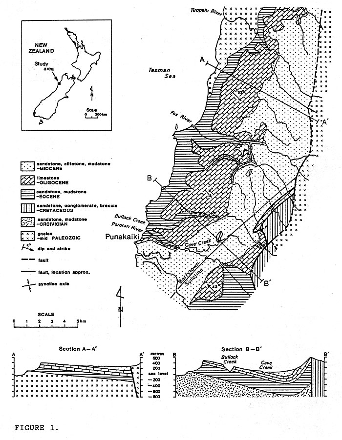
Figure 1: Geology of the Paparoa karst (after Laird, 1988)
This fine example of stream capture was a response to the development of steep hydraulic gradients resulting from the exposure of an inlier of limestone in the neighbouring catchment of Cave Creek. Aquifer development has been quite extensive and comprises the full spectrum of diffuse and conduit components.
The Bullock Creek aquifer is developed wholly within the Potikohua Limestone. Thickness of the unit varies between 80 and 140m, subdivided into an upper stylobedded, flaggy member and a lower massive member. Petrographically a polyzoan biosparite (Folk, 1959), it averages 90% CaCO3.
Objectives
The Bullock Creek aquifer, and indeed the whole of the Paparoa karst, has received scant scientific attention. The research presented here forms part of a larger project aimed at investigating the regional karst geomorphology and hydrology.
Because of its significance to the regional hydrology, much of the work thus far has been directed to identifying and quantifying the main components of the Bullock Creek aquifer: recharge, storage, internal flow routing and discharge. The objective of this paper is to discuss some of those results, and present a possible structural and functional interpretation of a karst aquifer system which is notable for its flashy recharge characteristics.
Methodology
Identification of recharge and discharge points, and delineation of groundwater boundaries has been achieved using qualitative point-to-point water tracing, using Rhodamine WT and fluorescein. Both discrete and diffuse components of aquifer recharge are being monitored; the former by water level recorders on Bullock Creek and a smaller allogenic input, Cataract Creek, and the latter from a network of rain gauges.
Discharge from two of the four springs draining the aquifer, Cave Spring (CCE1) and Main Spring (CCE2), is measured using water level recorders. The two other resurgences, Waterfall Spring (CCE5) and Mystery Spring (CCEl0), are not able to be measured directly due to perennial and periodic submersion, respectively, by flow in Cave Creek. Their combined discharge is determined by gauging Cave Creek a short distance downstream, and subtracting the known discharges of Main Spring and Cave Spring.
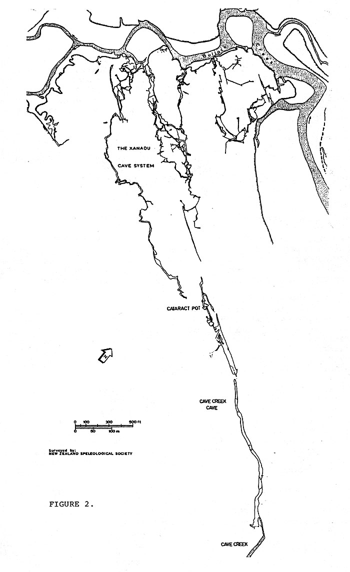
Figure 2: Map of the maze-like Xanadu Cave system and the single conduit of Cave Creek Cave
Investigation of conduit and diffuse aquifer components, storage and flow routing is being achieved primarily through the interpretation of breakthrough curves determined from high precision fluorometric tracing (Brown, 1973; Atkinson et al, 1973; Smart, 1983, 1988). Complementary data are provided by natural tracers, including flood pulse (Ashton, 1966; Williams, 1977), water temperature and water chemistry.
A water level recorder located within a short vadose cave, Flip-Flop (BCl31), which intersects a major phreatic conduit, supplies data on fluctuations of the piezometric surface within the aquifer. This information is being used to assess critical routing thresholds and storage dynamics within the aquifer.
Aquifer Structure
The Bullock Creek aquifer consists of three strongly constrasting structural elements: a complex epiphreatic floodwater maze (Xanadu Cave) system, a large vadose conduit (Cave Creek Cave), and an apparently simple, predominantly phreatic, interstratal conduit system.
The Xanadu system is fed by a number of streamsinks bordering the intermittent stream bed of Bullock Creek. Its well developed maze-like pattern (Figure 2) has developed along a reticulate network of joints and small scale faulting. In common with many epiphreatic maze caves (Palmer, 1975), it simplifies down-dip. Terminal sumps and very narrow fault controlled passages mark the downstream limit of exploration.
Palmer ascribes the development of this type of cave morphology to periodic, large and rapid recharge variations, causing short-lived increases in groundwater flow that flood all or part of a cave to the ceiling. The consequent development of areas of great hydrostatic pressure upstream of flow constrictions, allows the rapid development of maze-like diversion passages around the constriction, as well as blind tubes, spongework and ceiling pockets.
Palmer's scheme of epiphreatic maze development accords extremely well with the known structure and hydrology of the Xanadu Cave system. The system consists of more than 5km of passages, which have been known to fill completely in less than 60mins. Hydrological storage is small and flood recession is both rapid and complete; with the exception of the terminal sumps, all the accessible passages drain completely upon cessation of recharge. Deposits of sand, gravel and boulders, some of which are partially calcite cemented, and some vegetal debris, obstruct numerous passages. There is considerable evidence to suggest evacuation of previously occluded passages.
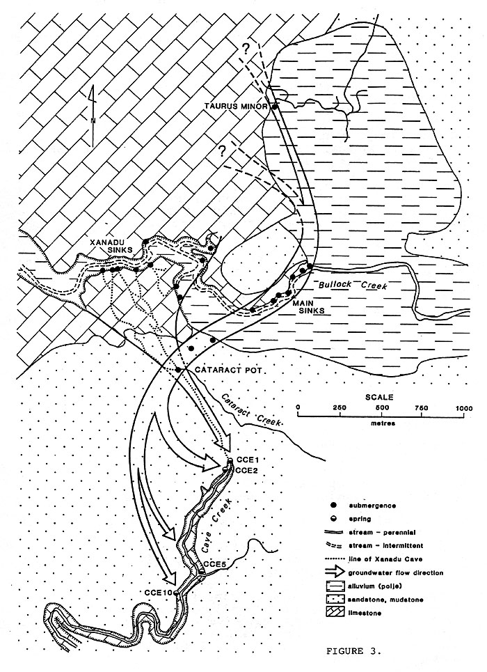
Figure 3: Hydrogeological setting and generalised groundwater pathways of the Bullock Creek karst aquifer
In a direct line and a short distance from the known limit of the Xanadu system, is Cave Creek Cave (Figure 2). Originally mapped as two separate caves, Myopia and Cave Creek Cave (Emberson, 1984), it is in fact a single conduit with a short sump midway along its length. Despite its proximity to, and hydrological continuity with the Xanadu system, Cave Creek Cave is remarkable for its contrasting form. It is essentially a single conduit, approximately 1000m in length, with cross sectional areas ranging between 50 and 300 m2. Headward sumps receive flow from the surface catchment of Cataract Creek, which submerges through the 40m shaft of Cataract Pot. These sumps are thought to be continuous with the terminal sumps in the Xanadu system. Apart from a negligible input from a small number of surface derived tributaries, flow in the cave only occurs during flooding in Bullock Creek, and emerges from the cave exit (Cave Spring), at the head of Cave Creek.
Due to its inaccessible nature, the structural form of the phreatic component of the aquifer is the least understood. Spatial position, as determined through dye tracing, is shown on Figure 3.
Aquifer Hydrology
Recharge
Groundwater recharge occurs in three distinct zones: (1) the semi-blind border polje through which Bullock Creek flows, (2) an extensive plateau, dominated by polygonal karst, to the northwest of the polje and (3) a similar, though less extensive, polygonal karst to the southwest.
In terms of total flow volumes, Bullock Creek dominates aquifer recharge. The majority of recharge within the polje occurs along a 2km section of stream bed, although some recharge through the extensive veneer of unconsolidated polje sediments almost certainly occurs.
Apparent upstream retreat of sink points has left a line of streamsinks along the normally dry stream bed, all of which are periodically reactivated during floods. At least 20 discrete streamsinks are known, though many more will exist, having been obscured by the highly mobile gravel bed of Bullock Creek.
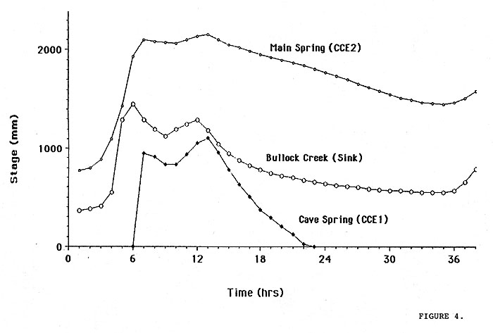
Figure 4: Simultaneous recharge - discharge hydrographs for the Bullock Creek aquifer. Event started at 0700, 21st May, 1989.
Under low flow conditions (<5m3s-1) Bullock Creek sinks entirely in the topmost swallet. As discharge increases, the downstream streamsinks become progressively reactivated. The volume absorbed varies directly with river stage, with a total capacity, in high flood, in the order of 40 m3s-1. Flow which exceeds the sink capacity for a given stage reoccupies the lower gorge. This probability for overflow, and consequent surface flow, can be considered typical of fluviokarst.
Because of regular, large and intense rainfalls over a steep, centripetally drained catchment, flooding occurs both frequently and quickly. Streamflow data for Bullock Creek from May 1988 to May 1989 showed that floods exceeding 10m3s-1 occurred on approximately 90 days. In the same period, bankfull discharge (approximately 70m3s-1) is assumed to have occurred on about 12 separate occasions.
The second major area of aquifer recharge, the karst plateau to the northwest, is entirely autogenic. It is assumed to have a continuum of recharge types ranging from concentrated to dispersed (Smart and Hobbs, 1987). Delineation of the groundwater boundaries within this region has not yet been possible because of the inaccessible terrain and a lack of surface drainage in which to introduce a tracer. Catchment boundaries in this area are estimated from geologic and topgraphic data only. Specific discharge values, derived from a water balance analysis in the small Cataract Creek catchment, will be used to provide an independent assessment of these conjectural boundaries. The third recharge zone, though geomorphically similar to the karst plateau to the northwest, has elements of both autogenic and allogenic recharge. Autogenic recharge is similar in type to the karst plateau, whilst allogenic recharge occurs as concentrated sinks along the limestone - mudstone boundary (e.g. Cataract Creek).
Discharge
Four springs, located along a 1 km section of Cave Creek, provide the focus for all the discharge from the Bullock Creek aquifer. Although field logistical difficulties have so far precluded accurate gauging of discharge at high flows, it is thought that the collective discharge from all the springs is in the order of 40-50m3s-1.
Hydrologically, the springs are divisible into 3 categories, based on the type and duration of flow. The two lower, and closely spaced springs, Waterfall Spring and Mystery Spring, exhibit relatively steady and perennial discharge characteristics. Such behaviour, resulting from the maintenance of a more or less uniform hydraulic head, conforms to the concept of an 'underflow' spring (Smart, 1983). Both of these springs show closely matched behaviour and appear to be related functionally.
The other two springs in the hierarchy, Main Spring and Cave Spring are located adjacent to each other, at the head of Cave Creek. In terms of total aquifer discharge, Main Spring dominates the spring hierarchy. Flow rates vary between 0.1 to 15m3s-1. Flow characteristics of Main Spring can therefore be described as 'unsteady perennial'. Direct observations made from diving this resurgence (Emberson, 1984), showed that flow rises steeply to the surface via a 30m conduit, approximately 3m by 1.5m in cross section. Thus the existence of a phreatic loop is indicated. Although diving beyond this vertical shaft was restricted by excessive flow velocities, the route immediately upstream of the shaft was observed to occupy a constricted horizontal bedding plane passage.
Cave Spring is an outstanding example of an overflow system. Flow is intermittent, exhibits a strong peakedness and shows no sustained recession. Consequently, its flow characteristics can be described as 'unsteady intermittent'. There is a clear association between discharge from Cave Creek Cave and hydrographic stage in the Main Spring (Figure 4). Analysis of a number of flood events shows that the Cave Spring begins to discharge when the Main Spring reaches a stage of approximately 1900mm. Also noticeable is an attenuation of the hydrograph peak of the Main Spring whilst Cave Creek Cave is discharging.
It is considered that an increase in apparent flow resistance with increasing discharge (e.g. Lauritzen et al, 1985) is the dominant mechanism for the attenuation of the Main Spring hydrograph and activation of the Cave Creek Cave flood route. The large size of Cave Creek Cave results in the accommodation of considerable increases in outflow with little variation in hydraulic head; thus accentuating the attenuation of the Main Spring hydrograph.
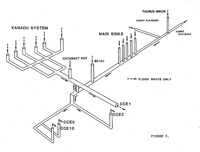
Figure 5: Conceptual interpretation of the qualitative structure and hydrological behaviour of the Bullock Creek aquifer. Only the main elements are shown.
Quantitative Hydrology and Dye Tracing
Under low flow conditions, water movement between Bullock Creek and Cave Creek is confined wholly within the phreatic aquifer component, resurging from Main Spring (CCE2), waterfall Spring (CCE5) and Mystery Spring (CCE10) (Figure 4).
Recharge from Cataract Creek, and subcutaneous stores overlying the Xanadu system, drain into the phreatic system through an, as yet, unidentified connection. As the flow in Bullock Creek increases two processes occur: (1) the phreatic throughput increases, raising the piezometric level within the aquifer. Strandline deposits observed in Flip-Flop Cave, in the passage immediately above its junction with the phreatic conduit, indicate water level rises of a least 30 m (2) The streamsink 'front' moves down Bullock Creek and if flow is sufficient, the Xanadu system is reactivated.
At some threshold of recharge, flow through the Xanadu-phreatic link passage reverses (Figure 5). The resulting flow from Cave Creek Cave-Cave Spring (CCE1) consists of water from Xanadu, Cataract Creek, dispersed recharge from the surface, and a varying quantity from the phreatic system (Figure 5). Replicate dye traces, under low and high flow conditions, into both Cataract Creek and Xanadu confirm this reversing flow hypothesis. Field access difficulties during high flow conditions have so far precluded similar replicate traces into the Main Sinks.
Tracer velocities between the Main Sinks and Main Spring, exhibit a very strong dependence on system input. The traces conducted thus far (low-intermediate flow only) showed travel time varied from 2.5 to 7.5 hrs for submergence inputs of 8.2 to 3.5m3s-1, respectively. With a sampling frequency of 30 mins, the resultant breakthrough curves show a simple unimodel form. Aliasing (Smart, 1988), resulting from an insufficient sampling frequency, may be masking a more complex curve form.
Preliminary pulse-wave experiments, using natural flood events, have given pulse-through times of between 15 and 45 mins, for the same groundwater pathway between the Main Sinks and Main Spring. The significant difference between pulse-through and flow-through times verify the predominantly phreatic nature of this connection, though some vadose flow is indicated (and known).
The area of greatest hydrological uncertainty is the fate of recharge from the karst plateau. The hypothetical connection (Figure 4) with the Bullock Creek aquifer is based solely on the following indirect evidence:
- Geological control and dip is assumed to direct groundwater flow beneath the plateau towards the synclinal axis.
- The recession for the Main Spring is significantly lagged behind that of Bullock Creek, which implies a dispersed and diffuse recharge component to the spring recession.
- The few known springs draining the margins of the karst plateau have a collective discharge many orders of magnitude smaller than would be expected if they drained the whole plateau. The likelihood of undiscovered springs is very small.
Synthesis of the results and observations thus far allow the Bullock Creek aquifer to be considered in terms of the simple structural functional model depicted in (Figure 5). Though not to scale, and verifiable only in the accessible portions of the aquifer, the model provides a 'best fit' to the data.
CONCLUSIONS
A high recurrence of large, intense rainfalls and consequent flooding results in the Bullock Creek aquifer experiencing a highly dynamic flow regime. The juxtaposition and hydrological integration of a diverse spectrum of aquifer components is structurally and functionally related to that flow regime. Form, function and process in aquifer development are clearly interwoven by complex synergistic relationships.
ACKNOWLEDGEMENTS
The New Zealand Department of Conservation is providing generous financial and logistical support for the project. The Westland Catchment Board have kindly made available equipment and data. Professor P.W. Williams (University of Auckland) is supervising the research.
REEFERENCES
Ashton, K. (1966) The analysis of flow data from karst drainage basins. Transactions of the Cave Research Group of Great Britain, 7, pp 161-203
Atkinson, T.C., Smith, N.I., Lavis, J.J. and Whittaker, R.J. (1973) Experiments in tracing underground waters in limestones. Journal of Hydrology, 35, pp 93-110
Brown, M.C. (1973) Mass balance and spectral analysis applied to karst hydrologic networks. Water Resources Research, 9, pp 749-752
Emberson, R. (1984) Cave Creek Cave, Punakaiki; New Zealand Speleological Bulletin, 7(130), pp 263-268
Folk, R.L. (1959) Practical petrographic classification of limestones. Bulletin of the American Association of Petroleum Geologists, 43(1), pp 1-38
Laird, M.G. (1988) Sheet S37 - Punakaiki, Geological map of New Zealand 1:63360. Flap (1 sheet) with notes. Department of Scientific and Industrial Research, Wellington, New Zealand.
Lauritzen, S.E., Abbott, J., Arnessen, R., Crossley, A., Grepperud, D., Ive, A. and Johnson, S.(1985) Morphology and hydraulics of an active phreatic conduit. Cave Science, 12, pp 139-146
Palmer, A.N. (1975) The origin of maze caves. National Speleoloqical Society Bulletin, 37(3), pp 56-76
Smart, C.C. (1983) Hydrology of a glacierised alpine karst, Castleguard Mountain, Alberta. Unpublished PhD thesis, McMaster University, Hamilton, Ontario, 343pp
Smart, C.C. (1988) Artificial tracer techniques for the determination of the structure of conduit aquifers. Groundwater, 26(4), pp 445-453
Smart, P.L. and Hobbs, S. (1987) Characterisation of karst aquifers: a conceptual base. Problems in Karst Terraines and Their Solutions Conference. Proceedings. Dublin, Ohio: National Water Well Association, 525pp
Williams, P.W. (1977) Hydrology of the Waikoropupu Springs: a major tidal karst resurgence in northwest Nelson (New Zealand). Journal of Hydrology, 35, pp 73-92