INTERIM MANAGEMENT PROPOSALS FOR EXIT CAVE STATE RESERVE, IDA BAY, TASMANIA
INTRODUCTION
By Statutory Rule No. 38 of 1979 a 440.5 hectare State Reserve was established over caves at Ida Bay, Tasmania (Fig. 5). State Reserves are gazetted under the Tasmanian National Parks and Wildlife Act of 1971. This legislation and its management implications were discussed by G.J. Middleton at the last Cave Management Conference. It is my intention to outline some of the management problems of the new reserve and to present some interim management suggestions. Under the legislation management plans are required to be drawn up for all reserved lands. As it may be some time before such a plan can be prepared for the new reserve I am proposing some interim measures, and, at least, identifying problems involved.
BACKGROUND
Exit Cave is Australia's longest cave with over 17 kilometres of known passage. There is a large glowworm population which has been favourably compared to similar displays in New Zealand. Speleothemic decoration is unusual with extensive moonmilk and gypsum areas.
Exit Cave was almost certainly known by timber workers in the 1890s as a timber tramway built in the period is evident near the entrance. The Tasmanian Caverneering Club first visited the cave in 1947 but due to difficulties with surface access little exploration was undertaken until 1966 when a new access track was cut from the south. The period from 1966 to 1971 was one of extensive speleological investigation and the area was well-known by the early 1970s. One mystery still eludes cave explorers: the question as to whether there is a link with Mystery Creek Cave on the northern side of Marble Hill. The early exploratory work in Exit Cave is attributed to Mr Brian Collin and his wife Jeanette and Mr Albert Goede and without their enthusiasm and persistence Exit Cave could to this day remain unknown. The stream in Exit Cave has captured the headwaters of Mystery Creek from the Lune River catchment into the D'Entrecasteaux River. This underground river capture has been proven by Albert Goede and his assistants using dye in 1968 but it is not known if there is a physical link apart from water filled passages.
ESTABLISHMENT OF THE RESERVE
The first move for a reserve to protect Exit Cave came some twelve years ago in 1967 when the Tasmanian Caverneering Club approached the Scenery Preservation Board about the matter. This was followed up with a detailed submission in 1971 from the Club to the Board's successor, the Tasmanian National Parks and Wildlife Service. The Service was in favour of the idea and circulated a proposal to other Government departments for comment. There was opposition from forestry interests who contended that logging operations above the cave would not affect its ecological integrity. Thus the reserve proposal was stalemated until the Parks Service Commission Drs A. Richards and C. Ollier to report on the logging question. They found that logging would indeed have an effect on the cave, although there were differences as to the degree of damage likely.
Subsequently the area involved was removed from the existing timber concession from a private forestry company and the reserve was created. No forestry or mining rights now pertain to the area actually reserved but the area is not adequate as:
- Part of Conference Concourse in Exit Cave is left out of the reserve,
- Half of Mystery Creek Cave is unprotected,
- Important potholes such as Midnight Hole are omitted,
- The catchment of Mystery Creek is left out, so that the ecological integrity of Mystery Creek Cave could be at risk should logging operations be permitted in the vicinity,
- Areas left out of the State Reserve to the north and east are covered by existing mining leases. Limestone quarrying could occur in close proximity to the new reserve with deleterious effects.
Despite these shortcomings the new reserve must be applauded as an important step but neighbouring land use must be sympathetic if the reserve is to be viable.
ACCESS POLICY AND GATING
A gate to Exit Cave was erected in 1969 and the key is presently held by ranger staff at Hastings Caves. However, the large streamway entrance is not blocked off and the feasibility of gating this should be investigated. Access is possible through this entrance in dry weather and small amounts of vandalism have occurred during the past ten years. Access in the past has been largely controlled by the Tasmanian Caverneering Club. Now that the area is reserved ranger staff at Hastings control access. It is suggested that access be limited to A.S.F. affiliated groups and adventure excursion groups.
WILDERNESS TOURS
R.K. Skinner operates excursions to Exit Cave and he presented a paper on this matter to the last cave management conference. Small groups are conducted to the first kilometre of the cave on day trips. The desirability of this type of excursion as opposed to "standard" mass tourism development should be closely studied before any proposals to further develop Exit Cave are entertained. I am of the personal opinion that the present type of excursion operation is appropriate but that tight controls must be kept on it so that delicate formation areas remain undamaged as much as possible. I would prefer to see Exit Cave left undeveloped in its present state. I do not wish to indulge in a discussion as to why one of Australia's major caves should be left for speleo enthusiasts and adventure excursionists as I believe that wilderness conservationists have adequately justified the issue at many other forums.
I would add that the existing show cave in the area, Newdegate Cave at Hastings, is at visitor load capacity during peak periods; but this is mainly due to congestion on the re-tracing tour. The feasibility of building a tunnel to create a through trip should be investigated. If a through trip could be provided the existing show cave could handle more visitors.
UNDERGROUND CAMPING
Due to the access difficulties during the early exploratory trips to Exit Cave during the period 1966-71 a tradition arose that groups would camp inside the cave. Whilst this was very convenient at the time, (I can certainly vouch for that!) there are problems with faeces and rubbish. For normal "recreational" caving underground camping should not be permitted and the A.S.F. Code of Ethics specifically refers to it as an undesirable practice. There may be excursions when the granting of special permits for underground camping could be issued; including exploration, surveying and scientific purposes.
MOONMILK FLOORS
Damage has occurred to the delicate moonmilk floors in the high level sections of the first kilometre of Exit Cave. This is inevitable if speleo-enthusiasts and adventure excursionists are to visit these areas. The problem has been minimised by the installation of string barriers held up by tent pegs. These have been effective in the past but should be replaced by similar but larger and more obvious barriers so that visitors do not leave marked trails.
POLICY ON MYSTERY CREEK CAVE
This cave, on the northern side of Marble Hill, is adjacent to the old limestone quarry operated during the Second World War. It is visited by cavers, bushwalkers and the general public. The cave is almost totally devoid of speleothems so that little damage can be done to formations. The only obvious deterioration evident is rubbish accumulate and signatures on walls. There is no gate and no access restrictions apply. It is suggested that the present laissez-faire situation on access continue. Few visit the cave and scant damage during the seventy year use of the cave is evident. A sign should be erected warning visitors against damaging and littering the cave and also against the danger of being trapped inside due to flooding.
CONCLUSION
It has taken twelve years of effort by various dedicated people to have a reserve established to protect the cave system and it will be some time before an appropriate management role will be effective. Exit Cave is one of Australia's most significant and its appropriate management will be a challenge to those who are its custodians.
BIBLIOGRAPHY
DE VRIES, M.H. 1960. Exit Cave. T.C.C. Bulletin Vol. 1 No. 4
ELLIS, R. 1971. ASF Commission on Longest and Deepest Caves. ASF Newsletter 52
GOEDE, A. 1967. Letter to the Scenery Preservation Board (unpublished, T.C.C. Correspondence)
GOEDE, A. 1967. Underground stream capture at Ida Bay, Tasmania, and relevance of cold climatic conditions. Australian Geographical Studies 7
GOEDE, A. 1971. Submission to the National Parks and Wildlife Service (unpublished. T.C.C. Correspondence)
GOEDE, A. 1973. Possible effects of forestry activities on proposed cave reserve at Marble Hill, Ida Bay. (unpublished)
MIDDLETON, G.J., OLLIER. C.D. and RICHARDS, A. The Management of Tasmania's Caves. Cave Management in Australia II
SKINNER, A.D. 1973. A Problem of Deterioration. Speleo Spiel 78.
SKINNER, A.D. 1973. Mass Recreation at Ida Bay, the Development of Exit Cave (unpublished thesis).
SKINNER, R.K. 1977. Wilderness Cave Tours at Exit Cave. Cave Management in Australia II.
Fig 5 Exit Cave Regulations
|
STATUTORY RULES 1979, No. 38 National Parks and Wildlife Act 1970 A PROCLAMATION
(a) declare the areas of Crown land that are specified in Schedule 1 to STANLEY BURBURY, Governor By His Excellency's Command, SCHEDULE 1 All those 2 areas of land containing respectively 424.3 hectares or there SCHEDULE 2 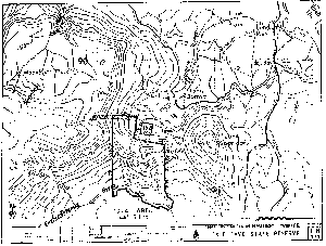
I certify that the foregoing proclamation is in accordance with the law. B. K. MILLER Attorney-General. Printed and numbered in accordance with the Rules Publication Act 1953. T. J. HUGHES, Government Printer, Tasmania |
 N pursuance of sections 14 (1) and 15 (1) of the